Updated Monday evening forecast — March 6th, 2017

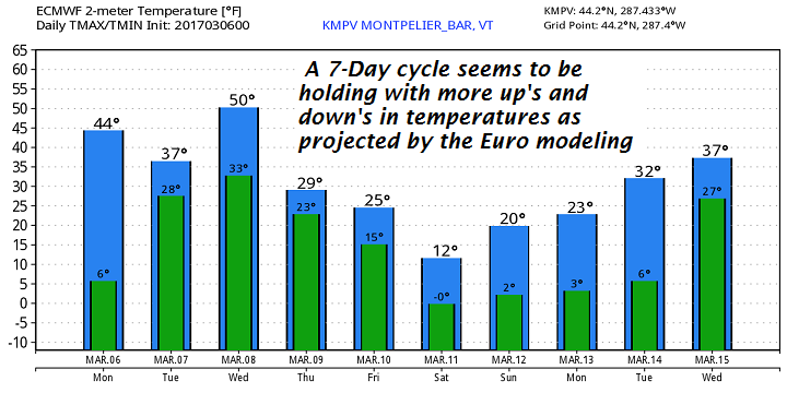
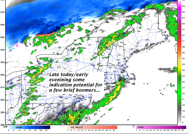
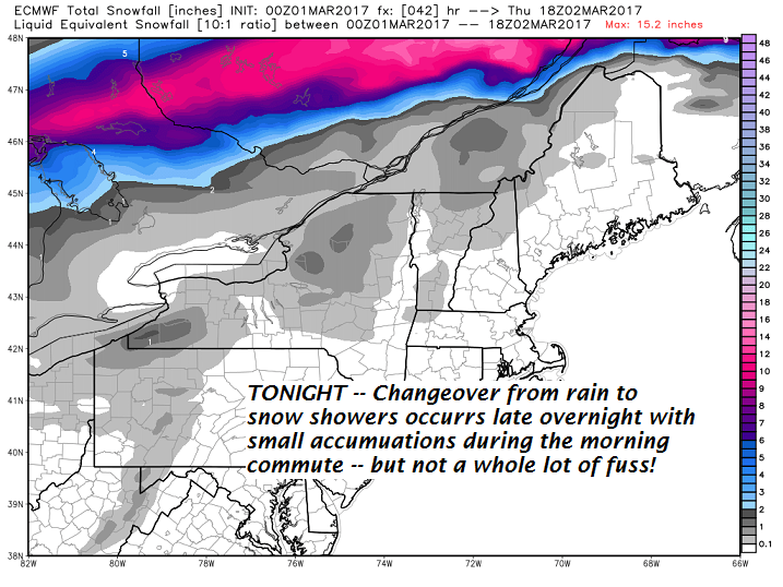
TONIGHT: Fair early with thickening clouds. Some spotty light mixed precipitation developing around or after midnight. Spotty areas east of the Green Mountains may become slick. A low around 30. Light southeast winds.

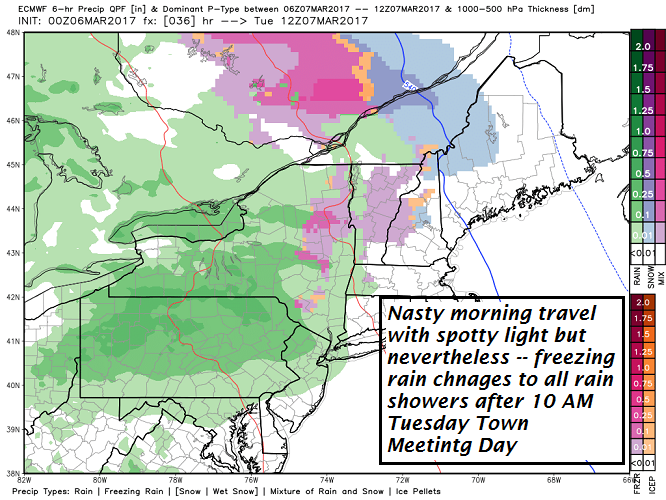
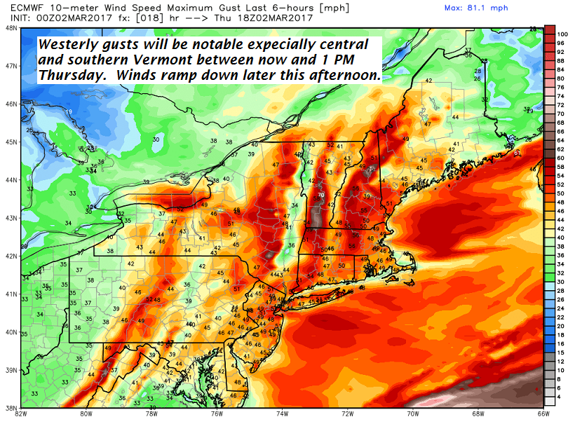
TOMORROW Town Meeting Day: Mostly gray. Spotty mixed precip making for slick spots through 10 am, then the occasional light rain shower. Temperatures gradually warm up into the mid to upper 30s. Southeast winds 10 to 20 mph.

TUESDAY NIGHT: Cloudy. Rain showers likely, possibly mixing with few wet snow flakes in the high terrain. A low around 35.

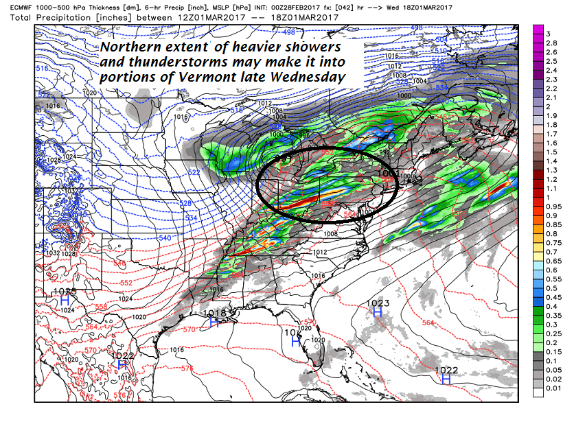
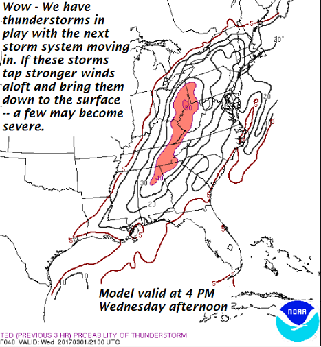
WEDNESDAY: Rain showers through late morning tapering to scattered leftover sprinkles in the afternoon with increasing amounts of sunshine. Mild with a high 45 to 50.

Looking Further ahead…

WEDNESDAY NIGHT: Scattered clouds in the evening, then clouding up with scattered snow showers or flurries. Minor accumulations. A low in the mid 20s.

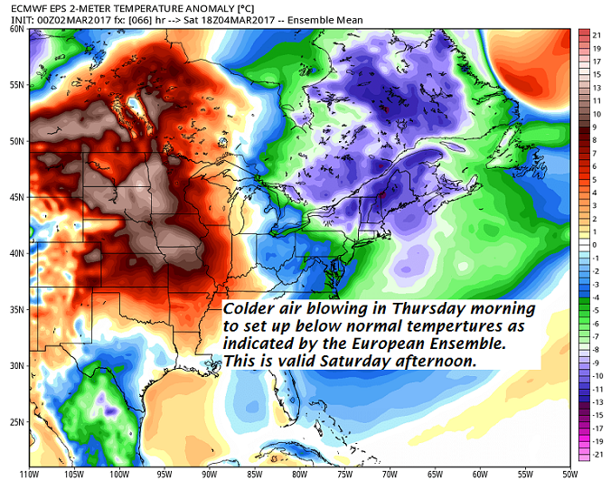
THURSDAY: Blustery and colder. Chance for a few morning flurries exiting to increasing amounts of sunshine. Temperatures holding in the mid to upper 20s. Gusty northwest winds lowering wind chills.

FRIDAY: Lots of sunshine. A low in the teens. A high around 25.

SATURDAY: Partly to mostly sunny but frigid. A low in the single digits. A high around 10 above

Average lows in the teens. Normal highs 35 to 40.

RH/3-6[end]

Updated Monday morning Forecast & WX Notes — March 6th, 2017

· Nice day today enjoy because a lot more nastiness is around the corner

· Unfortunate for Town Meeting folks – Likely dicey tomorrow morning.

· Below is my contempt for said politicians – apparently I’m far from alone, so much so they created this in Berlin Germany where they walk the talk about living green, unfortunately it pretty limited in North America

TODAY: Sunshine becoming filtered through high clouds at times. Much milder with a high in the upper 30s Northeast Kingdom to 40 to 45 elsewhere. Little wind.

TONIGHT: Fair early with thickening clouds leading to spotty freezing rain showers after midnight…producing areas very slick travel tomorrow. A low in the upper 20s to around 30. Southeast winds 10 to 15 mph across the hills.

TUESDAY Town Meeting Day: Gray. Freezing rain showers making for a very slick travel through about 10 AM, then occasional rain showers. Temperatures gradually warm up in the mid 30s to low 40s. Southeast winds 10 to 25 mph.

Looking Further ahead…

TUESDAY NIGHT: Cloudy. Rain showers likely, possibly mixing with few wet snow flakes in the high terrain. A low 32 to 35.

WEDNESDAY: Scattered leftover sprinkles gradually drying up, with increasing amounts of sunshine in the afternoon. Mild with a high mid 40s to low 50s.

THURSDAY: Mostly cloudy, blustery and much colder with a chance for minor snow showers or flurries. A low in the lower 20s. A high near 32. Gusty northwest winds.

FRIDAY: Lots of sunshine. A low in the teens. A high near 30.

Average lows in the teens. Normal highs 35 to 40.

RH/3-63[end]

Updated Friday Evening Forecast — March 3rd, 2017

Wind Chill Advisory Overnight through Noon Saturday…

TONIGHT: A few flurries this evening especially toward southern Vermont, Otherwise scattered clouds. Frigid. A low zero to 5 above. Northwest winds 10 to 15 mph lowering wind chills.

TOMORROW: Some morning clouds with a few stray flurries. Mostly sunny in the afternoon but blustery and cold with lowered wind chills. Frigid temperatures with a high 5 to 10 above. Northwest winds 10 to 25 mph.

SATURDAY NIGHT: Clear and cold. A low 5 below to 5 above. Northwest winds 10 to 15 mph lowering wind chills.

SUNDAY: Blue skies and bright sunshine. A high in the upper teens to mid 20s. Northwest winds around 10 mph.

Looking Further ahead…

SUNDAY NIGHT: Mostly clear. A low 5 to 10.

MONDAY: Sunshine filtered through high clouds at times, but otherwise becoming much more milder. Temperature rebounding into the low and mid 40s.

TUESDAY Town Meeting Day: Mainly cloudy and gray. Chance for rain showers beginning as a brief period of freezing rain and slick travel in the morning. Breezy at times. A low 25 to 30. A high 40 to 45.

WEDNESDAY: Chance for rain showers…exiting in the afternoon to partial sunshine with a leftover sprinkles or two. A low around 32. A high 45 to 50.

Average lows 10 to 15. Normal highs around 35.

RH/3-3[end]

Updated Friday morning forecast & WX notes — March 3rd, 2017

· One of the better things about colder arctic chunks of air that will center line over us Satruday – is the clarity to the atmosphere barring any nebulouse looking diamond dust flurries…

· Coldest pool of air arrives first part of Saturday…

· Early next week – We see a mild intrusion. This will touch off more sap runs for sugarers.

SNOW LOVERS – forgetaboutit! Below next 7 days snow accumulation…

TODAY: Morning sun gives way to variable clouds this afternoon. Chance for a few flurries arriving late. Rather cold. A high 20 to 25. Northwest winds 10 to 20 mph.

Wind Chill Advisory Overnight through Noon Saturday…

TONIGHT: Scattered clouds. Frigid. A low 5 below to 10 above. Northwest winds 10 to 15 mph lowering wind chills.

SATURDAY: Morning clouds with a few stray flurries. Partly to mostly sunny in the afternoon but blustery and cold with lowered wind chills. A high close to 10 above. Northwest winds 10 to 25 mph lowering wind chills.

Looking Further ahead…

SATURDAY NIGHT: Clear and cold. A low 5 below to 5 above.

SUNDAY: Blue skies and bright sunshine. A high 20 to 25.

MONDAY: Sunshine filtered through high clouds at times, but otherwise becoming much more milder. A low 5 to 10. Temperature rebounding into the low and mid 40s.

TUESDAY: Mainly cloudy and gray. Chance for rain beginning as mixed precipitation and slick travel possible in the morning. Breezy at times. A low 25 to 30. A high in the low to mid 40s.

WEDNESDAY: Chance for leftover rain showers…exiting in the afternoon to periods of sunshine . A low around 32. A high 45 to 50.

Average lows 10 to 15. Normal highs around 35.

RH/3-3[end]

Updated Thursday Evening forecast — March 2nd, 2017

TONIGHT: Mostly clear and chilly. A low in the low teens. Northwest winds 10 to 20 mph

TOMORROW: Variable clouds with intervals of sunshine. Slight threat for a few flurries late. Rather cold. A high in the upper teens to low 20s. Northwest winds 10 to 20 mph.

FRIDAY NIGHT: Scattered clouds. Frigid. A low 5 below to 10 above. Northwest winds 10 to 15 mph lowering wind chills.

SATURDAY: Morning clouds with a stray mountain flurry or two, mixing with more sunshine in the afternoon. Blustery at times and very cold with lowered wind chills. A high in the upper single digits to low teens. Northwest winds 10 to 25 mph and gusty lowering wind chills.

Looking Further ahead…

SATURDAY NIGHT: Clear and cold. A low 5 below to 5 above.

SUNDAY: Blue skies and bright sunshine. A high 20 to 25.

MONDAY: Sunshine filtered through high clouds. A low 5 to 10. Temperature rebounding into the low and mid 40s.

TUESDAY: Cloudy and gray. Chance for rain beginning as mixed precipitation and slick travel possible. r rain showers and breezy to windy. A low 25 to 30. A high 45 to 50.

WEDNESDAY: Chance for rain showers exiting in the afternoon to periods of sunshine . A low around 35. A high in the mid 40s to around 50.

Average lows in the upper single digits to mid teens. Normal highs in the mid 30s.

RH/3-2[end]

Updated Thursday morning Forecast & WX notes — March 2nd, 2017

· Snow showers were moving through during the morning commute…

Strong and gusty westerly winds pushing east out of New York arrive this morning and last into as portion of the afternoon…

· The Cold front of this Thursday morning…will deliver colder than normal temperatures into the weekendwith the coldest day likely to be Satruday…followed by a moderation Sunday afternoon…

· Looky what’s around the corner! More warmth!

Wind Advisory through 7 PM…

TODAY: Blustery and turning sharply colder. Scattered snow showers or flurries exiting in the afternoon, otherwise clouds mixing with intervals of sunshine. Temperatures falling through the 30s into the upper and mid 20s. West to northwest winds 10 to 25 mph with gust over 45 mph possible this morning into the afternoon.

TONIGHT: Mostly clear and chilly. A low in the low to mid teens. Northwest winds 10 to 20 mph

FRIDAY: Variable clouds with intervals of sunshine. Rather cold. A high 20 to 25. Northwest winds 10 to 20 mph.

Looking Further ahead…

FRIDAY NIGHT: Scattered clouds. Frigid. A low 5 below to 10 above.

SATURDAY: Morning clouds with a stray mountain flurry or two, mixing with more sunshine in the afternoon. Blustery at times and very cold with lowered wind chills. A high 10 to 15.

SUNDAY: Blue skies and bright sunshine. A very cold start with a low 5 below to 10 above. A high 20 to 25.

MONDAY: Sunshine giving way to more clouds. A threat for a snow shower or flurry. A low 5 to 15. Temperature rebounding into the mid 30s to mid 40s.

TUESDAY: Clouding up with a chance for rain showers and breezy to windy. A low new 32. A high around 50.

Average lows in the upper single digits to mid teens. Normal highs in the mid 30s.

RH/3-2[end]

Updated Wednesday evening Forecast — March 1st, 2017

TONIGHT: Scattered or occasional rain showers…maybe a rumble or two of thunder this evening. Rain showers… changing over to snow showers or flurries toward daybreak. Less than an inch accumulation. A low around 25. Southwest winds 10 to 20 mph.

TOMORROW: Blustery and colder. Scattered light snow showers or flurries exiting in the afternoon to intervals of sun late. Temperatures falling through the upper and mid 20s. Increasing west to northwest winds 10 to 25 mph with higher gusts.

THURSDAY NIGHT: Mostly clear and chilly. A low in the low to mid teens. Northwest winds 10 to 20 mph

FRIDAY: Variable clouds with intervals of sunshine. Rather cold. A high in the mid 20s. Northwest winds 10 to 20 mph.

Looking Further ahead…

FRIDAY NIGHT: Scattered clouds. Frigid. A low 5 below to 10 above.

SATURDAY: Morning clouds with a stray mountain flurry or two, mixing with more sunshine in the afternoon. Blustery at times and very cold with lowered wind chills. A high in the teens.

SUNDAY: Blue skies and bright sunshine. A very cold start with a low 5 below to 10 above. A high in the low to mid 20s.

MONDAY: Sunshine giving way to more clouds. A threat for a snow shower or flurry. A low 5 to 15. Temperature rebounding into the mid 30s to mid 40s.

TUESDAY: Clouding up with a chance for rain showers and breezy to windy. A low new 30. A high in the upper 40s to mid 50s.

Average lows in the upper single digits to mid teens. Normal highs in the mid 30s.

RH/3-1[end]

Updated Wednesday morning Forecast & WX Notes — March 1st, 2017

· Out of season thunderstom activity was “possible” not certain with best chances later today or early this evening in what will be a very mild warmer air mass on this first day of March.

· Snowflakes in the air perhaps not sticking that much on the ground tomorrow morning based on timing of coldest working in.

· Temperatures were likely to fall between 4 AM through Noon Wednesday as blustery winds blow in a shot of more seasonable Canadian air.

· Sugaring conditions to take a respite but a minor warm up indicated middle of next week again

TODAY: Mainly cloudy and gray, but very mild. Rain showers with a threat for a rumble or two of thunder this afternoon. Balmy…with record highs of in the mid 50s to low 60s. South winds 10 to 20 mph with higher gusts possible.

TONIGHT: Scattered or occasional rain showers…maybe a rumble or two of thunder this evening. Rain showers… changing over to snow showers or flurries toward daybreak. Less than an inch accumulation. A low around 25. Southwest winds 10 to 20 mph.

THURSDAY: Blustery and colder. Scattered light snow showers or flurries exiting in the afternoon to intervals of sun late. Temperatures falling through the upper and mid 20s. Increasing west to northwest winds 10 to 25 mph with higher gusts.

Looking Further ahead…

THURSDAY NIGHT: Mostly clear and chilly. A low in the low to mid teens.

FRIDAY: Partly to mostly sunny but rather cold. A high in the mid 20s.

SATURDAY: Sunshine giving way to high clouds. Cold. A low 5 to 15 above. A high in the teens.

SUNDAY: Mostly sunny and not as cold. A low in the single digits. A high 25 to 30.

MONDAY: Clouds with a chance for light snow showers. A low in the 20s. Highs in the 30s.

Average lows in the upper single digits to mid teens. Normal highs in the mid 30s.

RH/3-1[end]

Tuesday Evening forecast — February 28th, 2017

TONIGHT: Cloudy. Slight chance for a rain shower. A low in the upper 30s to low 40s. Southeast winds 10 to 15 mph across the hills.

TOMORROW: Mainly cloudy and gray and very mild. Intermittent light rain or showers with a threat for a thunderstorm later in the day. Breezy at times. Record highs of around 60 degrees. South winds 10 to 20 mph with higher gusts possible..

WEDNESDAY NIGHT: Rain showers with a chance for a thunderstorm in the evening. Rain showers…mixing with and changing over to snow showers or flurries overnight. Less than an inch accumulation. A low around 25. Southwest winds 10 to 20 mph.

THURSDAY: Blustery and colder. Scattered light snow showers or flurries exiting in the afternoon to intervals of sun late. A high in the low to mid 30s. West to northwest winds 10 to 25 mph with higher gusts in the hills.

Looking Further ahead…

THURSDAY NIGHT: Mostly clear and chilly. A low in the teens.

FRIDAY: Partly to mostly sunny but rather cold. A high in the 20s.

SATURDAY: Sunshine giving way to high clouds. Cold. A low 5 to 15 above. A high in the mid teens to low 20s.

SUNDAY: Mostly sunny and not as cold. A low in the single digits. A high near 30.

MONDAY: Thickening high clouds. A low in the 20s. Highs in the 30s.

Average lows in the upper single digits to mid teens. Normal highs in the mid 30s.

RH/2-28[end]

Updated Tuesday Morning forecast & WX Notes — February 28th, 2017

· Nice day to start but will end cloudy and becoming damp late today with increasing chances for rian showers…though fairly light.

· Are we setting up for another wild ride for the first of March with a chancy low cape high shear thunderstorms mixed within batches of otherwise run of the mill rain showers? Latest modeling seems to say – yes!

· Wednesday afternoon and early evening could be interesting…

· Much colder more seasonal weather to follow —

TODAY: High cloudiness filtering the sunshine into the early afternoon. Thickening clouds late with a chance for a rain shower. A high in the mid to upper 40s. South breeze 10 to occasionally 20 mph.

TONIGHT: Cloudy. Scattered rain showers. A low in the upper 30s to low 40s. Southeast winds 10 to 15 mph across the hills.

WEDNESDAY: Mainly cloudy and gray. Breezy to windy in the afternoon. Periods of light rain or showers likely. Chance for a late day thunderstorm…especially toward Rutland. Milder with a high in the upper 50s to low 60s. South winds 10 to 20 mph.

Looking Further ahead…

WEDNESDAY NIGHT: Light rain showers, mixing with and changing over to snow showers or flurries overnight. A low 20 to 25.

THURSDAY: Blustery and colder. Scattered light accumulating snow showers exiting in the afternoon to intervals of sun late. A high in the upper 20s to around 30.

FRIDAY: Partly to mostly sunny but rather cold. A low in the teens. A high in the 20s.

SATURDAY: Sunshine giving way to high clouds. Cold. A low 5 to 15 above. A high in the mid teens to low 20s.

SUNDAY: Mostly sunny and not as cold. A low in the single digits to low teens. A high upper 20s to low 30s.

MONDAY: Thickening high clouds. Lows in the teens. Highs in the 30s.

Average lows in the upper single digits to mid teens. Normal highs in the mid 30s.

RH/2-28[end]