
· Nice day to start but will end cloudy and becoming damp late today with increasing chances for rian showers…though fairly light.

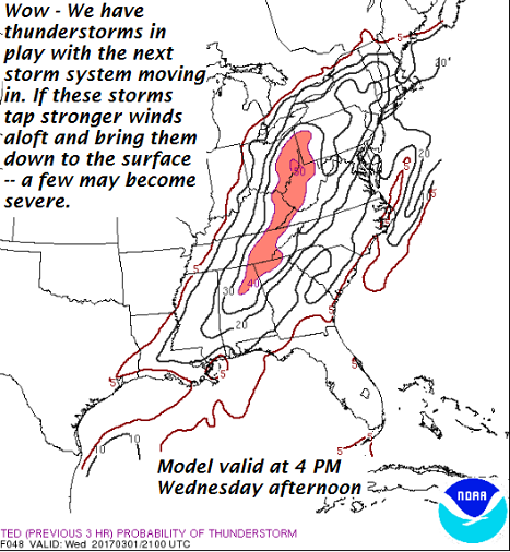
· Are we setting up for another wild ride for the first of March with a chancy low cape high shear thunderstorms mixed within batches of otherwise run of the mill rain showers? Latest modeling seems to say – yes!
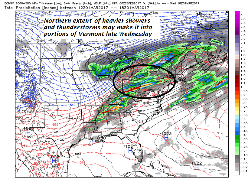
· Wednesday afternoon and early evening could be interesting…
· Much colder more seasonal weather to follow —
TODAY: High cloudiness filtering the sunshine into the early afternoon. Thickening clouds late with a chance for a rain shower. A high in the mid to upper 40s. South breeze 10 to occasionally 20 mph.
TONIGHT: Cloudy. Scattered rain showers. A low in the upper 30s to low 40s. Southeast winds 10 to 15 mph across the hills.
WEDNESDAY: Mainly cloudy and gray. Breezy to windy in the afternoon. Periods of light rain or showers likely. Chance for a late day thunderstorm…especially toward Rutland. Milder with a high in the upper 50s to low 60s. South winds 10 to 20 mph.
Looking Further ahead…
WEDNESDAY NIGHT: Light rain showers, mixing with and changing over to snow showers or flurries overnight. A low 20 to 25.
THURSDAY: Blustery and colder. Scattered light accumulating snow showers exiting in the afternoon to intervals of sun late. A high in the upper 20s to around 30.
FRIDAY: Partly to mostly sunny but rather cold. A low in the teens. A high in the 20s.
SATURDAY: Sunshine giving way to high clouds. Cold. A low 5 to 15 above. A high in the mid teens to low 20s.
SUNDAY: Mostly sunny and not as cold. A low in the single digits to low teens. A high upper 20s to low 30s.
MONDAY: Thickening high clouds. Lows in the teens. Highs in the 30s.
Average lows in the upper single digits to mid teens. Normal highs in the mid 30s.
RH/2-28[end]
