Updated Evening Forecast —

March 27th, 2017

TONIGHT: Mainly cloudy. Widely scattered rain showers northern areas. A low around 35. Light winds.

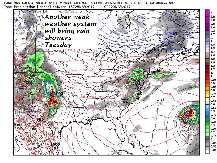
TOMORROW: Cloudy. Light rain showers likely. Much milder. A high in the upper 40s to low 50s. Light winds.

TUESDAY NIGHT: Chance for light rain showers diminishing overnight. A low near 32. Light north winds.

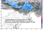
WEDNESDAY: Clouds mixing with breaks of afternoon sunshine. Scattered rain showers mixing with wet snow flakes Barre-Montpelier area north with minor accumulation. A high 35 to 40. North to northwest winds 10 to 20 mph.

Looking Further ahead…

WEDNESDAY NIGHT: Chance for an evening mountain flurry, then gradual clearing. A low mid teens to mid 20s.

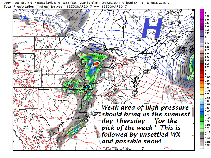
THURSDAY: Pick of the week. Sunny in the morning, giving way to high cloudiness in the afternoon. A high close to 40.

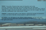
FRIDAY: Gray. Chance for wet snow or snow showers. A few inches of accumulation. A low in the mid 20s. A high around 32.

SATURDAY: Cloudy. Chance for wet snow early, tapering to scattered snow showers or flurries. Several inches of accumulation. A low in the upper 20s. A high around 35.

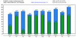
Average lows in the mid 20s. Normal highs in the mid 40s

RH/3-27[end]

Updated Monday morning Forecast

March 27th, 2017

Freezing Rain Advisory through 11 AM this Monday morning…

TODAY: Gray. Pockets of freezing rain east of the Green Mountains with treacherous travel in spots through mid morning. Periods of light rain gradually tapering to showers this afternoon. Areas of fog with a high in the mid to upper 30s. Light southeast winds.

TONIGHT: Mainly cloudy. Slight chance for a rain shower or sprinkle. A low in the mid 30s. Light winds.

TUESDAY: Cloudy. Light rain showers likely. Much milder. A high in the upper 40s to low 50s. Light southwest winds.

Looking Further ahead…

TUESDAY NIGHT: Chance for light rain showers diminishing overnight. A low near 32.

WEDNESDAY: Intervals of sunshine mixed with clouds. Scattered mixed rain or snow showers northern areas. A high 35 to 40.

THURSDAY: Pick of the week. Sunny and gorgeous. Some late day high cloudiness. A low in the teens. A high in the low 40s.

FRIDAY: Thickening clouds. Periods of light wet snow or snow showers with some minor accumulation. A low around 20. A high in the low to mid 30s.

SATURDAY: Cloudy and gray. Periods of wet snow early, tapering to scattered snow showers or flurries. Accumulation up to locally 5” in the mountains.

Average lows in the low to mid 20s. Normal highs in the low to mid 40s

RH/3-27[end]

updated Friday evening forecast

March 24th, 2017

TONIGHT: Periods of wet snow moderate at times through mid evening…tapering off after midnight. Additional accumulation 1 to 2 inches. Temperatures rising into the low 30s this evening. Light north winds.

TOMORROW: Any wet snow or rain showers toward Rutland, exiting in the morning. Otherwise increasing afternoon sunshine northern areas. A high near 40. Light north winds.

SATURDAY NIGHT: Mostly clear and cold. A low 5 to 15. Light northeast winds.

SUNDAY: Morning sun, then clouding up in the afternoon. Slight chance for a rain showers late. A high 40 to 45. (Maybe a sap run) Light southeast winds.

Looking Further ahead…

SUNDAY NIGHT: Scattered light rain showers with pockets of freezing rain east of the Green Mountains producing slick travel. A low near 32.

MONDAY: Gray. Pockets of freezing rain early then periods of rain, areas of fog. A high in the mid 30s.

TUESDAY: Cloudy. Spotty mixed precipitation in the morning with slick travel possible, changing to rain showers. A low near 32. A high 45 to 50.

WEDNESDAY: Intervals of sunshine mixed with clouds. A low around 25. A high 40 to 45.

Average lows 20 to 25. Normal highs 40 to 45.

RH/3-24[end]

Updated Friday morning forecast

March 24th, 2017

TODAY: Gray skies. Periods of wet snow arriving this mid to late morning…eventually mixing with rain most valley floors this afternoon. Accumulation a slushy inch valley floors, to locally 5”inches wet snow above 1500 to 1800 feet. A high in the low to mid 30s northern areas, but mid to upper 30s South of the Barre-Montpelier area. South winds 10 mph.

TONIGHT: Scattered wet snow or rain showers, mainly this evening. Accumulation a trace to an inch in the hills. A low around 32. Light north winds.

SATURDAY: Any wet snow or rain showers toward Rutland, exiting south early Otherwise increasing afternoon sunshine developing northern areas. A high near 40. Light north winds.

Looking Further ahead…

SATURDAY NIGHT: Mostly clear and cold. A low 5 to 15.

SUNDAY: Morning sunshine gives way to increasing clouds in the afternoon. A rising chance for a rain showers with pockets of freezing rain toward evening making for slick travel.. A high 40 to 45. (Maybe a sap run)

MONDAY: Gray. Chance of a light wintry mix producing slick travel in the morning. Rain showers or mixed precip in the afternoon. A low around 30. A high in the mid 30s.

TUESDAY: Cloudy. Spotty mixed precipitation in the morning with slick travel possible, changing to rain showers. A low near 32. A high around 40.

WEDNESDAY: Cloudy with a chance for rain or mixed precipitation. A low around 30. A high mid 30s to near 40.

Average lows 20 to 25. Normal highs 40 to 45.

RH/3-23[end]

Updated Thursday Evening Forecast

March 23rd, 2017

TONIGHT: Increasing high clouds this evening thickening overnight. A low 10 to 15. Little wind.

TOMORROW: Gray skies. Periods of wet snow eventually mixing with rain south of the Barre-Montpelier area in the afternoon. Accumulation 2 to locally 5”inches wet slushy snow. A high in the mid 30s. South winds 10 to 15 mph.

FRIDAY NIGHT: Wet snow showers north of the Barre-Montpelier area with rain showers south mixing with wet snow. A low around 30. Light northwest winds.

SATURDAY: Any wet snow showers exit early to partial afternoon sunshine. A high 35 to 40. Light north winds.

Looking Further ahead…

SATURDAY NIGHT: Mostly clear and cold. A low 5 to 15.

SUNDAY: Morning sunshine gives way to increasing high clouds in the afternoon. A rising chance for a wintry mix developing late. A high 40 to 45. (Maybe a sap run)

MONDAY: Gray. Chance of a light wintry mix producing slick travel in the morning. Rain showers or mixed precip in the afternoon. A low around 30. A high in the mid 30s.

TUESDAY: Cloudy. Spotty mixed precipitation in the morning with slick travel possible, changing to rain showers. A low near 32. A high around 40.

WEDNESDAY: Cloudy with a chance for rain or mixed precipitation. A low around 30. A high mid 30s to near 40.

Average lows 20 to 25. Normal highs 40 to 45.

RH/3-23[end]

Updated Thursday morning forecast —

March 23rd, 2017

TODAY: Sunshine becoming filtered through high clouds. A high in the mid 20s. Northwest winds 10 to 15 mph.

TONIGHT: Increasing and thickening clouds. A low near 10. Little wind.

FRIDAY: Gray skies. Periods of wet snow eventually mixing with rain south of the Barre-Montpelier area in the later afternoon. About 2 to locally 5”inches wet slushy accumulation. A high 32 to 35. South winds 10 to 15 mph.

Looking Further ahead…

FRIDAY NIGHT: Wet snow showers north of the Barre-Montpelier area with rain showers south mixing with wet snow. A low around 30.

SATURDAY: Chance for wet snow showers early with up to an inch accumulation. Partly sunny skies in the afternoon central and northern areas. Temperatures falling into the upper 20s into the afternoon.

SUNDAY: Morning sunshine gives way to increasing high clouds in the afternoon. A wintry mix develops Sunday night with poor travel. A low around 32. A high in the upper 30s to low 40s.

MONDAY: Gray. Periods of light wintry mix producing slick travel. A low around 30. A high in the mid 30s.

TUESDAY: Spotty mixed precipitation in the morning with slick travel possible, changing to scattered rain showers. A low near 32. A high in the low to mid 40s

Average lows 20 to 25. Normal highs 40 to 45.

RH/3-23[end]

Updated Wednesday Evening Forecast

March 22nd, 2017

TONIGHT: Clear and cold. A low 5 below to 10 above. Northwest winds 10 mph becoming light.

TOMORROW: Sunshine becoming filtered through high clouds. A high in the mid 20s. Northwest winds 10 to 15 mph.

THURSDAY NIGHT: Increasing and thickening clouds. A low near 10. Little wind.

FRIDAY: Gray skies. Periods of wet snow mixing with rain south of the Barre-Montpelier area in the later afternoon. About 2 to locally 5”inches wet slushy accumulation. A high in the low to mid 30s. South winds 10 to 15 mph.

Looking Further ahead…

FRIDAY NIGHT: Wet snow showers north of the Barre-Montpelier area with rain showers south mixing with wet snow. A low around 30.

SATURDAY: Considerable cloudiness after wet snow showers exiting in the morning. Additional accumulation an inch or so. Temperatures falling into the upper 20s late.

SUNDAY: Intervals of morning sunshine, then more clouds in the afternoon. A chance for a wintry mix with hazardous travel in the evening. A low around 32. A high in the upper 30s

MONDAY: Gray with periods of light wintry mix producing slick travel. A low around 30. A high around 35.

TUESDAY: Spotty mixed precipitation in the morning with slick travel possible, changing to scattered rain showers. A low 30 to 35. A high 35 to 40.

Average lows 20 to 25. Normal highs 40 to 45.

RH/3-22[end]

Wednesday morning Weather

March 22nd, 2017

TODAY: Snow showers & squalls wind down this morning to a few leftover flurries then exiting. Little additional accumulation. Periods of sunshine this afternoon, blustery, sharply colder. Temperatures in the teens. Gusty northwesterly winds 10 to 25 mph…with higher gusts lowering wind chills.

TONIGHT: Clear and cold. A low 5 below to 10 above. Northwest winds 10 mph becoming light.

THURSDAY: Sunshine becoming filtered through high clouds. A high in the mid 20s. Northwest winds 10 mph.

Looking Further ahead…

THURSDAY NIGHT: Increasing and thickening clouds. A low near 10.

FRIDAY: Gray with periods of snow. About 2 to locally 5”inches accumulation by dark. A high in the low 30s.

SATURDAY: Mainly cloudy. Occasional light wet snow or snow showers. Additional accumulation 1 to 2”. A low near 30. A high around 40.

SUNDAY: Slight chance for a leftover flurry early, then intervals of sunshine. A low around 10 above. A high in the 35 to 40.

MONDAY: Gray with periods of light accumulating snow. L:ows in the 20s. A high 30 to 35.

Average lows 20 to 25. Normal highs 40 to 45.

RH/3-22[end]

Updated Tuesday evening Forecast

March 21st, 2017

TONIGHT: Becoming partly cloudy to mostly clear for a time this evening. Skies cloud up before midnight. Snow showers or squalls developing overnight. A dusting to a couple of inches, with most in the northern Greens. A low 10 to 15. Northwesterly winds pick up 10 to 25 mph overnight.

TOMORROW: A morning snow squall or snow shower. Accumulating under an inch. Blustery, sharply colder. A high in the upper teens. Gusty northwesterly winds 10 to 25 mph lowering wind chills.

WEDNESDAY NIGHT: Clear and cold. A low 5 below to 10 above. Northwest winds 10 mph becoming light.

THURSDAY: Sunshine becoming filtered through high clouds. A high in the mid 20s. Light northwest winds.

Looking Further ahead…

THURSDAY NIGHT: Thickening clouds. A low near 10.

FRIDAY: Cloudy and gray. Occasional light snow. About an inch or two accumulation by dark. A high in the low 30s.

SATURDAY: Mainly cloudy. Chance for a mountain flurry or sprinkle southern areas. A low near 30. A high around 40.

SUNDAY: Lots of clouds. Chance for a wintry mix in the afternoon. Temperatures in the upper 20s to upper 30s.

Average lows 20 to 25. Normal highs 40 to 45.

RH/3-21[end]

Updated Tuesday morning forecast —

March 21st, 2017

TODAY: Considerable cloudiness. Widely scattered wet snow or rain showers mainly northern areas arriving later this morning into the afternoon. Little if any accumulation. Breaks or intervals of sunshine possible late. A high in the upper 30s to mid 40s maybe a sap run. Light southwest winds.

TONIGHT: Fair or partly cloudy in the evening then clouding up. Good chance for a snow shower or snow squall. A dusting to a couple of inches especially near the Green Mountains. A low in the teens. Northwesterly winds becoming 10 to 25 mph overnight.

WEDNESDAY: A morning snow squall or snow shower exiting in the afternoon with dusting to an inch. Blustery, sharply colder. A high in the upper teens to lower 20s. Gusty northwesterly winds 10 to 25 mph lowering wind chills.

Looking Further ahead…

WEDNESDAY NIGHT: Clear and cold. A low 5 below to 10 above.

THURSDAY: Sunshine becoming filtered through high clouds. A high in the mid 20s.

FRIDAY: A little sun in the morning, then thickening clouds. leading to a scattered light accumulating snow showers with minor accumulation. A low 5 to 10. A high near 35.

SATURDAY: Mainly cloudy. Chance for a mountain snow shower or valley flurry southern half of Vermont. A low near 25. A high in the ranging mid 30s to low 40s.

Average lows 20 to 25. Normal highs 40 to 45.

RH/3-21[end]