
March 24th, 2017
-
- image00118
-
- image00218
-
- image00314
-
- image0047
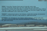
TODAY: Gray skies. Periods of wet snow arriving this mid to late morning…eventually mixing with rain most valley floors this afternoon. Accumulation a slushy inch valley floors, to locally 5”inches wet snow above 1500 to 1800 feet. A high in the low to mid 30s northern areas, but mid to upper 30s South of the Barre-Montpelier area. South winds 10 mph.
TONIGHT: Scattered wet snow or rain showers, mainly this evening. Accumulation a trace to an inch in the hills. A low around 32. Light north winds.
SATURDAY: Any wet snow or rain showers toward Rutland, exiting south early Otherwise increasing afternoon sunshine developing northern areas. A high near 40. Light north winds.
Looking Further ahead…
SATURDAY NIGHT: Mostly clear and cold. A low 5 to 15.
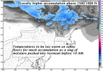
SUNDAY: Morning sunshine gives way to increasing clouds in the afternoon. A rising chance for a rain showers with pockets of freezing rain toward evening making for slick travel.. A high 40 to 45. (Maybe a sap run)
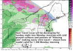
MONDAY: Gray. Chance of a light wintry mix producing slick travel in the morning. Rain showers or mixed precip in the afternoon. A low around 30. A high in the mid 30s.
TUESDAY: Cloudy. Spotty mixed precipitation in the morning with slick travel possible, changing to rain showers. A low near 32. A high around 40.
WEDNESDAY: Cloudy with a chance for rain or mixed precipitation. A low around 30. A high mid 30s to near 40.
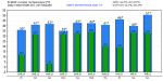
Average lows 20 to 25. Normal highs 40 to 45.
RH/3-23[end]
