Updated Tuesday night Forecast — April 4th, 2017

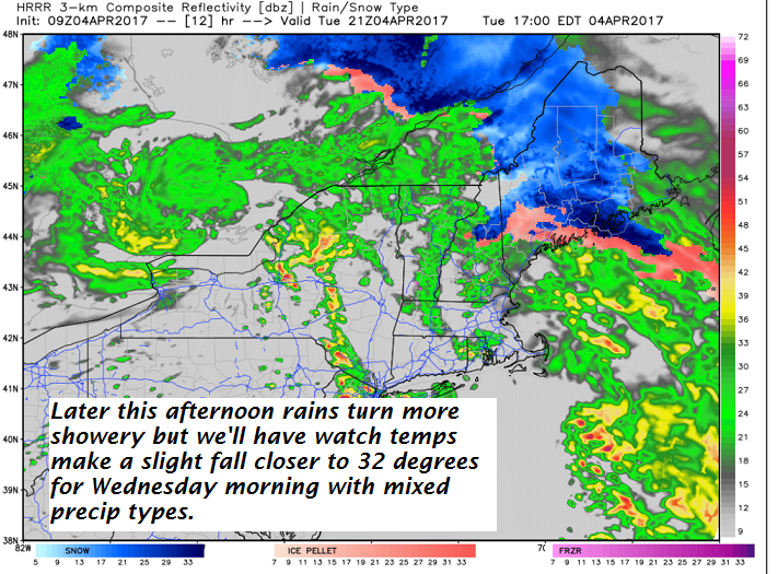
TONIGHT: Periods of rain…transitions into a wintry mix east of the Green Mountains overnight. Watch for slick spots developing late this evening and overnight. A low tonight 32 to 35. Southeast winds 10 to 15 mph.

TOMORROW: Scattered rain or mixed precipitation producing slick travel in some areas early. Scattered light rain showers or sprinkles exiting in the afternoon. A high near 45. Possible sap run. Light west winds.

WEDNESDAY NIGHT: Fair early, then thickening clouds leading to a chance for more mixed precipitation later overnight. Gusty winds western slopes of Greens. A low in the low 30s. Light northwest winds.

THURSDAY: Periods of rain, moderate possibly heavy for a times.. A high 40 to 45. Gusty winds western slopes of Greens from the southeast 10 to 20 mph.

Looking Further ahead…

THURSDAY NIGHT: Fair early then clouding up. A low 35 to 40.

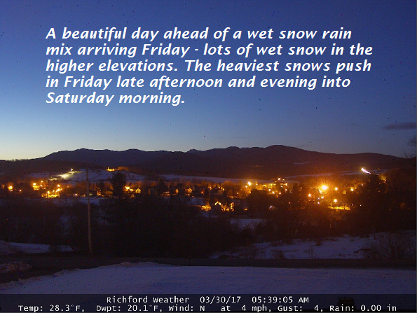
FRIDAY: Scattered light rain showers or sprinkles. Maybe an interval of afternoon sunshine. A high in the mid 40s.

SATURDAY: Scattered snow showers, perhaps a dusting to an inch in the morning, Otherwise mostly cloudy. A low around 32. A highs in the upper 30s.

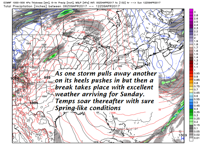
SUNDAY: Mostly sunny, gorgeous and spring-like temperatures. A low 20 to 25. A high in the mid 50s.

MONDAY: Sunshine becoming filtered through high clouds. A low 35 to 40. A high in the low 70s.

Average lows in the upper 20s to around 30. Normal highs in the upper 40s to low 50s

RH/4-4[end]

Updated Tuesday morning Forecast — April 4th, 2017

TODAY: Cloudy. Periods of rain, Watch for an isolated slick spots due to sub-freezing ground temperatures for a brief period this morning. Periods of rain this afternoon. Gusty winds western slopes of the Greens. Southeast wind 10 to occasionally 20 mph.

TONIGHT: Periods of rain…transition into a wintry mix east of the Green Mountains overnight with poor traveling due to slick spots developing. A low tonight 32 to 35. Southeast winds 10 to 15 mph.

WEDNESDAY: Scattered rain or mixed precipitation producing slick travel in some areas early. Scattered light rain showers or sprinkles exiting in the afternoon. A high 40 to 45. Possible sap run. Light west winds.

Looking Further ahead…

WEDNESDAY NIGHT: Fair early, then thickening clouds leading to a chance for more mixed precipitation later overnight. Gusty winds western slopes of Greens. A low in the low 30s.

THURSDAY: Periods of rain, moderate at times. Gusty winds western slopes of Greens. A high in the mid to upper 30s.

FRIDAY: Scattered light rain showers or sprinkles. Maybe an intervals of afternoon sunshine. A low around 35. A low in the low to mid 40s.

SATURDAY: Scattered snow showers, perhaps a dusting to an inch in the morning, Otherwise mostly cloudy. A low around 30. A highs in the mid to upper 30s.

SUNDAY: Mostly sunny, gorgeous and spring-like temperatures. A low in the 20s. A high in the 50s.

MONDAY: Sunshine becoming filtered through high clouds. A low in the 30s. A high in the mid 70s.

Average lows in the upper 20s to around 30. Normal highs in the upper 40s to low 50s

RH/4-4[end]

Updated Friday Evening forecast March 31st, 2017

Winter Storm Warning Caledonia to Washington county Eastern Addison County south in effect through 2 PM Saturday. Winter Weather Advisories elsewhere.

TONIGHT: Cloudy. Snow or wet snow…moderate to heavy at times with poor travel. Possible tree damage and power outages due to heavy wet snowfall. A low in the upper 20s. Southeast winds 10 to occasionally 20 mph.

TOMORROW: Cloudy. Snow or wet snow moderate to heavy at times in the morning. Possible tree damage and power outages due to heavy wet snowfall. Snowfall becoming much lighter in the afternoon. Total accumulation about 6 to 16” with most higher summits of the Greens. A high in the mid 30s.Light northeast winds.

SATURDAY NIGHT: Occasional light snow or snow showers winding down overnight with minor accumulation. A low in the upper 20s. Light northwest winds.

SUNDAY: Partly sunny. A high near 45 with sap run likely. Northwest winds 10 to 15 mph.

Looking Further ahead…

SUNDAY NIGHT: Scattered clouds or mostly clear. A low 10 to 15

MONDAY: Filtered sunshine through high clouds. with a high around 45. Sap run likely.

TUESDAY: Cloudy. A chance for wet snow, rain mix. A few to several inches possible. A low in the 20s. A high in the mid 30s.

WEDNESDAY: Chance for wet snow showers early then exiting with partial afternoon clearing. A low in the 20s. with a high in the mid 40s. Possible sap run.

Average lows in the mid to upper 20s. Normal highs in the mid to upper 40s

RH/3-31[end]

Updated Friday morning Forecast — March 31st 2017

Winter Storm Warning Caledonia to Washington county Eastern Addison County south in effect through 2 PM Saturday. Winter Weather Advisories elsewhere.

TODAY: Gray. Periods of wet snow…possibly mixed with rain valley floors…developing mid day making for slick slushy travel. Slushy accumulation of dusting to an inch Northeast Kingdom, 2 to locally 4” Barre-Montpelier area and 3 to 6” toward Rutland. Temperatures peak 32 to 35. Southeast winds 10 to occasionally 20 mph.

TONIGHT: Cloudy. Snow or wet snow…moderate to heavy at times with poor travel. Possible tree damage and power outages due to heavy wet snowfall. A low in the upper 20s. Southeast winds 10 to occasionally 20 mph.

SATURDAY: Cloudy. Snow or wet snow moderate to heavy at times in the morning. Possible tree damage and power outages due to heavy wet snowfall. Snowfall becoming much lighter in the afternoon. Total accumulation about 6 to 16” with most higher summits of the Greens. A high in the mid 30s.Light northeast winds.

Looking Further ahead…

SATURDAY NIGHT: Occasional light snow or snow showers winding down overnight with minor accumulation. A low in the upper 20s.

SUNDAY: Partly sunny. A high near 45 with sap run likely.

MONDAY: Filtered sunshine through high clouds. A low 10 to 15 with a high around 45. Sap run likely.

TUESDAY: Cloudy. A chance for wet snow, rain mix. A few to several inches possible. A low in the 20s. A high in the mid 30s.

WEDNESDAY: Chance for wet snow showers early then exiting with partial afternoon clearing. A low in the 20s. with a high in the mid 40s. Possible sap run.

Average lows in the mid to upper 20s. Normal highs in the mid to upper 40s

RH/3-31[end]

Roger Hill

Weathering Heights Consulting

186 MacKenzie Dr.

Worcester VT 05682

updated Thursday Evening forecast — March 30th, 2017

Winter Storm Warning Caledonia to Washington county south through 2 PM Saturday. Winter Weather Advisories N tier and Champlain Valley south into western Rutland county.

TONIGHT: Fair early, giving way to thickening clouds. A rising chance for very light snow or flurries toward Rutland – Randolph around or before daybreak. A low 20 to 25. Light wind.

TOMORROW: Gray. Periods of wet snow…possibly mixed with rain valley floors…developing before mid day making for slick slushy travel. Slushy accumulation of dusting to an inch Northeast Kingdom, 2 to locally 4” Barre-Montpelier area and 4 to 8” toward Rutland. Temperatures peak 32 to 35. Southeast winds 10 to occasionally 20 mph.

FRIDAY NIGHT: Cloudy. Snow or wet snow…moderate to heavy at times with poor travel and possible tree damage and power outages. A low in the upper 20s. Southeast winds 10 to occasionally 20 mph.

SATURDAY: Cloudy. Snow or wet snow moderate to heavy at times in the morning. Light snow in the afternoon . Total accumulation about 6 to 16” with locally more central and southern Green Mountains summits. A high in the mid 30s.Light northeast winds.

Looking Further ahead…

SATURDAY NIGHT: Occasional light snow or snow showers winding down overnight with minor accumulation. A low in the upper 20s.

SUNDAY: Partly sunny. A high 40 to 45.

MONDAY: Filtered sunshine through high clouds. A low in the single digits with a high near 40.

TUESDAY: Cloudy with a chance for wet snow. A low in the 20s. A high in the low 30s.

Average lows in the mid 20s. Normal highs in the mid 40s

RH/3-30[end]

Updated Thursday morning Forecast —

March 30th, 2017

TODAY: Pick of the week. Mostly sunny. Some high clouds southern areas this afternoon. A high near 40. Northwest winds 10 mph.

Winter Weather Advisories N half of Vermont. Winter Storm Warning and Watches south go into effect early tomorrow morning through 2 PM Saturday.

TONIGHT: Fair early, giving way to thickening clouds. A rising chance for very light snow or flurries toward Rutland – Randolph around or before daybreak. A low 20 to 25. Light wind.

FRIDAY: Gray. Periods of wet snow…possibly mixed with rain valley floors…developing before mid day making for slick slushy travel. Slushy accumulation of dusting to an inch Northeast Kingdom, 2 to locally 4” Barre-Montpelier area and 4 to 8” toward Rutland. Temperatures peak 32 to 35. Southeast winds 10 to occasionally 20 mph.

Looking Further ahead…

FRIDAY NIGHT: Cloudy. Periods of snow…moderate…possibly heavy at times southern Vermont. A low upper 20s to around 30.

SATURDAY: Cloudy. Snow or wet snow in the morning. Occasional snow showers and flurries continuing into the afternoon. Total accumulation about 4 to 10” with 6 to 14” high elevations central and S. Vermont. A high in the mid 30s.

SUNDAY: Partly sunny. A low 20 to 25. A high in the in upper 30s to low 40s.

MONDAY: Filtered sunshine through high clouds. A low in the single digits with a high near 40.

TUESDAY: Chance for a few sprinkles or flurries. A low in the 20s. A high in the upper 30s.

Average lows in the mid 20s. Normal highs in the mid 40s

RH/3-30[end]

Updated Wednesday Evening forecast

March 29th, 2017

TONIGHT: Mostly cloudy. An occasional flurry early this evening, then clearing skies. A low in the teens. Northwest winds 10 mph.

TOMORROW: Pick of the week. Sunny crisp morning gives way to high clouds late in the afternoon. A high near 40. Northwest winds 10 mph.

Winter Storm Watch Late Thursday night through Saturday Afternoon E. Addison, Windsor and Rutland County

THURSDAY NIGHT: Fair early giving way to thickening clouds. A rising chance for very light snow or flurries toward Rutland around daybreak. A low 20 to 25. Light wind.

FRIDAY: Gray. Periods of wet snow developing before mid day making for slick travel. Slushy accumulation of dusting to an inch Northeast Kingdom, 2 to locally 4” Barre-Montpelier area and 4 to 8” toward Rutland. A high close to 32. Southeast winds 10 to occasionally 20 mph.

Looking Further ahead…

FRIDAY NIGHT: Cloudy. Periods of snow…moderate at times. A low upper 20s.

SATURDAY: Cloudy. Snow or wet snow in the morning. Occasional snow showers and flurries continuing into the afternoon. Total accumulation about 4 to 10” with the most in the higher elevations especially central and S. Vermont. A high in the mid 30s.

SUNDAY: Partly sunny. A low 20 to 25. A high in the in upper 30s to low 40s.

MONDAY: Filtered sunshine through high clouds. A low in the single digits with a high near 40.

TUESDAY: Chance for a few sprinkles or flurries. A low in the 20s. A high in the upper 30s.

Average lows in the mid 20s. Normal highs in the mid 40s

RH/3-29[end]

Updated Wednesday morning forecast —

March 29th, 2017

TODAY: Clouds mixing with breaks of afternoon sunshine. Widely scattered wet snow showers northern heights of land with a skiff of accumulation possible. A high mid to upper 30s. North to northwest winds flare up 10 to 20 mph this afternoon.

TONIGHT: Chance for a flurry early, then clearing. A low in the teens. Northwest winds 10 mph.

THURSDAY: Pick of the week. Sunny in the morning, giving way to high cloudiness late. A high near 40. Northwest winds 10 mph.

Looking Further ahead…

THURSDAY NIGHT: Fair early giving way to thickening clouds. A rising chance for very light snow or flurries developing around daybreak. A low 20 to 25.

FRIDAY: Gray. Snow or wet snow likely. Accumulations of a few to several inches making for slick travel. A high 32 to 35.

SATURDAY: Cloudy. Snow or wet snow likely with several additional inches…exiting as snow showers or flurries Saturday late afternoon. Total accumulations about 6 to 12”. A low upper 20s to about 30. A high 35 to 40.

SUNDAY: Partly to mostly sunny. A low 20 to 25. A high in the in upper 30s to low 40s.

MONDAY: Lots of sunshine with a few high clouds. A low in the single digits with a high near 40.

Average lows in the mid 20s. Normal highs in the mid 40s

RH/3-29[end]

Updated Tuesday Evening forecast —

March 28th, 2017

TONIGHT: Cloudy. Scattered evening rain showers exiting overnight. A low near 32. Light north winds.

TOMORROW: Clouds mixing with breaks of afternoon sunshine. Scattered rain showers mixing with wet snow flakes Barre-Montpelier area north with minor accumulation. A high in the mid to upper 30s. North to northwest winds 10 to 20 mph.

WEDNESDAY NIGHT: Chance for an evening mountain flurry, then clearing. A low 10 to 20 degrees. Northwest winds 10 mph.

THURSDAY: Pick of the week. Sunny in the morning, giving way to high cloudiness late. A high around 40. Northwest winds 10 mph.

Looking Further ahead…

THURSDAY NIGHT: Fair early giving way to thickening clouds. A low in the mid 20s.

FRIDAY: Gray. Wet snow becoming likely with a few inches of accumulation making for slick travel. A high around 32.

SATURDAY: Cloudy. Chance for wet snow early, tapering to scattered snow showers or flurries. Total accumulations could be hefty with several; or more inches possible. A low in the mid to upper 20s. A high 35 to 40.

SUNDAY: Partly to mostly sunny. A low around 20. A high in the in upper 30s to around 40.

MONDAY: Lots of sunshine with a few high clouds. A low in the single digits with a high around 40.

Average lows in the mid 20s. Normal highs in the mid 40s

RH/3-28[end]

Updated Tuesday morning Forecast —

March 28th, 2017

Down Under —

Tropical Cyclone Debbie was bearing down on the coast of Queensland, Australia, Monday afternoon local time.

As of 10 p.m. Australian Eastern Standard Time (1200 UTC), maximum winds near the center of circulation were sustained at 110 mph, making it a Category 4 on Australia’s tropical cyclone category system. Debbie is forecast to make landfall near Bowen as a Category 4 tropical cyclone around 9:00 a.m. local time on Tuesday. However, conditions will deteriorate throughout Monday night between Bowen and Mackay.

Back in Vermont – A mild push but also dreary conditions…

TODAY: Cloudy. Scattered rain showers. Much milder. A high in the upper 40s to low 50s. Light winds.

TONIGHT: Cloudy. A round of evening rain showers exiting overnight. A low near 32. Light north winds.

WEDNESDAY: Clouds mixing with breaks of afternoon sunshine. Scattered rain showers mixing with wet snow flakes Barre-Montpelier area north with minor accumulation. A high 35 to 40. North to northwest winds 10 to 20 mph.

Looking Further ahead…

WEDNESDAY NIGHT: Chance for an evening mountain flurry, then clearing. A low 10 to 20 degrees.

THURSDAY: Pick of the week. Sunny in the morning, giving way to high cloudiness in the afternoon. A high close to 40.

FRIDAY: Gray. Chance for wet snow or snow showers with a few inches of accumulation. A low in the mid 20s. A high around 32.

SATURDAY: Cloudy. Chance for wet snow early, tapering to scattered snow showers or flurries. Several inches of accumulation possible. A low in the upper 20s. A high around 35.

Average lows in the mid 20s. Normal highs in the mid 40s

RH/3-27[end]