
March 22nd, 2017
-
- image00117
-
- image00216
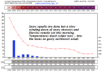
TODAY: Snow showers & squalls wind down this morning to a few leftover flurries then exiting. Little additional accumulation. Periods of sunshine this afternoon, blustery, sharply colder. Temperatures in the teens. Gusty northwesterly winds 10 to 25 mph…with higher gusts lowering wind chills.
TONIGHT: Clear and cold. A low 5 below to 10 above. Northwest winds 10 mph becoming light.
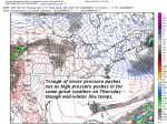
THURSDAY: Sunshine becoming filtered through high clouds. A high in the mid 20s. Northwest winds 10 mph.
Looking Further ahead…
THURSDAY NIGHT: Increasing and thickening clouds. A low near 10.
FRIDAY: Gray with periods of snow. About 2 to locally 5”inches accumulation by dark. A high in the low 30s.
SATURDAY: Mainly cloudy. Occasional light wet snow or snow showers. Additional accumulation 1 to 2”. A low near 30. A high around 40.
SUNDAY: Slight chance for a leftover flurry early, then intervals of sunshine. A low around 10 above. A high in the 35 to 40.
MONDAY: Gray with periods of light accumulating snow. L:ows in the 20s. A high 30 to 35.
Average lows 20 to 25. Normal highs 40 to 45.
RH/3-22[end]
