Updated Monday Evening forecast — January 30th, 2017

TONIGHT: Mostly clear and cold. A low in the single digits. Light west winds.

TOMORROW: Partly sunny. A high in the mid 20s. Light southwest winds.

TUESDAY NIGHT: Increasing and thickening clouds leading to periods of light snow or snow showers with a dusting to an inch accumulation. A low in the mid to upper teens. Light winds.

WEDNESDAY: Periods of light accumulating snow likely with around 1 to 3” accumulation. A high in the upper 20s to around 30. West breeze 10 mph.

Looking Further ahead…

WEDNESDAY NIGHT: A low in the single digits.

THURSDAY: Partly sunny. Chance for a mountain flurry. A high in the low 20s.

FRIDAY: Mostly cloudy. Maybe a late day flurry. A low zero to 5 above. A high near 20.

SATURDAY: Partly sunny with scattered flurries. A low zero to 5 above. A high around 20.

SUNDAY: Partly sunny. A low 5 below to 5 above. A high in the low 20s.

Average lows in the mid to upper single digits. Normal highs in the mid 20s to around 30.

RH/1-30[end]

Update Monday morning Forecast & WX Notes — January 30th, 2017

· 50/50 kind of day today with a few flurries flaring…but improvement as flow changes from down-wind of Great Lakes cutting off lake effects clouds and snowflakes to mostly clear skies tonight.

· Tomorrow – decent winter day watching the first of two weather systems train first to our south, and the second through our region arriving late Tuesday night and mostly Wednesday.

· Above is Wednesday early afternoon precipitation type in a all snow J.

· We in Vermont, have by decree not allowed any immigrating rain drops until fully vetted through the middle part of next month, but all forms of normal nice well being humans are acceptable – especially those persecuted. And we favor snow-lovers over those of warm weather 😉

· Below is Euro ensemble project for the next 7 days for snow accrual.

TODAY: Clouds mixed with periods of sunshine. Widely scattered flurries especially mid day. A high in the lower 20s. Northwest winds around 10 mph.

TONIGHT: Mostly clear and cold. A low 5 to 10. Light west winds.

TUESDAY: Partly sunny. A high in the mid 20s. Light southwest winds.

Looking Further ahead…

TUESDAY NIGHT: Increasing and thickening clouds leading to periods of light snow or snow showers with a dusting to an inch accumulation. A low 20 to 25.

WEDNESDAY: Periods of light accumulating snow likely with around 1 to 3” accumulation. A high in the upper 20s to around 30.

THURSDAY: Partly sunny. Chance for a mountain flurry. A low around 10. A high in the low 20s.

FRIDAY: Mostly cloudy. Maybe a late day flurry. A low around 5 above. A high 15 to 20.

SATURDAY: Partly sunny. Chance for a flurry. A low around 5 above. A high in the mid to teens to around 20.

SUNDAY: Partly sunny. A low in the single digits below zero. A high in the 20s.

Average lows in the mid to upper single digits. Normal highs in the mid 20s to around 30.

RH/1-30[end]

Updated Friday Evening forecast — January 20th, 2017

TONIGHT: Cloudy. A low in the upper 20s to around 32. Light south winds.

TOMORROW: Clouds…maybe a few breaks or intervals of sun. Isolated sprinkles northern areas. A high upper 30s to low 40s. Light southwest winds.

SATURDAY NIGHT: Lots of clouds. Scattered flurries or sprinkles northern areas. A low 30 to 35. Little wind.

SUNDAY: Clouds with a few breaks of sun possible. Widely scattered sprinkles mixed with a few wet snow flakes. A high in the mid to upper 30s. Light southwest winds.

Looking Further ahead…

SUNDAY NIGHT: Mainly cloudy. A low near 30.

MONDAY: Cloudy. Good chance for a “wintry mix” of precipitation overspreading from south to north in the afternoon. Hazardous travel increasingly likely by late in the day.. A high near 32.

TUESDAY: Wintry mix with poor travel conditions. Moderate accumulation of sleet and wet snow possible. A low 25 to 30. A high around 32.

WEDNESDAY: Chance of snow showers in the morning with partial afternoon sunshine. A low near 25. A high around 35.

THURSDAY: Mostly cloudy. Chance for a rain or snow shower. A low in the low 30s. A high in the upper 30s to around 40.

Average lows in the single digits. Normal highs in the 20s. Midpoint of meteorological winter – Jan. 23rd.

RH/1-20[end]

Updated Friday morning Forecast & WX notes — January 20th, 2017

· Uneventfull through Monday morning, the rest of today will be a struggle to break up clouds but they are doing so this morning.

· Below temperature inversion schematic from modeled temperature profiles in the lowest part of the atmosphere.

· In the past, when temperatures inversion rise avbove mountain levles rouhgly 4500 or higher clouds eventually break up.

· And today in Moscow – highs above 32 degrees.

· Major protest Saturday at the Nation’s capitol and locally look fair and dry.

TODAY: Mainly cloudy this morning, then partial afternoon sunshine away from the Green Mountains. A high in the mid to upper 30s – Maybe a sap run. Light southeast winds.

TONIGHT: Cloudy. A low in the mid 20s to around 30. Light south winds.

SATURDAY: Partly to mostly cloudy. Isolated sprinkles northern areas. A high 35 to around 40. Light southwest winds.

Looking Further ahead…

SATURDAY NIGHT: Lots of clouds. Scattered flurries or sprinkles northern areas. A low around 30.

SUNDAY: Clouds mixed with sun. Slight chance for a flurry or valley sprinkle. A high in the mid 30s.

MONDAY: Cloudy. Good chance for a “wintry mix” of precipitation overspreading from south to north in the afternoon. Hazardous travel increasingly likely by late in the day. A low 25 to 30. A high in the low 30s.

TUESDAY: Wintry mix with poor travel conditions. Moderate accumulation of sleet and wet snow possible. A low around 25. A high in the low 30s.

WEDNESDAY: Chance of snow showers in the morning with partial afternoon clearing. A low 20 to 25. A high near 32.

Average lows in the single digits. Normal highs in the 20s. Midpoint of meteorological winter – Jan. 23rd.

RH/1-20[end]

Updated Thursday Evening forecast — January 19th, 2017

TONIGHT: Mostly cloudy. A low around 25. Little wind.

TOMORROW: Pick of the week – A few morning clouds, otherwise lots of sunshine. A high around 40 – Maybe a sap run. Light southeast winds.

FRIDAY NIGHT: Increasing clouds. A low in the mid 20s. Light south winds.

SATURDAY: More clouds than sun. Isolated sprinkles northern areas. A high in the low 40s – Maybe a sap run. Light southwest winds.

Looking Further ahead…

SATURDAY NIGHT: Lots of clouds. Scattered flurries or sprinkles northern areas. A low around 30.

SUNDAY: Clouds mixed with sun. Slight chance for a flurry or valley sprinkle. A high in the mid 30s.

MONDAY: Cloudy. Good chance for a “wintry mix” of precipitation overspreading from south to north in the afternoon. Hazardous travel increasingly likely by late in the day. A low 25 to 30. A high in the low 30s.

TUESDAY: Wintry mix or wet snow with poor travel conditions. Moderate wet snow accumulation possible. A low around 25. A high in the low 30s.

WEDNESDAY: Chance of snow showers in the morning with partial afternoon clearing. A low 20 to 25. A high near 32.

Average lows in the single digits. Normal highs in the 20s. Midpoint of meteorological winter – Jan. 23rd.

RH/1-19[end]

Updated Thursday morning Forecast — January 19th, 2017

· Weak but nevertheless high pressure will make for periodic clouds mixed with sunshine with better afternoon coming on Friday also dry.

· Would not expect much, but the weakening band of precipitation from an older storm system will move through the Mid Atlantic rgion with showers or light rian Friday for The Presidential Inauguration Friday.

· Yikes – powerful thunderstorms with robust moisture will head toward Vermont affecting us early next week.

· Storm next week – Not looking good. Wintry mix is an uderstatement. However, over time history has been the “bark worse than the bite” as copious amounts of moisture advertised.

TODAY: Scattered light flurries near the Green Mountains and higher terrain early. Otherwise, lingering cloudiness with a possible break or hint of sunshine this afternoon. A high 35 to 40. Light winds become northwesterly 10 to 15 mph.

TONIGHT: Mostly cloudy. A low around 25. Little wind.

FRIDAY: Pick of the week – A few morning clouds, otherwise lots of sunshine. A high in the upper 30s to around 40 – Maybe a sap run. Light southeast winds.

Looking Further ahead…

FRIDAY NIGHT: Increasing clouds. A low in the mid 20s.

SATURDAY: More clouds than sun. Isolated sprinkles. A high in the upper 30s. – Maybe a sap run.

SUNDAY: Clouds mixed with sun. Slight chance for a flurry or valley sprinkle. A low around 30. A high around 35.

MONDAY: Cloudy. Good chance for a “wintry mix” of precipitation overspreading from south to north in the afternoon. Hazardous travel increasingly likely by late in the day. A low 25 to 30. A high around 32.

TUESDAY: Wintry mix of precipitation with poor travel conditions likely eventually changing to rain. A low around 25. A high in the mid 30s.

Average lows in the single digits. Normal highs in the 20s. Midpoint of meteorological winter – Jan. 23rd.

RH/1-19[end]

Wednesday Evening Forecast — January 18th, 2017

TONIGHT: Occasional flurries or mountain snow showers. Accumulations of up to an inch higher terrain northern half of the state. A low in the upper 20s. South winds 10 to 15 mph.

TOMORROW: Chance for wet snow showers or flurries with minor accumulation across the north. Intervals of afternoon sunshine. A high in the mid to upper 30s. Light south winds become northwesterly 10 to 15 mph.

THURSDAY NIGHT: Partly cloudy. A low near 25. Little wind.

FRIDAY: Pick of the week – A few morning clouds, otherwise lots of sunshine. A high 35 to 40 – Maybe a sap run. Light southeast winds.

Looking Further ahead…

FRIDAY NIGHT: Increasing clouds. A low in the mid 20s.

SATURDAY: More clouds than sun. Isolated sprinkles. A high in the upper 30s. – Maybe a sap run.

SUNDAY: Clouds mixed with sun. A low 25 to 30. A high in the upper 30s to near 40.

MONDAY: Cloudy. Chance for a “wintry mix” of precipitation types making for hazardous travel. A low around 30. A high around 32.

TUESDAY: Considerable clouds with a wintry mix giving way lots of rain. A low in the upper 20s. A high in the mid 30s.

Average lows in the single digits. Normal highs in the 20s. Midpoint of meteorological winter – Jan. 23rd.

RH/1-18[end]

Updated Wednesday morning forecast & WX Notes — January 18th, 2017

· Better Conditions this afternoon with snow coated roads this morning.

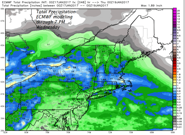
· Snowflakes in the air barely ever stop with flurry activity to contijue and persist as two weather system have baicalley merged for a longer fuse slow accumuation event into Thursday morning.

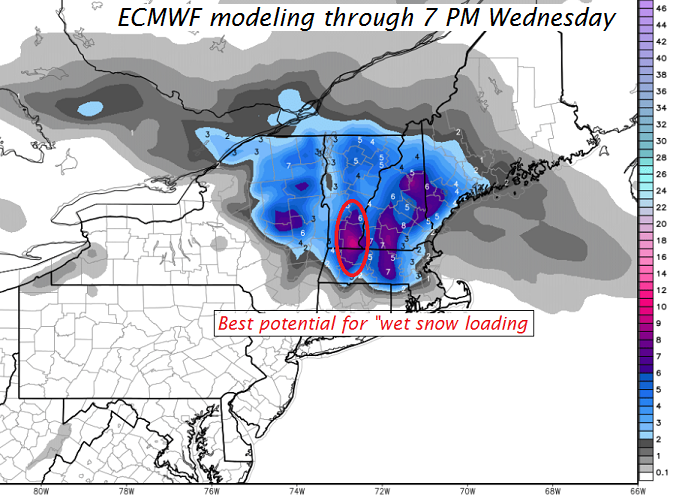
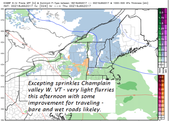
· Additional accumations of around inch or two mainly higher terrain but much lighter valley floors with some rain or sprinkles in the Champlain Valley

· After Thursday afternoon, we can finally end this current precipitation stringer and look forward to some decent sunshine on Friday – along with perhaps a “Sap Run” for any Sugarer’s that have their taps readied.

· Overall – not a bad weekend either. Next week I will be attending a conference and will be out of state.

· Next major storm system arrives Monday with yes more ugly wet snow/wintry mix potentially going over to all rain. Not a fan.

Winter Weather Advisory through this afternoon, all excepting the northern tier counties Central Champlain Valley…

TODAY: Mainly gray. Lingering snow showers this morning winding down as lighter flurries this afternoon. Additional accumulation of up to an inch or so especially higher terrain. A high about 32. South winds 10 to 15 mph.

TONIGHT: Occasional flurries or mountain snow showers. Accumulations of up to an inch higher terrain. A low in the upper 20s to near 30. South winds 10 to 15 mph.

THURSDAY: Chance for wet snow showers or flurries with minor accumulation. Intervals of afternoon sunshine. A high in the mid to upper 30s. Light south winds become westerly 10 to 15 mph.

Looking Further ahead…

THURSDAY NIGHT: Partly cloudy. A low 20 to 25.

FRIDAY: Pick of the week – A few morning clouds, otherwise lots of sunshine. A high near 40 – Maybe a sap run.

SATURDAY: More clouds than sun. Slight chance for a flurry or sprinkle. A low in the 20s. A high in the upper 30s. – Maybe a sap run.

SUNDAY: Partly to mostly sunny. A low 25 to 30. A high in the upper 30s to near 40.

MONDAY: Cloudy. Chance for a “wintry mix” of precipitation types making for hazardous travel. A low 25 to 30. Temperatures rising slowly through the low and mid 30s.

Average lows in the single digits. Normal highs in the 20s. Midpoint of meteorological winter – Jan. 232rd.

RH/1-18[end]

Updated Tuesday Evening Forecast — January 17th, 2017

Winter Weather Advisory in effect through 1 PM Wednesday excepting the northern tier counties…

TONIGHT: Wet snow developing by mid evening…moderate at times later on into the overnight. Accumulation of 3 to locally 6” with the most south. A low in the mid 20s. Southeast breeze 10 to 15 mph.

TOMORROW: Mainly gray. Lingering snow showers exiting as leftover flurries in the afternoon. A high about 32. South winds 10 to 15 mph.

WEDNESDAY NIGHT: Occasional flurries or mountain snow showers. Accumulations of up to an inch higher terrain. A low in the upper 20s. South winds 10 to 15 mph.

THURSDAY: Chance for wet snow showers or flurries. exiting to intervals of afternoon sunshine. A high upper 30s to near 40 – Maybe a sap run. Light south winds become westerly 10 to 15 mph.

Looking Further ahead…

THURSDAY NIGHT: Partly cloudy. A low 20 to 25.

FRIDAY: Pick of the week – A few morning clouds, otherwise lots of sunshine. A high 35 to 40 – Maybe a sap run.

SATURDAY: More clouds than sun. Slight chance for a few sprinkles late. A low 15 to 20. A high around 40 . – Maybe a sap run.

SUNDAY: Partly to mostly sunny. A low 20 to 25. A high in the mid 30s

Average lows in the single digits. Normal highs in the 20s.

RH/1-17[end]

Updated Tuesday morning Forecast & WX Notes — January 17th, 2017

· Pretty nice day today leading up to our next weather system for tonight . Tomorrow morning – “TRICKY TRAVEL” some of this wet snow especially south of the Barre-Montpelier area.

· Would be a good idea to leave early “slow down and drive conditions” with generally snow covered but likely tr5eated roads for the morning commute in Wednesday.

· Below is the ECMWF Model of which I depend on the most. Other modeling usually not always comes around the way of the European (ECMWF).

· What this shows is total melted precip water content forgetting what form it falls in below.

· Taking things into account are temperature levels and lifting dynamics of the storm which I is just too much to show. If these details are right and no curve balls the model usually captures not always and you come up with these snowfall amounts Below.

· Where the higher water content meets snow crystals as precipitation the expectation is that snow density will be highest and indeed it would appear that from the eastern slopes of Berkshires north into southern Green Mountains especially Windham and Windsor counties looks to problematic for utility outages.

TODAY: Filtered sunshine this morning, lowering and thickening clouds this afternoon. A high about 35 to 40. Southeasterly breeze 10 to 20 mph this afternoon.

Winter Weather Advisory in effect from 4 PM Tuesday through 1 PM Wednesday All but northern tier counties…

TONIGHT: Snow likely developing Tuesday evening moderate at times. Accumulation of 3 to locally 6” with the most toward southern Vermont. A low in the mid 20s. Southeast breeze 10 to 15 mph.

WEDNESDAY: Mainly gray. Lingering snow showers exiting as leftover flurries in the afternoon. A high 30 to 35. South winds 10 to 15 mph.

Looking Further ahead…

WEDNESDAY NIGHT: Occasional flurries or mountain snow showers. Accumulations of up to an inch higher terrain. A low 25 to 30.

THURSDAY: Considerable cloudiness with scattered morning flurries exiting to a few breaks of sun in the afternoon. A high upper 30s to near 40 – Maybe a sap run.

FRIDAY: Considerable high cloudiness, otherwise fair and dry. A low 25 to 30. A high near 40– Maybe a sap run.

SATURDAY: Cloudy. Slight chance for a few flurries or sprinkles. A low in the 20s. A high around 40 . – Maybe a sap run.

Average lows in the single digits. Normal highs in the 20s.

RH/1-17[end]