
· Pretty nice day today leading up to our next weather system for tonight . Tomorrow morning – “TRICKY TRAVEL” some of this wet snow especially south of the Barre-Montpelier area.
· Would be a good idea to leave early “slow down and drive conditions” with generally snow covered but likely tr5eated roads for the morning commute in Wednesday.
· Below is the ECMWF Model of which I depend on the most. Other modeling usually not always comes around the way of the European (ECMWF).
· What this shows is total melted precip water content forgetting what form it falls in below.
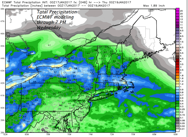
· Taking things into account are temperature levels and lifting dynamics of the storm which I is just too much to show. If these details are right and no curve balls the model usually captures not always and you come up with these snowfall amounts Below.
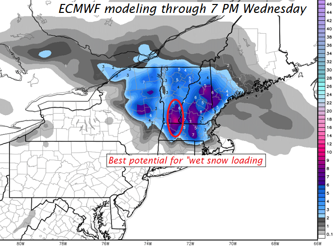
· Where the higher water content meets snow crystals as precipitation the expectation is that snow density will be highest and indeed it would appear that from the eastern slopes of Berkshires north into southern Green Mountains especially Windham and Windsor counties looks to problematic for utility outages.
TODAY: Filtered sunshine this morning, lowering and thickening clouds this afternoon. A high about 35 to 40. Southeasterly breeze 10 to 20 mph this afternoon.
Winter Weather Advisory in effect from 4 PM Tuesday through 1 PM Wednesday All but northern tier counties…
TONIGHT: Snow likely developing Tuesday evening moderate at times. Accumulation of 3 to locally 6” with the most toward southern Vermont. A low in the mid 20s. Southeast breeze 10 to 15 mph.
WEDNESDAY: Mainly gray. Lingering snow showers exiting as leftover flurries in the afternoon. A high 30 to 35. South winds 10 to 15 mph.
Looking Further ahead…
WEDNESDAY NIGHT: Occasional flurries or mountain snow showers. Accumulations of up to an inch higher terrain. A low 25 to 30.
THURSDAY: Considerable cloudiness with scattered morning flurries exiting to a few breaks of sun in the afternoon. A high upper 30s to near 40 – Maybe a sap run.
FRIDAY: Considerable high cloudiness, otherwise fair and dry. A low 25 to 30. A high near 40– Maybe a sap run.
SATURDAY: Cloudy. Slight chance for a few flurries or sprinkles. A low in the 20s. A high around 40 . – Maybe a sap run.
Average lows in the single digits. Normal highs in the 20s.
RH/1-17[end]
