
· Weak but nevertheless high pressure will make for periodic clouds mixed with sunshine with better afternoon coming on Friday also dry.
· Would not expect much, but the weakening band of precipitation from an older storm system will move through the Mid Atlantic rgion with showers or light rian Friday for The Presidential Inauguration Friday.
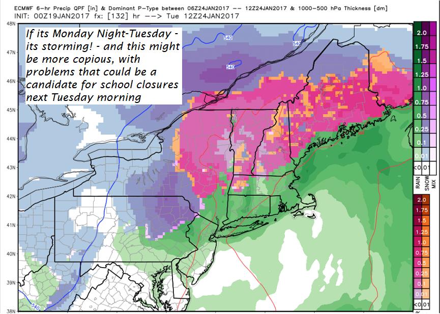
· Yikes – powerful thunderstorms with robust moisture will head toward Vermont affecting us early next week.
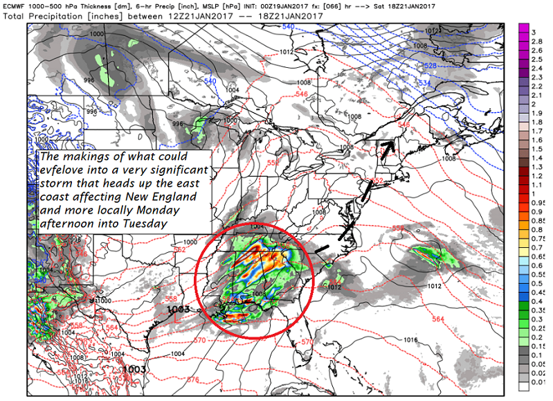
· Storm next week – Not looking good. Wintry mix is an uderstatement. However, over time history has been the “bark worse than the bite” as copious amounts of moisture advertised.
TODAY: Scattered light flurries near the Green Mountains and higher terrain early. Otherwise, lingering cloudiness with a possible break or hint of sunshine this afternoon. A high 35 to 40. Light winds become northwesterly 10 to 15 mph.
TONIGHT: Mostly cloudy. A low around 25. Little wind.
FRIDAY: Pick of the week – A few morning clouds, otherwise lots of sunshine. A high in the upper 30s to around 40 – Maybe a sap run. Light southeast winds.
Looking Further ahead…
FRIDAY NIGHT: Increasing clouds. A low in the mid 20s.
SATURDAY: More clouds than sun. Isolated sprinkles. A high in the upper 30s. – Maybe a sap run.
SUNDAY: Clouds mixed with sun. Slight chance for a flurry or valley sprinkle. A low around 30. A high around 35.
MONDAY: Cloudy. Good chance for a “wintry mix” of precipitation overspreading from south to north in the afternoon. Hazardous travel increasingly likely by late in the day. A low 25 to 30. A high around 32.
TUESDAY: Wintry mix of precipitation with poor travel conditions likely eventually changing to rain. A low around 25. A high in the mid 30s.
Average lows in the single digits. Normal highs in the 20s. Midpoint of meteorological winter – Jan. 23rd.
RH/1-19[end]
