Updated Wednesday Morning Forecast & WX Notes — February 8th, 2017

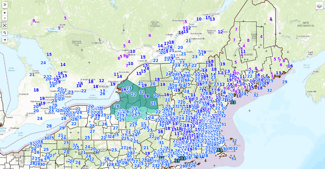
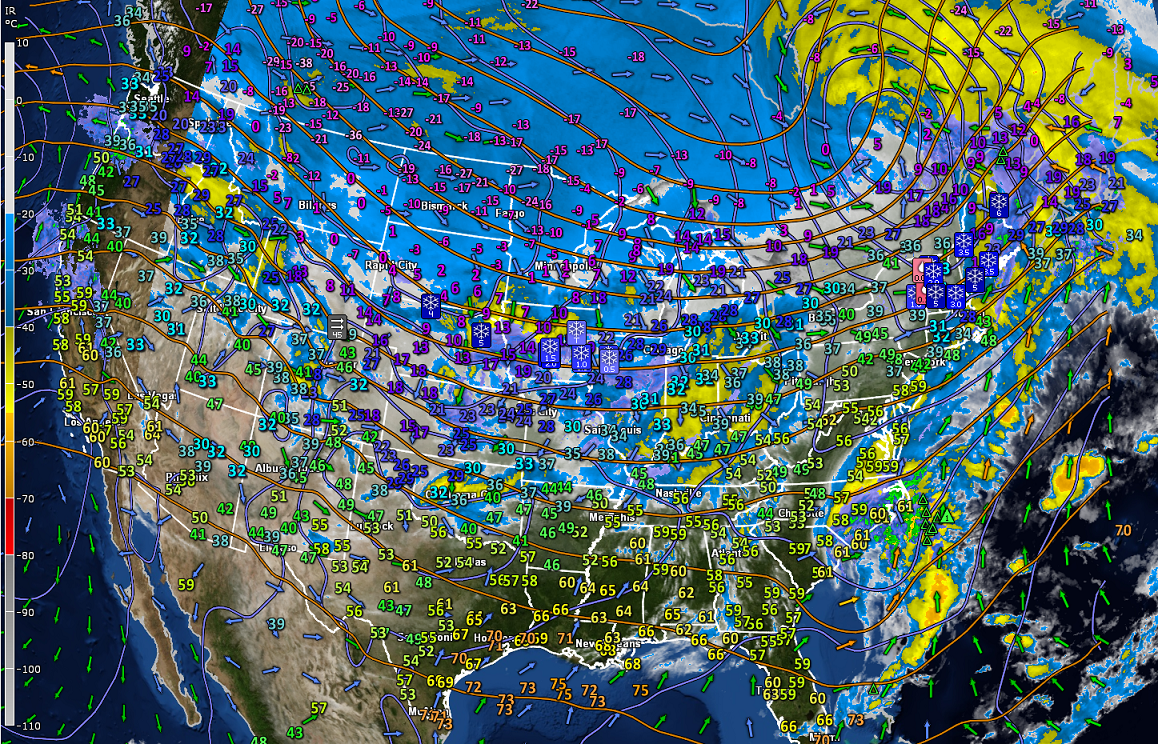
Super busy Weather Map

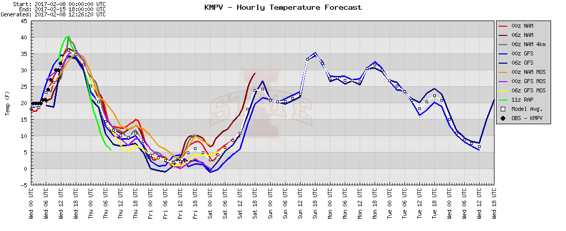
· Temperature Roller coasters continue in fact for some time to come…

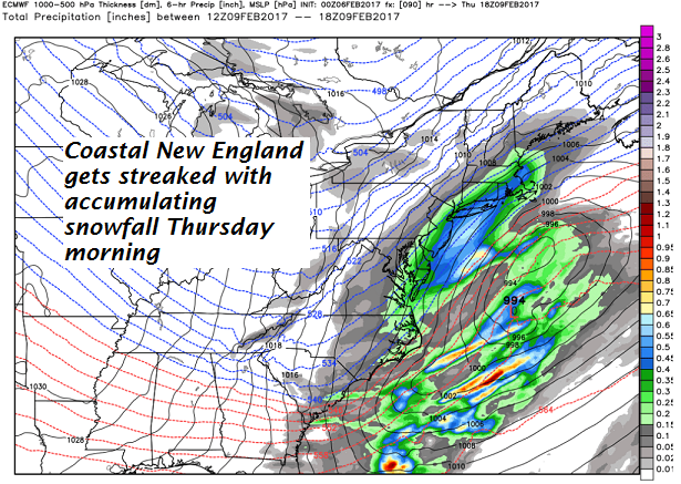
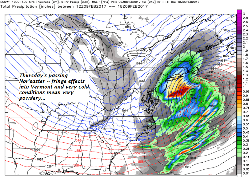
· Passing Nor’easter Thursday

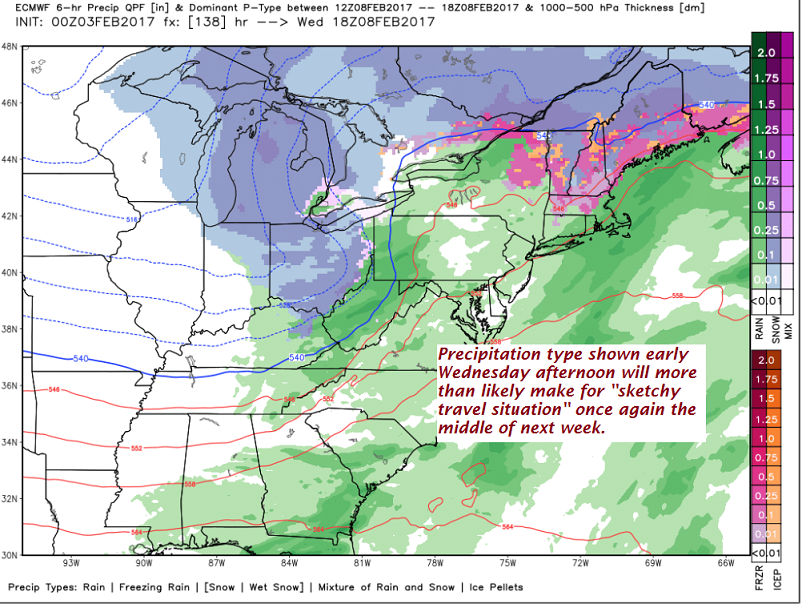
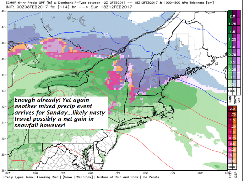
· Next mixed precipitation event arrives Sunday…

Winter Weather Advisory expires 10 AM this morning…

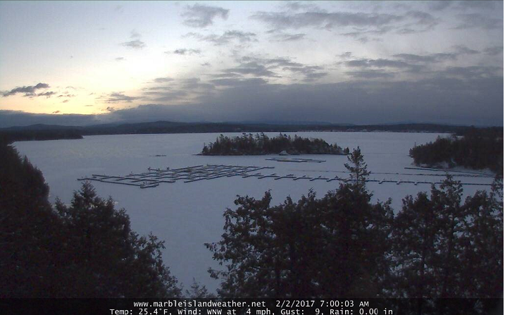
TODAY: Rain showers…tapering off mid morning with slick travel still likely in some spots east of the Green Mountains. Milder & blustery mid to late morning on with mixed clouds and sun and a chance for a sprinkle. A high in the upper 30s to low 40s. Westerly winds pick up 10 to 25 mph with higher gusts across the hills.

TONIGHT: Partly cloudy this evening clouding up overnight. Chance for light snow developing south of the Barre-Montpelier area. A low about 10 to 15. Northwest winds 10 to 15 mph.

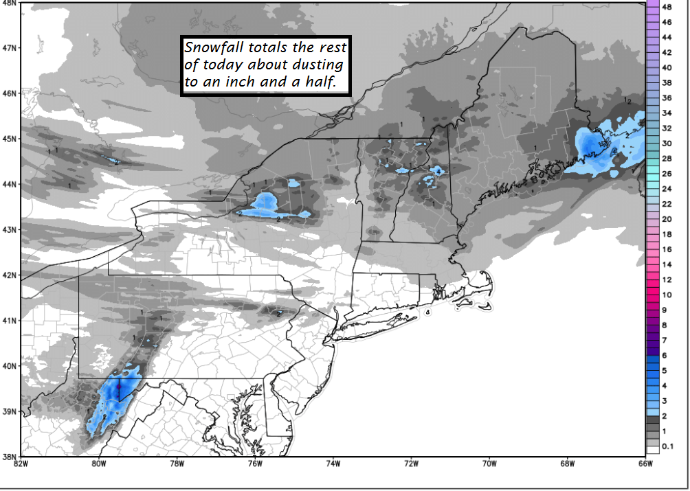
THURSDAY: Clouding up. Chance for light snow accumulation Barre-Montpelier area south. A dusting to an inch especially south Barre-Montpelier area with higher amounts SE VT. Temperatures holing in the teens. North winds 10 to 20 mph.

Looking Further ahead…

THURSDAY NIGHT: Clearing but cold! A low in the single digits below zero.

FRIDAY: Widely scattered flurries otherwise partly sunny. A high around 5 to 10 above.

SATURDAY: Clouds…with a good chance for light accumulating snow showers. A low 5 above to 5 below. below. A high in the teens.

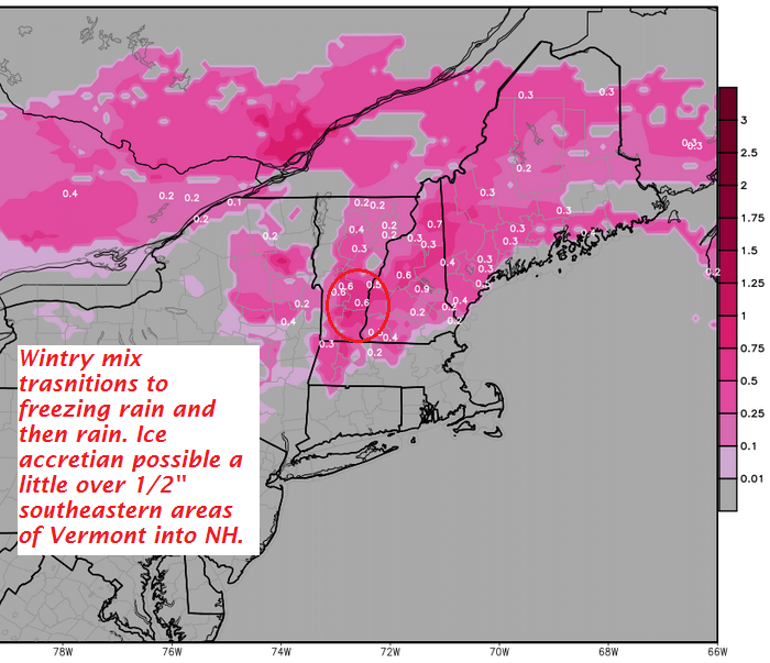
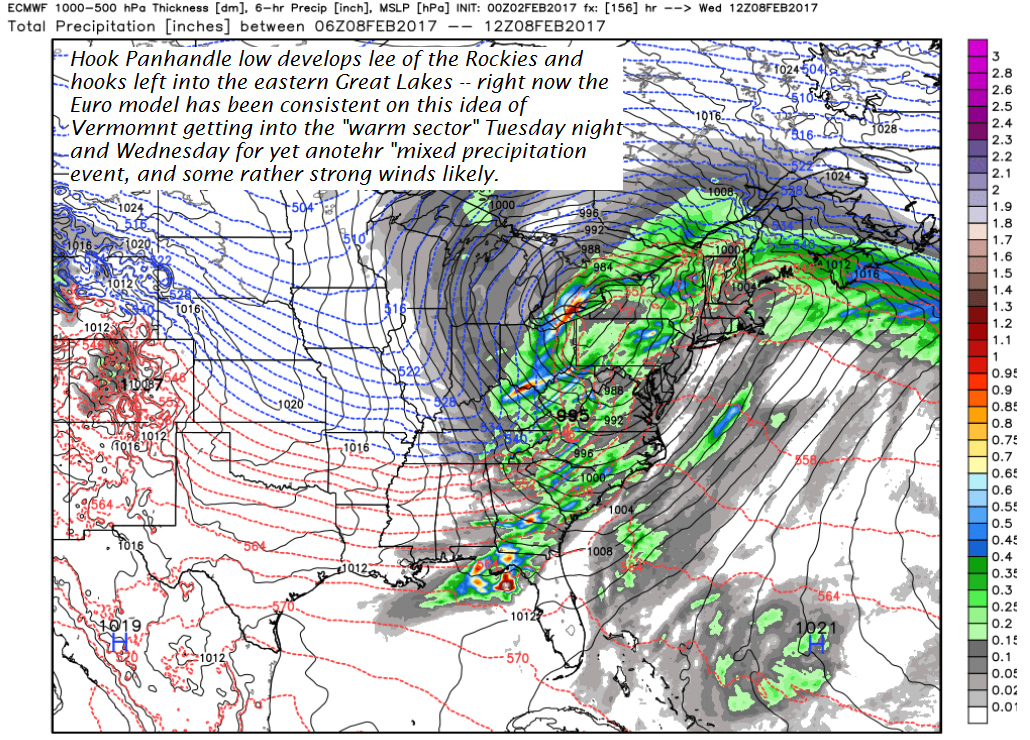
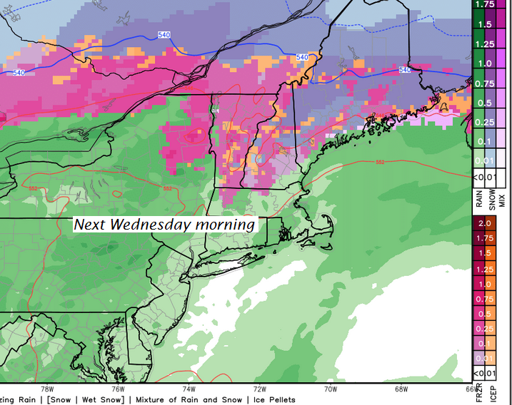
SUNDAY: Grey. A good chance for a wintry mix of precipitation types transitioning to all rain later in the afternoon. A low around 20 and high in the 30s.

MONDAY: Mainly cloudy. Scattered leftover snow or rain showers. A low in the 20s. A high in the 30s.

Average lows in the single digits. Normal highs in the upper 20s to low 30s.

RH/2-8[end]

Updated Tuesday Evening forecast — February 7th, 2017

Winter Weather Advisory through 7 AM Wednesday morning…

TONIGHT: Overcast. Snow…changing to sleet and freezing rain with treacherous travel and glazing likely. Ice accretion up to around one-quarter inch. Temperatures in the mid 20s rising to around 32 degrees by day break. Southeast winds 10 to 20 mph.

TOMORROW: Rain showers…tapering off mid morning. (Slick travel likely early) Milder & blustery with mixed clouds and sun and chance for a sprinkle. A high in the 40s. Westerly 10 to 25 mph with higher gusts across the hills.

WEDNESDAY NIGHT: Partly cloudy with scattered flurries. A low in the mid teens. Northwest winds 10 to 15 mph.

THURSDAY: Clouding up with light snow accumulation. A dusting to an inch Barre-Montpelier area north, and 1 to 3” south. Temperatures holing in the mid to upper teens. North winds 10 to 20 mph.

Looking Further ahead…

THURSDAY NIGHT: Evening clouds then clearing. A low in the single digits below zero.

FRIDAY: Slight chance for flurries otherwise partly sunny. A high around 5 to 10 above.

SATURDAY: Clouds…with a chance for snow showers. A low 5 to 15 below. A high in the teens.

SUNDAY: Chance for snow, mixing with sleet and freezing rain. A low in the teens and high in the 20s.

Average lows in the single digits. Normal highs in the upper 20s to low 30s.

RH/2-7[end]

Updated Monday evening forecast — February 6th, 2017

TONIGHT: Cloudy. Occasional accumulating snow showers or flurries. Around an inch or two of accumulation. A low in the mid to upper teens. Light winds.

Winter Weather Advisory Noon tomorrow thru 4 AM Wednesday morning…

TOMORROW: Cloudy and gray. Periods of light snow likely with 1 to locally 4” of accumulation. Snow mixing with sleet Rutland south later in the day. Temperatures in the mid 20s. Southeast winds increasing 10 to 15 mph.

TUESDAY NIGHT: Overcast. Sleet and wet snow transitions to periods of freezing rain and rain with treacherous travel and some glazing likely. Temperatures in the mid 20s rising toward the freezing mark by day break. Southeast winds 10 to 15 mph.

WEDNESDAY: Clouds with rain showers taper off toward late morning. Hazardous travel likely in the morning…sub-freezing ground temperatures. Milder in the afternoon & blustery with intervals of sunshine. A high in the 40s. Wind becoming westerly 10 to 25 mph with higher gusts.

Looking Further ahead…

WEDNESDAY NIGHT: Partly cloudy with scattered flurries. A low in the mid single digits to around the low teens.

THURSDAY: A few morning flurries, otherwise lots of high clouds. Turning colder, with a high in the mid teens to around 20.

FRIDAY: Chance for a morning flurry, then lots of sunshine but frigid. A low 5 below to 10 above. A high in the mid teens to near 20.

SATURDAY: Filtered sunshine. A low around zero. A high in the mid 20s.

Average lows in the single digits. Normal highs in the upper 20s to low 30s.

RH/2-6[end]

Updated Monday morning forecast & WX notes — February 6th, 2017

· More snow showers/flurries on the way late today (Monday) into the Tuesday with snow coated raods.

· Big transition storm works in late Tuesday southern Vermont and overspreads the region with snow to sleet to freezing rain to rain. Expecting about 1 to locally 4” amounts of snowfall before transition.

· Biggest glazing will east of the Green Mountains possibly as much as ½ inch ice accretian toward southern Vermont counties east of the Greens.

· A much quicker transition to rain showers western Vermont couties Tuesday night with less freezing rain likely as tempeatures quicklly push into the 40s by Wednesday morning.

·

· Rain showers tail off with blustery conditions on Wednesday but some intervals of sunshine likely as well.

·

· Expecting much colder quieter conditions late in the week. We might see yet another mixed precip and wind event late Sunday into Monday next week that looks relatively similar in fashion.

TODAY: Periods of morning sunshine then clouding up. A good chance for snow showers developing late. A high 20 to 25. Light winds.

TONIGHT: Mainly cloudy. Occasional accumulating snow showers or flurries. A dusting to an inch or so accumulation. A low in the mid to upper teens. Light southeast winds.

TUESDAY: Cloudy and gray. Periods of light snow likely with 1 to locally 4” of accumulation. Snow mixing with sleet Rutland south later in the day. Temperatures 20 to 25. Southeast winds increasing late in the day 10 to 15 mph.

Looking Further ahead…

TUESDAY NIGHT: Sleet and wet snow transitions to periods of freezing rain and rain with treacherous travel and some glazing likely. Temperatures rising through the 20s into the low 30s by day break.

WEDNESDAY: Clouds with rain showers taper off toward late morning Hazardous travel likely in the morning…sub-freezing ground temperatures. Milder in the afternoon but blustery with intervals of sunshine. A high in the 40s. Gusty west to southwest winds later in the afternoon.

THURSDAY: A few morning flurries, otherwise lots of high clouds. Much colder, with temperatures in the teens.

FRIDAY: Chance for a morning flurry, then lots of sunshine but frigid. A low around zero degrees. A high in the mid to upper teens.

Average lows in the single digits. Normal highs in the upper 20s to low 30s.

RH/2-6[end]

Updated Friday Evening Forecast — February 3rd, 2017

TONIGHT: Partly cloudy. Widely scattered flurries. A low 10 above to 5 below. West winds 10 mph.

TOMORROW: Partial morning sun then mostly cloudy with a stray mountain flurry. A high 20 to 25. West winds 10 to 25 mph.

SATURDAY NIGHT: Fair with high cloudiness. A low in the mid teens. Light southwest winds.

SUNDAY: More clouds than sunshine with occasional afternoon mountain snow showers & valley flurries. A dusting to couple inches possible. A high 25 to 30. Northwest winds 10 to 20 mph.

Looking Further ahead…

SUNDAY NIGHT: Occasional mountain snow showers and valley flurries. Minor accumulation. A low 15 to 20.

MONDAY: Chance of morning snow showers or flurries otherwise mixed clouds and sun. A high in the mid 20s.

TUESDAY: Morning sun then clouding up. A rising chance for light accumulating snow later in the afternoon. A low 10 to 15. A high in the 20s.

WEDNESDAY: Gray. Wintry mix likely giving way to light rain showers. Hazardous travel possible. A low in the 20s. A high in the mid 30s to around 40. Blustery with gusty west to southwest winds later in the afternoon.

THURSDAY: Mainly cloudy and grey. Blustery with occasional flurries and mountain snow showers. A low in the teens. A high in the 20s. Blustery west to southwest winds

Average lows in the mid to upper single digits. Normal highs in the mid 20s to around 30.

RH/2-3[end]

Updated Friday morning forecast & WX Notes — February 3rd, 2017

Above – Carry-over lake effect continues – this probably the new normal for many winters to come.

More ugliness in weather middle of next week –

TODAY: Partial morning sun then lots of afternoon clouds with scattered flurries and northern mountain snow showers. A dusting to an inch accumulation northern areas otherwise just a skiff of accumulation. A high 20 to 25. West winds 10 to 15 mph.

TONIGHT: Partly cloudy. Widely scattered flurries. A low 10 above to 5 below. West winds 10 mph.

SATURDAY: Partial morning sun then mostly cloudy with a stray mountain flurry. A high 20 to 25. West winds 10 to 25 mph.

Looking Further ahead…

SATURDAY NIGHT: Fair with high cloudiness. A low in the mid teens.

SUNDAY: Filtered sunshine through high clouds, except cloudy northern areas with occasional afternoon mountain snow showers & valley flurries. A high 25 to 30.

MONDAY: Chance of morning snow showers or flurries otherwise mixed clouds and sun.A low 15 to 20. A high in the mid 20s.

TUESDAY: Morning sun then clouding up. A rising chance for light accumulating snow or snow showers. A low 10 to 15. A high in the 20s.

WEDNESDAY: Gray. Wet snow likely…transitioning to light mixed precipitation with hazardous travel possible. A low in the 20s. A high in the mid 30s to around 40. Blustery with gusty west to southwest winds later in the afternoon.

THURSDAY: Mainly cloudy and Gray. A chance for wintry mix changing back to all snow with light to moderate accumulation. A low in the teens. A high in the 20s. Blustery west to southwest winds

Average lows in the mid to upper single digits. Normal highs in the mid 20s to around 30.

RH/2-3[end]

Updated Thursday Evening forecast — February 2nd, 2017

TONIGHT: Scattered clouds with a chance for flurries northern areas. A low 5 to 10. West winds 10 mph.

TOMORROW: Partial morning sun then lots of afternoon clouds with scattered flurries. A skiff of accumulation. A high 20 to 25. West winds 10 to 15 mph.

FRIDAY NIGHT: Partly cloudy. Widely scattered flurries. A low 5 above to 5 below. West winds 10 mph.

SATURDAY: Partial morning sun then mostly cloudy with a stray mountain flurry. A high in the mid teens to low 20s. West winds 10 to 25 mph.

Looking Further ahead…

SATURDAY NIGHT: Fair with high cloudiness. A low 10 to 15.

SUNDAY: Filtered sunshine through high clouds, except cloudy northern areas with occasional afternoon mountain snow showers & valley flurries. A high 25 to 30.

MONDAY: Chance of morning snow showers or flurries otherwise mixed clouds and sun.A low 15 to 20. A high in the 20s.

TUESDAY: Morning sun then clouding up. A rising chance for light snow or snow showers. A low in the single digits. A high in the 20s.

WEDNESDAY: Rain or mixed precipitation with hazardous travel possible. A low in the 20s. A high in the 40s.

Average lows in the mid to upper single digits. Normal highs in the mid 20s to around 30.

RH/2-2[end]

Updated Thursday morning forecast & WX Notes — February 2nd, 2017

· Couple different plumes of Lake moisture streaming far southern and far northern Vermont with good chunk of the state in-between – still expect an occasional passing flurry.

· Temperatures below this morning – not quite discernable is lake effect thermal gradient with effects down-wind of not only moisture but temperatures slihgly elevated warmer.

· Picturesque morning with snows capes into the Champlain Valley.

Now the ugly part —

· Yuck – too damn warm aloft!

TODAY: Mixed clouds and sunshine especially away for the Green Mountains. Chance for flurries especially far northern areas with minor accumulation. A high 25 to 30. West to northwest winds 10 to 20 mph.

TONIGHT: Partly cloudy. Scattered flurries. A low in the single digits. West winds 10 mph.

FRIDAY: Mostly cloudy. Flurries with just a skiff of accumulation. A high 20 to 25. West winds 10 to 15 mph.

Looking Further ahead…

FRIDAY NIGHT: Partly cloudy. Scattered flurries. A low 5 above to 5 below.

SATURDAY: Chance for a morning flurry, then partly to mostly sunny. A high in the mid teens to low 20s.

SUNDAY: Morning sun followed by increasing afternoon clouds with scattered snow showers or flurries. A low around 10. A high in the mid 20s.

MONDAY: Chance of morning snow showers or flurries otherwise more clouds than sun.A low in the mid teens. A high in the upper teens to low 20s.

TUESDAY: Clouding up with periods of light accumulating snow developing in the afternoon. A low in the single digits. A high in the 20s.

Average lows in the mid to upper single digits. Normal highs in the mid 20s to around 30.

RH/2-2[end]

Updated Wednesday Evening forecast — February 1st, 2017

TONIGHT: Partly cloudy with a few flurries early. Cloudy periods overnight with scattered snow showers or flurries with a dusting to an inch. A low 10 to 15. Light southwest winds.

TOMORROW: Partly to mostly cloudy with occasional flurries or mountain snow showers. A dusting to an inch. A high near 25. West to northwest winds 10 to 20 mph.

THURSDAY NIGHT: Partly cloudy. Scattered flurries. A low in the single digits. West winds 10 mph.

FRIDAY: Mostly cloudy. Flurries with just a skiff of accumulation. A high 20 to 25. West winds 10 to 15 mph.

Looking Further ahead…

FRIDAY NIGHT: Mostly cloudy. Scattered flurries. A low 5 above to 5 below.

SATURDAY: Chance for a morning flurry, then partly to mostly sunny. A high in the mid teens to low 20s.

SUNDAY: Morning sun followed by increasing afternoon clouds with scattered snow showers or flurries. A low around 10. A high in the mid 20s.

MONDAY: Chance of morning snow showers or flurries otherwise more clouds than sun.A low in the mid teens. A high in the upper teens to low 20s.

TUESDAY: Mostly cloudy with periods of light snow accumulating snow showers. A low in the sing digits. A high in the 20s.

Average lows in the mid to upper single digits. Normal highs in the mid 20s to around 30.

RH/2-1[end]

Updated Wednesday morning forecast & WX notes — February 1st, 2017

· Carry-over lake effect will be in style and where the more persistent bands set up like mother nature’s snow gun.

· Meteorological Output Stat’s or (MOS) from the mighty Euro model.

TODAY: Intermittent light accumulating snow through mid day, tapering off to scattered snow showers and valley flurries. Totally accumulation 1 to 2 inches. Breaks of late afternoon sunshine with a high in the low 30s. West breeze 10 mph.

TONIGHT: Scattered clouds in the evening with a few stray flurries. Cloudy periods overnight with scattered snow showers or flurries with a dusting to an inch. A low in the teens. Light southwest winds.

THURSDAY: Partly to mostly cloudy with occasional flurries or mountains snow showers. A dusting to an inch. A high 20 to 25. West to northwest winds 10 to 20 mph.

Looking Further ahead…

THURSDAY NIGHT: Partly cloudy. Scattered flurries. A low 5 above to 5 below.

FRIDAY: Mostly cloudy. Maybe a late day flurry. A high 20 to 25.

SATURDAY: Chance for a morning flurry, then partly to mostly sunny. A low 5 above to 5 below. A high in the low to mid teens.

SUNDAY: Morning sun followed by increasing afternoon clouds leading to a chance for late day snow showers. Frigid morning with a low 5 below to 5 above. A high 25 to 30.

MONDAY: Chance of snow showers or flurries otherwise more clouds than sun.A low in the mid teens. A high in the low to mid 20s.

Average lows in the mid to upper single digits. Normal highs in the mid 20s to around 30.

RH/2-1[end]