
· More snow showers/flurries on the way late today (Monday) into the Tuesday with snow coated raods.
· Big transition storm works in late Tuesday southern Vermont and overspreads the region with snow to sleet to freezing rain to rain. Expecting about 1 to locally 4” amounts of snowfall before transition.
· Biggest glazing will east of the Green Mountains possibly as much as ½ inch ice accretian toward southern Vermont counties east of the Greens. 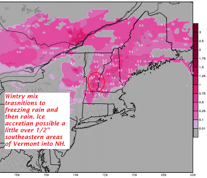
· A much quicker transition to rain showers western Vermont couties Tuesday night with less freezing rain likely as tempeatures quicklly push into the 40s by Wednesday morning.
· 
· Rain showers tail off with blustery conditions on Wednesday but some intervals of sunshine likely as well.
· 
· Expecting much colder quieter conditions late in the week. We might see yet another mixed precip and wind event late Sunday into Monday next week that looks relatively similar in fashion.
TODAY: Periods of morning sunshine then clouding up. A good chance for snow showers developing late. A high 20 to 25. Light winds.
TONIGHT: Mainly cloudy. Occasional accumulating snow showers or flurries. A dusting to an inch or so accumulation. A low in the mid to upper teens. Light southeast winds.
TUESDAY: Cloudy and gray. Periods of light snow likely with 1 to locally 4” of accumulation. Snow mixing with sleet Rutland south later in the day. Temperatures 20 to 25. Southeast winds increasing late in the day 10 to 15 mph.
Looking Further ahead…
TUESDAY NIGHT: Sleet and wet snow transitions to periods of freezing rain and rain with treacherous travel and some glazing likely. Temperatures rising through the 20s into the low 30s by day break.
WEDNESDAY: Clouds with rain showers taper off toward late morning Hazardous travel likely in the morning…sub-freezing ground temperatures. Milder in the afternoon but blustery with intervals of sunshine. A high in the 40s. Gusty west to southwest winds later in the afternoon.
THURSDAY: A few morning flurries, otherwise lots of high clouds. Much colder, with temperatures in the teens.
FRIDAY: Chance for a morning flurry, then lots of sunshine but frigid. A low around zero degrees. A high in the mid to upper teens.
Average lows in the single digits. Normal highs in the upper 20s to low 30s.
RH/2-6[end]
