Updated Tuesday morning Forecast & WX Notes — February 14th, 2017 Valentine’s day

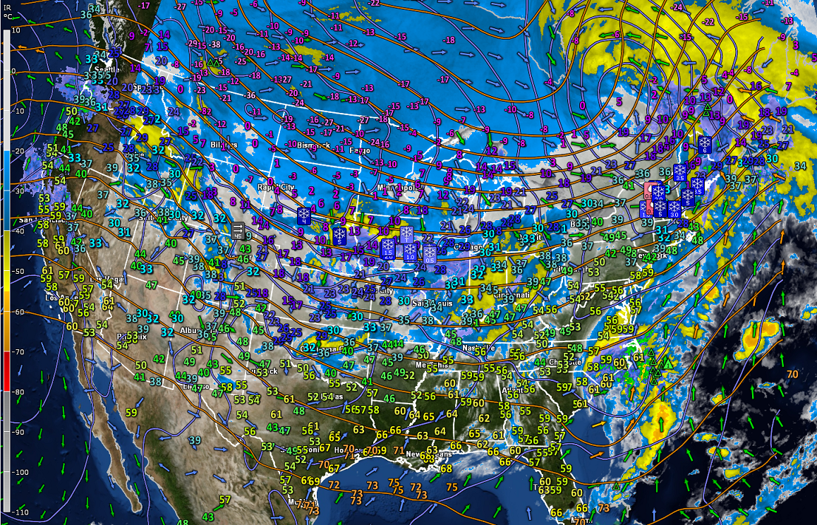
· Decent day today but always never-ending flurry activity (Lake Effect Climate change – Surface lake temps warm enough to emit moisture well into late winter these days…)

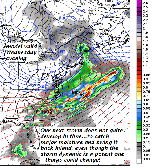
· Below…next weather system nosing in with light flurry, snow shower activity around midnight and after with “snow coated roads likely” Wednesday morning commute.

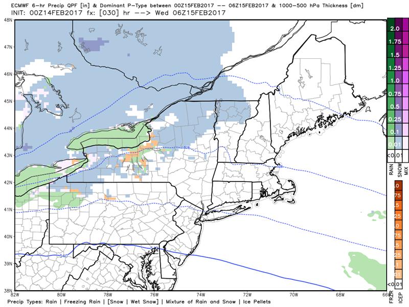
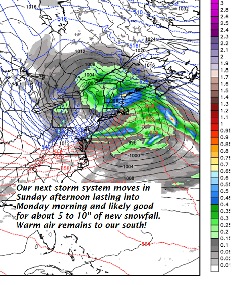
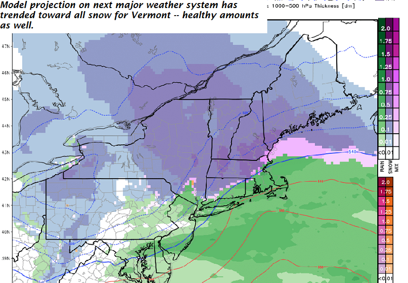
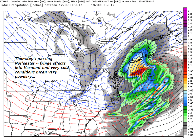
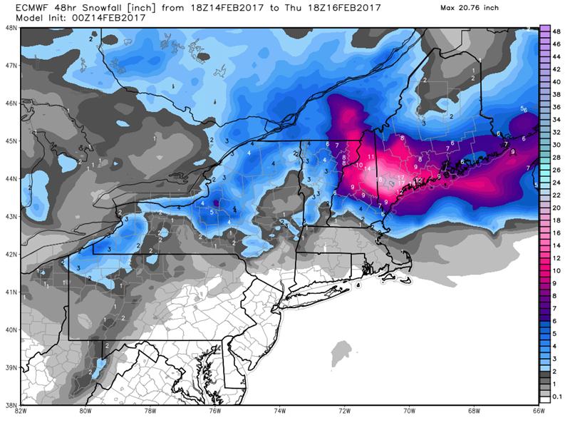
· Below evolution of storm system winds up and Atlantic moisture conveyor tracks back into interior New England with a moisture tongue into Vermont’s Northeast Kingdom…and lesser moisture otherwise rest of Vermont.

Net result is moderate snowfall Essex, Orleans and Caledonia counties…

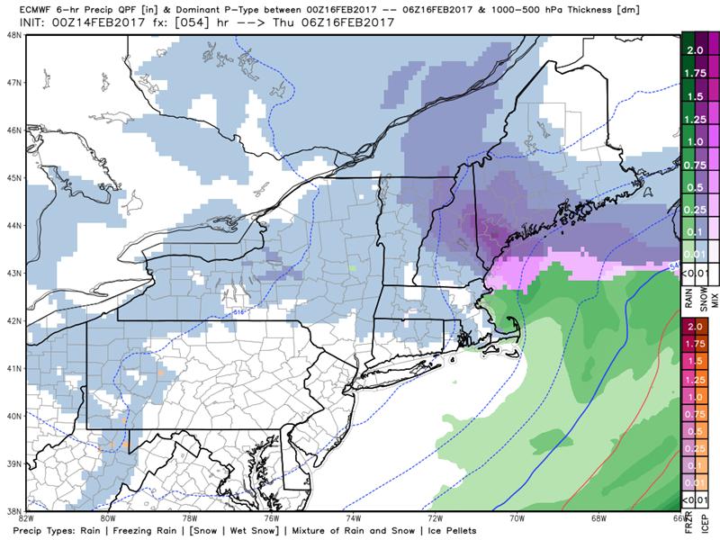
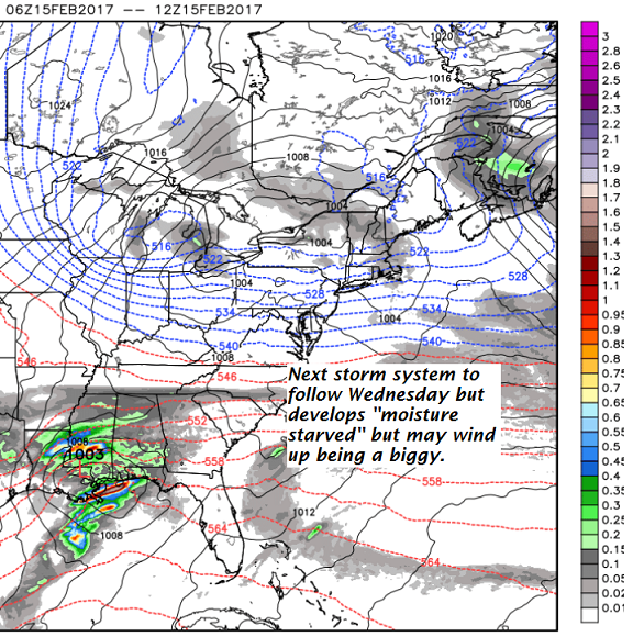
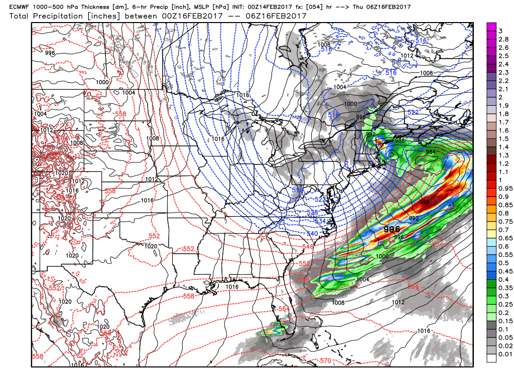
· Net results as advertised by European modeling..

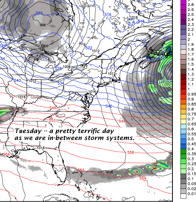
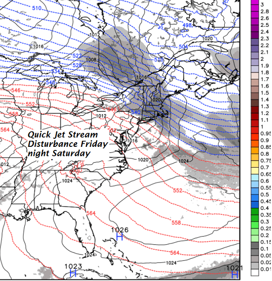
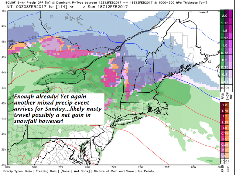
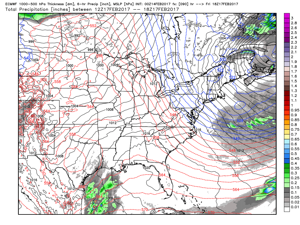
· Below Higher pressure builds to our west but blustery conditions Friday still qualifies as the pick of the week (DRY!)

And for the weekend —

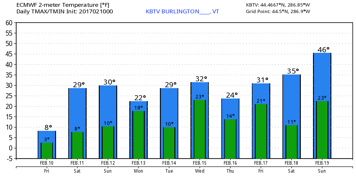
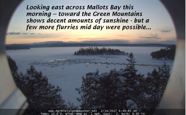
TODAY: Partly sunny. Chance for a mid day flurry or two. A high in the upper 20s. Light winds.

Winter Storm Watch Caledonia, Essex and Orleans Counties – late overnight through Thursday Morning…

TONIGHT: Mainly cloudy. Snow showers likely developing after midnight with accumulation of an inch or less. A low around 20. Southeast winds 10 mph.

WEDNESDAY: Mainly cloudy. Periods of accumulating snow or snow showers. with 1 to locally 4 ” accumulation with the most Northeast Kingdom. A high near 32. Southeast winds 10 to 15 mph.

Looking Further ahead…

WEDNESDAY NIGHT: Periods of snow. Total accumulation 3 to 9” with the most toward Essex County. A low in the low 20s.

THURSDAY: Scattered leftover light snow showers or flurries winding down in the afternoon. A high around 25.

FRIDAY: Pick of the week – Morning clouds then mostly sunny. A low around 15. A high in the mid 20s.

SATURDAY: Fair and a little milder with variable high clouds. A low in the single digits. A high around 35.

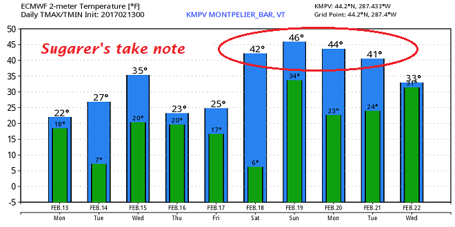
SUNDAY: Lots of sunshine and milder. Possible sap run. A low in the 20s. A high in the 40s.

Average lows in the mid single digits to low teens. Normal highs in the upper 20s to low 30s.

RH/2-14[end]

Updat4ed Monday Evening forecast — February 13th, 2017

TONIGHT: Partly to mostly cloudy, slight chance for a stray flurry. A low 5 to 10 above. Northwest winds 10 to 15 mph.

TOMORROW: Pretty nice day! Filtered sunshine through high clouds. A high in the mid 20s. Light winds.

TUESDAY NIGHT: Mainly cloudy. A rising chance for light snow showers after midnight. A dusting to an inch. A low around 20. Southeast winds 10 mph.

WEDNESDAY: Mainly cloudy. Periods of accumulating snow or snow showers with 2 to about 4” accumulation mostly across Northeast Kingdom. A high around 32. Southeast winds 10 to 15 mph.

Looking Further ahead…

WEDNESDAY NIGHT: Periods of light snow with additional accumulation of 1 to 3” mostly toward Northeast Kingdom. A low in the low 20s.

THURSDAY: Mostly cloudy with scattered mountain snow showers and valley flurries tapering off in the afternoon. A high in the mid 20s.

FRIDAY: Pick of the week – Morning clouds then mostly sunny. A low around 15. A high in the mid 20s.

SATURDAY: Fair and a little milder with variable high clouds. A low in the single digits. A high around 35.

SUNDAY: Lots of sunshine and milder. Possible sap run. A low in the 20s. A hug in the 40s.

Average lows in the mid single digits to low teens. Normal highs in the upper 20s to low 30s.

RH/2-13[end]

Updated Monday Morning Forecast & WX Notes — February 13th, 2017

· As current storm system winds down in snowfall…winds will flare up out of the northwest and produce localized white-outs, unloading trees and with considerable blowing and drifting.

· The winds were most aloft but will mix downward onto valley floors and kick up at times ferociously across central and southern Vermont

Next weather maker – not a big snow producer, but still a 1 to locally 3” amounts of additional snowfall – however things could evolve better if moisture stream stronger.

Temperature forecast going into the middle part of next week – Sugarer’s take note.

Winter storm Warning expires early this evening…

TODAY: Occasional snow showers and flurries gradually winding down this morning. Additional accumulation dusting to 2“. A few breaks of sun possible away for the mountains with a leftover stray flurry or two. Blustery northwest winds with blowing and drifting snow causing white-outs in exposed areas. Total storm accumulation 7 to 13”. A high in the low to mid 20s. Northwest winds picking up this morning at 10 to 25 mph with higher gusts across hills.

TONIGHT: Partly to mostly cloudy, slight chance for a stray flurry. A low 5 to 10 above. Northwest winds 10 to 15 mph.

TUESDAY: Pretty nice day! Filtered sunshine through high clouds. A high in the mid 20s. Light winds.

Looking Further ahead…

TUESDAY NIGHT: A rising chance for light snow showers after midnight. Minor accumulation. A low around 20.

WEDNESDAY: Frequent mountain snow showers and flurries. A high reaching into the low to mid 30s.

THURSDAY: Mostly cloudy with scattered mountains snow showers and valley flurries. A low upper teens to low 20s. A high in the mid to upper 20s.

FRIDAY: Pick of the week – Morning clouds giving way to lots of afternoon sunshine. A low in the teens. A high in the mid 20s.

SATURDAY: A few morning clouds…otherwise mostly sunny, gorgeous and much milder. A sap run possible for Sugarer’s with a high in the upper 30s to mid 40s.

Average lows in the mid single digits to low teens. Normal highs in the upper 20s to low 30s.

RH/2-13[end]

Updated Friday Evening Forecast — February 10th, 2017

TONIGHT: Mostly clear skies into mid evening then increasing clouds. Light snow developing toward midnight. Accumulation of 1 to 2 inches. A low in the single digits. Light southeast winds.

TOMORROW: Light accumulating snow or snow showers tapering off in the afternoon. Some minor additional accumulation. A high in the 20s. Southeast winds 10 to 15 mph.

SATURDAY NIGHT: Variable clouds.A low 5 to 15 above. Light southeast winds.

SUNDAY: Gray. Snow developing in the afternoon with about 2 to 4” accumulation. A high 25 to 30. Southeast winds 10 to 20 mph

Looking Further ahead…

SUNDAY NIGHT: Snow…moderate at times. Accumulation of a few to several inches. A low 15 to 20.

MONDAY: Snow…moderate at times in the morning . Total storm accumulation 6 to 12”. A high in the low to mid 20s.

TUESDAY: Mostly cloudy with scattered leftover flurries. A low in the single digits. A high in the 20s.

WEDNESDAY: Variable clouds. Chance for a mountain flurry. A low 15 to 20. A high around 32.

Average lows in the single digits. Normal highs in the upper 20s to low 30s.

RH/2-10[end]

Updated Friday morning Forecast (TGIF) & WX Notes — February 10th, 2017

· Fairly brutal wind chills across some parts of the region along with some minor drifting and blowing of the newly fallen snow. Watch it this morning as always with snow coated roadways…

· Below are the latest temperatures projects by the Euro model ahead centered on Burlington VT.

· Many storms in the pipe…most minor but all snow…

· Combination of two different branches of the jet stream combine with energy phasing together for a “Miller B” Nor’easter (late bloomer developing in Gulf of Maine)

· More jet energy middle of next week from a “Clipper System” evolves quicker but moisture starved.

· No one storm as big as what New York City to Boston just saw, but a few minor ones and a moderately big one could do the trick…

Wind Chill Advisory expires at 10 AM…

TODAY: Occasional flurries this morning with minor accumulation and cold wind chills. Otherwise intervals of sun and frigid with a stray mountain flurry drying up this afternoon. A high 5 to 10 above. Northwest winds 10 to 20 mph lowering wind chills in the minus 20s

TONIGHT: Cloudy. Light snow developing overnight. Accumulation of 1 to 2 inches. A low in the single digits. Light southeast winds.

SATURDAY: Light accumulating snow or snow showers tapering off in the afternoon. Some minor additional accumulation. A high 20 to 25. Southeast winds 10 to 15 mph.

Looking Further ahead…

SATURDAY NIGHT: Variable clouds.A low around 10.

SUNDAY: Gray. Snow developing in the afternoon with about 2 to 4” accumulation. A high in the mid 20s to near 30.

MONDAY: Mainly cloudy. Occasional light snow tapering off late. Total storm accumulation 5 to 10”. A low in the upper teens. A high in the 20s.

TUESDAY: Cloudy. Chance for light snow showers or flurries. Additional minor accumulation. A low in the single digits. A high in the 20s.

WEDNESDAY: Variable clouds. Chance for a mountain flurry. A low 15 to 20. A high around 32.

Average lows in the single digits. Normal highs in the upper 20s to low 30s.

RH/2-10[end]

Updated Thursday Evening forecast — February 9th, 2017

TONIGHT: Clearing but cold! A low in the single digits below zero. Northwest winds 10 mph with lowered wind chills.

TOMORROW: A stray flurry or two Northeast Kingdom, otherwise intervals of sun and frigid!A high around 5 to 10 above. Northwest winds 10 to 20 mph lowering wind chills

FRIDAY NIGHT: Cloudy. Chance for light snow showers up to an inch of fluffy accumulation. A low 5 below to 5 above. Light southeast winds.

SATURDAY: Clouds…with a good chance for light accumulating snow showers. A dusting to an inch or so. A high 15 to 20. Southeast winds 10 to 15 mph.

Looking Further ahead…

SATURDAY NIGHT: Variable clouds.A low around 10.

SUNDAY: Gray. A good chance for snow with potential for a few to several inches of accumulation. A risk for mixed precipitation making for hazardous travel. A high in the mid 20s to near 30.

MONDAY: Mainly cloudy. Scattered leftover snow showers. A low in the upper teens. A high in the 20s.

TUESDAY: Partly to mostly sunny. A low in the single digits. A high in the mid 20s.

WEDNESDAY: Filtered sunshine through high clouds. A low around 20. A high around 30.

Average lows in the single digits. Normal highs in the upper 20s to low 30s.

RH/2-9[end]

Updated Wednesday morning forecast & WX notes — February 9th, 2017

· Depicted precipitation working through southern New England…

· After a weak disturbance good for a dusting to 2” Friday night into the Saturday evening – our next bigger system arrives Sunday into Monday.

· Model trends have been colder keeping this system snow rather than a mix advertised less the 24 hours ago.

TODAY: Gray with occasional light snow, tapering off mid to late afternoon. An inch to 3” inches with higher amounts southern and eastern areas. Temperatures holding in the teens. North to northwest winds 10 to occasionally 20 mph.

TONIGHT: Clearing but cold! A low in the single digits below zero. Northwest winds 10 mph with lowered wind chills.

FRIDAY: Widely scattered flurries otherwise intervals of sunshine and frigid!A high around 5 to 10 above. Northwest winds 10 to 20 mph lowering wind chills

Looking Further ahead…

FRIDAY NIGHT: Cloudy. Chance for light snow showers up to an inch of fluffy accumulation. A low in the single digits above zero

SATURDAY: Clouds…with a good chance for light accumulating snow showers. A high in the teens.

SUNDAY: Gray. A good chance for snow with potential for few to several inches of accumulation. A risk for mixed precipitation making for hazardous travel. A low 10 to 15. A high in the mid 20s to near 30.

MONDAY: Mainly cloudy. Scattered leftover snow showers. A low in the teens. A high in the 20s.

TUESDAY: Partly to mostly sunny. A low in the single digits. A high 25 to 30.

WEDNESDAY: Filtered sunshine through high clouds. A low 15 to 20. A high around 30.

Average lows in the single digits. Normal highs in the upper 20s to low 30s.

RH/2-9[end]

Updated Wednesday Evening Forecast — February 17th, 2017

TONIGHT: Scattered clouds this evening, clouding up overnight. Chance for light snow developing around daybreak. A low about 10 to 15. Northwest winds 10 mph.

TOMORROW: Gray with occasional light snow tapering off in the afternoon. A dusting to an inch with higher amounts southern and eastern areas. Temperatures holing in the teens. North to northwest winds 10 to 20 mph.

THURSDAY NIGHT: Clearing but cold! A low in the single digits below zero. Northwest winds 10 mph with lowered wind chills.

FRIDAY: Widely scattered flurries otherwise partly sunny. A high around 5 to 10 above. Northwest winds 10 to 20 mph lowering wind chills

Looking Further ahead…

FRIDAY NIGHT: Cloudy. Chance for light snow showers up to an inch of fluffy accumulation. A low in the single digits above zero

SATURDAY: Clouds…with a good chance for light accumulating snow showers. A high in the teens.

SUNDAY: Gray. A good chance for accumulating snow or wet snow or a wintry mix with hazardous travel possible. A low in the teens. A high near 32.

MONDAY: Mainly cloudy. Scattered leftover snow or rain showers. A low in the 20s. A high in the 30s.

TUESDAY: Partly to mostly sunny. A low around 15. A high 35 to 40.

Average lows in the single digits. Normal highs in the upper 20s to low 30s.

RH/2-8[end]

Roger Hill

Weathering Heights Consulting

186 MacKenzie Dr.

Worcester VT 05682

icon-envelope-tick-round-orange-animated-no-repeat-v1.gif Virus-free. www.avast.com

Updated Wednesday Morning Forecast & WX Notes — February 8th, 2017

Super busy Weather Map

· Temperature Roller coasters continue in fact for some time to come…

· Passing Nor’easter Thursday

· Next mixed precipitation event arrives Sunday…

Winter Weather Advisory expires 10 AM this morning…

TODAY: Rain showers…tapering off mid morning with slick travel still likely in some spots east of the Green Mountains. Milder & blustery mid to late morning on with mixed clouds and sun and a chance for a sprinkle. A high in the upper 30s to low 40s. Westerly winds pick up 10 to 25 mph with higher gusts across the hills.

TONIGHT: Partly cloudy this evening clouding up overnight. Chance for light snow developing south of the Barre-Montpelier area. A low about 10 to 15. Northwest winds 10 to 15 mph.

THURSDAY: Clouding up. Chance for light snow accumulation Barre-Montpelier area south. A dusting to an inch especially south Barre-Montpelier area with higher amounts SE VT. Temperatures holing in the teens. North winds 10 to 20 mph.

Looking Further ahead…

THURSDAY NIGHT: Clearing but cold! A low in the single digits below zero.

FRIDAY: Widely scattered flurries otherwise partly sunny. A high around 5 to 10 above.

SATURDAY: Clouds…with a good chance for light accumulating snow showers. A low 5 above to 5 below. below. A high in the teens.

SUNDAY: Grey. A good chance for a wintry mix of precipitation types transitioning to all rain later in the afternoon. A low around 20 and high in the 30s.

MONDAY: Mainly cloudy. Scattered leftover snow or rain showers. A low in the 20s. A high in the 30s.

Average lows in the single digits. Normal highs in the upper 20s to low 30s.

RH/2-8[end]

Updated Tuesday Evening forecast — February 7th, 2017

Winter Weather Advisory through 7 AM Wednesday morning…

TONIGHT: Overcast. Snow…changing to sleet and freezing rain with treacherous travel and glazing likely. Ice accretion up to around one-quarter inch. Temperatures in the mid 20s rising to around 32 degrees by day break. Southeast winds 10 to 20 mph.

TOMORROW: Rain showers…tapering off mid morning. (Slick travel likely early) Milder & blustery with mixed clouds and sun and chance for a sprinkle. A high in the 40s. Westerly 10 to 25 mph with higher gusts across the hills.

WEDNESDAY NIGHT: Partly cloudy with scattered flurries. A low in the mid teens. Northwest winds 10 to 15 mph.

THURSDAY: Clouding up with light snow accumulation. A dusting to an inch Barre-Montpelier area north, and 1 to 3” south. Temperatures holing in the mid to upper teens. North winds 10 to 20 mph.

Looking Further ahead…

THURSDAY NIGHT: Evening clouds then clearing. A low in the single digits below zero.

FRIDAY: Slight chance for flurries otherwise partly sunny. A high around 5 to 10 above.

SATURDAY: Clouds…with a chance for snow showers. A low 5 to 15 below. A high in the teens.

SUNDAY: Chance for snow, mixing with sleet and freezing rain. A low in the teens and high in the 20s.

Average lows in the single digits. Normal highs in the upper 20s to low 30s.

RH/2-7[end]