TONIGHT: Scattered evening flurries…drying up before midnight, otherwise gradual clearing skies. A low around 20. Light northwest winds.
TOMORROW: Pick of the week. Sunshine, giving way to more clouds late. A high mid to upper 30s. Light northwest winds.
THURSDAY NIGHT: Increasingly cloudy. A period of light freezing rain around midnight changing to rain before exiting. Caution slick spots likely. An evening low near 25, as temperatures rise into the mid 30s toward daybreak. Light southeast winds.
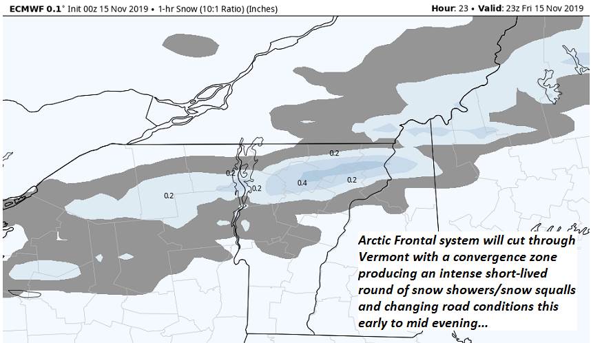
FRIDAY: Mainly cloudy, milder and blustery to windy. Rain showers redeveloping mixing or changing to wet snow showers late. A high near 45. South winds shifting to westerly 10 to 25 mph and gusty.
Looking further ahead…
FRIDAY NIGHT: A few leftover flurries early, then clearing skies. A low in the upper teens.
SATURDAY: Mostly sunny with high clouds late. A high 32 to 35.
SUNDAY: Chance for light accumulating snow central and southern Vermont, otherwise cloudy. A low mid to upper teens. A high in the mid 30s.
MONDAY: Mixed clouds and sun. A low 20 to 25. A high in the mid 30s.
Average lows mid to upper 20s. Average highs 40 to 45.
RH/11-20-19[end]