
TODAY: Partial morning sun, then clouding up. A rising chance for mainly afternoon flurries toward the Quebec border. A high about 35. Southwest breeze 10 to 20 mph.
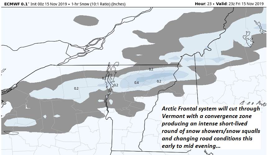
TONIGHT: Overcast. Occasional snow showers & snow squalls early to mid evening. A quick dusting to an inch. Sharply colder overnight. Near record cold lows…zero to 5 above. Winds becoming northwesterly and gusty through the evening 10 to 20 mph lowering wind chills.
SATURDAY: Sunny but cold. A high ranging in the 20s. Light north to northwest winds.
Looking further ahead…
SATURDAY NIGHT: Clear and partially moonlit. Frigid. Near record cold lows ranging 5 below to 5above.
SUNDAY: Partly to mostly sunny after frigid start. A high in the low 30s.
MONDAY: Cloudy. A rising chance for a messy mix of precipitation…with slick travel developing later in the afternoon. A low in the teens. A high mid 30s.
TUESDAY: Considerable cloudiness. Chance for light accumulating wet snow in the morning tapering to scattered sprinkles. A low near 30 degrees. A high in the mid to upper 30s
WEDNESDAY: Clouds mixed with breaks of sun. Scattered mountain flurries. A low in the mid to upper 20s. A high around 35.
Average lows mid 20s to upper 20s. Average highs in the low to mid 40s.
RH/11-15-19[end]
