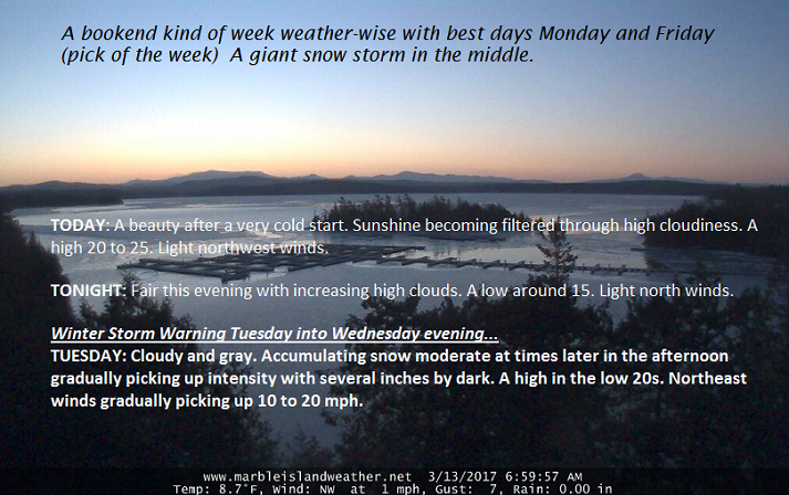
updated Tuesday night Forecast

March 14th

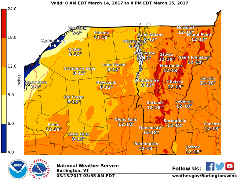
Winter Storm Warning through 8 PM Wednesday evening…

TONIGHT: Snow – moderate to heavy at times with accumulation rates ½ inch to an inch per hour this evening…winding down overnight. Additional snow 5 to locally 10” Temperatures in the low to mid teens. Blowing and drifting snow with white-out conditions producing treacherous travel. Northwest winds 10 to 25 mph and gusty.

TOMORROW: Occasional light accumulating snow with about ½ inch to 2”. Total snow accumulation 14 to 22” Temperatures in the upper teens to mid 20s. Gusty northwest winds with occasional blowing and drifting and white-outs at 10 to 20 mph.

WEDNESDAY NIGHT: Occasional light snow showers or flurries. A dusting to an inch. Colder. A low in the single digits. Northwest winds 10 to 15 mph.

THURSDAY: Mostly cloudy. Scattered flurries winding down. A high in the upper teens to low 20s.Gusty northwest winds 10 to 20 mph.

Looking Further ahead…

THURSDAY NIGHT: Becoming mostly clear and colder. A low 5 to 10.

FRIDAY: Pick of the week – a beauty with blue skies and bright sunshine. A high 25 to 30.

SATURDAY: Sunshine giving way to thickening clouds. A low in the single digits. A high near 32.

SUNDAY: Partly sunny. A low in the single digits with a high in the 30s.

Average lows in the mid to upper teens. Normal highs mid 30s to low 40s.

RH/3-14[end]

Updated Tuesday morning forecast

March 14th, 2017

· Blizzard of 2017 in progress.

· Strongest winds S Vermont high terrain – but locally strong gusts all higher terrain developing this afternoon into tonight especially Champlain Valley.

Winter Storm Warning into Wednesday evening…

TODAY: Snow developing this morning becoming moderate to heavy before 1 PM as accumulation rates increase to over 1 inch per hour . Blowing and drifting snow likely with white-out conditions and treacherous travel with low visibility. A high in the lower 20s. Northeast winds gradually picking up 10 to 20 mph.

TONIGHT: Snow – moderate to heavy at times accumulation rates over 1 inch per hour this evening. Additional 8 to 16 inches possible. Temperatures in the low to mid teens. Blowing and drifting snow likely with white-out conditions and treacherous travel with low visibility. North winds 10 to 25 mph and gusty.

WEDNESDAY: Accumulating snow… becoming much lighter with additional 1 to locally 3”. Temperatures in the upper teens to mid 20s. Gusty northwest winds with considerable blowing and drifting and white-outs. Total accumulation 15 to 30 inches, with locally higher amounts in the mountains. Northwest winds 10 to 20 mph.

Looking Further ahead…

WEDNESDAY NIGHT: Occasional light snow showers or flurries. A dusting to an inch. Colder. A low in the single digits.

THURSDAY: Mostly cloudy. Scattered flurries winding down. A in the upper teens to low 20s. Gusty northwest winds with minor blowing and drifting.

FRIDAY: Pick of the week – blue skies and bright sunshine. A low in the single digits with a high of about 30.

SATURDAY: Cloudy. A rising chance for more snow…possibly moderate amounts. A low 15 to 20. A high 25 to 30.

Average lows in the teens. Normal highs mid 30s to low 40s.

RH/3-14[end]

Monday night Forecast

March 13th, 2017

TONIGHT: Fair with increasing high clouds. A low around 15. Light north winds.

Winter Storm Warning 7 AM Tuesday into Wednesday evening…

TOMORROW: Cloudy and gray. Accumulating snow moderate to heavy at times in the afternoon with several or more inches by dark. A high in the low 20s. Northeast winds gradually picking up 10 to 20 mph.

TUESDAY NIGHT: Snow – moderate to heavy at times additional 8 to 16 inches possible. Temperatures in the low to mid teens. Blowing and drifting snow likely with white-out conditions and treacherous travel with low visibility. North winds 10 to 25 mph.

WEDNESDAY: Accumulating snow… becoming much lighter with additional 1 to 3”. Temperatures in the upper teens to mid 20s. Gusty northwest winds with considerable blowing and drifting and white-outs. Total accumulation 1 to 2 feet, with locally higher amounts in the mountains. Northwest winds 10 to 20 mph.

Looking Further ahead…

WEDNESDAY NIGHT: Periods of light snow or snow showers with additional 1 to 2” A low in the single digits.

THURSDAY: Mostly cloudy. Accumulating snow showers near the mountains otherwise scattered valley flurries winding down. A in the upper teens to low 20s. Gusty northwest winds with minor blowing and drifting.

FRIDAY: Pick of the week – blue skies and bright sunshine. A low in the single digits with a high of about 30.

SATURDAY: Cloudy. A rising chance for more snow…possibly moderate amounts. A low 15 to 20. A high 25 to 30.

Average lows in the teens. Normal highs mid 30s to low 40s.

RH/3-13[end]

Updated Monday morning forecast & WX notes — March 13th, 2017

· Going on right now –

·

· Fully Mature Nor’easter likely at peak Tuesday 8 PM shown below by latest Europpean modeling…

· NWS Burlington snowfall projection based on latest modeling through Sunday night shows decent snowfall and likely a tad conservative…

· European modeling snow totals at 15:1 snow to liquid water ratio’s which on average look about right due to cold air mass in place drawn into the storm for northern New England.

· More water equivlent toward the southern New england coast and especially Cape Cod.

· Likely in the top 10 to 20 snow storms based off cold fluff factor and snowfall amounts due to southern stream moisture. Take out southern moisture supply likely more of a run of the mill Nor’easter closer to a foot, still impressive but this will top that easily.

TODAY: A beauty after a very cold start. Sunshine becoming filtered through high cloudiness. A high 20 to 25. Light northwest winds.

TONIGHT: Fair this evening with increasing high clouds. A low around 15. Light north winds.

Winter Storm Warning Tuesday into Wednesday evening…

TUESDAY: Cloudy and gray. Accumulating snow moderate at times later in the afternoon gradually picking up intensity with several inches by dark. A high in the low 20s. Northeast winds gradually picking up 10 to 20 mph.

Looking further ahead…

TUESDAY NIGHT: Snow – moderate to heavy at times additional 6 to 12 inches likely. Temperatures in the teens. Some blowing and drifting possible.

WEDNESDAY: Accumulating snow…moderate at times early… becoming much lighter late morning on. Temperatures in the upper teens to mid 20s. Gusty northwest winds with considerable blowing and drifting and white-outs. Total accumulation 1 to 2 feet, with locally higher amounts in the mountains.

THURSDAY: Mostly cloudy. Periods of light accumulating snow near the mountains, otherwise scattered flurries. A low in the single digits, with a high 15 to 20. Gusty northwest winds with minor blowing and drifting.

FRIDAY: Pick of the week – blue skies and bright sunshine. A low in the single digits with a high 25 to 30.

Average lows in the teens. Normal highs mid 30s to low 40s.

RH/3-13[end]

Updated Friday Evening Weather — March 10th, 2017

Wind Chill Advisory overnight into early afternoon Saturday…

TONIGHT: Partly cloudy. Scattered “diamond dust” flurries with a “skiff of accumulation”. A low zero to 5 below. Northwest winds 10 to 15 mph with lowered wind chills to minus 26.

TOMORROW: Partly sunny & frigid. Diamond dust flurries but little if any accumulation. Bitterly cold with a high around 5 above. Northwest winds flare up 10 to 25 mph in the afternoon lowering wind chills.

SATURDAY NIGHT: Mostly clear, fully moonlit skies and bitterly cold. A low zero to 10 below. Northwest winds 10 to 15 mph lowering wind chills.

Full Worm Moon 10:54 AM Sunday

SUNDAY: Mostly sunny, but still very cold. A high 10 to 15. Northwest winds 10 to 20 mph lowering wind chills.

Looking Further ahead…

SUNDAY NIGHT: Clear and cold. A low in the single digits above zero.

MONDAY: A beauty after a very cold start. Sunshine becoming filtered through high cloudiness. A high 20 to 25.

TUESDAY: Cloudy and gray. Accumulating snow becoming likely in the afternoon. Light accumulation, but potentially moderate snowfall toward southern VT. Lows in the teens with highs in the 20s to around 30.

WEDNESDAY: Accumulating snow…tapering to scattered snow showers and blustery conditions with blowing and drifting possible. Total accumulation 3 to 7”. Temperatures in the upper teens to mid 20s. Gusty northwest winds.

Average lows in the teens. Normal highs mid 30s to low 40s.

RH/3-10[end]

Updated Friday morning Forecast & WX Notes — March 10th, 2017

· Southbound travelers to run into snow coated roads as a wet snowfall track across portions of the NE. and S. New England States today. This system draws in the colder air and may activate afew snow showers/squalls/flurries Friday afternoon locally

· The big draw! A piece of modified arctic chill drops into Vermont lowering wind chills later tonight and tomorrow – as projected by modeling for about the last 5 days.

· A SIGNIFICANT STORM TO BREW! Central and northern Vermont likely more fringe effects with hot zone for parts of Mid-Atlantic/ S. New England…

· What about the Washington Cherry Blossoms?? – Climate change which they are denial about – will prove its point this weekend/next week.

TODAY: Partial morning sunshine, followed by cloudy periods this afternoon. Scattered flurries…maybe a snow squall in the afternoon. Blustery at times. A high in the low 30s. Northwest winds 10 to 20 mph.

Wind Chill Advisory overnight into early afternoon Saturday…

TONIGHT: Partly cloudy. Scattered “diamond dust” flurries with a “skiff of accumulation”. A low zero to 5 below. Northwest winds 10 to 15 mph with lowered wind chills to minus 25.

SATURDAY: Partly sunny & frigid. Diamond dust flurries but little if any accumulation. Bitterly cold with a high around 5 above. Northwest winds flare up 10 to 20 mph in the afternoon lowering wind chills.

Looking Further ahead…

SATURDAY NIGHT: Clearing and bitterly cold. A low zero to 10 below.

Full Worm Moon 10:54 AM Sunday

SUNDAY: Sunny but still very cold. A high near 15.

MONDAY: A beauty after a very cold start. Lots of sunshine followed by increasing high cloudiness. A low zero to 10 above. A high around 20.

TUESDAY INTO WEDNESDAY: Cloudy and gray. Accumulating snow likely developing. Light to potentially moderate snowfall. Lows in the teens with highs in the 20s to around 30.

Average lows in the teens. Normal highs mid 30s to low 40s.

RH/3-10[end]

Updated Thursday Evening Forecast — March 9th, 2017

TONIGHT: Becoming mostly clear, some high clouds later on. A low in the upper teens. Northwest winds 10 to 15 mph becoming light.

TOMORROW: Filtered morning sunshine followed by cloudy periods in the afternoon. Scattered flurries…maybe a snow squall in the afternoon. Blustery at times with lowered wind chills. A high around 30. Northwest winds 10 to 20 mph.

FRIDAY NIGHT: Partly cloudy. Scattered “diamond dust” flurries with a “skiff of accumulation”. Well below normal in temperature. A low zero to 5 below. Northwest winds 10 to 15 mph with lowered wind chills.

SATURDAY: Partly sunny & frigid. Diamond dust flurries but little to no accumulation. Blustery at times lowering wind chills. Bitterly cold with a high around 5 above. Northwest winds flare up 10 to 25 mph in the afternoon lowering wind chills.

Looking Further ahead…

SATURDAY NIGHT: Clearing and bitterly cold. A low zero to 10 below.

Full Worm Moon 10:54 AM Sunday

SUNDAY: Sunny but still very cold. A high near 15.

MONDAY: A beauty after a very cold start. Lots of sunshine followed by increasing high cloudiness. A low around zero degrees. A high in the upper teens to near 20.

TUESDAY: Chance for snow, potentially moderate to significant amounts. A low in the single digits, with a high in the upper 20s.

Average lows in the teens. Normal highs 35 to 40.

RH/3-9[end]

Updated Thursday morning Forecast & WX Notes — March 9th, 2017

· By definition a snow squall from a “snow shower” is a concentrated briefly moderate to heavy burst of snow, typically in unstable conditions that often line up perpendicular to the flow or in streaks with the flow cold air advection. Snow squalls typically produce “white-outs” and coat area roads very quickly. Seems we meet these criteria this morning.

· Lake Effect snow squalls usually in the first half of winter can be impressive with enhanced amounts of snow.

Below is the Sugaring forecast for one of my clients who I consult with. Sugaring is very “weather dependent” especially to temperature. Sugaring conditions will go back to “sleepy time” give hard working folks a little breather. See below —

· Winter is back for a lot of the NE U.S. – a coastal low delivers some decent southern New England snows Friday.

TODAY: Blustery and colder. Snow showers and few heavier snow squalls with an additional dusting to an inch this morning. Scattered leftover mountain flurries wind down mid day. Intervals of sunshine developing.A high in the upper 20s to around 30. Gusty northwest winds 15 to 25 mph with higher gusts.

TONIGHT: Becoming mostly clear, some high clouds later on. A low in the mid teens. Northwest winds 10 to 15.

FRIDAY: Filtered morning sunshine followed by cloudy periods in the afternoon. Scattered flurries south toward Rutland. Blustery at times with lowered wind chills. A high mid to upper 20s. Northwest winds 10 to 15 mph.

Looking Further ahead…

FRIDAY NIGHT: Partly cloudy. Scattered “diamond dust” flurries with a “skiff of accumulation”. Well below normal in temperature. A low zero to 10 below.

SATURDAY: Partly sunny & frigid. Blustery at times lowering wind chills. Frigid. A high around 5 above.

Full Worm Moon 10:54 AM Sunday

SUNDAY: Sunny but still very cold. A low zero to 10 below. A high near 15.

MONDAY: A beauty after a very cold start. Lots of sunshine followed by increasing high cloudiness. A low around zero degrees. A high in the upper teens to near 20.

TUESDAY: Chance for snow, potentially moderate to significant amounts. A low in the single digits, with a high in the upper 20s.

Average lows in the teens. Normal highs 35 to 40.

RH/3-9[end]

Roger Hill

Weathering Heights Consulting

186 MacKenzie Dr.

Worcester VT 05682

icon-envelope-tick-round-orange-animated-no-repeat-v1.gif Virus-free. www.avast.com

Updated Wednesday evening forecast — March 8th, 2017

TONIGHT: Scattered clouds early then clouding up overnight with a rising chance for snow showers or flurries. A dusting to an inch with slick travel developing. A low in the mid 20s. Winds becoming westerly 10 to 20 mph.

TOMORROW: Accumulating light snow showers or flurries in the morning, exiting to partial afternoon sunshine. Accumulation of a dusting to an inch possibly more in the higher terrain. A high in the upper 20s to around 30. Gusty northwest winds 15 to 25 mph with higher gusts.

THURSDAY NIGHT: Becoming mostly clear, some high clouds later on. A low in the mid teens. Northwest winds 10 to 15.

FRIDAY: Morning sunshine followed by cloudy periods in the afternoon. Chance for a few mountain flurries. Blustery at times with lowered wind chills. A high mid to upper 20s. Northwest winds 10 to 15 mph.

Looking Further ahead…

FRIDAY NIGHT: Partly cloudy. Scattered “diamond dust” flurries with little accumulation. Well below normal in temperature. A low zero to 10 below.

SATURDAY: Partly sunny & frigid. Blustery at times lowering wind chills. Frigid. A high in the single digits above zero.

SUNDAY: Sunny but still very cold. A low zero to 10 below. A high 10 to 15.

MONDAY: A beauty after a very cold start. Lots of sunshine followed by increasing high cloudiness. A low zero to ten below. A high in the upper teens to mid 20s.

TUESDAY: Chance for snow, potentially moderate to significant amounts. A low in the single digits with a high in the 20s.

Average lows in the teens. Normal highs 35 to 40.

RH/3-8[end]

Updated Wednesday morning Forecast & WX Notes — March 8th, 2017

· MARCH WEATHER CAN BE CRAZY – Illustration in point just this morning with an occluded frontal system causing crazy ups and downs in temp.

· This is the first front — of what will be three frontal passage playing and incrementally colder tune over the next few days.

· We should dry out this evening…before another Clipper-like disturbance encroaches proving a rising chance for snow showers/flurries and minor coating of snow for Thursday morning Commute – Heads Up!

· Below as storm that comes out of the Mid Atlantic states pushes out to sea…it draws in really cold air for this weekend – very much like last weekend.

TODAY: Rain showers mixed with a few wet snow flakes across the higher elevations this morning. A few passing showers this afternoon, otherwise clouds mixing with periods of sunshine and breezy and milder. A high 45 to 50. Southwest breeze developing 10 to 20 mph.

TONIGHT: Scattered clouds this evening, then clouding up with a rising chance for flurries and a light coating of snow. A low in the mid to upper 20s. Winds becoming westerly 10 to 20 mph.

THURSDAY: Mostly cloudy, blustery and colder. Good chance for accumulating snow showers or flurries. A dusting to an inch. A high in the low 30s. Gusty northwest winds 15 to 30 mph with higher gusts across the hills.

Looking Further ahead…

THURSDAY NIGHT: Becoming mostly clear with high cloudiness developing overnight. A low in the mid teens.

FRIDAY: Morning sunshine followed by cloudy periods in the afternoon. Chance for a few mountain flurries. Blustery at times with lowered wind chills. A high upper 20s to low 30s.

SATURDAY: Partly sunny & frigid. Blustery at times lowering wind chills. A low zero to 10 below. A high around 10 above.

SUNDAY: Sunny and continued well below normal. A low zero to 10 below. A high in the mid teens.

MONDAY: Bright sunshine and blue skies with a few high clouds later on. A low around zero. A high in the mid 20s.

Average lows in the teens. Normal highs 35 to 40.

RH/3-8[end]