Updated Tuesday Evening Forecast — April 25th, 2017

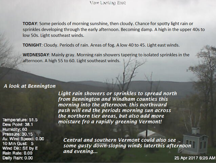
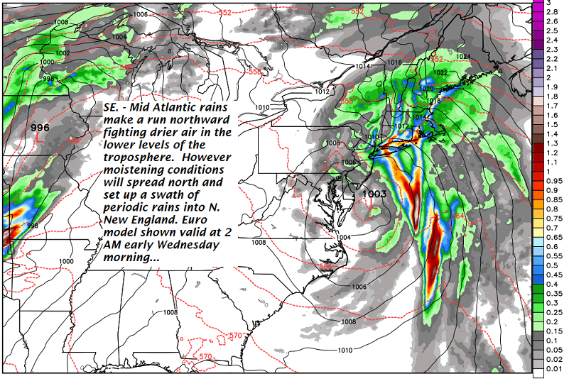
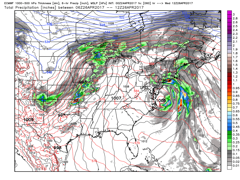
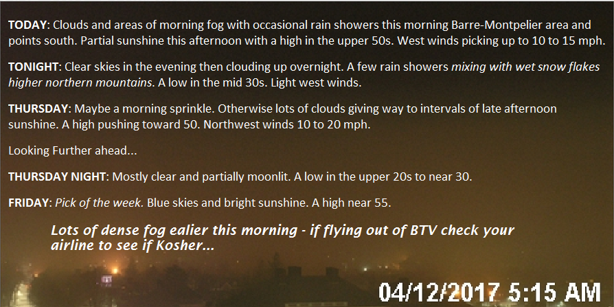
TONIGHT: Cloudy and damp. Periods of rain. Areas of fog. A low 40 to 45. Light east winds.

TOMORROW: Mainly gray. Morning rain showers tapering to isolated sprinkles in the afternoon. A high 55 to 60. Light southeast winds.

WEDNESDAY NIGHT: A threat for a sprinkle eastern areas otherwise cloudy & damp with areas of fog. A low in the upper 40s. Light southeast winds.

THURSDAY: Morning clouds mixing with periods of afternoon sunshine. A high around 65. Southeast breeze 10 mph.

Looking Further ahead…

THURSDAY NIGHT: Partly to mostly cloudy. Patchy valley fog. A low in the mid 50s.

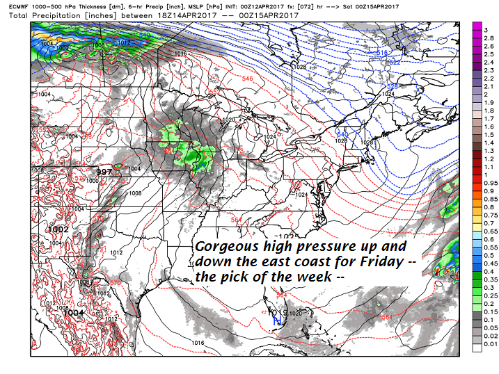
FRIDAY: Clouds with a few breaks of sun. Chance for showers with a risk for a few rumbles of thunder. A high mid to upper 60s.

SATURDAY: Mainly cloudy. Chance for rain showers in the morning exiting in the afternoon. Breezy. A low in the low 40s. A high 60 to 65.

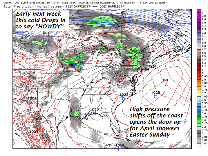
SUNDAY: Mixed clouds and sun. Breezy. A low in the 30s. A 50 to 55.

Average lows 35 to 40. Normal highs around 60.

RH/4-25[end]

Updated Tuesday Morning Forecast — April 25th, 2017

TODAY: Some periods of morning sunshine, then cloudy. Chance for spotty light rain or sprinkles developing through the early afternoon. Becoming damp. A high in the upper 40s to low 50s. Light southeast winds.

TONIGHT: Cloudy. Periods of rain. Areas of fog. A low 40 to 45. Light east winds.

WEDNESDAY: Mainly gray. Morning rain showers tapering to isolated sprinkles in the afternoon. A high 55 to 60. Light southeast winds.

Looking Further ahead…

WEDNESDAY NIGHT: A threat for a sprinkle eastern areas other mostly cloudy. Damp. A low in the upper 40s.

THURSDAY: Morning clouds mixing with periods of afternoon sunshine. A high 65 to 70.

FRIDAY: Mostly cloudy. Chance for showers with a risk for a few rumbles of thunder. A low in the mid 50s. A high in the mid 60s.

SATURDAY: Mainly cloudy. Chance for rain showers in the morning exiting in the afternoon. Breezy. A low in the mid 40s. A high 60 to 65.

SUNDAY: Mixed clouds and sun and breezy. A low in the 30s. A high in the low 50s.

Average lows 35 to 40. Normal highs around 60.

RH/4-25[end]

Updated Monday Evening forecast — April 24th, 2017

TONIGHT: Mostly clear northern areas, otherwise patchy high cloudiness. A low in the 30s. Light east winds.

TOMORROW: Some periods of morning sunshine, then cloudy with a rising chance for spotty light rain or sprinkles. Damp and cool. A high in the upper 40s to low 50s. Light southeast winds.

TUESDAY NIGHT: Cloudy with periods of rain. Areas of fog. A low 40 to 45. Light east winds.

WEDNESDAY: Mainly gray. Morning rain showers tapering to isolated sprinkles in the afternoon. A high in the mid 50s. Light southeast winds.

Looking Further ahead…

WEDNESDAY NIGHT: A threat for a sprinkle eastern areas other mostly cloudy. Damp. A low in the upper 40s to low 50s.

THURSDAY: Mainly cloudy with a breaks of afternoon sun. Possible sprinkles far southern areas, otherwise dry. A high 65 to 70.

FRIDAY: Partly to mostly cloudy. Chance for a shower with a risk for a few rumbles of thunder. A low in the mid 50s. A high in the low 70s.

SATURDAY: Mainly cloudy. Chance for light rain showers. A low in the upper 40s. A high in the mid 60s to low 70s.

Average lows around 35 to 40. Normal highs around 60

RH/4-24[end]

Updated Monday morning forecast — April 24th, 2017

Below – A weak area of low pressure assorted showers will be targeting New England as it rolls northeast up the coast – expect generally damp gray skies but overall – light rainfall.

TODAY: Pick of the week. Partly cloudy for a time this morning, then lots of sunshine this afternoon. A high around 60. A light north wind.

TONIGHT: Variable high cloudiness. A low in the 30s. Light east winds.

TUESDAY: Some periods of morning sunshine then cloudy with a rising chance for light rain or rain showers. Chilly with a high around 50. Light southeast winds.

Looking Further ahead…

TUESDAY NIGHT: Cloudy with periods of light rain. A low 40 to 45.

WEDNESDAY: Mainly gray with an occasional rain shower. A high in the mid 50s.

THURSDAY: Variable cloudiness. Just a threat of a rain shower or two far southern areas, otherwise dry. A low in the mid to upper 40s. A high 65 to 70.

FRIDAY: Partly to mostly cloudy. Chance for a shower with a risk for a thunderstorm. A low in the mid 50s. A high in the low 70s.

SATURDAY: Mainly cloudy. Chance for light rain showers. A low in the 40s. A high in the mid 60s to low 70s.

Average lows around 35 to 40. Normal highs around 60

RH/4-24[end]

Updated Good Friday forecast — April 14th, 2017

TONIGHT: Clear with a few high clouds. A low ranging through the 30s. Light winds.

TOMORROW: Filtered sunshine through increasing high clouds. Clouding up later on with a rising chance for showers especially western areas. Milder. A high in the mid 60s. Southwest winds 10 to 20 mph.

SATURDAY NIGHT: Cloudy. A good chance for rain or rain showers. A low around 50. Southwest winds 10 to 20 mph.

EASTER SUNDAY: Morning showers giving way to breaks of sunshine. Widely scattered showers in the afternoon with a isolated rumble of thunder. A high 70 to 75. Southwest winds 10 to 20 mph.

Looking Further ahead…

SUNDAY NIGHT: Partly to mostly cloudy, with scattered rain showers. Temperatures falling through the 50s.

MONDAY: Scattered rain showers mixed with wet snow flakes northern mountains, otherwise colder with intervals of sun. Temperatures in the upper 40s.

TUESDAY: Mostly sunny. A low in the mid 20s. A high around 50.

WEDNESDAY: Clouding up. Rain showers mixed with wet snow mainly high terrain. Accumulation up to a couple inches wet snow in the higher terrain. A low near 30. A high 40 to 45..

THURSDAY: Scattered rain showers exiting early to increasing sunshine. A low in the mid 30s. A high around 45.

Average lows around 32. Normal highs in the mid 50s

RH/4-14[end]

Updated Friday morning Forecast — April 14th, 2017

TODAY: Mostly sunny and beauty. A high mid 50s. Northwest winds 10 mph.

TONIGHT: Clear with a few high clouds. A low ranging through the 30s. Light winds.

SATURDAY: Filtered morning sunshine early, then clouding up with a rising chance for showers late in the afternoon far northern areas. A high in the mid 60s. Southwest winds 10 to 20 mph.

Looking Further ahead…

SATURDAY NIGHT: Cloudy with a good chance for rain or rain showers mainly northern areas. A low around 50.

EASTER SUNDAY: Morning showers giving way to breaks of sunshine. Widely scattered showers in the afternoon. Maybe an isolated rumble of thunder. A high in the low to mid 70s.

MONDAY: Scattered rain showers mixed with wet snow flakes northern mountains in the morning, otherwise partial clearing but much cooler. Temperatures holding in the mid to upper 40s.

TUESDAY: Mostly sunny. A low in the mid 20s. A high around 50.

WEDNESDAY: Clouding up. Rain showers mixed with wet snow mainly high terrain. Accumulation up to a couple inches wet snow in the higher terrain. A low near 32. A high in the low 40s.

THURSDAY: Scattered rain showers exiting early to increasing sunshine. A low in the 30s. A high in the 40s.

Average lows around 32. Normal highs in the mid 50s

RH/4-14[end]

Updated Thursday Evening Forecast — April 13th, 2017

TONIGHT: Mostly clear and partially moonlit. A low in the upper 20s or around 30. Little wind.

TOMORROW: Pick of the week. Mostly sunny. A high mid 50s. Northwest winds 10 mph.

FRIDAY NIGHT: Clear with a few high clouds. A low ranging through the 30s. Light winds.

SATURDAY: Filtered morning sunshine early, then clouding up with a rising chance for showers late in the afternoon far northern areas. A high in the mid 60s. Southwest winds 10 to 20 mph.

Looking Further ahead…

SATURDAY NIGHT: Cloudy with a good chance for rain or rain showers mainly northern areas. A low around 50.

EASTER SUNDAY: Morning showers giving way to breaks of sunshine. Slight chance for a few more showers in the afternoon. A high in the low to mid 70s.

MONDAY: Scattered rain showers mixed with wet snow flakes northern mountains in the morning, otherwise partly to mostly cloudy. Much cooler. Temperatures holding in the mid to upper 40s.

TUESDAY: Mostly sunny. A low in the mid 20s. A high around 50.

WEDNESDAY: Clouding up. Chance for rain showers in the afternoon. A low near 32. A high in the low to mid 40s

Average lows around 32. Normal highs in the low to mid 50s

RH/4-13[end]

Updated Thursday morning forecast — April 13th, 2017

TODAY: Maybe a morning sprinkle mixed with a few wet snow flakes. Otherwise lots of clouds giving way to intervals of late afternoon sunshine. A high pushing toward 50. Northwest winds 10 to 25 mph.

TONIGHT: Mostly clear and partially moonlit. A low in the upper 20s to near 30. Little wind.

FRIDAY: Pick of the week. Mostly sunny. A high 55 to 60. Northwest winds 10 to 15 mph.

Looking Further ahead…

FRIDAY NIGHT: Clear early then increasing high cloudiness. A low near 32.

SATURDAY: Filtered morning sunshine early, then clouding up with a rising chance for showers last half of the afternoon. A high in the mid 60s.

EASTER SUNDAY: Morning showers giving way to hints of sunshine. Isolated showers northern areas in the afternoon. A low mid 40s to low 50s. A high 70 to 75.

MONDAY: Good chance for showers in the morning…mixed with wet snow flakes, otherwise partly to mostly cloudy. Much cooler. Temperatures holding in the low to mid 40s.

TUESDAY: Mixed sun and clouds. A low in the mid 20s. A high around 50.

Average lows around 32. Normal highs in the low to mid 50s

RH/4-12[end]

Updated Wednesday Evening Forecast — April 12th, 2017

TONIGHT: Partly cloudy this evening, then more clouds with a few rain showers mixing with wet snow flakes higher northern mountains. A low in the mid 30s. Light west winds.

TOMORROW: Maybe a morning sprinkle mixed with a few wet snow flakes. Otherwise lots of clouds giving way to intervals of late afternoon sunshine. A high pushing toward 50. Northwest winds 10 to 25 mph.

THURSDAY NIGHT: Mostly clear and partially moonlit. A low in the upper 20s to near 30. Little wind.

FRIDAY: Pick of the week. Blue skies and bright sunshine. A high near 55. Northwest winds 10 to 15 mph.

Looking Further ahead…

FRIDAY NIGHT: Clear early then increasing high cloudiness. A low near 32.

SATURDAY: Filtered morning sunshine early, then clouding up with a rising chance for rain or showers last half of the afternoon. A high in the low to mid 60s.

EASTER SUNDAY: Clouds with a few hints of sunshine. “April showers” off and on were likely. A low 45 to 50. A high in the mid 60s.

MONDAY: Scattered morning sprinkles mixed with a wet snow flakes, otherwise partly to mostly cloudy. Much cooler. Temperatures holding in the low to mid 40s.

TUESDAY: Mixed sun and clouds. A low in the 20s. A high in the mid 40s.

Average lows around 32. Normal highs in the low to mid 50s

RH/4-12[end]

Updated Wednesday morning forecast — April 12th, 2017

TODAY: Clouds and areas of morning fog with occasional rain showers this morning Barre-Montpelier area and points south. Partial sunshine this afternoon with a high in the upper 50s. West winds picking up to 10 to 15 mph.

TONIGHT: Clear skies in the evening then clouding up overnight. A few rain showers mixing with wet snow flakes higher northern mountains. A low in the mid 30s. Light west winds.

THURSDAY: Maybe a morning sprinkle. Otherwise lots of clouds giving way to intervals of late afternoon sunshine. A high pushing toward 50. Northwest winds 10 to 20 mph.

Looking Further ahead…

THURSDAY NIGHT: Mostly clear and partially moonlit. A low in the upper 20s to near 30.

FRIDAY: Pick of the week. Blue skies and bright sunshine. A high near 55.

SATURDAY: Filtered sunshine through high cloudiness thickening up late leading to a chance for showers Saturday evening. A low near 32. A high in the low to mid 60s

SUNDAY: Cloudy and gray. Chance for “April showers”. A low 45 to 50. A high in the mid 60s.

MONDAY: Much cooler. Scattered rain showers mixed with wet snow flakes in the hills in the morning. Temperatures holding in the low to mid 40s.

TUESDAY: Partly to mostly cloudy and A low in the 20s. A high in the mid 40s .

Average lows around 32. Normal highs in the low to mid 50s

RH/4-12[end]