Updated Monday Morning Forecast — May 15th, 2017

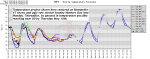
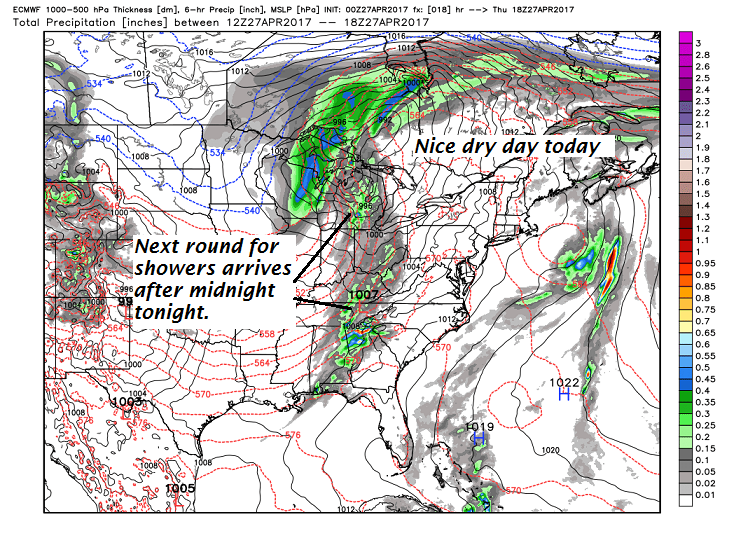
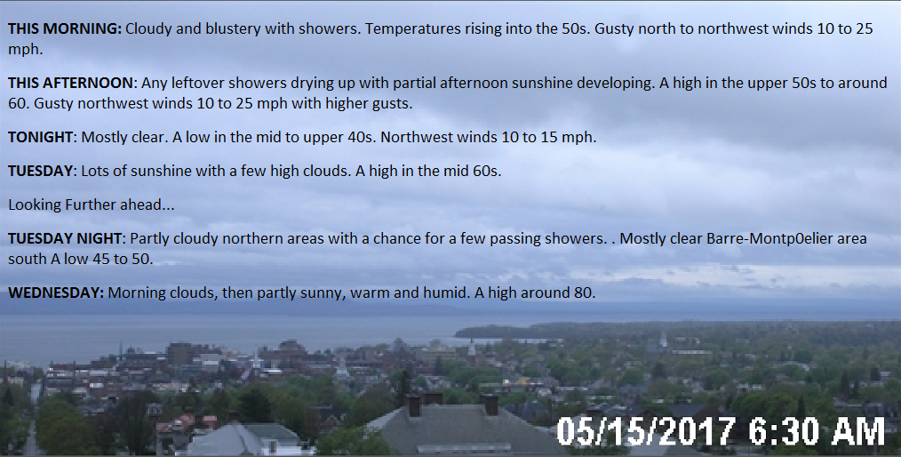
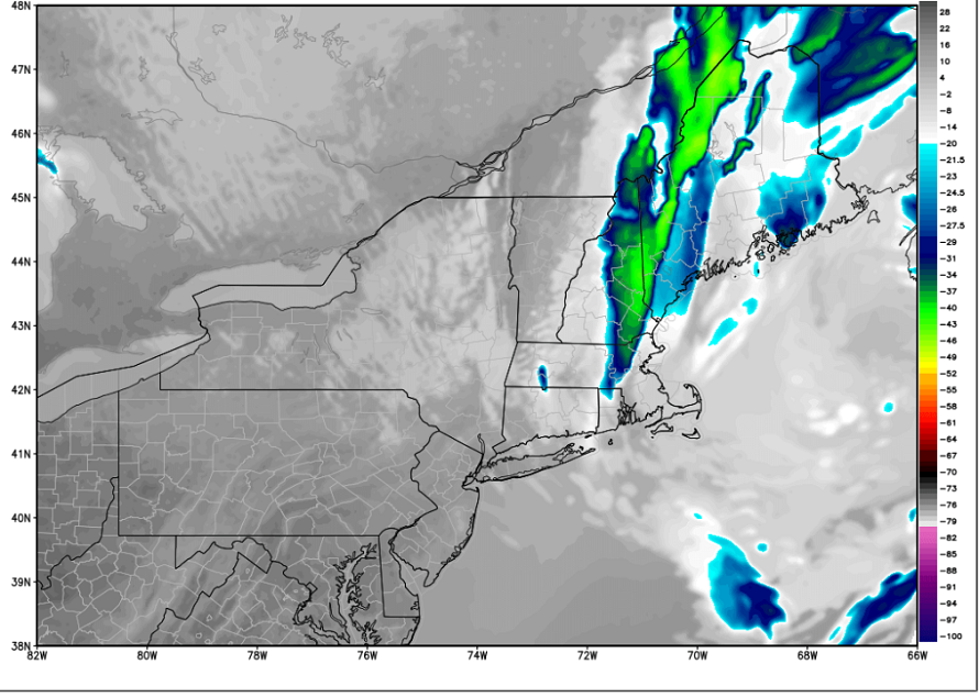
THIS MORNING: Cloudy and blustery with showers. Temperatures rising into the 50s. Gusty north to northwest winds 10 to 25 mph.

THIS AFTERNOON: Any leftover showers drying up with partial afternoon sunshine developing. A high in the upper 50s to around 60. Gusty northwest winds 10 to 25 mph with higher gusts.

TONIGHT: Mostly clear. A low in the mid to upper 40s. Northwest winds 10 to 15 mph.

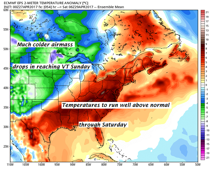
TUESDAY: Lots of sunshine with a few high clouds. A high in the mid 60s. Northwest breeze 10 to 15 mph.

Looking Further ahead…

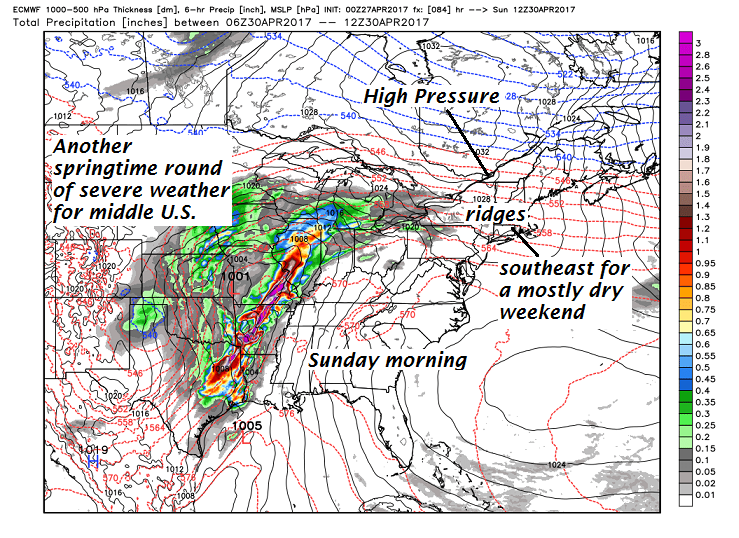
TUESDAY NIGHT: Partly cloudy northern areas with a chance for a few passing showers. Mostly clear Barre-Montp0elier area south A low 45 to 50.

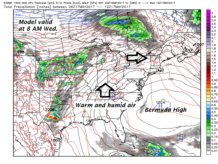
WEDNESDAY: Morning clouds, then partly sunny, warm and humid. A high around 80.

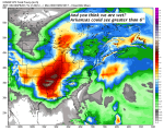
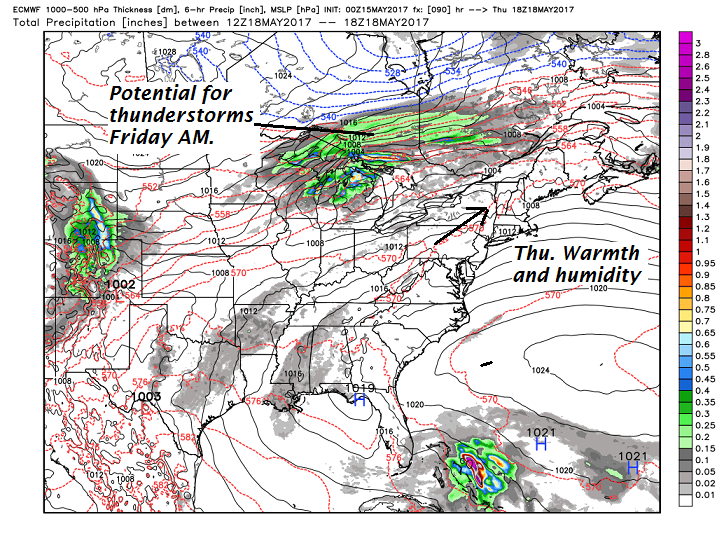
THURSDAY: Partly to mostly sunny. Slight chance for a late day shower or thundershower. A low in the low 60s. A high 80 to 85.

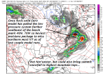
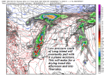
FRIDAY: Warm and humid start with scattered showers and possible thunderstorms early, then increasingly sunny and blustery. Temperatures in the low 60s early, falling through the 50s in the afternoon. Gusty northwest winds.

Average low 40 to 45. Normal high in the mid to upper 60s.

RH/5-15[end]

Updated Friday evening forecast — May 12th, 2017

TONIGHT: Mostly clear and moonlit. Patchy valley fog. A low in the upper 30s to low 40s. Light southeast winds.

TOMORROW: Brief morning sun then clouding up. A rising likelihood for periods of rain or showers developing in the afternoon. A high 55 to 60. Southeasterly breeze 10 mph.

SATURDAY NIGHT: Periods of rain or showers…possibly moderate at times. A low 40 to 45. Sight southeast winds.

SUNDAY MOTHERS DAY: Overcast and raw. Periods of rain or showers…possibly moderate at times in the morning. Widely scattered showers in the afternoon. A high upper 40s to around 50. Light winds.

Looking Further ahead…

SUNDAY NIGHT: Cloudy with showers likely. A low 40 to 45.

MONDAY: Cloudy & blustery, continued raw with frequent showers likely. A high in the low 50s. Gusty northwest winds.

TUESDAY: Morning clouds giving way to increasing sunshine. A low 40 to 45. A high in the low 60s.

WEDNESDAY: Chance for a morning shower, otherwise partial afternoon sunshine and much milder. A low 40 to 45. A high in the mid to upper 70s.

THURSDAY: Sunshine giving way to lots of clouds. A rising chance for showers and possible thunderstorms. A low 55 to 60. A high in the 70s.

Average low in the low 40s. Normal high in the mid 60s.

RH/5-11[end]

Updated Friday morning Forecast — May 12th, 2017

TODAY: “Pick of the week.”Some partial morning sun then more clouds this afternoon.A high in the low 60s. Light southeast winds.

TONIGHT: Mostly clear and moonlit. Patchy valley fog. A low in the upper 30s to low 40s. Light southeast winds.

SATURDAY: Brief morning sun then clouding up. A rising likelihood for periods of rain or showers developing in the afternoon. A high 55 to 60. Southeasterly breeze 10 mph.

Looking Further ahead…

SATURDAY NIGHT: Periods of rain…possibly moderate at times. A low in the low 40s.

SUNDAY MOTHERS DAY: Overcast and raw. Periods of rain…possibly moderate at times in the morning tapering to scattered afternoon showers. A high in the mid to upper 40s.

MONDAY: Cloudy & blustery, continued raw with frequent showers likely. A low in the in the low 40s. A high in the low 50s. Gusty northwest winds.

TUESDAY: Morning clouds giving way to increasing sunshine. A low 40 to 45. A high around 60.

WEDNESDAY: Chance for a morning shower, otherwise partial afternoon sunshine and much milder. A low 40 to 45. A high in the 70s.

Average low in the low 40s. Normal high in the mid 60s.

RH/5-11[end]

Updated Thursday Evening forecast — May 11th, 2017

TONIGHT: Partially moonlit. A low 35 to 40. Light east winds.

TOMORROW: “Pick of the week.”Breaks of sun in the morning, but with cloudy periods in the afternoon. A high in the low 60s. Light southeast winds.

FRIDAY NIGHT: Mostly clear and moonlit. Patchy valley fog. A low near 40. Light southeast winds.

SATURDAY: Brief morning sun then clouding up. A rising likelihood for periods of rain or showers developing in the afternoon. A high 55 to 60. Southeasterly breeze 10 mph.

Looking Further ahead…

SATURDAY NIGHT: Periods of rain…possibly moderate at times. A low in the low 40s.

SUNDAY MOTHERS DAY: Overcast and raw. Periods of rain…possibly moderate at times in the morning tapering to scattered afternoon showers. A high in the upper 40s.

MONDAY: Cloudy & blustery, continued raw with frequent showers likely. A low in the in the low 40s. A high in the upper 40s to low 50s. Gusty northwest winds.

TUESDAY: Morning clouds giving way to increasing sunshine. A low 40 to 45. A high around 60 to 65.

WEDNESDAY: Chance for a morning shower, otherwise partial afternoon sunshine and much milder. A low in the mid 40s. A high in the mid 70s.

Average low in the low 40s. Normal high in the mid 60s.

RH/5-11[end]

Updated Friday Evening forecast — April 28th, 2017

TONIGHT: Fair early then more clouds overnight. Patchy valley fog. A low upper 40s to mid 50s. Light south wind.

TOMORROW: Scattered showers early toward Rutland. Otherwise morning clouds giving way to periods of sunshine. Turning breezy. A high close to 70…cooler quickly in the afternoon. Gust west to northwest winds picking up 10 to 25 mph.

SATURDAY NIGHT: A few clouds otherwise fair and chilly with pockets of frost. A low in the low to mid 30s. Light north winds.

SUNDAY: Morning sunshine then variable cloudy. Scattered showers developing late in the day from west to east. A high in the 50s. Little wind.

Looking Further ahead…

SUNDAY NIGHT: Cloudy with occasional showers…heavy at times far northern areas. A low around 40.

MONDAY: Mostly cloudy. Chance for showers and possibly a thunderstorm early. A lingering shower far northern areas then intervals of sun. Breezy to windy at times. A high in the 50s but warmer western areas in the 60s.

TUESDAY: Clouds mixing with intervals of sun. Scattered showers. A low in the mid 40s. A high in the low 60s.

WEDNESDAY: Considerable clouds with a chance for showers.A low in the low to mid 40s. A high in the low to mid 50s.

Average lows 35 to 40. Normal highs around 60.

RH/4-28[end]

Roger Hill

Weathering Heights Consulting

186 MacKenzie Dr.

Worcester VT 05682

icon-envelope-tick-round-orange-animated-no-repeat-v1.gif Virus-free. www.avast.com

Updated Friday morning forecast — April 28th, 2017

TODAY: Any morning showers giving way to partial sunshine especially for the afternoon. Again very mild with a high in the low 70s. Wind becoming southwesterly 10 to 15 mph.

TONIGHT: Scattered clouds. Patchy valley fog. A low upper 40s to mid 50s. Light south wind.

SATURDAY: Mixed clouds and sun. Breezy. A high in the mid 60s to low 70s turning cooler later in the afternoon. Northwest winds 10 to 25 mph.

Looking Further ahead…

SATURDAY NIGHT: A few clouds otherwise fair and chilly with pockets of frost. A low in the low to mid 30s.

SUNDAY: Morning sunshine then variable cloudy. Scattered showers developing late in the day from west to east. A high 55 to 60.

MONDAY: Mostly cloudy. Chance for showers and possibly a thunderstorm early. Chance for showers lingering far northern areas otherwise partial clearing. Breezy to windy at times. A low around 40. A high in the low to mid 50s.

TUESDAY: Clouds mixing with periods of sun. Scattered showers. A low in the mid 40s. A high 65 to 70.

WEDNESDAY: A low in the low to mid 40s. A high in the low to mid 50s.

Average lows 35 to 40. Normal highs around 60.

RH/4-28[end]

Updated Thursday Evening forecast — April 27th, 2017

TONIGHT: Cloudy or becoming so. An occasional shower developing overnight. A low in the mid 50s. Southeast winds 10 to 15 mph.

TOMORROW: Threat for a morning shower. Partial afternoon sunshine developing. A high in the low 70s. Wind becoming southwesterly 10 to 15 mph.

FRIDAY NIGHT: Scattered clouds. patchy valley fog. A low 50 to 55. Light south winds.

SATURDAY: Mixed clouds and sun. Breezy. A high in the upper 60s to low 70s turning cooler later in the afternoon. Northwest winds 10 to 25 mph.

Looking Further ahead…

SATURDAY NIGHT: A few clouds otherwise fair and chilly with pockets of frost. A low in the low to mid 30s.

SUNDAY: Morning sunshine then variable cloudy. Scattered showers developing late in the day from west to east. A high 55 to 60.

MONDAY: Mostly cloudy. Chance for showers and possibly a thunderstorm early then partial clearing and breezy to windy at times. A low around 40. A high in the low to mid 50s.

TUESDAY: Clouds mixing with periods of sun. Scattered showers. A low in the mid 40s. A high 65 to 70.

Average lows 35 to 40. Normal highs around 60.

RH/4-27[end]

Updated Thursday morning Forecast — April 27th, 2017

TODAY: Morning clouds mixing with periods of afternoon sunshine. A high mid 60s to near 70. Southeast breeze 10 mph.

TONIGHT: Becoming cloudy. A good chance for showers developing after midnight. A low in the mid 50s. Southeast winds 10 to 15 mph.

FRIDAY: Threat for a morning shower. Partial afternoon sunshine and mild. A high in the low 70s. Wind becoming southwesterly 10 to 15 mph.

Looking Further ahead…

FRIDAY NIGHT: Partly cloudy. A low in the upper 40s to mid 50s.

SATURDAY: Mixed clouds and sun. Breezy. A high in the upper 60s to low 70s.

SUNDAY: Morning sunshine then variable clouds later on. Widely scattered showers toward southern areas late. A low in the low to mid 30s. A high 55 to 60.

MONDAY: Mostly cloudy. Chance for showers early exiting in the afternoon. Breezy to windy at times. A low around 40. A high in the upper 40s to low 50s.

TUESDAY: Scattered showers. Clouds mixing with periods of afternoon sun. A low in the mid 40s. A high in the 60s.

Average lows 35 to 40. Normal highs around 60.

RH/4-27[end]

Updated Wednesday evening forecast — April 26th, 2017

TONIGHT: A threat for a sprinkle eastern areas otherwise cloudy & damp with areas of valley fog. A low in the upper 40s. Light southeast winds.

TOMORROW: Morning clouds mixing with periods of afternoon sunshine. A high around 65. Southeast breeze 10 mph.

THURSDAY NIGHT: Becoming cloudy. A good chance for showers developing after midnight. A low in the mid 50s. Southeast winds 10 to 15 mph.

FRIDAY: Threat for a morning shower. Partial afternoon sunshine and mild. A high upper 60s to low 70s. Wind becoming southwesterly 10 to 15 mph.

Looking Further ahead…

FRIDAY NIGHT: Partly cloudy. A low in the upper 40s to near 50.

SATURDAY: Mixed clouds and sun. Breezy. A high in the upper 60s to around 70.

SUNDAY: Morning sunshine then variable clouds later on. A low in the 30s. A high 55 to 60.

MONDAY: Mostly cloudy. Chance for showers early exiting in the afternoon. Breezy to windy at times. A low around 40. A high in the mid 50s.

TUESDAY: Scattered showers. Clouds mixing with periods of afternoon sun. A low 45 to 50. A high in the 60s.

Average lows 35 to 40. Normal highs around 60.

RH/4-26[end]

Updated Wednesday morning Weather — April 26th, 2017

TODAY: Mainly gray. Morning rain showers tapering to isolated sprinkles this afternoon. A few breaks of sun possible this afternoon. A high in the upper 50s to low 60s. Light southeast winds.

TONIGHT: A threat for a sprinkle eastern areas otherwise cloudy & damp with areas of fog. A low in the upper 40s. Light southeast winds.

THURSDAY: Morning clouds mixing with periods of afternoon sunshine. A high around 65. Southeast breeze 10 mph.

Looking Further ahead…

THURSDAY NIGHT: Partly to mostly cloudy. Patchy valley fog. A low in the mid 50s.

FRIDAY: Clouds with a few breaks of sun. A round of morning showers, with a risk for a few rumbles of thunder. Partial clearing in the afternoon. A high mid to upper 60s.

SATURDAY: Chance for rain showers northern areas early then partly sunny. Breezy. A low 45 to 50. A high in the 60s.

SUNDAY: More clouds than sun. A low in the 30s. A high 55 to 60.

MONDAY: Mostly cloudy. Chance for showers early exiting in the afternoon. Breezy to windy at times. A low around 40. A high in the 50s.

TUESDAY: Slight chance for a shower. Clouds mixing with periods of sun. A low around 50. A high in the 60s.

Average lows 35 to 40. Normal highs around 60.

RH/4-26[end]