Updated Monday morning forecast — May 22nd, 2017

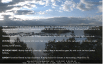
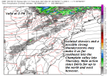
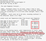
TODAY: Periods of rain or showers dry up for a time this morning. More showers this afternoon, otherwise cloudy and gray. A high temperature low to mid 50s. Northwest winds 10 to 15 mph.

TONIGHT: Cloudy. Showers this evening, exiting overnight to partial clearing. Patchy valley fog. A low 40 to 45. Light northwest winds.

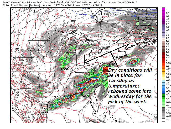
TUESDAY: Clouds with periods of filtered sunshine. A high 65 to 70. Light west breeze.

Looking further ahead…

TUESDAY NIGHT: Fair with variable high cloudiness. A low in the mid 40s.

WEDNESDAY: Pick of the week. Sunshine filtered through variable high cloudiness. A high in the low 70s.

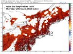
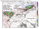
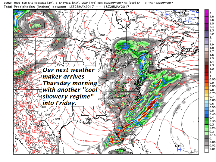
THURSDAY: Cloudy & becoming damp. A rising chance for showers. A low in the upper 40s to low 50s. A high in the low to mid 60s.

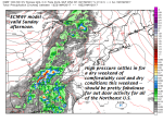
FRIDAY: Gray and chilly. Chance for rain or showers. A low in the mid 40s. A high in the mid 50s.

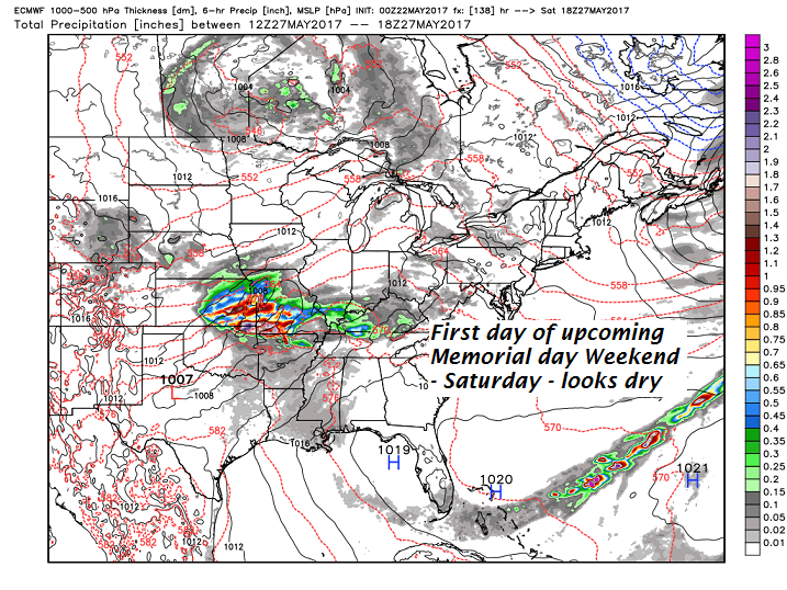
SATURDAY: Clouds mixed with periods of sun. A low in the 40s. A high in the 60s.

Average low in the upper 40s to around 50. Normal high in the upper 60s to low 70s.

RH/5-22[end]

Virus-free. www.avast.com

Updated Friday Evening forecast — May 19th, 2017

TONIGHT: Becoming mostly clear with a few high clouds. A low 35 to 40. A slight risk for frost in the colder NE. Kingdom hollows. Light north wind.

TOMORROW: Some high cloudiness in the morning then bright and sunny but chilly. A high around 60. Light north winds.

SATURDAY NIGHT: Mainly clear with a few high clouds. A low in the 30s with pockets for frost mainly coldest hollows. Little wind.

SUNDAY: Sunshine filtered by high cloudiness through mid afternoon, then thickening clouds. A high 65 to 70. Light southeast winds.

Looking further ahead…

SUNDAY NIGHT: Cloudy. Showers becoming likely. A low in the mid 40s.

MONDAY: Cloudy. Periods of rain or showers mainly in the morning. A high in the 50s.

TUESDAY: Clouds with a few intervals of sun. A low 40 to 45. A high in the mid to upper 60s.

WEDNESDAY: Partial sunshine giving way to more clouds late. A low in the 40s. A high in the upper 60s.

THURSDAY: Mainly cloudy. Chance for showers. A low in the 40s. A high upper 50s to low 60s.

Average low around 45 Normal high in the upper 60s.

RH/5-19[end]

Updated Friday morning Forecast — May 19th, 2017

TODAY: Some partial brief morning sun then mostly cloudy. Few widely scattered showers to move through exiting this afternoon to partial late day sun. Temperatures in the 60s this morning gradually falling. Northwest winds pick up 10 to 20 mph.

TONIGHT: Mostly clear. A low 35 to 40. A slight risk for frost in the colder NE. Kingdom hollows. Light north wind.

SATURDAY: Partly to mostly sunny with some high cloudiness. A high in the low 60s. Light north to northwest winds.

Looking further ahead…

SATURDAY NIGHT: Mainly clear with a few high clouds. A low in the mid to upper 30s with a risk for frost coldest hollows.

SUNDAY: Sunshine filtered by high cloudiness. A rising chance for showers in the evening. A high 65 to 70.

MONDAY: Cloudy. Periods of rain or showers. A low 45 to 50. A high in the upper 50s to low 60s

TUESDAY: Clouds with a few intervals of sun. A low 40 to 45. A high in the upper 60s.

WEDNESDAY: Mixed sun and clouds. A low in the 40s. A high 65 to 70.

Average low around 45 Normal high in the upper 60s.

RH/5-19[end]

Updated Thursday Evening forecast — May 18th, 2017

Severe thunderstorm Watch in effect through 11 PM tonight.

TONIGHT: Variably cloudy. Scattered showers and a few potentially strong to locally severe thunderstorms developing into the overnight. Strong gusty winds, small hail and briefly heavy rainfall were possible. A low 55 to 60. Southwest winds shifting to westerly 10 mph.

TOMORROW: A cloudy muggy start with showers & a risk for thunder early. Showers exiting in the afternoon to partial clearing. Much cooler & less humid by late in the day as temperatures fall from the mid 60s into the 50s. Northwest winds 10 to 20 mph in the afternoon.

FRIDAY NIGHT: Mostly clear. A low in mid 30s to around 40. A slight risk for frost in the colder NE. Kingdom hollows. Wind becoming light from north.

SATURDAY: Partly to mostly sunny with some high cloudiness. A high in the low 60s. Light north to northwest winds.

Looking further ahead…

SATURDAY NIGHT: A low in the mid to upper 30s with a risk for frost coldest hollows.

SUNDAY: Sunshine filtered by high cloudiness. A rising chance for showers in the evening. A high around 70.

MONDAY: Cloudy. Good chance for showers. A low in the 40s. A high in the low to mid 60s.

TUESDAY: Clouds mixing with periods of afternoon sun. A low in the low to mid 40s. A high in the upper 60s.

Average low 40 to 45. Normal high in the mid to upper 60s.

RH/5-18[end]

Updated Thursday morning forecast — May 18th, 2017

TODAY: Partly to mostly sunny, with near record breaking highs possible again today. Sticky. A rising chance for late day showers and thunderstorms, one or two “possibly strong to severe” toward the Champlain valley. A high upper 80s to low 90s. Southwest winds 10 to 15 mph.

TONIGHT: Variably cloudy. Scattered showers and a few thunderstorms. A low 55 to 60. Southwest winds shifting to westerly 10 mph.

FRIDAY: A cloudy muggy start with showers & a risk for thunder early. Showers exiting in the afternoon to partial clearing. Much cooler & less humid by late in the day as temperatures fall from the mid 60s into the 50s. Northwest winds 10 to 20 mph in the afternoon.

Looking further ahead…

FRIDAY NIGHT: Mostly clear. A low in mid 30s to low 40s. A slight risk for frost in the colder NE. Kingdom hollows.

SATURDAY: Partly to mostly sunny with some high cloudiness. A high around 60.

SUNDAY: Sunshine filtered by high cloudiness. A rising chance for showers in the evening. A low in the mid to upper 30s. A high around 70.

MONDAY: Cloudy. Good chance for showers. A low in the 40s. A high in the low to mid 60s.

TUESDAY: Clouds mixing with periods of afternoon sun. A low in the low to mid 40s. A high in the upper 60s.

Average low 40 to 45. Normal high in the mid to upper 60s.

RH/5-18[end]

Updated Wednesday evening forecast — May 17th, 2017

TONIGHT: Clear with some patchy high clouds. A bit on the muggy side with a low near 60. Light southwest winds.

TOMORROW: Partly to mostly sunny. Summer-like in temperature and muggy. An Isolated late day showers and thunderstorm especially toward the Champlain valley. A high in the mid to upper 80s. Southwest winds 10 to 15 mph.

THURSDAY NIGHT: Mostly cloudy. Scattered showers and a few thunderstorms. A low 55 to 60. Southwest winds shifting to westerly 10 mph.

FRIDAY: A muggy start with clouds & scattered showers. A risk for thunder in the morning. Becoming partly sunny,blustery and refreshingly less humid later in the day. A high in the mid 60s. Gusty northwest winds 10 to 20 mph in the afternoon.

Looking further ahead…

FRIDAY NIGHT: Mostly clear. A low in mid 30s with the risk for frost in the colder hollows.

SATURDAY: Partly to mostly sunny with some high cloudiness. A high around 60.

SUNDAY: Sunshine filtered by high cloudiness. A rising chance for showers in the evening. A low in the mid to upper 30s. A high around 70.

MONDAY: Cloudy. Good chance for showers. A low in the 40s. A high in the low to mid 60s.

TUESDAY: Clouds mixing with periods of afternoon sun. A low in the low to mid 40s. A high in the upper 60s.

Average low 40 to 45. Normal high in the mid to upper 60s.

RH/5-17[end]

Updated Wednesday morning forecast — May 17th, 2017

TODAY: Morning cloudiness and sprinkle or two to give3 way to partly to mostly sunny warm and a bit humid. A high 80 to 85. Southwest breeze 10 to 15 mph.

TONIGHT: Clear with some patchy high clouds. A bit on the muggy side with a low near 60. Light southwest winds.

THURSDAY: Partly to mostly sunny. Summer-like in temperature and muggy. An Isolated late day shower or thunderstorm toward the Champlain valley. A high in the mid to upper 80s. Southwest winds 10 to 15 mph.

Looking further ahead…

THURSDAY NIGHT: Scattered showers and a few thunderstorms. A low 55 to 60.

FRIDAY: A muggy start with clouds & scattered showers. A risk for thunder in the morning. Becoming partly to mostly sunny,and blustery in the afternoon. Refreshingly less humid. A high in the low to mid 60s. Gusty northwest winds in the afternoon.

SATURDAY: Partly to mostly sunny. A low in the mid 30s with a risk for pockets of frost colder hollows. A high 60 to 65.

SUNDAY: Sunshine filtered by high cloudiness. A rising chance for showers in the evening. A low in the mid to upper 30s. A high in the lower 70s.

Average low 40 to 45. Normal high in the mid to upper 60s.

RH/5-17[end]

Updated Tuesday evening forecast — May 16th, 2017

TONIGHT: Variable clouds. Maybe a sprinkle toward morning. A low in the mid to upper 40s. Light winds.

TOMORROW: A few morning clouds with a chance for a shower or two northern areas, then partly to mostly sunny warm and a bit humid. A high near 80. Southwest breeze 10 to 15 mph.

WEDNESDAY NIGHT: Clear with some patchy high clouds. A bit on the muggy side with a low near 60. Light southwest winds.

THURSDAY: Partly to mostly sunny. Summer-like in temperature and rather sticky. An Isolated late day shower or thundershower far northern areas. A high in the mid 80s. Southwest winds 10 to 15 mph.

Looking further ahead…

THURSDAY NIGHT: Scattered showers and a few thunderstorms. A low in the upper 50s to low 60s.

FRIDAY: A muggy start with scattered showers and thunderstorms, mainly in the morning. Partly to mostly sunny,and blustery in the afternoon becoming less humid and cooler. An early high in the upper 60s. Gusty northwest winds in the afternoon.

SATURDAY: Partly to mostly sunny. A low in the mid 30s with a risk for pockets of frost colder hollows. A high 60 to 65.

SUNDAY: Partly sunny then more clouds in the afternoon. A rising chance for showers in the evening. A low in the mid to upper 30s. A high near 70.

Average low 40 to 45. Normal high in the mid to upper 60s.

RH/5-16[end]

Updated Tuesday morning forecast — May 16th, 2017

TODAY: Partly to mostly sunny. A high in the mid 60s. Northwest breeze 10 to 15 mph.

TONIGHT: Partly cloudy. Chance for a few sprinkles toward morning. A low in the mid to upper 40s. Light winds.

WEDNESDAY: Morning clouds with isolated showers exiting northern tier area. Partly sunny, warm and increasingly humid in the afternoon with a high near 80. Southwest breeze 10 to 20 mph.

Looking Further ahead…

WEDNESDAY NIGHT: Clear with a few high clouds. a bit muggy with a low around 60.

THURSDAY: Partly to mostly sunny. An Isolated late day shower or thundershower. A high in the mid 80s.

FRIDAY: Warm and humid start with scattered showers and thunderstorms, mainly in the morning. Partly to mostly sunny,and blustery in the afternoon becoming less humid and cooler. An early high in the upper 60s. Gusty northwest winds in the afternoon.

SATURDAY: Partly to mostly sunny. A low in the mid to upper 30s. A high 60 to 65.

SUNDAY: Partly sunny then more clouds in the afternoon. A rising chance for showers in the evening. A low in the mid 30s to around 40. A high in the mid 60s.

Average low 40 to 45. Normal high in the mid to upper 60s.

RH/5-16[end]

Updated Monday Evening forecast — May 15th, 2017

TONIGHT: Early evening cloudiness then mostly clear. A low in the mid to upper 40s. Northwest winds 10 mph.

TOMORROW: Lots of sunshine with a few high clouds. A high in the mid 60s. Northwest breeze 10 to 15 mph.

TUESDAY NIGHT: Partly cloudy. Chance for a few sprinkles toward morning. A low 45 to 50. Light winds.

WEDNESDAY: Morning clouds with isolated showers exiting. Partly sunny, warm and increasingly humid in the afternoon with a high near 80. Southwest breeze 10 to 20 mph.

Looking Further ahead…

WEDNESDAY NIGHT: Clear with a few high clouds. a bit muggy with a low around 60.

THURSDAY: Partly to mostly sunny. Slight chance for a late day shower or thundershower. A high in the low to mid 80s.

FRIDAY: Warm and humid start with scattered showers and possible thunderstorms early, then increasingly sunny and blustery. Temperatures in the low 60s early, falling through the 50s in the afternoon. Gusty northwest winds.

SATURDAY: Partly to mostly sunny. A low in the 40s. A high 60 to 65.

Average low 40 to 45. Normal high in the mid to upper 60s.

RH/5-15[end]