
-

- image00110
-
- image00211
-
- image00310
-
- image0046
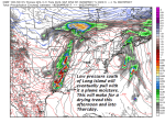
TODAY: Mainly gray. Morning rain showers tapering to isolated sprinkles this afternoon. A few breaks of sun possible this afternoon. A high in the upper 50s to low 60s. Light southeast winds.
TONIGHT: A threat for a sprinkle eastern areas otherwise cloudy & damp with areas of fog. A low in the upper 40s. Light southeast winds.
THURSDAY: Morning clouds mixing with periods of afternoon sunshine. A high around 65. Southeast breeze 10 mph.
Looking Further ahead…
THURSDAY NIGHT: Partly to mostly cloudy. Patchy valley fog. A low in the mid 50s.
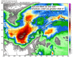
FRIDAY: Clouds with a few breaks of sun. A round of morning showers, with a risk for a few rumbles of thunder. Partial clearing in the afternoon. A high mid to upper 60s.
SATURDAY: Chance for rain showers northern areas early then partly sunny. Breezy. A low 45 to 50. A high in the 60s.
SUNDAY: More clouds than sun. A low in the 30s. A high 55 to 60.
MONDAY: Mostly cloudy. Chance for showers early exiting in the afternoon. Breezy to windy at times. A low around 40. A high in the 50s.
TUESDAY: Slight chance for a shower. Clouds mixing with periods of sun. A low around 50. A high in the 60s.
Average lows 35 to 40. Normal highs around 60.
RH/4-26[end]
