Updated Friday Morning Forecast — May 28th, 2021

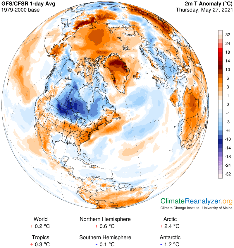
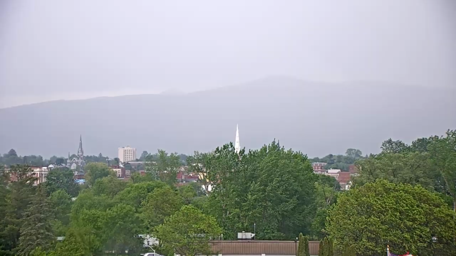
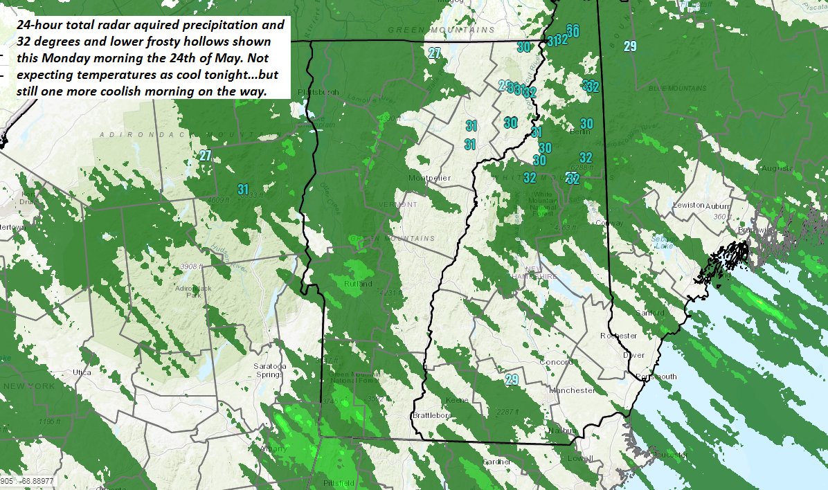
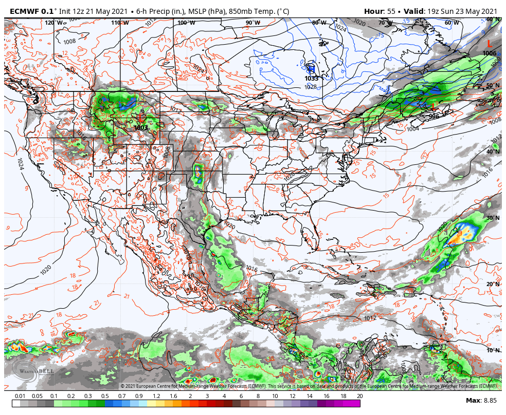
TODAY: Thickening clouds and chilly with frost northern hollows early. Some light showers developing toward Rutland late. Well below normal in temperature. A high around 55. Light northwest winds.

TONIGHT:Cloudy. Showers likely southern portions. A low ranging 35 to 40.Light northeast winds.

SATURDAY: Gray skies early gives way to filtered sunshine through high clouds. Scattered morning showers far southern areas exits. Dry & still cool otherwise. A high upper 50s to near 60. Light northeast winds.

Looking further ahead…

SATURDAY NIGHT: Mostly clear northern areas in the evening giving way to more clouds overnight. A low in the mid-30s, with pockets of frost possible northern areas.

SUNDAY: Considerable cloudiness. Scattered light showers southern areas overspreading most of the region. Very chilly. A high in the low to mid 50s.

MONDAY MEMORIAL DAY: Lots of clouds giving way to late day sunshine. Milder trend. A low around 45. Warmer. A high mid-60s.

TUESDAY: Morning clouds then intervals of afternoon sun. A low around 45. A high in the lower 70s.

WEDNESDAY: Mixed sun and clouds. A low around 45. A high in the mid-70s.

Average low upper 40s to low 50s. Average highs upper 60s to mid-70s.

Start of Meteorological Summer June 6th… Summer peaks approx.. July 22nd based off local climatology.

RH/5-28forecast][end]

Updated Thursday Evening Forecast — May 27th, 2021

TONIGHT: Mostly clear & moonlit with a few high clouds overnight. A low mid-30s to around 40. Isolated frost possible northern hollows. Light north to northwest winds.

TOMORROW: Thickening clouds and rather chilly. Chance for light showers south of the Barre-Montpelier area developing late. Rather cool. A high around 55. Light northwest winds.

FRIDAY NIGHT:Cloudy. Showers likely southern portions. A low ranging upper 30s to low 40s.Light northeast winds.

SATURDAY: Gray skies early gives way to filtered sunshine through high clouds. Chance for showers far south early. Dry but still cool. A high upper 50s to around 60. Light northeast winds.

Looking further ahead…

SATURDAY NIGHT: Mostly clear northern areas high clouds south. A low 35 to 40. Isolated frost possible northern hollows.

SUNDAY: Sunshine then some afternoon clouds. Cool. A high in the mid-60s.

MONDAY MEMORIAL DAY OUTLOOK: Lots of clouds. Chance for showers. Partial clearing late. A low around 45. A high 65 to 70.

TUESDAY: Mostly cloudy with intervals of afternoon sun. A low around 45. A high in the lower 70s.

Average low mid-40s to around 50. Average highs upper 60s to lower 70s.

Start of Meteorological Summer June 6th… Summer peaks approx.. July 22nd based off local climatology.

RH/5-27forecast][end]

Updated Thursday Morning Forecast — May 27th, 2021

TODAY: An early sprinkle northern areas, then sunshine mixed with high clouds this afternoon. A bit blustery. A high 60 to 65. North to northwest winds 10 to 20 mph.

TONIGHT: Mostly clear partially moonlit skies gives way high cloudiness. A low mid-30s to around 40. Isolated frost possible northern hollows. Light north winds.

FRIDAY: Gray and rather chilly. Chance for light showers south of the Barre-Montpelier area in the afternoon. Rather cool. A high in the low to mid 50s. Light northwest winds.

Looking further ahead…

FRIDAY NIGHT:Cloudy. Chance for lingering showers southern areas. A low 35 to 40…coldest northern hollows.

SATURDAY: Gray skies early gives way to filtered sunshine through high clouds Dry but still cool. A high upper 50s to around 60.

SUNDAY: Sunshine then some afternoon clouds. Cool. A low mid-30s to around 40. A high around 65.

MONDAY MEMORIAL DAY OUTLOOK: Considerable cloudiness. Chance for showers. Partial clearing in the afternoon. A low around 45. A high around 65.

TUESDAY: Clouds mixing with periods of sun. A low 45 to 50. A high low to mid 70s.

Average low mid-40s to around 50. Average highs upper 60s to lower 70s.

Start of Meteorological Summer June 6th… Summer peaks approx.. July 22nd based off local climatology.

RH/5-27forecast][end]

Updated Wednesday Evening Forecast — May 26th, 2021

Severe Thunderstorm Watch South of the Barre-Montpelier area…

TONIGHT: Evening showers and a few thunderstorms wind down central and southern areas, then partially moonlit, before a chance for showers develops toward sun-up. A low in the upper 50s. Southwest winds 10 mph shifting to northwest around sunrise.

TOMORROW: An early sprinkle Northeast Kingdom, gives way to periods of filtered sunshine thru high clouds. A bit blustery. A high upper 50s to mid-60s. North to northwest winds 10 to 20 mph.

THURSDAY NIGHT: Mostly clear partially moonlit skies gives way high cloudiness. A low mid-30s to around 40. Light north winds.

FRIDAY: High cloudiness, but thicker clouds southern areas with a period of showers well south. Rather cool. A high around 55. Light northwest winds.

Looking further ahead…

FRIDAY NIGHT:Clear northern areas with high cloudiness southern areas. A morning low around 35…with a touch of frost coldest hollows

SATURDAY: Filtered sunshine through high clouds, but dry. Still cool. A high 60 to 65.

SUNDAY: Sunshine then some afternoon clouds. Cool. A low 35 to 40. A high mid to upper 60s.

MONDAY MEMORIAL DAY OUTLOOK: Considerable cloudiness. Chance for showers. A low around 45. A high around 60.

Average low mid-40s to around 50. Average highs upper 60s to lower 70s.

Start of Meteorological Summer June 6th… Summer peaks approx.. July 22nd based off local climatology.

RH/5-26forecast][end]

Updated Wednesday Morning Forecast — May 26th, 2021

Full Flower Moon 7:14 AM this morning…

TODAY: Partial morning sun then more clouds. Warm and sticky. Showers and thunderstorms likely northern areas around Noon…spreading south & becoming more numerous this afternoon. Some storms could be strong to locally severe, with gusty winds and hail. Practice lightning safety. A high in the low to mid 80s. Southwest breeze 10 to 20 mph, stronger near Lake Champlain.

TONIGHT: Evening showers and thunderstorms gradually wind down, then clear and moonlit at times.

Another round of showers toward the morning commute. A low in the upper 50s. Southwest winds 10 mph shifting to northwest around sunrise.

THURSDAY: Morning showers, maybe a rumble of thunder early, otherwise becoming mostly sunny, less humid, cool & blustery at times. A high 60 to 65. Northwest winds 10 to 20 mph.

Looking further ahead…

THURSDAY NIGHT: Mostly clear partially moonlit skies gives way high cloudiness. A low 35 to 40.

FRIDAY: High cloudiness, but thicker clouds southern areas with a period of showers south of Rutland. Rather cool. A high around 55.

SATURDAY: Mostly sunny, gorgeous but remaining rather cool. A morning low near 35…with a touch of frost coldest hollows. A high 60 to 65.

SUNDAY: Sunshine then some afternoon clouds. Cool. A low in the mid to upper 30s. A high around 65.

MONDAY MEMORIAL DAY OUTLOOK: Considerable cloudiness. Chance for showers especially eastern areas. A low mi 40s to near 50. A high in the low 60s.

Average low mid-40s to around 50. Average highs upper 60s to lower 70s.

Start of Meteorological Summer June 6th… Summer peaks approx.. July 22nd based off local climatology.

RH/5-26forecast][end]

Updated Tuesday Evening Forecast — May 25th, 2021

TONIGHT: Partly to mostly cloudy and becoming more muggy. A couple early evening showers northern areas, otherwise dry. A low 60 to 65. Southwest breeze 10 mph, stronger near Lake Champlain.

Full Flower Moon Wednesday morning 7:14 AM

TOMORROW: Partial morning sun then more clouds. Warm and muggy. Showers and thunderstorms likely northern areas, late morning on…spreading south becoming more numerous in the afternoon. Some storms could be strong to locally severe, with gusty winds and hail. Practice lightning safety. A high in the low 80s. Southwest breeze 10 to 20 mph, stronger near Lake Champlain.

WEDNESDAY NIGHT: Evening showers and thunderstorms gradually wind down, then clear and moonlit at times.

Another round of showers toward the morning commute. A low in the mid-50s to around 60. Southwest winds 10 mph shifting to northwest around sunrise.

THURSDAY: Morning showers, maybe a rumble of thunder early, otherwise becoming mostly sunny, less humid, cool & blustery at times. A high 60 to 65. Northwest winds 10 to 20 mph

Looking further ahead…

THURSDAY NIGHT: Mostly clear partially moonlit skies gives way high cloudiness. A low near 40.

FRIDAY: High cloudiness, but thicker clouds southern areas with a period of showers south of Rutland. Rather cool. A high in the 50s.

SATURDAY: Mostly sunny, gorgeous but remaining rather cool. A morning low 32 to 35 with scattered frost colder hollows. A high around 60.

SUNDAY: Sunshine then some afternoon clouds. Cool. A low in the mid to upper 30s. A high near 65.

MONDAY MEMORIAL DAY OUTLOOK: Sunny. A low in the 40s. A high around 70.

Average low mid-40s to around 50. Average highs upper 60s to lower 70s.

Start of Meteorological Summer June 6th… Summer peaks approx.. July 22nd based off local climatology.

RH/5-25forecast][end]

Updated Tuesday Morning Forecast — May 25th, 2021

TODAY: Partial sunshine with mainly high cloudiness. A little bit more humid. A high near 80. South to southwest breeze 10 to occasionally 20 mph.

TONIGHT: Partly cloudy. A little muggier. Maybe an early evening shower Champlain Valley, otherwise dry. A low in the low to mid 60s. Southwest breeze 10 mph, stronger near Lake Champlain.

Full Flower Moon Wednesday morning 7:14 AM

WEDNESDAY: Partial morning sun then more clouds. Warm and muggy. A rising chance for showers and thunderstorms northern areas spreading southward and becoming more numerous in the afternoon. A risk of strong to locally severe storms…with gusty winds and hail. A high in the mid-80s. Southwest breeze 10 to 20 mph, stronger near Lake Champlain.

Looking further ahead…

WEDNESDAY NIGHT: Scattered evening showers and thunderstorms gradually wind down, then another round of showers toward sunrise. Otherwise variable clouds and moonlit at times. A low in the mid-50s to around 60.

THURSDAY: Morning showers, maybe a rumble of thunder early, otherwise becoming mostly sunny, less humid and cooler. A high around 65.

FRIDAY: High cloudiness, but thicker clouds southern areas with a shower possible. Chilly. A low near 40. A high 55 to 60.

SATURDAY: Becoming mostly sunny, gorgeous but cool. A low 32 to 35 with scattered frost colder hollows. A high in the low 60s.

SUNDAY: Partly to mostly sunny. Cool. A low mid-30s to around 40. A high in the mid-60s.

Average low mid-40s to around 50. Average highs upper 60s to lower 70s.

Start of Meteorological Summer June 6th… Summer peaks approx.. July 22nd based off local climatology.

RH/5-25forecast][end]

Updated Monday Evening Forecast — May 24th, 2021

TONIGHT: Mostly clear moonlit skies gives way to patchy high cloudiness. Cool. A low in the upper 40s. South winds 10 mph.

TOMORROW: Partial sunshine with mainly high cloudiness. A little bit more humid. A high near 80. South to southwest breeze 10 to occasionally 20 mph.

TUESDAY NIGHT: Partly cloudy. A little muggier. Maybe an early evening shower Champlain Valley, otherwise dry. A low in the low 60s. Southwest breeze 10 mph, stronger near Lake Champlain.

Full Flower Moon Wednesday morning 7:14 AM

WEDNESDAY: Partial morning sun then more afternoon clouds. Warm and muggy. Scattered afternoon & evening showers and thunderstorms, one or two possibly strong…with gusty winds and hail. A high 80 to 85. Southwest breeze 10 to 20 mph, stronger near Lake Champlain.

Looking further ahead…

WEDNESDAY NIGHT: Scattered evening showers and thunderstorms gradually wind down, then another round of showers toward sunrise. Otherwise variable clouds and moonlit at times. A low in the mid-50s to near 60.

THURSDAY: Chance for an early shower…otherwise becoming mostly sunny, less humid and cooler. A high around 70.

FRIDAY: High cloudiness, but thicker clouds southern areas with a shower possible. A low near 40. A high in the low to mid 60s.

SATURDAY: Becoming mostly sunny, gorgeous but cool. A low in the upper 30s. A high around 65.

Average low mid-40s to around 50. Average highs upper 60s to lower 70s.

Start of Meteorological Summer June 6th… Summer peaks approx.. July 22nd based off local climatology.

RH/5-24forecast][end]

Updated Morning Forecast — May 24th, 2021

TODAY: Patchy valley fog burns off to a beautiful day. Bright sunshine, a few high clouds and comfortable conditions. A high around 70. Light southwest winds.

TONIGHT: Mostly clear with patchy high cloudiness. Cool. A low mid to upper 40s. Light south winds.

TUESDAY: Partly sunshine with mainly high cloudiness. Slightly more humid late with a high pushing to near 80. South to southwest breeze 10 to 15 mph.

Looking further ahead…

TUESDAY NIGHT: Partly cloudy. Maybe an evening shower Champlain Valley, otherwise dry. A low 50 to 55.

Full Flower Moon May 26th 7:14 AM

WEDNESDAY: Sun and clouds & increasingly warm & muggy. Scattered afternoon & evening showers and thunderstorms. A high 80 to 85.

THURSDAY: Chance for an early shower…otherwise clouds mixed with periods of sunshine. Less humid and cooler. A low 50 to 55. A high around 70.

FRIDAY: Mostly clear with variable high cloudiness. A low near 40. A high in the low to mid 60s.

Average low mid-40s to around 50. Average highs upper 60s to lower 70s.

Start of Meteorological Summer June 6th… Summer peaks approx.. July 22nd based off local climatology.

RH/5-24forecast][end]

Updated Friday Evening forecast — May 21st, 2021

TONIGHT: Mostly cloudy & a tad more humid. Lows about 60 to 65. Light south winds.

TOMORROW: Mostly cloudy with isolated morning sprinkles. Considerable cloudiness with an isolated late day shower followed by partial clearing late. A tad muggy with a high in the lower 80s. Wind becoming west to northwesterly 10 mph.

SATURDAY NIGHT: Isolated evening showers or sprinkles…otherwise partly cloudy to mostly clear. A low upper 50s to around 60. Light west winds.

SUNDAY: Morning fog, otherwise lots of clouds. Showers becoming likely…with isolated afternoon thunderstorms central and southern areas. Becoming much less humid late. A high upper 70s to about 80. West winds 10 to 15 mph becoming northwesterly late.

Looking further ahead…

SUNDAY NIGHT: Clearing and refreshingly cooler. A low 40 to 45.

MONDAY: Patchy valley fog burns off to filtered sun through high clouds. Cool with low humidity. A high 65 to 70.

TUESDAY: Partly sunny. A low around 45. A high near 80. Chance for showers and a possible thunderstorms Tuesday night.

WEDNESDAY: Clouds mixing with periods of sun. Scattered showers and chance for thunderstorms. A low around 65. A high 80 to 85.

Average low in the low to mid 40s. Average highs 65 to 70

Start of Meteorological Summer June 6th… Summer peaks approx.. July 22nd based off local climatology.

RH/5-21forecast][end]