Updated Friday Evening Forecast — June 4th, 2021

TONIGHT: Partly cloudy to mostly clear. Patchy valley fog. A low in the mid to upper 50s. Light south to southwest winds.

TOMORROW: Mixed sun & clouds. Warm, muggy and breezy at times. Isolated late afternoon showers & thunderstorms mainly northern areas, some possibly strong. A high 80 to 85. Southwest breeze 10 to 20 mph.

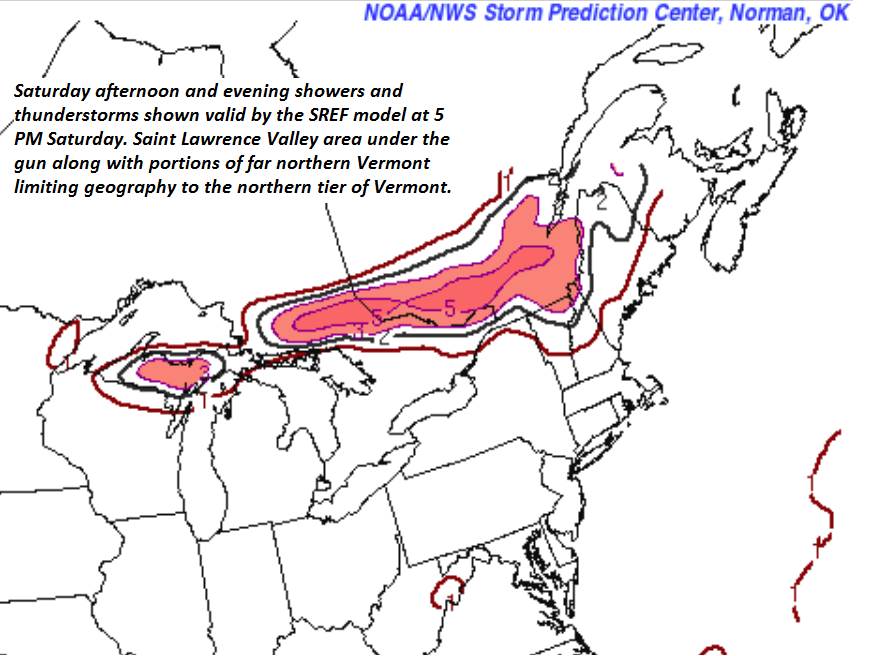
SATURDAY NIGHT: Partly cloudy & more humid. Scattered evening showers and thunderstorms across portions of northern Vermont, some locally strong & heavy. A low 60 to 65. Light southwest winds.

SUNDAY: Mixed sun and clouds with isolated afternoon showers & thunderstorms. A high around 85. West winds 10 mph.

Looking further ahead…

SUNDAY NIGHT: Scattered evening clouds, then clear with patchy valley fog. A low near 65

MONDAY: Mostly sunny. Hazy hot and sticky. A high around 90 with heat indices near 95.

TUESDAY: Lots of sunshine. Warm and muggy. A rising chance for late day showers and a few thunderstorms. A low 65 to 70. A high mid-80s to near 90.

WEDNESDAY: Mixed sun and clouds. Muggy. Chance for afternoon showers and thunderstorms, some locally strong & heavy. A low around 65. A high upper 70s northern areas, to mid-80s.

Average low 50 to 55. Average highs low to mid-70s.

Start of Meteorological Summer June 6th… Summer peaks approx.. July 22nd based off local climatology.

RH/6-4forecast][end]

Updated Friday Morning Forecast — June 4th, 2021

TODAY: Partly sunny and a bit humid, with a significant warming trend. Showers and isolated afternoon thunderstorms Rutland area south. A high mid to upper 70s. Light west to southwest winds.

TONIGHT: Partly cloudy to mostly clear. Patchy valley fog. A low in the mid to upper 50s. Light south to southwest winds.

SATURDAY: Morning sun mixing with more clouds. Warm, muggy and breezy at times. Isolated late day thunderstorms, some possibly strong. A high 80 to 85. Southwest breeze 10 to 20 mph.

Looking further ahead…

SATURDAY NIGHT: Variably cloudy & more humid. Widely scattered thunderstorms developing late evening on, some strong & locally heavy. A low 60 to 65.

SUNDAY: Mixed sun and clouds with widely scattered afternoon showers & thunderstorm. A high around 85.

MONDAY: Mostly sunny. Hazy hot and sultry. A low near 65. A high near 90.

TUESDAY: Lots of sunshine. Warm and muggy. Maybe a late day shower/storm. A low 65 to 70. A high mid to upper 80s.

WEDNESDAY: Mixed sun and clouds. Chance for a shower/storm southern areas. A low 60 to 65. Start of a cooling trend. A high 80 to 85.

Average low 50 to 55. Average highs low to mid-70s.

Start of Meteorological Summer June 6th… Summer peaks approx.. July 22nd based off local climatology.

RH/6-4forecast][end]

Updated Thursday Evening Forecast — June 3rd, 2021

TONIGHT: Mainly cloudy. A period of showers and a few thunderstorms…some locally heavy especially western and southern portions of Vermont, winding down overnight. Considerable areas of fog developing. A low 55 to 60. Light southwest winds.

TOMORROW: A few showers and isolated thunderstorms far southern areas. Otherwise, partly sunny warm and more muggy. A high mid to upper 70s. Light west to southwest winds.

FRIDAY NIGHT: Partly cloudy to mostly clear. Patchy valley fog. A low 55 to 60. Light south to southwest winds.

SATURDAY: Morning sun mixing with more clouds. Warm and muggy and breezy at times. Isolated late afternoon thunderstorms. A high 80 to 85. Southwest breeze 10 to 20 mph.

Looking further ahead…

SATURDAY NIGHT: Partly to mostly cloudy & humid. Widely scattered thunderstorms developing toward midnight, some locally heavy. A low 60 to 65.

SUNDAY: Lots of sunshine. A few afternoon clouds. Maybe an afternoon shower or thunderstorm. A high mid to upper 80s.

MONDAY: Mostly sunny. Hazy hot and sticky. A low near 65. A high around 90.

TUESDAY: Lots of sunshine. Warm and muggy. A low in the mid to upper 60s. A high mid to upper 80s.

WEDNESDAY: Mixed sun and clouds. Chance for a shower/storm southern areas. A low around 60. A high in the low to mid 80s.

Average low 50 to 55. Average highs low to mid-70s.

Start of Meteorological Summer June 6th… Summer peaks approx.. July 22nd based off local climatology.

RH/6-3forecast][end]

Updated Thursday Morning Forecast — June 3rd, 2021

TODAY: Lots of clouds & muggier. Scattered showers northern areas, becoming more frequent later this afternoon. A few thunderstorms, some locally heavy western and southern Vermont. A high 70 to 75. South winds 10 mph.

TONIGHT: Mainly cloudy. A period of showers and thunderstorms likely…some locally heavy, winding down overnight. A low upper 50s to around 60. Light southwest winds.

FRIDAY: Scattered showers, isolated thunderstorms, mainly southern areas in the morning. Otherwise becoming partly sunny warm and humid. A high mid to upper 70s. Light west winds.

Looking further ahead…

FRIDAY NIGHT: Partly cloudy to mostly clear. A low 55 to 60.

SATURDAY: Morning sun mixing with more clouds. Warm and muggy and breezy at times. Scattered thunderstorms…some possibly strong northern areas toward evening. A high in the lower 80s.

SUNDAY: Lots of sunshine. A few afternoon clouds with isolated afternoon thunderstorms. A low around 65. A high upper 80s to near 90.

MONDAY: Mostly sunny. Hazy hot and humid. A low near 65. A high in the low 90s

TUESDAY: Lots of sunshine. Not as humid. A high upper 80s to around 90.

Average low 50 to 55. Average highs low to mid-70s.

Start of Meteorological Summer June 6th… Summer peaks approx.. July 22nd based off local climatology.

RH/6-3forecast][end]

Updated Wednesday Evening Forecast — June 2nd, 2021

TONIGHT: Considerable cloudiness. A round of showers developing southern area, arriving around or after midnight. A low in the mid-50s. Light south winds.

TOMORROW: Mainly cloudy & slightly muggier. Scattered showers, with a risk for thunderstorms late. A high in the low 70s. South winds 10 mph.

THURSDAY NIGHT: Mainly cloudy. A period of showers and thunderstorms likely…some locally heavy, winding down overnight. A low around 60. Light southwest winds.

FRIDAY: Morning clouds. Scattered showers, isolated thunderstorms, mainly southern areas. Otherwise becoming partly sunny warm and humid. A high 75 to 80. Light west winds.

Looking further ahead…

FRIDAY NIGHT: Partly cloudy to mostly clear. A low 55 to 60.

SATURDAY: Morning sun mixing with more clouds. Warm and muggy. An isolated shower or thunderstorm far northern areas toward evening. A high in the low 80s.

SUNDAY: Lots of sunshine. A few afternoon clouds with isolated afternoon thunderstorms. A low around 65. A high 85 to 90.

MONDAY: Mostly sunny. Hazy hot and humid. A low near 65. A high around 90.

TUESDAY: Lots of sunshine. Not as humid. A high 85 to 90.

Average low 50 to 55. Average highs low to mid-70s.

Start of Meteorological Summer June 6th… Summer peaks approx.. July 22nd based off local climatology.

RH/6-2forecast][end]

Updated Wednesday morning Forecast — June 2nd, 2021

TODAY: Sunshine this morning, becoming filtered thru high clouds…thickening up this afternoon. Milder. A high in the mid to upper 70s. Southwest breeze 10 mph.

TONIGHT: Overcast. A round of showers developing around or after midnight. A low in the mid-50s. Light south winds.

THURSDAY: Mainly cloudy & slightly muggier. Scattered showers, with a risk for thunderstorms late. A high near 70. South winds 10 to 15 mph.

Looking further ahead…

THURSDAY NIGHT: Mainly cloudy. A period of showers and thunderstorms likely…some locally heavy, winding down overnight. A low around 60.

FRIDAY: Morning clouds with scattered showers and isolated thunderstorms, mainly southern areas. Otherwise becoming mostly sunny warm and humid. A high mid to upper 70s.

SATURDAY: Morning sun with a few afternoon clouds. Warm and muggy. An isolated shower or thunderstorm far northern areas toward evening. A low 55 to 60. A high in the low 80s.

SUNDAY: Mixed sun and clouds. Isolated afternoon thunderstorms. A low around 65. A high 85 to 90.

MONDAY: Partly to mostly sunny. Hazy hot and humid. A low near 65. A high around 90.

Average low 50 to 55. Average highs low to mid-70s.

Start of Meteorological Summer June 6th… Summer peaks approx.. July 22nd based off local climatology.

RH/6-2forecast][end]

Updated Tuesday Evening Forecast — June 1st, 2021

TONIGHT: Clear skies with some high clouds toward morning. Patchy dense valley fog. A low in the mid-40s. Light southwest winds.

TOMORROW: Filtered sun thru high clouds…thickening up in the afternoon. Milder. A high in the mid to upper 70s. Southwest breeze 10 mph.

WEDNESDAY NIGHT: Mostly cloudy. A round of showers likely…after midnight. A low around 55. Light south winds.

THURSDAY: Mainly cloudy & slightly muggier. Good chance for showers, maybe an isolated rumble of thunder late. A high around 70. South winds 10 to 15 mph.

Looking further ahead…

THURSDAY NIGHT: Cloudy. A chance for evening showers and thunderstorms. A low 55 to 60.

FRIDAY: Morning clouds with scattered showers and thunderstorms, giving way to increasing afternoon sun. Moderately warm and bit more humid. Maybe a late day thunderstorm. A high around 75.

SATURDAY: Partly sunny warm and muggy. Maybe a late day and evening shower or thunderstorm. A low 55 to 60. A high around 80.

SUNDAY: Mixed sun and clouds. Slight chance for an afternoon shower or thunderstorm. A low 60 to 65. A high around 85.

MONDAY: Lots of sunshine. Hazy hot and humid. A low near 65. A high around 90.

Average low 50 to 55. Average highs low to mid-70s.

Start of Meteorological Summer June 6th… Summer peaks approx.. July 22nd based off local climatology.

RH/6-1forecast][end]

Updated Tuesday Morning Forecast — June 1st, 2021

TODAY: Morning fog & low clouds gives way to afternoon sunshine. A few isolated showers possible but milder this afternoon A high in the upper 60s to around 70. Light southwest winds.

TONIGHT: Clear skies with some high clouds toward morning. Patchy dense valley fog. A low in the mid-40s. Light southwest winds.

WEDNESDAY: Filtered sun thru high clouds…thickening up in the afternoon. Milder. A high in the mid to upper 70s. Southwest breeze 10 mph.

Looking further ahead…

WEDNESDAY NIGHT: Mostly cloudy. Rising chance for showers. A low around 55.

THURSDAY: Mainly cloudy & muggier. Chance for showers, maybe an isolated rumble of thunder in the afternoon into Thursday night. A high 70 to 75.

FRIDAY: Morning clouds. Scattered morning showers and thunderstorms, gives way to partial afternoon sun, warm and humid. Chance for late day thunderstorms. A low around 60. A high in the 70s.

SATURDAY: Partly sunny warm and muggy. Maybe a late day and evening shower or thunderstorm. A low 55 to 60. A high around 80.

SUNDAY: Mixed sun and clouds. Slight chance for an afternoon shower or thunderstorm. A low 60 to 65. A high around 85.

MONDAY: Hazy warm and humid A low near 65. A high mid-80s to near 90.

Average low 50 to 55. Average highs low to mid-70s.

Start of Meteorological Summer June 6th… Summer peaks approx.. July 22nd based off local climatology.

RH/6-1forecast][end]

Updated Monday Morning Forecast — May 31st Memorial Day, 2021

TODAY: Scattered pockets of drizzle and light showers along and east of the Green Mountains…otherwise remaining cloudy, damp and cool with areas of morning fog. A high in the mid-50s. Light north to northwest winds.

TONIGHT: A few lingering showers this evening eastern areas, otherwise lots of clouds. Patchy valley fog. A low 40 to 45. Light south winds.

TUESDAY: Morning fog and low clouds, then periods of afternoon sun. A high in the upper 60s to low 70s. Southwest breeze 10 mph.

Looking further ahead…

TUESDAY NIGHT: Mostly clear. Patchy dense valley fog. A low in the mid to upper 40s.

WEDNESDAY: Filtered sunshine thru high clouds…thickening up in the afternoon. Milder. A high in the mid-70s.

THURSDAY: Overcast. Chance for showers, with a risk of few rumbles of thunder. A low 55 to 60. Muggier. A high 70 to 75.

FRIDAY: Mostly cloudy, warm and humid. Scattered showers & mainly afternoon thunderstorms. A low near 60. A high 75 to 80.

SATURDAY: Partly sunny warm and muggy. Scattered showers and thunderstorms. A low around 60. A high 80 to 85.

Average low upper 40s to low 50s. Average highs upper 60s to mid-70s.

Start of Meteorological Summer June 6th… Summer peaks approx.. July 22nd based off local climatology.

RH/5-31forecast][end]

Updated Friday Evening Forecast — May 28th, 2021

TONIGHT:Cloudy. Showers likely southern portions. A low ranging 35 to 40.Light northeast winds.

TOMORROW: Morning showers southern areas exits, otherwise clouds in the morning, giving way to periods of afternoon sun. Still rather chilly. A high upper 50s to near 60. Light northeast winds.

SATURDAY NIGHT: Mostly clear northern areas in the evening giving way to more clouds overnight. Isolated areas of fog. A low in the mid-30s, with pockets of frost possible northern areas. Light east winds.

SUNDAY: Considerable cloudiness. Occasional light showers southern areas late morning reaching the Quebec border late. Dry parts of the Champlain Valley. Very chilly. A high in the low to mid 50s. Light east winds.

Looking further ahead…

SUNDAY NIGHT: Cloudy. Considerable valley fog. Scattered showers or sprinkles.

MONDAY MEMORIAL DAY: Mainly cloudy. Milder trend. A low around 45. Warmer. A high mid-60s.

TUESDAY: Morning fog and low clouds, then intervals of sun. A low around 45. A high in the lower 70s.

WEDNESDAY: More sun than clouds. A low around 45. A high in the mid-70s.

Average low upper 40s to low 50s. Average highs upper 60s to mid-70s.

Start of Meteorological Summer June 6th… Summer peaks approx.. July 22nd based off local climatology.

RH/5-28forecast][end]