Updated Wednesday Evening Forecast — April 12th, 2017

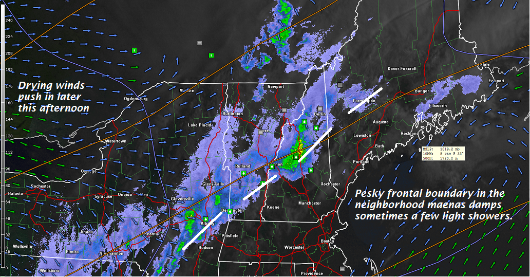
TONIGHT: Partly cloudy this evening, then more clouds with a few rain showers mixing with wet snow flakes higher northern mountains. A low in the mid 30s. Light west winds.

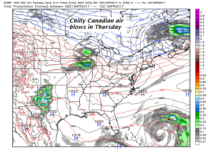
TOMORROW: Maybe a morning sprinkle mixed with a few wet snow flakes. Otherwise lots of clouds giving way to intervals of late afternoon sunshine. A high pushing toward 50. Northwest winds 10 to 25 mph.

THURSDAY NIGHT: Mostly clear and partially moonlit. A low in the upper 20s to near 30. Little wind.

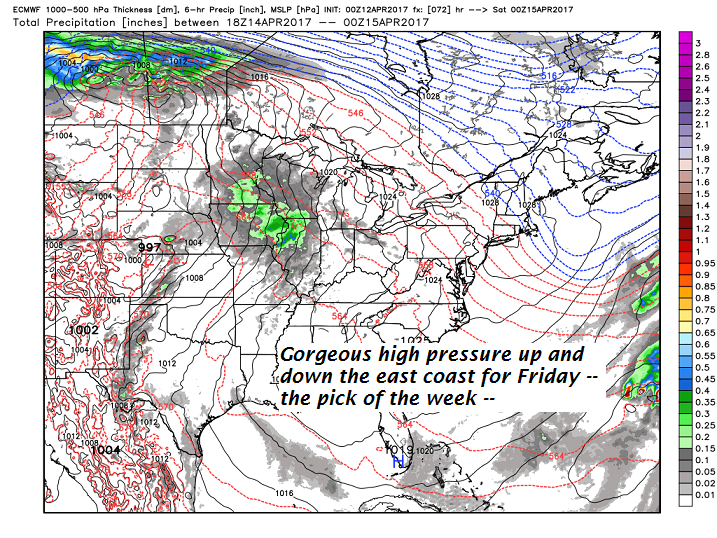
FRIDAY: Pick of the week. Blue skies and bright sunshine. A high near 55. Northwest winds 10 to 15 mph.

Looking Further ahead…

FRIDAY NIGHT: Clear early then increasing high cloudiness. A low near 32.

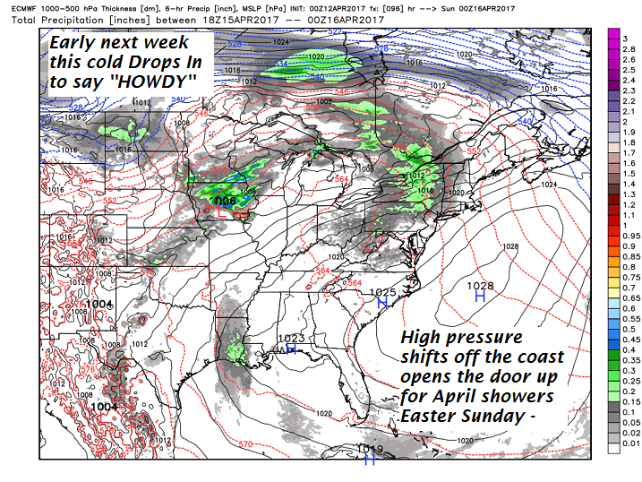
SATURDAY: Filtered morning sunshine early, then clouding up with a rising chance for rain or showers last half of the afternoon. A high in the low to mid 60s.

EASTER SUNDAY: Clouds with a few hints of sunshine. “April showers” off and on were likely. A low 45 to 50. A high in the mid 60s.

MONDAY: Scattered morning sprinkles mixed with a wet snow flakes, otherwise partly to mostly cloudy. Much cooler. Temperatures holding in the low to mid 40s.

TUESDAY: Mixed sun and clouds. A low in the 20s. A high in the mid 40s.

Average lows around 32. Normal highs in the low to mid 50s

RH/4-12[end]

Updated Wednesday morning forecast — April 12th, 2017

TODAY: Clouds and areas of morning fog with occasional rain showers this morning Barre-Montpelier area and points south. Partial sunshine this afternoon with a high in the upper 50s. West winds picking up to 10 to 15 mph.

TONIGHT: Clear skies in the evening then clouding up overnight. A few rain showers mixing with wet snow flakes higher northern mountains. A low in the mid 30s. Light west winds.

THURSDAY: Maybe a morning sprinkle. Otherwise lots of clouds giving way to intervals of late afternoon sunshine. A high pushing toward 50. Northwest winds 10 to 20 mph.

Looking Further ahead…

THURSDAY NIGHT: Mostly clear and partially moonlit. A low in the upper 20s to near 30.

FRIDAY: Pick of the week. Blue skies and bright sunshine. A high near 55.

SATURDAY: Filtered sunshine through high cloudiness thickening up late leading to a chance for showers Saturday evening. A low near 32. A high in the low to mid 60s

SUNDAY: Cloudy and gray. Chance for “April showers”. A low 45 to 50. A high in the mid 60s.

MONDAY: Much cooler. Scattered rain showers mixed with wet snow flakes in the hills in the morning. Temperatures holding in the low to mid 40s.

TUESDAY: Partly to mostly cloudy and A low in the 20s. A high in the mid 40s .

Average lows around 32. Normal highs in the low to mid 50s

RH/4-12[end]

Updated Tuesday Evening forecast — April 11th, 2017

TONIGHT: Scattered evening showers. Chance for a few thunderstorms south of the Barre Montpelier area this evening, Otherwise mostly cloudy and still mild. A low in the 40s. Light south winds.

TOMORROW: Clouds with a couple rain showers through mid day then exiting to partly to mostly sunny skies. A high in the upper 50s to low 60s. West winds picking up to 10 to 15 mph.

WEDNESDAY NIGHT: Clear skies in the eve4ning then clouding up overnight. A few rain showers mixing with wet snow flakes higher northern mountains. A low 35 to 40. Light west winds.

THURSDAY: Chance for a morning sprinkle northern areas. Otherwise clouds giving way to intervals of late afternoon sunshine. A high in the upper 40s. Northwest winds 10 to 20 mph.

Looking Further ahead…

THURSDAY NIGHT: Mostly clear and moonlit. A low 25 to 30.

FRIDAY: Pick of the week. Blue skies and bright sunshine. A high in the mid 50s.

SATURDAY: Filtered sunshine through high cloudiness. A low 32 to 35 A high in the upper 50s to mid 60s

SUNDAY: Lots of clouds with “April showers”. A low in the 50s. A high in the upper 50s to mid 60s.

Average lows around 32. Normal highs in the low to mid 50s

RH/4-11[end]

Updated Tuesday morning forecast — April 11th, 2017

TODAY: Chance for a brief shower far northern areas this morning, otherwise partial sunshine giving way to more clouds in the afternoon. Widely scattered showers and thunderstorms after to 4 PM. Warm with a high in the mid 70s. West to southwest winds 10 mph.

TONIGHT: Scattered evening showers with a chance for a few thunderstorms possible southern areas. Otherwise mostly cloudy and still mild. A low 45 to 50. Light south winds.

WEDNESDAY: Mostly cloudy. Chance for rain showers exiting later in the day. A high in the low 60s. West winds picking up to 10 to 20 mph.

Looking Further ahead…

WEDNESDAY NIGHT: Fair early then mostly cloudy. A few rain showers mixing with wet snow mainly northern mountains. A low in the mid 30s.

THURSDAY: Chance for a morning sprinkle northern areas. Otherwise clouds giving way to intervals of late afternoon sunshine. A high in the upper 40s.

FRIDAY: Pick of the week. Blue skies and bright sunshine. A low in the mid to upper 20s. A high in the mid 50s.

SATURDAY: Filtered sunshine through high cloudiness. A low near 30. A high in the mid 50s to near 60

Average lows around 32. Normal highs in the low to mid 50s

RH/4-11[end]

Updated Monday Evening forecast — April 10th, 2017

Full “Pink Moon” 2:09 AM

TONIGHT: Partially moonlit skies. Threat of a shower or two near the Quebec border. A low in the 40s. Light southwest winds.

TOMORROW: Partial morning sun, then mostly cloudy later in the afternoon. Widely scattered showers and thunderstorms after 3 PM. Warm with a high 70 to 75. West to southwest winds 10 mph.

TUESDAY NIGHT: Scattered evening showers with a few thunderstorms possible southern areas. Otherwise mostly cloudy and still mild. A low 45 to 50. Light south winds.

WEDNESDAY: Mostly cloudy. Chance for rain showers exiting later in the day. A high around 60. West winds picking up to 10 to 20 mph.

Looking Further ahead…

WEDNESDAY NIGHT: Fair early then mostly cloudy. A few rain showers mixing with wet snow mainly northern mountains. A low in the low to mid 30s.

THURSDAY: Chance for a morning sprinkle northern areas. Otherwise clouds giving way to intervals of late afternoon sunshine. A high near 50.

FRIDAY: Pick of the week. Blue skies and bright sunshine. A low around 32. A high in the 50s.

SATURDAY: Filtered sunshine through high cloudiness. A low near 30. A high in the low 60s.

Average lows around 32. Normal highs in the low to mid 50s

RH/4-10[end]

Updated Monday morning forecast — April 10th, 2017

TODAY: Partly to mostly sunny with variable high clouds. Well above normal in temperature. A high in the low 70s. South to southwest breeze 10 to 15 mph.

Full “Pink Moon” 2:09 AM

TONIGHT: Partially to fully moonlit skies. Slight chance for a sprinkle far northern areas. A low around 40. Light southwest winds.

TUESDAY: Partial morning sun then mostly cloudy later in the afternoon with a chance showers a possible thunderstorms. Warm with a high 70 to 75. Light west to southwest winds.

Looking Further ahead…

TUESDAY NIGHT: Chance for an evening shower or thundershower. Otherwise mostly cloudy and still mild. A low 45 to 50.

WEDNESDAY: Mostly cloudy. Chance for rain showers exiting later in the day. A high 55 to 60.

THURSDAY: Chance for a morning sprinkle northern areas. A low in the 30s. A high in the low 50s.

FRIDAY: Blue skies and bright sunshine. A low around 32. A high in the in the upper 40s to around 50.

SATURDAY: Filtered sunshine through high cloudiness. A low near 32. A high in the low to mid 60s.

Average lows in the around 30. Normal highs in the low to mid 50s

RH/4-10[end]

Updated Friday evening Forecast — April 7th, 2017

TONIGHT: Lots of clouds.. Scattered rain showers mixing with or changing to wet snow showers. A dusting to 2 inches in the higher terrain. A low in the upper 20s. Northwest winds picking up 10 to 20 mph.

TOMORROW: Morning snow showers winding down to scattered flurries with a dusting to a couple additional inches in the higher terrain. An interval of afternoon sunshine away from the mountains. Blustery. A high around 35. Northwest winds 10 to 25 mph.

SATURDAY NIGHT: Evening cloudiness exits to clearing skies. A low 15 to 20. Light west winds.

SUNDAY: Lots of sunshine with a some high cloudiness, a beauty. A high in the low to mid 50s. Light southwest winds.

Looking Further ahead…

SUNDAY NIGHT: Variable clouds. A low around 40.

MONDAY: Partly sunny. Maybe a sprinkle far northern areas. A high in the low 70s.

TUESDAY: Variable mixed clouds and sun. Chance for rain showers in the afternoon. A low in the upper 30s to mid 40s. A high upper 60s to mid 70s.

WEDNESDAY: Mostly cloudy. Chance for rain showers. A low 35 to 40 with a high 55 to 60.

Average lows in the upper 20s to around 30. Normal highs in the low to mid 50s

RH/4-7[end]

Updated Friday morning Forecast — April 7th, 2017

TODAY: Scattered rain showers or sprinkles mixing with wet snow flakes in the higher terrain. Maybe an interval of afternoon sunshine. A high 40 to 45. Light southwest winds.

TONIGHT: Lots of clouds.. Scattered rain showers mixing with wet snow across the elevated terrain. A low in the upper 20s to low 30s. Northwest winds 10 to 20 mph.

SATURDAY: Morning snow showers winding down to scattered flurries with a dusting to 2” possible in the hills. An interval of afternoon sunshine away from the mountains. Blustery. .A high around 35. Northwest winds 10 to 25 mph.

Looking Further ahead…

SATURDAY NIGHT: Evening cloudiness exits to clearing skies. A low around 20.

SUNDAY: Lots of sunshine with a some high cloudiness, a beauty. A high in the mid 50s.

MONDAY: Partly sunny. Maybe a sprinkle far northern areas. A low 35 to 40. A high near 70.

TUESDAY: Variable mixed clouds and sun. Chance for rain showers in the afternoon. A low in the upper 30s to mid 40s. A high in the low 70s.

WEDNESDAY: Mostly cloudy. Chance for rain showers. A low in the 40s with a high in the 50s.

Average lows in the upper 20s to around 30. Normal highs in the upper 40s to low 50s

RH/4-7[end]

Updated Thursday Evening forecast — April 6th, 2017

Flood Watch in effect Thursday through Saturday…due to combined snow melt and rainfall

TONIGHT: Showers gradually tapering to sprinkles overnight. Areas of fog. A low in the mid to upper 30s. Southeast winds 10 to 15 mph but stronger along western slopes of Greens.

TOMORROW: Scattered light rain showers or sprinkles. Maybe an interval of afternoon sunshine. A high 40 to 45. Light southwest winds.

FRIDAY NIGHT: Mostly cloudy. Scattered rain showers mixing with wet snow across the elevated terrain. A low around 30. Northwest winds 10 to 20 mph.

SATURDAY: Morning snow showers winding down to scattered flurries with a dusting to 2” possible. Otherwise a few intervals of afternoon sunshine developing. A high in the mid 30s. Northwest winds 10 to 25 mph.

Looking Further ahead…

SATURDAY NIGHT: Evening clouds then clearing. A low 20 to 25.

SUNDAY: Lots of sunshine with a some high cloudiness, gorgeous and spring-like temperatures. A high 55 to 60

MONDAY: Sunshine mixed with variable high cloudiness. A low in the upper 30s. A high in the low 70s.

TUESDAY: Variable Mixed clouds and sun. Chance for a showers late. A low 45 to 50. A high in the low 70s.

WEDNESDAY: Mostly cloudy. with scattered rain showers far northern areas. A low in the 40s with a high 55 to 60.

Average lows in the upper 20s to around 30. Normal highs in the upper 40s to low 50s

RH/4-6[end]

Updated Thursday morning Forecast — April 6th, 2017

Flood Watch in effect Thursday through Saturday…due to combined snow melt and rainfall

TODAY: Gray skies. Intermittent light rain developing this morning, Rain this afternoon possibly moderate at times with a high near 40. Areas of fog. Southeast winds 10 to 20 mph much strong along western slopes of the Greens.

TONIGHT: Showers gradually tapering to sprinkles overnight. Areas of fog. A low 35 to 40. Southeast winds 10 to 15 mph but stronger along western slopes of Greens.

FRIDAY: Scattered light rain showers or sprinkles. Maybe an interval of afternoon sunshine. A high near 45. Light southwest winds.

Looking Further ahead…

FRIDAY NIGHT: Mostly cloudy. Scattered rain showers mixing with wet snow across the elevated terrain. A low around 30.

SATURDAY: Morning snow showers winding down to scattered flurries with a dusting to 2” possible. Otherwise a few intervals of afternoon sunshine developing. A high in the mid 30s to around 40.

SUNDAY: Mostly sunny with a few high clouds, gorgeous and spring-like temperatures. A low 20 to 25. A high near 55.

MONDAY: Sunshine mixed with variable high cloudiness. A low in the mid 30s. A high near 70.

TUESDAY: Partly sunny and warm. A low 45 to 50. A high in the 70s.

WEDNESDAY: Mostly cloudy with scattered rain showers far northern areas. A low in the 40s with a high 55 to 60.

Average lows in the upper 20s to around 30. Normal highs in the upper 40s to low 50s

RH/4-5[end]