
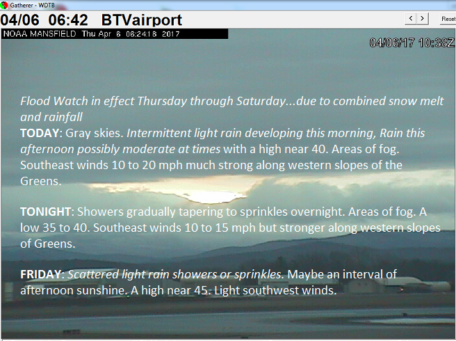
Flood Watch in effect Thursday through Saturday…due to combined snow melt and rainfall
TODAY: Gray skies. Intermittent light rain developing this morning, Rain this afternoon possibly moderate at times with a high near 40. Areas of fog. Southeast winds 10 to 20 mph much strong along western slopes of the Greens.
TONIGHT: Showers gradually tapering to sprinkles overnight. Areas of fog. A low 35 to 40. Southeast winds 10 to 15 mph but stronger along western slopes of Greens.
FRIDAY: Scattered light rain showers or sprinkles. Maybe an interval of afternoon sunshine. A high near 45. Light southwest winds.
Looking Further ahead…
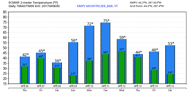
FRIDAY NIGHT: Mostly cloudy. Scattered rain showers mixing with wet snow across the elevated terrain. A low around 30.
SATURDAY: Morning snow showers winding down to scattered flurries with a dusting to 2” possible. Otherwise a few intervals of afternoon sunshine developing. A high in the mid 30s to around 40.
SUNDAY: Mostly sunny with a few high clouds, gorgeous and spring-like temperatures. A low 20 to 25. A high near 55.
MONDAY: Sunshine mixed with variable high cloudiness. A low in the mid 30s. A high near 70.
TUESDAY: Partly sunny and warm. A low 45 to 50. A high in the 70s.
WEDNESDAY: Mostly cloudy with scattered rain showers far northern areas. A low in the 40s with a high 55 to 60.
Average lows in the upper 20s to around 30. Normal highs in the upper 40s to low 50s
RH/4-5[end]
