Updated Wednesday Evening Forecast — January 27th, 2021

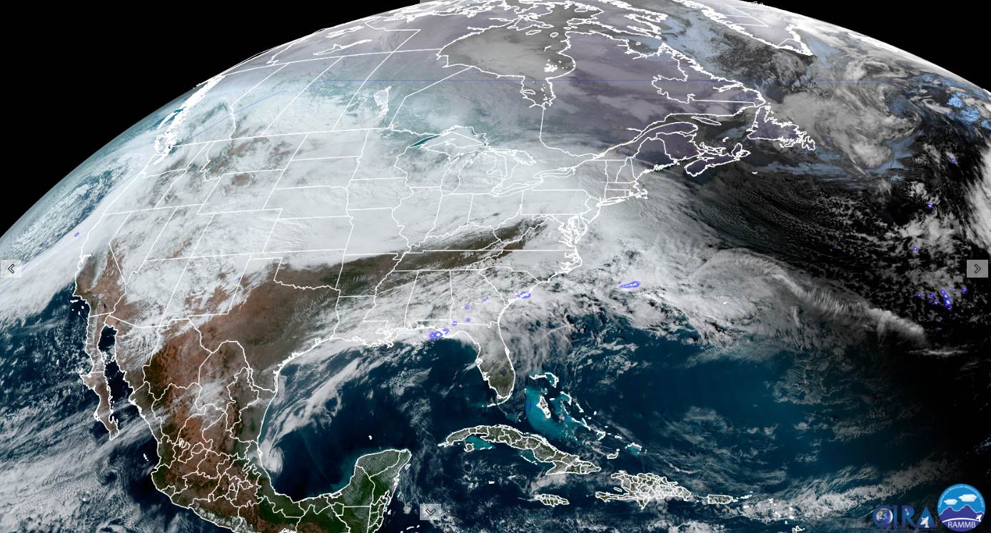
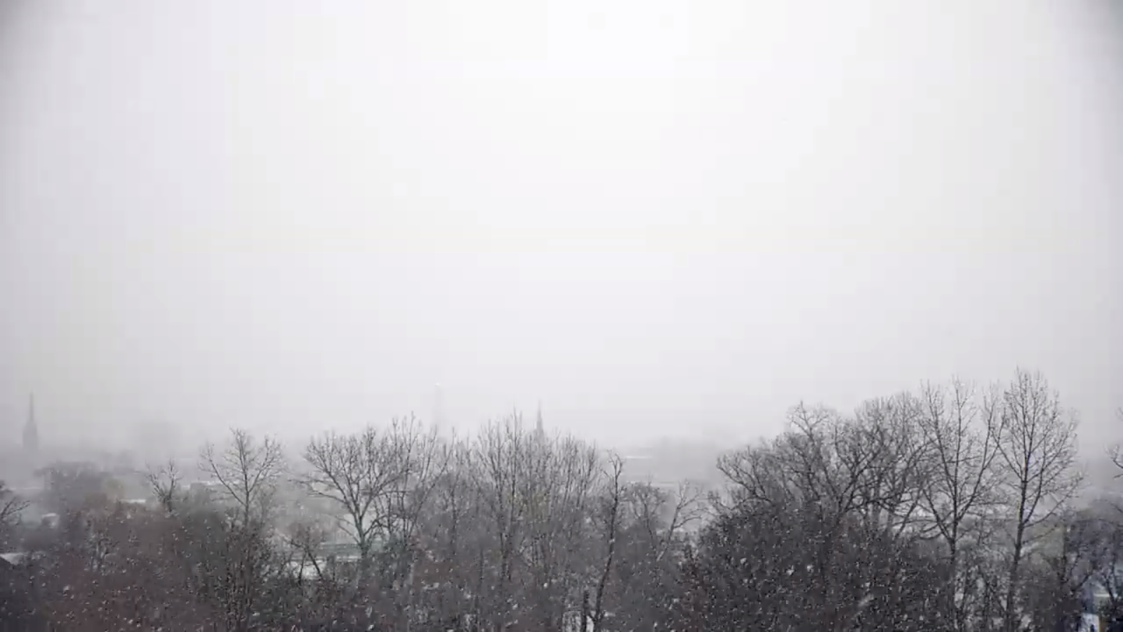
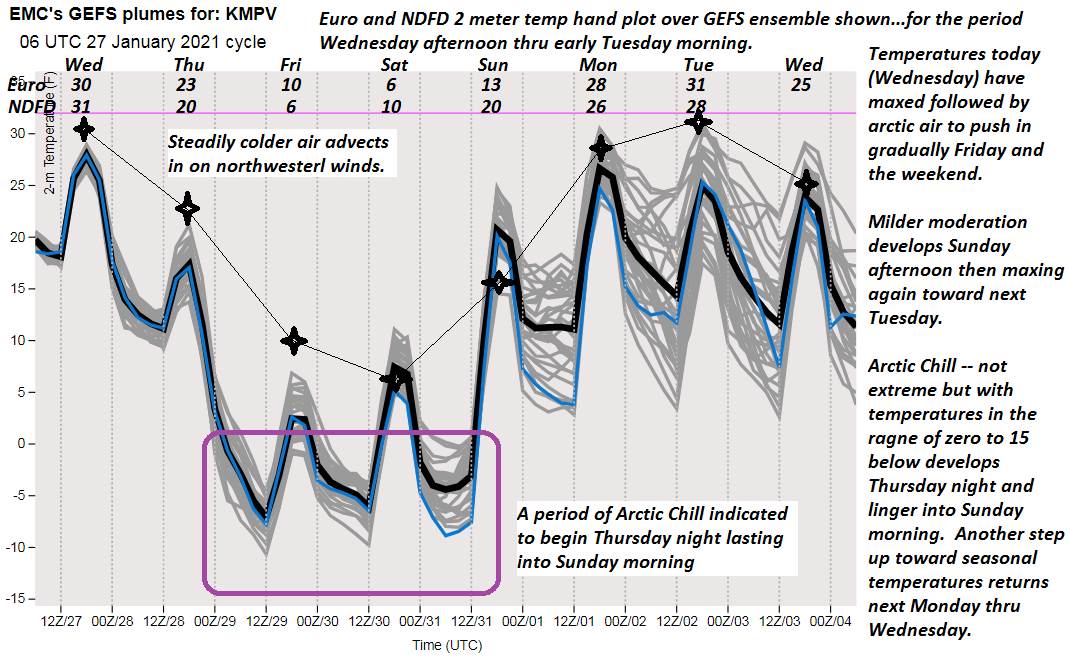
TONIGHT: Cloudy. Occasional flurries with a light fluffy coating. A low mid to upper teens. Light northwest winds.

Full Wolf Moon 2:16 PM Thursday

TOMORROW: Clouds with an occasional flurry & turning colder a bit blustery. Scattered flurries with a fluffy dusting. Temperatures falling through the teens. Northwest winds 10 mph.

THURSDAY NIGHT: Clouds…give to partial clearing overnight. Frigid. “Diamond dust flurries.” A low 5 below to 5 above. Northwest winds 10 mph lowering wind chills.

FRIDAY: Clouds give way periods of sun in the afternoon. Blustery at times & bitterly cold. “Diamond dust flurries.” A high about 5 to 10 above. Northwest winds 10 mph lowering wind chills.

Looking further ahead…

FRIDAY NIGHT: Scattered clouds with “diamond dust flurries.” A low 5 to 15 below zero. Lowered wind chills.

SATURDAY: Morning clouds, then arctic-like sunshine. “Diamond dust flurries.” Bitterly cold. A high about 5 to 10 above.

SUNDAY: Arctic-like sunshine. Frigid. A low zero to 15 below. A high 10 to 15.

MONDAY: Mostly sunny. A low 10 below cold spots…to 5 above. A high mid to upper 20s.

TUESDAY: A few more clouds but lots of sunshine. A low around 10 to 15 above. A high pushing toward 30.

Average low ranging thru the single digits to low teens, Average highs mid-20s to low 30s

Peak of Winter End of Winter March 9th… based off local climatology.

RH/1-26 category forecast][end]

Updated Wednesday Morning Forecast — January 27th, 2021

TODAY: Morning flurries or light snow showers becoming isolated confined to the mountains this morning. A dusting or so. Otherwise, lots of clouds but little milder. A high near 32. Wind becoming light and northwesterly.

TONIGHT: Cloudy. Occasional flurries and light snow showers with a light fluffy coating. A low mid to upper teens. Light northwest winds.

Full Wolf Moon 2:16 PM Thursday

THURSDAY: Clouds with a few breaks of sun southern and eastern areas. Scattered flurries. A high 20 to 25. Northwest winds 10 mph.

Looking further ahead…

THURSDAY NIGHT: Clouds…give to partial clearing overnight. Frigid. “Diamond dust flurries.” A low 5 below to 5 above.

FRIDAY: Mostly cloudy, blustery at times & bitterly cold. “Diamond dust flurries.” A high upper single digits to about 10 above.

SATURDAY: Morning clouds, then arctic-like sunshine. “Diamond dust flurries.” Bitterly cold. A low ranging zero to 15 below. A high about 5 to 10 above.

SUNDAY: Arctic-like sunshine. Frigid. A low zero to 15 below. A high 10 to 15.

MONDAY: Mostly sunny. A low 10 below cold spots…to 5 above. A high mid to upper 20s.

TUESDAY: A few more clouds but lots of sunshine. A low around 10 to 15 above. A high pushing toward 30.

Average low ranging thru the single digits to low teens, Average highs mid-20s to low 30s

Peak of Winter End of Winter March 9th… based off local climatology.

RH/1-26 category forecast][end]

Updated Tuesday Evening Forecast — January 26th, 2021

Winter Weather Advisory S. 4 counties thru Wednesday late morning…

TONIGHT: Overcast. Light accumulating snow arrives early this evening. 1 to 2” northern areas…2 to locally 5” especially southern Green Mountains. A low near 20. Light east to southwest winds.

TOMORROW: Morning flurries or light snow showers becoming isolated confined to the mountains with a little more than a dusting. Otherwise, lots of clouds. A high in the low 30s. Wind becoming light and northwesterly.

WEDNESDAY NIGHT: Cloudy. Occasional flurries and light snow showers with a light fluffy coating. A low 10 to 15. Light northwest winds.

Full Wolf Moon 2:16 PM Thursday

THURSDAY: Considerable cloudiness. Scattered flurries. A high 20 to 25. Northwest winds 10 mph.

Looking further ahead…

THURSDAY NIGHT: Clouds…give to partial clearing overnight. Frigid. “Diamond dust flurries.” A low 5 below to 5 above.

FRIDAY: More clouds than sun, blustery at times & colder. “Diamond dust flurries.” A high only near 10 above.

SATURDAY: Arctic-like sunshine. “Diamond dust flurries.” Bitterly cold. A low ranging 5 to 15 below. A high about 5 to 10 above.

SUNDAY: Arctic-like sunshine. A low 5 to 15 below. A high mid to upper teens.

Average low ranging thru the single digits to low teens, Average highs mid-20s to low 30s

Peak of Winter End of Winter March 9th… based off local climatology.

RH/1-26 category forecast][end]

Updated Tuesday Morning Weather — January 26th, 2021

TODAY: Clouds and sun, gives way to thickening clouds later this afternoon. Light accumulating snow develops southern areas late. A high in the upper 20s to near 30. Light southeast winds.

Winter Weather Advisory S. 4 counties of Vermont late Tuesday into Wednesday morning…

TONIGHT: Overcast. Light accumulating snow arrives early this evening. Dusting to 2” northern areas…2 to locally 5” especially southern Green Mountains. A low near 20. Light east winds.

WEDNESDAY: Morning flurries or light snow showers becoming isolated for a time. More snow showers or flurries flare-up later in the afternoon with a dusting to an inch. Otherwise lots of clouds. A high near 32. Light northwest winds.

Looking further ahead…

WEDNESDAY NIGHT: Occasional flurries and light snow showers. A low in the teens.

Full Wolf Moon 2:16 PM Thursday

THURSDAY: Considerable cloudiness. Scattered mountain flurries. Blustery at times. A high near 25.

FRIDAY: More clouds than sun, blustery and cold. “Diamond dust flurries.” A low 5 below to 5 above. A high only around 10 above.

SATURDAY: Partly sunny. “Diamond dust flurries.” Frigid. A low zero to 10 below. A high in the upper around 10 above.

SUNDAY: Arctic-like sunshine. A low 5 to 15 below. A high 10 to 15.

Average low ranging thru the single digits to low teens, Average highs mid-20s to low 30s

Peak of Winter End of Winter March 9th… based off local climatology.

RH/1-26 category forecast][end]

Updated Monday Evening Forecast — January 25th, 2021

TONIGHT: Variable cloudiness. A few flurries across northern areas. A low ranging thru the single digits above. Little wind.

TOMORROW: Filtered morning sun, gives way to thickening clouds. Light accumulating snow develops southern areas late. A high mid to upper 20s. Light southeast winds.

Winter Weather Advisory S. 4 counties of Vermont late Tuesday into Wednesday morning…

TUESDAY NIGHT: Overcast. Periods of light accumulating snow or snow showers. Dusting to 2” northern areas…2 to locally 5” southern half of the state. A low around 20. Light east winds.

WEDNESDAY: Morning flurries becoming isolated. Otherwise lots of clouds. A high upper 20s to about 30. Light northwest winds.

Looking further ahead…

WEDNESDAY NIGHT: Scattered flurries. A dusting in spots. A low zero to 10 above.

Full Wolf Moon 2:16 PM Thursday

THURSDAY: Considerable cloudiness. A few mountain flurries. Blustery at times. A high near 25.

FRIDAY: More clouds than sun, blustery and cold. “Diamond dust flurries.” A low 5 below to 5 above. A high only around 10 degrees.

SATURDAY: Partly sunny. “Diamond dust flurries.” Frigid. A low zero to 10 below. A high in the mid-teens.

SUNDAY: Arctic-like sunshine. A low zero to 10 below. A high 10 to 15.

Average low ranging thru the single digits to low teens, Average highs mid-20s to low 30s

Peak of Winter End of Winter March 9th… based off local climatology.

RH/1-25 category forecast][end]

Updated Monday Morning Forecast — January 25th, 2021

TODAY: Gorgeous winter day. Bright sunshine & blue skies gives way to high cloudiness. A high around 20. Light northwest winds.

TONIGHT: Some cloudiness otherwise fair. More clouds near the Quebec border with a few flurries possible. Frigid. A low 5 below to 5 above. Little wind.

TUESDAY: Filtered sunshine early, then thickening clouds. A rising chance for light accumulating snow southern areas later in the afternoon. A high in the mid to upper 20s. Little wind.

Looking further ahead…

TUESDAY NIGHT: Overcast. Periods of light accumulating snow or snow showers. Dusting to 2” northern areas…2 to locally 5” southern parts of Vermont. A low upper teens to around 20.

WEDNESDAY: Scattered leftover morning flurries exiting. Otherwise lots of clouds. A high near 30.

Full Wolf Moon 2:16 PM Thursday

THURSDAY: Considerable cloudiness. A few mountain flurries. Blustery at times. A low 5 to 15. A high 20 to 25.

FRIDAY: More clouds than sun & blustery and cold. “Diamond dust flurries” & blustery. A low 5 below to 5 above. A high 10 to 15.

SATURDAY: Partly sunny. “Diamond dust flurries” A low zero to 10 below. A high in the mid-teens.

SUNDAY: Arctic-like sunshine. A low zero to 10 below. A high 10 to 15.

Average low ranging thru the single digits to low teens, Average highs mid-20s to low 30s

Peak of Winter End of Winter March 9th… based off local climatology.

RH/1-25 category forecast][end]

Updated Wednesday Evening Forecast — January 20th, 2021

I will be taking Thursday & Friday off and will be back to update this web page as well as repair a few things.

TONIGHT: Widely scattered northern mountain flurries this evening. Otherwise, partly cloudy. A low ranging 5 below to 5 above. Little wind.

TOMORROW: Gray. A period of light snow or snow showers mid to late morning on tapering to flurries in the afternoon. A dusting to 2”. A high 20 to 25. Light southeast winds.

THURSDAY NIGHT: Mostly cloudy. Accumulating snow showers and flurries. Dusting to an inch or two northern areas. A low around 20. Light south winds.

FRIDAY: Overcast, but a bit milder. Chance for nuisance flurries. Minor accumulations mainly far northern areas. A high around 32. Light west winds.

Looking further ahead…

FRIDAY NIGHT: Mostly cloudy. Chance for mountain snow showers and valley flurries. Minor accumulation. A low 10 to 15.

SATURDAY: Gray. Scattered mountain flurries. A high around 15.

SUNDAY: Morning clouds exiting to partly to mostly sunny. A bit blustery and colder. A low 5 below to 5 above. A high around 15 above.

MONDAY: Variable clouds northern areas, otherwise mostly sunny. A low 5 above to 10 below. A high in the mid-teens.

TUESDAY: Lots of clouds. Chance for light accumulating snow. A low 5 to 15 above. A high in the mid-20s.

Average low ranging thru the single digits to low teens, Average highs in the 20s.

Peak of Winter End of Winter March 9th… based off local climatology.

RH/1-20 category forecast][end]

Updated Wednesday Morning Forecast — January 20th, 2021

TODAY: Frequent accumulating snow showers winding down as flurries late morning on. Additional accumulations around an inch or two Barre-Montpelier area north. Turning blustery at times. A high 20 to 25. Northwest winds 10 mph.

TONIGHT: Widely scattered northern mountain flurries this evening. Otherwise, partly cloudy. A low ranging 5 below to 5 above. Little wind.

THURSDAY: Gray. Flurries or light snow showers developing mid to late morning on. A dusting to a couple inches. A high in the low to mid 20s. Light south winds.

Looking further ahead…

THURSDAY NIGHT: Mostly cloudy. Accumulating snow showers and flurries. Dusting to a couple inches especially northern areas. A low 15 to 20.

FRIDAY: Overcast, but a bit milder. Chance for nuisance flurries. Minor accumulations. A high around 32.

SATURDAY: Gray. Scattered mountain flurries. A low in the mid-teens. A high around 25.

SUNDAY: Morning clouds exiting to partly to mostly sunny. A bit blustery and colder. A low 5 below to 5 above. A high around 15 above.

MONDAY: Variable clouds northern areas, otherwise mostly sunny. A low 5 above to 10 below. A high in the teens.

Average low ranging thru the single digits to low teens, Average highs in the 20s.

Peak of Winter End of Winter March 9th… based off local climatology.

RH/1-20 category forecast][end]

Updated Tuesday Evening Forecast — January 19th, 2021

TONIGHT: Cloudy. Flurries & a few mountain snow showers. Accumulation dusting to an inch. A low in the teens. Light southwest winds.

TOMORROW: Clouds with intervals of sun late. Scattered flurries. Little accumulation. Turning blustery at times. A high 20 to 25. Northwest winds 10 mph.

WEDNESDAY NIGHT: Partly cloudy. A low ranging 5 below to 5 above. Little wind.

THURSDAY: Mainly gray. Flurries or light snow showers developing mid to late morning on. A dusting to an inch. A high in the low to mid 20s. Light south winds.

Looking further ahead…

THURSDAY NIGHT: Mostly cloudy. Accumulating snow showers and flurries. Dusting to a couple inches especially northern areas. A low 15 to 20.

FRIDAY: Overcast, but a bit milder. Chance for nuisance flurries. Minor accumulations. A high around 30.

SATURDAY: Mainly cloudy. A bit blustery. Scattered mountain flurries. A low in the mid-teens. A high around 25.

SUNDAY: Clouds mixing with intervals sunny periods in the afternoon. Colder. A low 5 below to 5 above. A high around 15 above.

Average low ranging thru the single digits to low teens, Average highs in the 20s.

Peak of Winter End of Winter March 9th… based off local climatology.

RH/1-19 category forecast][end]

Updated Tuesday Morning forecast — January 19th, 2021

TODAY: Clouds with few hints of sun at times. Increasing clouds this afternoon. A high near 25. Little wind.

TONIGHT: Cloudy. A rising likelihood for mountain snow showers & valley flurries. A minor coating likely. A low in the teens. Light southwest winds.

WEDNESDAY: Clouds with intervals of sun late. Scattered flurries. A high in the lower 20s. Northwest winds 10 mph.

Looking further ahead…

WEDNESDAY NIGHT: Partly cloudy. A low ranging 5 below to 5 above.

THURSDAY: Mainly gray. Good chance for flurries or light snow showers developing late morning on. A dusting to couple inches especially in the higher terrain. A high in the low to mid 20s.

FRIDAY: Overcast, but a bit milder. Chance for nuisance flurries. Minor accumulations. A low 15 to 20. A high around 30.

SATURDAY: Mainly cloudy. A bit blustery. Scattered mountain flurries. A low in the mid-teens. A high around 25.

SUNDAY: Clouds mixing with intervals sunny periods in the afternoon. Colder. A low 5 below to 5 above. A high around 15 above.

Average low ranging thru the single digits to low teens, Average highs in the 20s.

Peak of Winter End of Winter March 9th… based off local climatology.

RH/1-19 category forecast][end]