Updated Thursday Evening Forecast — January 12th, 2023

Winter Weather Advisory thru 1 AM tomorrow morning…

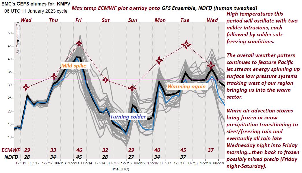
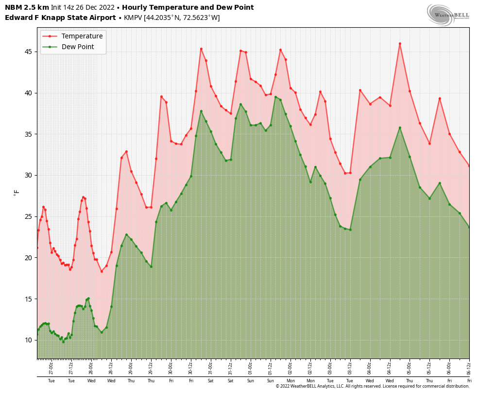
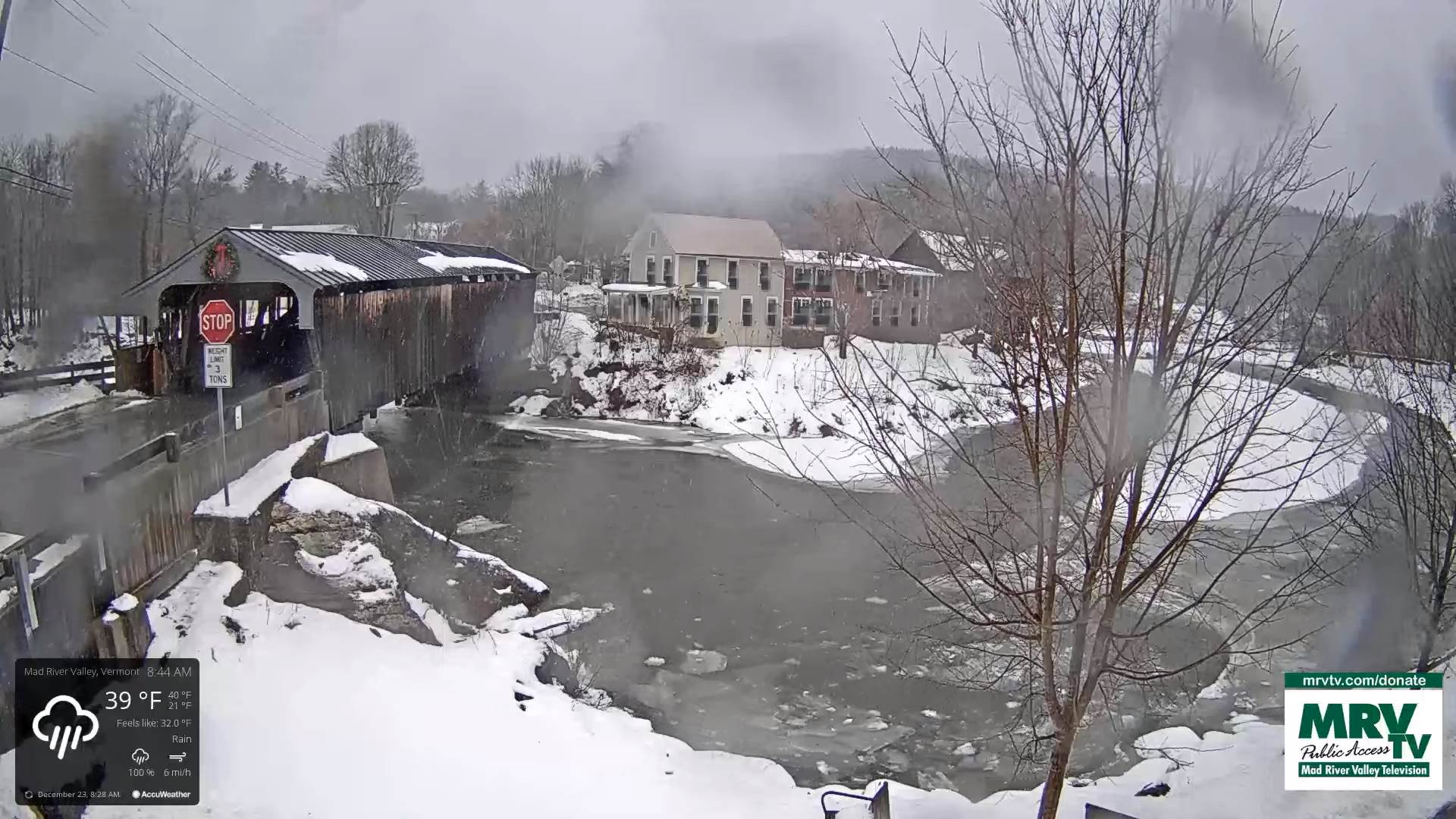
TONIGHT: Overcast. A wintry mix picking back up east of Green Mountains with a transition to rain after midnight. Slick travel likely east of the Green Mountains this evening into the early morning hours. An evening low near 32…gradually rising into the mid to upper 30s. East winds 10 mph.

TOMORROW: Gray but much milder. Occasional light rain with a few icy spots early…mixing with wet snow northern Greens later in the afternoon. A high ranging mid-30s to northwestern Vermont to mid-40s elsewhere. Light winds becoming northwesterly 10 mph in the afternoon.

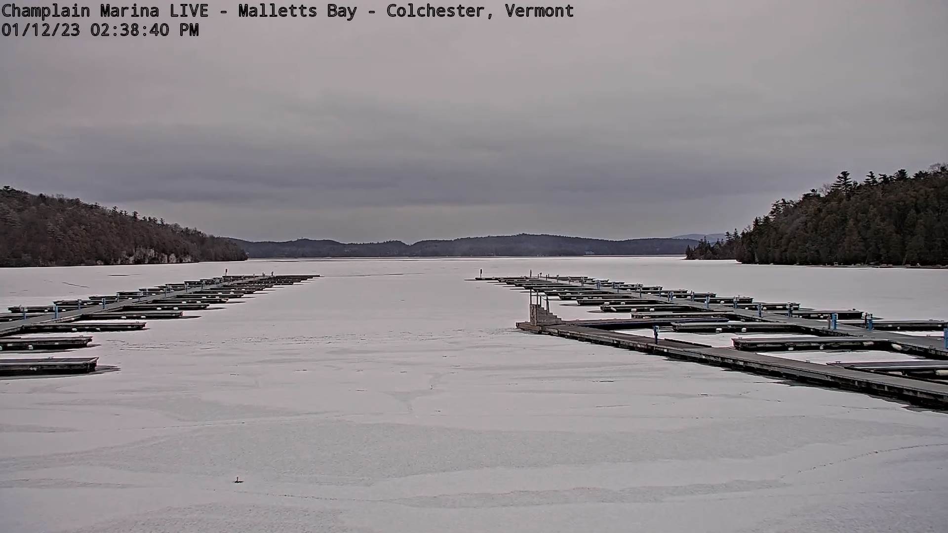
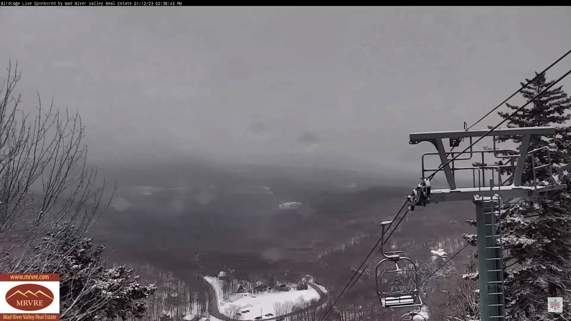
FRIDAY NIGHT: Scattered snow showers/flurries northern Green Mountains exiting with minor accumulation. Otherwise becoming partly cloudy. A low 20 to 25. North winds 10 mph stronger near Lake Champlain.

SATURDAY: Mostly cloudy, maybe a stray mountain flurry. A high mid-20s. North to northwest winds 10 mph…stronger near Lake Champlain.

Looking Further Ahead…

SATURDAY NIGHT: Evening cloudiness, then clearing. A low 5 to 15 above.

SUNDAY: Sunshine predominates, but below normal in temperature. A high mid to upper 20s.

MONDAY: Mostly sunny. A low zero to 10 above. A high near 32 degrees.

TUESDAY: Thickening clouds leading to a chance for rain or snow showers. A low around 10. A high pushing toward 40.

Average lows mid-single digits to around 10 above. Average highs 25 to 30.

Climatological winter peaks approx. January 22nd ends March 9th…

RH/1-10forecast][end]

Updated Thursday Morning Forecast — January 12th, 2023

Winter Weather Advisory this afternoon thru 1 AM Friday morning…

TODAY: Gray skies. Accumulating wet slushy snow showers re-developing toward mid-day. Accumulation of a dusting to an inch or two. A late day high around 35. Southeast winds 10 to occasionally 20 mph.

TONIGHT: Overcast & breezy. A wintry mix generally along and east of Green Mountains with a transition to rain. Slick travel likely east of the Green Mountains. An evening low near 32…gradually rising into the mid to upper 30s. Southeast winds 10 to 15 mph gusty in the higher terrain.

FRIDAY: Mainly cloudy & much milder. Occasional rain showers mixing with wet snowflakes northern Greens late afternoon. A high upper 30s northwestern Vermont & 40 to 45 elsewhere. Light south winds.

Looking Further Ahead…

FRIDAY NIGHT: Chance for snow showers/flurries western slopes of the Green Mountains with accumulation up to an inch. Otherwise becoming partly cloudy. A low around 20.

SATURDAY: Chance for leftover mountain snow showers or flurries early northern Greens, giving way intervals of afternoon sunshine. A high mid to upper 20s.

SUNDAY: Sunshine predominates, but below normal in temperature. A low in the single digits. A high about 25.

MONDAY: Mostly sunny. A low zero to 10 above. A high near 32 degrees.

TUESDAY: Thickening clouds leading to a chance for rain or snow showers. A low around 10. A high pushing toward 40.

Average lows mid-single digits to around 10 above. Average highs 25 to 30.

Climatological winter peaks approx. January 22nd ends March 9th…

RH/1-10forecast][end]

Updated Wednesday Evening Forecast — January 11th, 2023

TONIGHT: Thickening clouds. A few flurries possible northern areas toward daybreak. A low 20 to 25. Light southeast winds a little stronger near Lake Champlain.

TOMORROW: Cloudy. A rising chance for wet snow showers/flurries developing in the afternoon. Some minor accumulation late. A high near 35. Southeast winds 10 to occasionally 20 mph.

THURSDAY NIGHT: Overcast & breezy. A wintry mix generally along and east of Green Mountains with a transition to rain. Slick travel likely east of the Green Mountains. An early low around 32…gradually rising thru the 30s overnight. Southeast winds 10 to 15 mph gusty in the higher terrain.

FRIDAY: Mainly cloudy & much milder. Scattered rain showers mixing with wet snow northern Greens late. A high 45 to 50. Light south winds.

Looking Further Ahead…

FRIDAY NIGHT: Chance for snow showers/flurries western slopes of the Green Mountains with some accumulation. Otherwise more clouds than intervals of sun. A low 15 to 20.

SATURDAY: Mostly cloudy. Chance for leftover mountain snow showers or flurries early northern Greens with light coating. A high upper 20s.

SUNDAY: Sunshine predominates, but below normal in temperature. A low in the single digits. A high about 25.

MONDAY: Mostly sunny. A low 5 to 15 above. A high rebounding into the mid 30s.

Average lows mid-single digits to around 10 above. Average highs 25 to 30.

Climatological winter peaks approx. January 22nd ends March 9th…

RH/1-10forecast][end]

Updated Wednesday Morning Forecast — January 11th, 2023

TODAY: Lots of sun fading behind increasing high clouds in the afternoon. A high in the upper 20s. Light southeast winds.

TONIGHT: Thickening clouds leading to a few flurries toward the Champlain Valley late. A low 20 to 25. Southeast winds 10 mph.

THURSDAY: Cloudy. Scattered light wet snow showers/flurries developing in the afternoon. Little accumulation. A high near 35. Southeast winds 10 to 15 mph.

Looking Further Ahead…

THURSDAY NIGHT: Cloudy & becoming breezy to windy. Periods of wet accumulating snow early with up to a couple 3 inches…transitioning to a wintry mix and eventually rain. Tricky travel east of the Green Mountains. An early low 30 to 32, then temperatures gradually rising thru the 30s overnight.

FRIDAY: Clouds with few hints of sunshine. Wet & mild. Scattered rain showers mixing with wet snow northern western areas late. A high 45 to 50.

SATURDAY: Mostly cloudy. Chance for showers of mixed precipitation with a few slick spots possible. A low mid-20s. A high upper 20s to near 30.

SUNDAY: Sunshine predominates, but below normal in temperature. A low in the single digits. A high upper teens to mid-20s.

Average lows mid-single digits to around 10 above. Average highs 25 to 30.

Climatological winter peaks approx. January 22nd ends March 9th…

RH/1-10forecast][end]

Updated Tuesday Evening Forecast — December 27th, 2022

TONIGHT: Partly cloudy thru midnight, then increasing clouds. A rising chance for flurries toward daybreak. Little accumulation. A low in the mid-teens. Light south to southwest winds.

TOMORROW: Occasional morning flurries with little accumulation. Intervals of sun at times later on. A high near 32. Light south winds stronger near Lake Champlain.

WEDNESDAY NIGHT: Partly cloudy. A low upper teens to mid-20s. Light south winds.

THURSDAY: Clouds giving way to periods of afternoon sunshine. Milder. A high in the mid-40s. Light south winds.

Looking Further Ahead…

THURSDAY NIGHT: Partly cloudy early, then more clouds. An evening low 30 to 32 temperature moderating upward overnight.

FRIDAY: Considerable cloudiness. A high mid to upper 40s.

SATURDAY: Chance for an occasional sprinkle northern areas. Watch for icy spots colder hollows east of the Greens early, otherwise gray. A low near 35. A high about 45.

SUNDAY: Gray. Areas of fog. Chance for rain or showers moderate at times early…exiting in the afternoon with breaks of sun.. A low 35 to 40. A high mid-40s to near 50.

Average lows 5 to 15 above. Average highs mid-20s to near 30.

Climatological winter peaks approx. January 22nd ends March 9th…

RH/12-27forecast][end]

Updated Tuesday Morning Forecast — December 27th, 2022

TODAY: Clouds with breaks of sunshine away from the mountains Scattered snow showers & valley flurries mainly northern areas this morning, A few stray flurries northern Greens this afternoon with about a dusting to an inch. A high mid-to upper 20s. West to southwest winds 10 to 15 mph.

TONIGHT: Scattered clouds to mostly clear in the evening, then increasing clouds. A rising chance for light accumulating snow showers/flurries after midnight. Minor accumulation. A low in the teens. Light southwest winds.

WEDNESDAY: Scattered mainly morning flurries with minor accumulation. Partial sunshine at times. A high 30 to 35. Light south winds stronger near Lake Champlain.

Looking Further Ahead…

WEDNESDAY NIGHT: Partly cloudy. A low in the low to mid 20s.

THURSDAY: Partly to mostly cloudy becoming milder. A high 40 to 45.

FRIDAY: Considerable cloudiness. A low near 30. A high mid to upper 40s.

SATURDAY: Cloudy. Chance for a few sprinkles, possible icy slick spots in the morning. A low 32 to 35. A high around 45.

SUNDAY: Gray. Chance for periods of light rain or showers. Areas of fog. A low 35 to 40. A high mid-40s.

Average lows 5 to 15 above. Average highs mid-20s to near 30.

Climatological winter peaks approx. January 22nd ends March 9th…

RH/12-26forecast][end]

Updated Monday Evening Forecast — December 26th, 2022

TONIGHT: Considerable cloudiness. Occasional northern mountain snow showers and valley flurries. A dusting to an inch except up to 3 inches northern Green Mountains. A low 10 to 15. Light southwest winds.

TOMORROW: Clouds with breaks of sunshine away from the mountains. Scattered snow showers
& valley flurries northern areas.
A high near 25. West breeze 10 mph.

TUESDAY NIGHT: Scattered clouds to mostly clear in the evening, then increasing clouds. A rising chance for light accumulating snow showers/flurries. A low around 10. Light southwest winds.

WEDNESDAY: Chance for flurries early & again later on. Partial sunshine at times. A high around 32 degrees. Light south winds stronger near Lake Champlain.

Looking Further Ahead…

WEDNESDAY NIGHT: Partly cloudy. A low in the low to mid 20s.

THURSDAY: Partly to mostly cloudy becoming milder. A high in the low 40s.

FRIDAY: Considerable cloudiness. A low near 30. A high 45 to 50.

SATURDAY: Sunshine mixing with more clouds. A low in the low to mid 30s. A high mid to upper 40s.

Average lows 5 to 15 above. Average highs mid-20s to near 30.

Climatological winter peaks approx. January 22nd ends March 9th…

RH/12-26forecast][end]

Updated Monday morning Forecast — December 26th, 2022

TODAY: Clouds mixed with intervals of sun before clouding up. A few northern flurries. A high about 25. West to southwest winds 10 mph.

TONIGHT: Considerable cloudiness. Occasional northern mountain snow showers and valley flurries. A dusting to an inch except up to 3 inches northern Green Mountains. A low 10 to 15. Light southwest winds.

TUESDAY: Clouds with breaks of sunshine away from the mountains. Scattered snow showers
& valley flurries northern areas.
A high near 25. West breeze 10 mph.

Looking Further Ahead…

TUESDAY NIGHT: Scattered clouds to mostly clear in the evening, then increasing clouds. A rising chance for light accumulating snow showers/flurries. A low around 10.

WEDNESDAY: Chance for flurries early & again later on. Partial sunshine at times. A high around 32 degrees.

THURSDAY: Partly to mostly cloudy becoming milder. A low in the low to mid 20s. A high in the low 40s.

FRIDAY: Considerable cloudiness. A low near 30. A high 45 to 50.

SATURDAY: Sunshine mixing with more clouds. A low in the low to mid 30s. A high mid to upper 40s.

Average lows 5 to 15 above. Average highs mid-20s to near 30.

Climatological winter peaks approx. January 22nd ends March 9th…

RH/12-26forecast][end]

Updated Friday Evening Forecast — December 23rd, 2022

Flood Warning for the central and northern Green Mountains thru this late afternoon. Flood Watch continues into Saturday evening with rising streams/rivers.

TONIGHT: Rain showers rapidly transition to a round of snow showers/squalls…with a quick coating of snow, possible white-outs…and a “Flash-Freeze hazard” for travel. Variably cloudy otherwise. A low bottoms out around 5 above. Winds shifting to southwesterly 10 to 25 mph and gusty lowering wind chills.

TOMORROW: Lots of clouds but a few breaks of sunshine away from the mountains and blustery. A high in the low to mid-teens. Southwest winds 10 to 20 mph lowering wind chills.

SATURDAY NIGHT Christmas Eve: Lots of clouds & a bit blustery. Chance for a brief flurry. A low 5 to 10 above. Winds continue southwesterly 10 to 15 mph lowered wind chills.

SUNDAY Christmas Day: Clouds with a few intervals of sunshine & still blustery. Maybe a northern border flurry. A high in the lower 20s. Southwest winds 10 to 20 mph

Looking Further Ahead…

SUNDAY NIGHT: Mostly cloudy north, partly cloudy elsewhere. Scattered northern mountain snow showers and flurries with a light coating in spots. A low near 10.

MONDAY: Clouds mixing with intervals of sunshine. A few northern flurries. A high about 25.

TUESDAY: Partly to mostly cloudy. Chance for snow showers or flurries with minor accumulation. A low 5 to 10 above. A high 20 to 25.

WEDNESDAY: Partly sunny. Chance for flurries. A low 5 above to 5 below. A high about 25.

Average lows upper single digits to mid-teens. Average highs mid-20s to mid-30s

Climatological winter peaks approx. January 22nd ends March 9th…

RH/12-21forecast][end]

Updated Friday Morning Forecast — December 23rd, 2022

High Wind Warnings and Wind Advisories expire late today. Flood Watch this afternoon thru Saturday evening with rising streams/rivers.

TODAY: Gray. Periods of wind-blown rain, or showers moderate at times. Much milder as temperatures rise to almost 50. Southeasterly winds 15 to 30 mph with gusts exceeding 50 mph strongest for a time morning…decreasing some for the afternoon.

TONIGHT: Mainly cloudy. Rain showers rapidly transitions to a round of snow showers/squalls…moderate to briefly heavy with a quick coating of snow…and a “Flash-Freeze condition producing hazardous travel. A low around 5 above. Winds shifting to southwesterly 10 to 25 mph and gusty lowering wind chills.

SATURDAY: Lots of clouds but a few breaks of sunshine away from the mountains. A high in the low to mid-teens. Southwest winds 10 to 20 mph.

Looking Further Ahead…

SATURDAY NIGHT Christmas Eve: Lots of clouds. Chance for a brief flurry. A low 5 to 10 above.

SUNDAY Christmas Day: Clouds with a few intervals of sunshine. Maybe a northern border flurry. A high in the lower 20s.

MONDAY: Clouds mixing with intervals of sunshine. A few northern flurries. A low near 10. A high about 25.

TUESDAY: Partly to mostly cloudy. Chance for snow showers or flurries with minor accumulation. A low 5 to 10 above. A high 20 to 25.

WEDNESDAY: Partly sunny. Chance for flurries. A low 5 above to 5 below. A high about 25.

Average lows upper single digits to mid-teens. Average highs mid-20s to mid-30s

Climatological winter peaks approx. January 22nd ends March 9th…

RH/12-21forecast][end]