
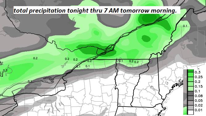
TONIGHT: Mainly cloudy. Passing rain showers mixed with a few wet snow flakes this evening Barre-Montpelier area north – Watch for icy spots developing! Temperatures in the low and mid 30s. Light southwest winds.
TOMORROW: Clouds give way to periods of afternoon sunshine. A high upper 30s to near 40. Winds becoming northwesterly 10 to 15 mph.
SATURDAY NIGHT: Mostly clear with more clouds near the mountains. Colder. A low in the single digits. Little wind.
SUNDAY: Morning sun then increasing clouds. Mixed precipitation with slick travel developing far southern areas. A high in the mid 30s. Light southeast winds.
Looking further ahead…
SUNDAY NIGHT: Cloudy. Occasional light snow or snow showers. Accumulation dusting to 2 inches most toward the south. A low in the 20s.
MONDAY: Gray skies. Scattered flurries especially in the mountains with additional minor accumulation possible. A high near 35.
TUESDAY: Mostly cloudy, much colder and blustery. Chance for lingering flurries and mountain snow showers. Some minor accumulation. Lowering wind chills. Temperatures in the teens.
WEDNESDAY: Mixed clouds and sun. A low in the single digits. A high in the 20s.
THURSDAY: Lots of sunshine, giving way to increasing clouds. A low in the teens. A high pushing near 40.
Average lows mid teens to around 20. Average highs ranging 30 to 35.
RH/12-14[end]
