TONIGHT: Mostly cloudy with a leftover stray flurry near the mountains early. A low 10 to 15. Light southeast winds.
Winter Storm Warning 10 AM Thursday through 1 PM Friday afternoon.
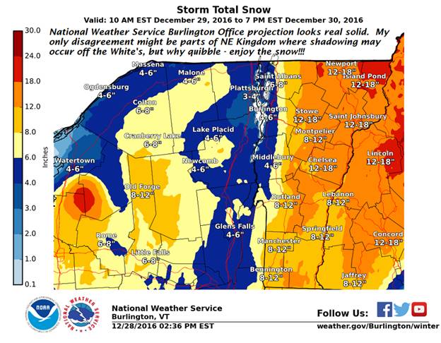
TOMORROW: Gray. Accumulating snow…arriving late morning-mid day. Accumulation about 2-3” by late in the day. A high in the upper 20s. Southeast winds 10 to 15 mph.
THURSDAY NIGHT: Overcast and becoming blustery.Accumulating snow…moderate to heavy at times. Additional accumulation 5-8”. Temperatures in the mid 20s. Light winds becoming west to northwest winds 10 to 20 mph.
FRIDAY: Blustery with Accumulating snow early. Scattered mountain snow showers and valley flurries late morning into the afternoon, with some additional accumulation. Total Snowfall 6-14. Maybe a few breaks/intervals of sun late.Temperatures holding in the mid 20s.Gusty west winds 10 to 25 mph producing blowing and drifting and local white-outs exposed areas.
Looking Further ahead…
FRIDAY NIGHT: Mostly cloudy. Any mountain flurries exiting overnight. A low 5 below to 5 above.
SATURDAY: A few intervals of morning sun, then cloudy. Scattered flurries or periods of very light snow with little accumulation. A high 25 to 30.
NEW YEARS EVE: Cloudy. Scattered light snow showers or flurries and blustery. Temperatures in the mid to upper 20s.
SUNDAY NEW YEARS DAY: Mixed clouds than sun. Chance for a morning flurry early.A low in the mid 20s. A high in the mid 30s.
MONDAY: Partial morning sun then clouding up. Chance for mixed sleet or snow showers. Turning breezy. A low 5 to 10. A high around 30.
TUESDAY: Gray and breezy with mixed precipitation producing treacherous travel. A low 25 to 30. A high in the mid 30s.
Average lows upper single digits to low teens. Normal highs upper 20s to around 30.RH/12-27[end]