
· Biggest snowfall in couple of years for a lot of us with strong deepening low pressure getting its act together through the day and then hugging the Maine coast tracking toward Houlton Maine. This will put maximum snowfalls across New Hampshire and Maine and but still healthy though more fringe effects of snow in Vermont.
· Heaviest meso-banding likely Connecticut River Valley into the eastern Northeast Kingdom late today and especially tonight.
· As low departs while deepening, winds will kick up newly fallen snows with potential for white-outs across exposed area, but travel will be “snowy” no matter and likely some without snow tires will go off the road and there should likely be many areas at a crawl later today and again tomorrow morning.
· Storms departs conditions improve from south to north, but up-slope component will continue to unload locally heavy snowfall for the central and northern Green Mountains during the storms tail end making skiers and winter enthusiasts extremely grateful.
Winter Storm Warning 10 AM Thursday through 1 PM Friday afternoon.
TODAY: Gray. Accumulating snow…arriving late morning-mid day. Accumulation about 2-4” by late in the day. A high in the upper 20s. Southeast winds 10 to 15 mph.
TONIGHT: Overcast and becoming blustery.Accumulating snow…moderate to heavy at times. Additional accumulation 3-7”. Temperatures in the mid 20s. Light winds becoming west to northwest winds 10 to 20 mph.
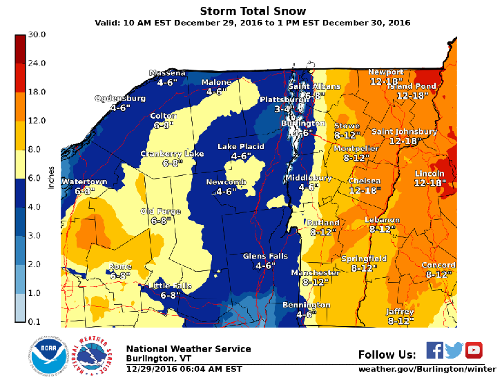
FRIDAY: Blustery with Accumulating snow early. Scattered mountain snow showers and valley flurries late morning into the afternoon, with additional accumulation. Maybe a few breaks/intervals of sun late.Temperatures holding in the mid 20s.Gusty west winds 10 to 25 mph producing blowing and drifting and local white-outs exposed areas.Total Snowfall 7-14 with localized amounts to near 20”.
Looking Further ahead…
FRIDAY NIGHT: Any mountain flurries exiting, then partial clearing but much colder. A low 5 below to 5 above.
SATURDAY: A few intervals of morning sun, then cloudy. Scattered flurries or periods of very light snow with little accumulation arriving late in the day. A high in the upper 20s.
NEW YEARS EVE: Cloudy. Scattered light snow showers or flurries and blustery. Temperatures in the mid to upper 20s.
SUNDAY NEW YEARS DAY: Maybe a morning flurry. Otherwise becoming partly to mostly sunny.. A low in the mid 20s. A high near 32.
MONDAY: Partial morning sun then clouding up. Chance for mixed sleet or snow showers. Turning breezy. A low in the single digits. A high around 30.
TUESDAY: Gray and breezy with mixed precipitation producing treacherous travel. A low 25 to 30. A high near 35.
Average lows upper single digits to low teens. Normal highs upper 20s to around 30. RH/12-29
[end]
