Updated Thursday Evening Forecast — March 29th, 2018

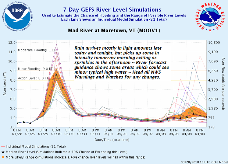
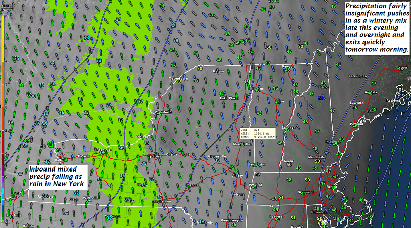
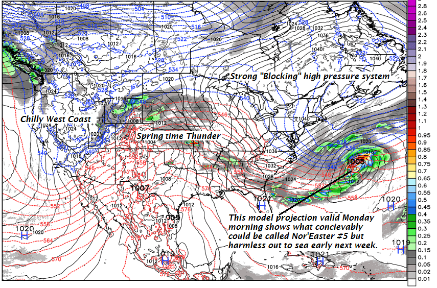
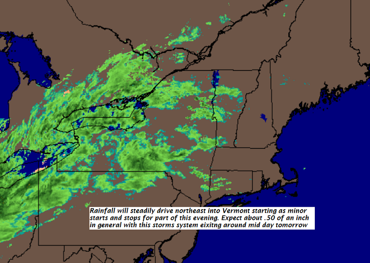
TONIGHT: Cloudy. Periods of light rain, moderate at times toward daybreak. Areas of fog. A low upper 30s to low 40s. Light southeast winds.

TOMORROW: Rain…moderate at times in the morning, tapering to scattered sprinkles before exiting in the afternoon. Watch for rising streams and river levels. Breaks of late day sun.A high 45 to 50. Northwest winds 10 to 20 mph in the afternoon.

FRIDAY NIGHT: Mostly clear and fully moonlit. A bit blustery and colder. A low around 20. Northwest winds 10 to 20 mph diminishing overnight.

Full “Sap Moon“ 8:37 AM

SATURDAY: Partly to mostly sunny. A high in the mid to upper 40s. West breeze 10 to 15 mph.

Looking further Ahead…

SATURDAY NIGHT: Increasing clouds. Quick shot of rain…mixed with wet snow overnight.. tapering to a few mountain flurries. A dusting up to an inch higher terrain. A low in the low 30s.

EASTER SUNDAY: A few mountain flurries exit, then becoming partly sunny and colder. A high in the mid to upper 30s.

MONDAY: Partly sunny and colder. A low in the teens. A high in the mid 30s.

TUESDAY: Clouding up. Chance for wet snow mixed with rain in the afternoon. Some accumulation possible higher terrain. A low around 20. A high in the low 40s.

Average lows mid to upper 20s. Normal highs in the mid to 40s to around 50

RH/3-29[end]

Virus-free. www.avast.com

Updated Thursday morning forecast — March 29th, 2018

TODAY: Maybe a break of sun otherwise gray. Light rain overspreading the region southwest to northeast this later afternoon. Milder. A high 50 to 55. Light south wind.

TONIGHT: Cloudy. Periods of light rain, moderate at times toward daybreak. Areas of fog. A low mid 30s to lower 40s. Light southeast winds.

FRIDAY: Rain…moderate at times in the morning, tapering to scattered sprinkles before exiting in the afternoon. Watch for rising streams and river levels. Breaks of late day sun.A high upper 40s to around 50. Northwest winds picking up 10 to 20 mph in the afternoon.

Looking further Ahead…

FRIDAY NIGHT: Clear and fully moonlit. A bit blustery and colder. A low around 20.

Full “Sap Moon“ 8:37 AM

SATURDAY: Clouds mixed with sun. A high in the mid to upper 40s.

EASTER SUNDAY: Wet snow showers mixedwith rain valley floors. Some minor accumulation higher terrain. Blustery with breaks of sun possible in the afternoon. A low around 35. A high near 40.

MONDAY: Partly sunny and colder. A low in the teens. A high in the mid 30s.

TUESDAY: Mostly cloudy. Chance for wet snow showers developing in the afternoon…mixed with rain valley floors. A low around 20. A high in the low 40s.

Average lows mid to upper 20s. Normal highs in the mid to 40s to around 50

RH/3-29[end]

Virus-free. www.avast.com

Updated Wednesday evening Forecast — March 28th, 2018

TONIGHT: Partly cloudy.A low in the low to mid 30s. Little wind.

TOMORROW: Brief partial morning sun then clouding up. Light rain becoming likely late. Milder. A high 50 to 55, warmest western and southern areas. Light south wind.

THURSDAY NIGHT: Cloudy. Periods of light rain. Areas of fog. A low in the mid to upper 30s. Light southeast winds.

FRIDAY: Rain showers…possibly mixed with wet snow flakes higher northern terrain early, Becoming partly sunny later on. A high 45 to 50. Northwest winds 10 to 20 mph.

Looking further Ahead…

FRIDAY NIGHT: Mostly clear a bit blustery in the evening. A low around 20.

Full “Sap Moon“ 8:37 AM

SATURDAY: Clouds mixed with sun. A high 45 to 50.

EASTER SUNDAY: Chance for a round wet snow showers mixed with rain valley floors. A skiff of accumulation across higher elevations. Blustery with breaks of sun possible in the afternoon. A low near 32. A high in the 40s.

MONDAY: Partly sunny and colder. A low in the teens. A high in the 30s.

Average lows in the 20s. Normal highs in the mid to upper 40s

RH/3-28[end]

Virus-free. www.avast.com

Updated Wednesday morning Forecast — March 28th, 2018

TODAY: Any wet snow flakes or sprinkles exiting. Cloudsgradually give way to some intervals of late afternoon sun. A high upper 40s to around 50. Little wind. (Sap run)

TONIGHT: Partly cloudy.A low 30 to 35. Little wind.

THURSDAY: Brief partial morning sun then clouding up. Light rain becoming likely late. Milder. A high 50 to 55, warmest western and southern areas. Light south wind.

Looking further Ahead…

THURSDAY NIGHT: Cloudy. Periods of light rain. Areas of fog. A low in the mid to upper 30s.

FRIDAY: Rain showers…possibly mixed with wet snow flakes higher northern through in the morning, Becoming partly sunny later on. A high 45 to 50.

Full “Sap Moon“ 8:37 AM

SATURDAY: Clouds mixed with sun. A low around 20. A high 45 to 50.

EASTER SUNDAY: Chance for a round wet snow showers mixed with rain valley floors. A skiff of accumulation across higher elevations. Blustery with breaks of sun possible in the afternoon. A low near 32. A high in the 40s.

MONDAY: Partly sunny and colder. A low in the teens. A high in the 30s.

Average lows in the 20s. Normal highs in the mid to upper 40s

RH/3-28[end]

Virus-free. www.avast.com

Updated Tuesday Evening forecast — March 27th, 2018

TONIGHT: Cloudy. Occasional light wintery mix arriving later this evening. Watch for slick travel especially east of the Green Mountains. A low around freezing or 32. Southeast winds 10 mph.

TOMORROW: A couple leftover rain showers exiting mid morning, otherwise clouds gradually giving way to some intervals of late afternoon sun. A high mid to upper 40s. Little wind. (Sap run)

WEDNESDAY NIGHT: Partly cloudy.A low 30 to 35. Little wind.

THURSDAY: A few breaks of morning sun, then overcast. A rising chance for light rain toward evening. A high ranging in the upper 40s to low 50s, warmest southern areas. Light south wind.

Looking further Ahead…

THURSDAY NIGHT: Cloudy. Periods of light rain. Areas of fog. A low in the mid to upper 30s.

FRIDAY: Rain showers…possibly mixed with wet snow flakes higher northern through in the morning, Becoming partly sunny later on. A high 45 to 50.

Full Sap Moon 8:37 AM

SATURDAY: Clouds mixed with sun. A low around 20. A high 45 to 50.

EASTER SUNDAY: Mostly cloudy. Chance for rain or wet snow showers. A low 25 to 30. A high mid 40s to around 50.

Average lows in the 20s. Normal highs in the mid to upper 40s

RH/3-27[end]

Virus-free. www.avast.com

Updated Tuesday morning forecast — March 27th, 2018

TODAY: Sunshine becoming filtered by high clouds thickening up later this afternoon. Near seasonal temperatures. A high in the mid to upper 40s. Light winds. (Sap Run)

TONIGHT: Cloudy. A rising chance for a light wintery mix producing slick travel late evening on east of the Green Mountains. A low in the lower 30s. South winds 10 mph.

WEDNESDAY: Chance for rain shower early, then clouds give way to afternoon intervals of sunshine. A high mid to upper 40s. Little wind. (Sap run)

Looking further Ahead…

WEDNESDAY NIGHT: Fair and dry but with high cloudiness. A low around 35.

THURSDAY: Gray. Isolated sprinkles developing…with occasional light rain in the afternoon. Areas of fog. A high ranging in the low 40s to around 50 warmest toward southern areas.

FRIDAY: Rain showers mixed with wet snow flakes across the higher terrain early, Otherwise becoming partly sunny. A low in the mid to upper 30s. A high in the mid 40s to near 50.

Full Sap Moon 8:37 AM

SATURDAY: Clouds mixed with sun. A low around 20. A high in the mid to upper 40s

EASTER SUNDAY: Sunshine giving way to clouds. Chance for rain or wet snow developing late. A low 25 to 30. A high around 50.

Average lows in the 20s. Normal highs in the mid to upper 40s

RH/3-27[end]

Virus-free. www.avast.com

Updated Monday Evening Forecast — March 26th, 2018

TONIGHT: Clear & partially moonlit. A low in the lower teens to low 20s. Light southeast winds.

TOMORROW: Sunshine becoming filtered by high clouds. A high mid 40s to near 50. Light winds. (Sap Run)

TUESDAY NIGHT: Thickening clouds. A rising chance for a light wintery mix producing slick travel toward daybreak east of the Green Mountains. A low in the lower 30s. South winds 10 mph.

WEDNESDAY: Chance for rain shower early, then considerable cloudiness. A high mid to upper 40s. Little wind. (Sap run)

Looking further Ahead…

WEDNESDAY NIGHT: Mostly cloudy. A low around 35.

THURSDAY: Gray. Isolated sprinkles developing…with occasional light rain in the afternoon. Areas of fog. A high ranging in the low 40s to around 50 warmest toward southern areas.

FRIDAY: Rain showers mixed with wet snow flakes across the higher terrain early, Otherwise becoming partly sunny. A low in the mid to upper 30s. A high in the upper 40s to mid 50s.

SATURDAY: Clouds mixed with sun. A low around 20. A high around 45.

EASTER SUNDAY: Sunshine giving way to clouds. Chance for rain developing late. A low in the low 20s. A high in the low 50s.

Average lows in the 20s. Normal highs in the mid to upper 40s

RH/3-26[end]

Virus-free. www.avast.com

Updated Monday morning Forecast — March 26th, 2018

TODAY: Pick of the week. Sunny and gorgeous. A high in the low 40s. Little wind. (Maybe a sap run)

TONIGHT: Clear & partially moonlit. A low mid teens to low 20s. Light southeast winds.

TUESDAY: Sunshine becoming filtered by high clouds. A high near 45. Light northwest winds.

Looking further Ahead…

TUESDAY NIGHT: Thickening clouds. A rising chance for a light wintery mix producing slick travel toward daybreak. A low in the low 30s.

WEDNESDAY: Chance for rain shower early, then mainly cloudy. A high mid to upper 40s. (Maybe a sap run)

THURSDAY: Considerable cloudiness. Chance for light rain developing toward evening. A morning low close to 32. A high mid 40s to low 50s.

FRIDAY: Morning clouds with slight chance for passing rain shower. Partial afternoon sun developing. A low in the 30s. A high 50 to 55.

Average lows in the 20s. Normal highs in the mid to upper 40s

RH/3-26[end]

Virus-free. www.avast.com

Updated Friday Evening forecast — March 23rd, 2018

TONIGHT: Considerable cloudiness. A few stray flurries toward the Champlain valley overnight. A low upper teens to mid 20s. Northwest winds 10 mph.

TOMORROW: Clouds with a few breaks of sun possible. A stray flurry or two across mainly northern areas in the afternoon. A high 30 to 35. Northwest winds 10 to 15 mph.

SATURDAY NIGHT: Mostly cloudy with widely scattered light snow showers or flurries with a dusting to less than an inch. A low 15 to 20. Light north winds.

SUNDAY: A stray flurry or two early, Otherwise intervals of afternoon sunshine. A high in the mid to upper 30s. Northeast winds 10 mph.

Looking further Ahead…

SUNDAY NIGHT: Clear & partially moonlit. A low in the teens.

MONDAY: Mostly sunny. Start of a warming trend. A high around 40. (Maybe a sap run)

TUESDAY: Sunshine filtered by high clouds. A low in the teens. Milder in the afternoon. A high 45 to 50. (Sap run)

WEDNESDAY: Partly sunny then clouding up. Chance for light rain showers arriving late. Above normal temperatures. A low around 20. A high 45 to 50. (Sap run)

THURSDAY: Considerable cloudiness. Chance for sprinkles. A low in the mid to upper 30s. A high 50 to 55.

Average lows upper teens to mid 20s. Normal highs upper 30s to mid 40s.

RH/3-23[end]

Virus-free. www.avast.com

Updated Friday Morning Forecast — March 23rd, 2018

TODAY: More clouds than sun. A high in the upper 30s to near 40. Northwest winds 10 to 15 mph.

TONIGHT: Considerable cloudiness. A low mid teens to low 20s. Northwest winds 10 mph.

SATURDAY: Clouds with a few breaks of sun possible. A stray flurry or two across mainly northern areas. A high 30 to 35. Northwest winds 10 to 15 mph.

Looking further Ahead…

SATURDAY NIGHT: Mostly cloudy with widely scattered light snow showers or flurries with a dusting to an inch. A low in the teens.

SUNDAY: A few leftover stray flurries. Otherwise lots of clouds… giving way to intervals late afternoon sunshine. A high in the mid to upper 30s.

MONDAY: Mostly sunny. Start of a warming trend. A low in the teens. A high near 40. (Maybe a sap run)

TUESDAY: Sunshine becoming filtered by high clouds. A low in the teens. Milder. A high in the mid to upper 40s. (Sap run)

WEDNESDAY: Sunshine mixed with clouds. Above normal temperatures. A low around 20. A high around 50.

THURSDAY: Considerable cloudiness. Chance for sprinkles. A low in the 30s. A high in the 50s.

Average lows upper teens to mid 20s. Normal highs upper 30s to mid 40s.

RH/3-23[end]

Virus-free. www.avast.com