
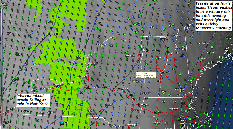
TONIGHT: Cloudy. Occasional light wintery mix arriving later this evening. Watch for slick travel especially east of the Green Mountains. A low around freezing or 32. Southeast winds 10 mph.
TOMORROW: A couple leftover rain showers exiting mid morning, otherwise clouds gradually giving way to some intervals of late afternoon sun. A high mid to upper 40s. Little wind. (Sap run)
WEDNESDAY NIGHT: Partly cloudy.A low 30 to 35. Little wind.
THURSDAY: A few breaks of morning sun, then overcast. A rising chance for light rain toward evening. A high ranging in the upper 40s to low 50s, warmest southern areas. Light south wind.
Looking further Ahead…
THURSDAY NIGHT: Cloudy. Periods of light rain. Areas of fog. A low in the mid to upper 30s.
FRIDAY: Rain showers…possibly mixed with wet snow flakes higher northern through in the morning, Becoming partly sunny later on. A high 45 to 50.
Full Sap Moon 8:37 AM
SATURDAY: Clouds mixed with sun. A low around 20. A high 45 to 50.
EASTER SUNDAY: Mostly cloudy. Chance for rain or wet snow showers. A low 25 to 30. A high mid 40s to around 50.
Average lows in the 20s. Normal highs in the mid to upper 40s
RH/3-27[end]
| Virus-free. www.avast.com |
