Updated Friday Morning Forecast — January 18th, 2019

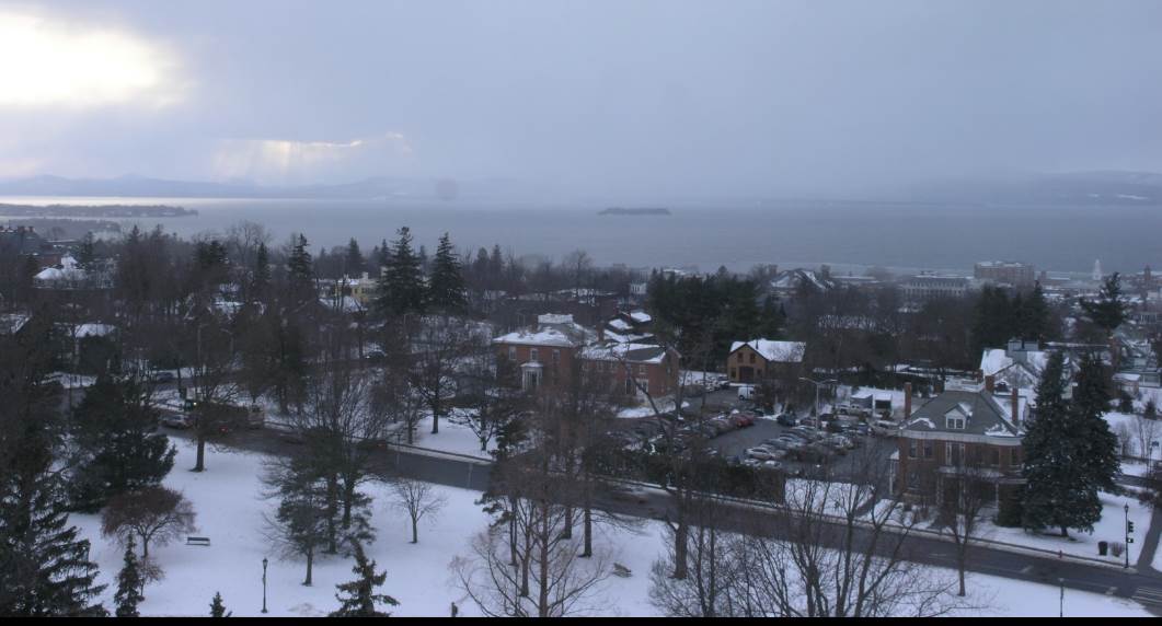
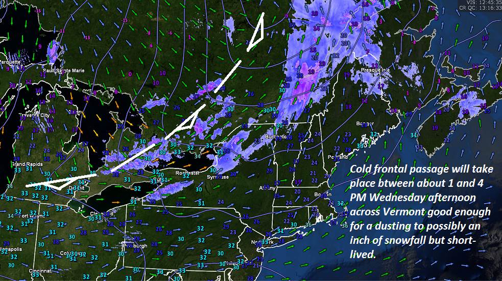
TODAY: Gray skies. Scattered flurries this morning. Flurries and a few snow showers this afternoon with an inch or less accumulation. Not so cold with a high around 32. South winds 10 to 15 mph.

TONIGHT: Scattered evening flurries mountain snow showers winding down with minor accumulation. A low 5 below north and zero to 5 above south. Northwest winds 10 to 20 mph lowering wind chills.

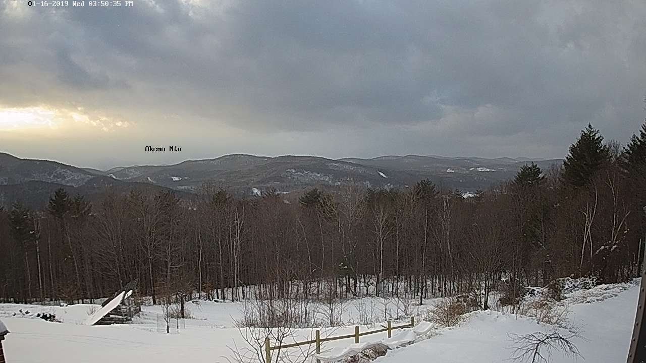
SATURDAY: Sunshine giving way to thickening high clouds. Rising likelihood for light snow developing before dark. A high 10 to 15. Light north winds.

Looking further Ahead…

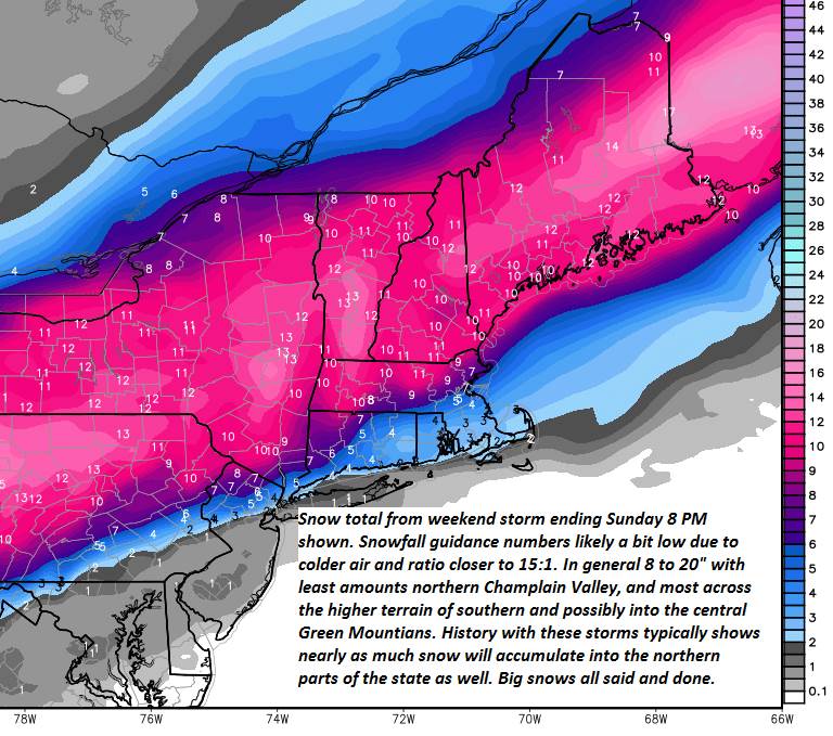
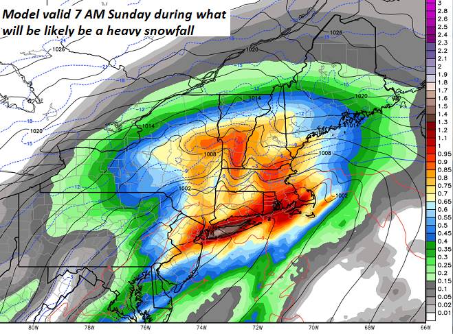
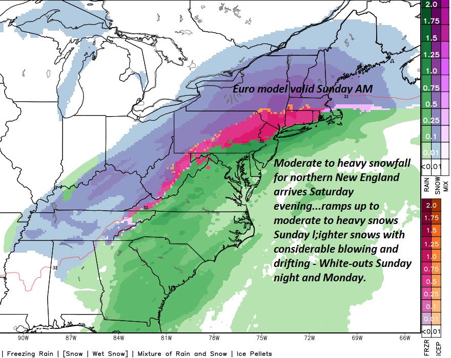
Winter Storm Warning 4 PM Saturday through 4 PM Sunday

SATURDAY NIGHT: Snow moderate to heavy at times. Accumulation 6 to 12 inches. A low 5 to 10 above.

SUNDAY: Snow…moderate to heavy in the morning…gradually lighter in the afternoon. Significant accumulation likely 8 to 20 with more possible southern Vermont”. Otherwise gray. An early high in the low teens then colder with bitterly cold wind chills.

Full Wolf Moon 12:16 AM Monday

MONDAY: Lots of clouds. Light snow showers or flurries near the mountains with some minor additional accumulation. Intervals of sunshine away from the mountains. Bitterly cold dangerous wind chills. Temperatures zero to 10 below.

TUESDAY: Mostly sunny followed by high cloudiness in the afternoon. A low zero to 10 below. A high in the low teens.

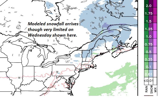
WEDNESDAY: Clouding up. Chance for accumulating snowfall. A low single digits. A high in the 20s.

Average lows single digits. Average highs in the 20s.

RH/1-18-19[end]

Updated Thursday Evening Forecast — January 17th, 2019

TONIGHT: Fair this evening. Thickening clouds leading to rising chance for light accumulating snow showers. A low 5 to 10 above zero. Southeast winds 10 to 15 mph overnight

TOMORROW: Gray. Periods of light snow, or snow showers. Around an inch of accumulation. Not so cold. A high in the lower 30s. South winds 10 to 15 mph.

FRIDAY NIGHT: Partly cloudy. Chance for lingering evening snow showers or flurries. Less than an inch of accumulation. A low 5 below north and zero to 5 above south. Northwest winds 10 to 20 mph lowering wind chills.

SATURDAY: Sunshine giving way to thickening high clouds. Slight chance for flurries late. A high in the single digits above zero. Light north winds.

Looking further Ahead…

Winter Storm Watch Saturday evening into late Sunday night

SATURDAY NIGHT: Light snow developing into the evening becoming moderate to heavy. Several or more inches of accumulation. A low 5 above to 5 below.

SUNDAY: Snow…moderate to heavy into the early afternoon. Significant accumulation likely 12 to 24”…otherwise cloudy and gray. A high in the mid-single digits northern areas to low teens toward Rutland.

Full Wolf Moon 12:16 AM Monday

MONDAY: Lots of clouds. Light snow with some minor additional accumulation with hints of sun and blustery and bitterly cold and dangerous wind chills possible. A low zero to 15 below. A high near zero degrees.

TUESDAY: Mostly sunny followed by high cloudiness in the afternoon. A low zero to 10 below. A high in the low teens.

WEDNESDAY: Clouding up. Chance for accumulating snowfall. A low single digits. A high in the 20s

Average lows single digits. Average highs in the 20s.

RH/1-17-19[end]

Updated Thursday morning Forecast — January 17th, 2019

TODAY: Sunshine gives way to increasing high cloudiness in the afternoon. A high 10 to 15. Little wind.

TONIGHT: Fair this evening. Thickening clouds leading to rising chance for light accumulating snow showers. A low 5 to 10 above zero. Southeast winds 10 to 15 mph overnight

FRIDAY: Gray. Periods of light snow, or snow showers. Around an inch of accumulation. Not so cold. A high in the lower 30s. South winds 10 to 15 mph.

Looking further Ahead…

FRIDAY NIGHT: Partly cloudy. Chance for lingering evening snow showers or flurries. Less than an inch of accumulation. A low close to zero degrees.

SATURDAY: Sunshine giving way to thickening high clouds. Snow likely toward midnight. A high in the single digits above zero.

Winter Storm Watch Saturday evening into late Sunday night

SUNDAY: Snow…significant accumulation likely greater than 8”…otherwise cloudy and gray. A low 5 above to 5 below. A high in the mid-single digits northern areas to low teens toward Rutland.

Full Wolf Moon 12:16 AM Monday

MONDAY: Lots of clouds. Light snow with some minor additional accumulation with hints of sun and blustery and bitterly cold and dangerous wind chills possible. A low zero to 15 below. A high near zero degrees.

TUESDAY: Mostly sunny followed by high cloudiness in the afternoon. A low zero to 10 below. A high in the low teens.

WEDNESDAY: Clouding up with a chance for accumulating snowfall. A low single digits. A high in the 20s

Average lows single digits. Average highs in the 20s.

RH/1-17-19[end]

Updated Wednesday Evening Forecast — January 16th, 2019

Wind Chill Advisory Northeast Kingdom tonight into Thursday morning…

TONIGHT: Lingering mountain cloudiness with a few stray flurries this evening. Gradually clearing. Frigid. A low zero to 10 below. Northwest winds 10 to 15 mph lowering wind chills gradually diminishing.

TOMORROW: Sunshine gives way to increasing high cloudiness in the afternoon. A high 10 to 15. Little wind.

THURSDAY NIGHT: Fair early with thickening clouds leading to rising chance for light accumulating snow. A low in the single digits above zero. Southeast winds 10 to 15 mph overnight

FRIDAY: Gray. Good chance for light snow or snow showers around an inch of accumulation. A high upper 20s to low 30s. South winds 10 to 15 mph.

Looking further Ahead…

FRIDAY NIGHT: Partly cloudy. Chance for lingering evening snow showers or flurries. Less than an inch of accumulation. A low 5 above to 5 below.

SATURDAY: Sunshine giving way lots of clouds. Good chance for snow toward midnight. A high in the single digits above zero.

SUNDAY: Snow…significant accumulation likely greater than 8”…otherwise cloudy and gray. A low 5 above to 5 below. A high in the mid-single digits northern to low teens southern areas.

Full Super Wolf Moon 12:16 AM Monday

MONDAY: Lots of clouds. Light snow with some minor additional accumulation with hints of sun and blustery and bitterly cold and dangerous wind chills possible. A low zero to 15 below. A high near zero degrees.

Average lows single digits. Average highs in the 20s.

RH/1-16-19[end]

Updated Wednesday morning forecast — January 16th, 2019

TODAY: Mainly cloudy. Scattered light snow showers & flurries developing early to midafternoon. A dusting to less than an inch higher terrain. Flurries exit to breaks of late day sun. Blustery. A high 30 to 35. Southwest winds shifting to northwesterly 10 to 25 mph in the afternoon.

TONIGHT: Mostly cloudy in the evening then gradual clearing and frigid. A low 5 above 5 below. Northwest winds 10 mph lowering wind chills.

THURSDAY: Mostly sunny and cold with high cloudiness in the afternoon. A high 10 to 15. Little wind.

Looking further Ahead…

THURSDAY NIGHT: Fair early with thickening clouds leading to rising chance for light accumulating snow. A low 5 to 15.

FRIDAY: Gray. Good chance for light snow or snow showers about an inch of accumulation. A high upper 20s to around 30.

SATURDAY: Early sunshine then cloudy. Good chance for snow developing late. A low 5 above to 5 below. A high 5 to 10 above.

SUNDAY: Snow…possibly significant…several or more inches…with a risk of mixed precip across southern areas…otherwise gray. Temperatures holding about 10 degrees.

Full Super Wolf Moon 12:16 AM Monday

MONDAY: Lots of clouds. Light snow with some minor additional accumulation with hints of sun and blustery and bitterly cold and dangerous wind chills possible. A low zero to 10 below. A high zero to 5 above.

Average lows single digits. Average highs in the 20s.

RH/1-16-19[end]

Updated Tuesday Evening Forecast — January 15th, 2019

TONIGHT: Considerable cloudiness. A low mid teens to low 20s. Light south winds.

TOMORROW: Mainly cloudy. Scattered light snow showers & flurries developing early to midafternoon. A dusting to less than an inch higher terrain. Flurries exit to breaks of late day sun. Blustery. A high 30 to 35. Southwest winds shifting to northwesterly 10 to 25 mph in the afternoon.

WEDNESDAY NIGHT: Mostly cloudy in the evening then gradual clearing and frigid. A low 5 above 5 below. Northwest winds 10 mph lowering wind chills.

THURSDAY: Mostly sunny and cold with high cloudiness in the afternoon. A high 10 to 15. Little wind.

Looking further Ahead…

THURSDAY NIGHT: Fair early with thickening clouds leading to rising chance for light accumulating snow. A low 5 to 15.

FRIDAY: Gray. Good chance for snow or snow showers. A high upper 20s to around 30.

SATURDAY: Early sunshine then cloudy. Chance for snow arriving toward evening. A low 5 above to 5 below. A high 5 to 10 above.

SUNDAY: Snow…possibly significant…several or more inches…with a risk of mixed precip across southern areas…otherwise gray. Temperatures holding about 10 degrees.

Full Super Wolf Moon 12:16 AM Monday

MONDAY: Lots of clouds. Flurries or snow showers winding down early with some additional minor accumulation. Otherwise partial sunshine, blustery and bitterly cold wind chills. A low zero to 10 below. A high zero to 5 above.

Average lows single digits. Average highs in the 20s.

RH/1-15-19[end]

Updated Tuesday morning Forecast — January 15th, 2019

TODAY: Variable clouds. A few snowflakes toward northern Champlain Valley this morning. A high mid to upper 20s. Light west winds.

TONIGHT: Mostly cloudy northern areas. Partly cloudy elsewhere. A low 15 to 20. Light south winds.

WEDNESDAY: Mainly cloudy. Scattered light snow showers & flurries developing early to midafternoon. A dusting to less than an inch higher terrain. Flurries exit to breaks of late day sun. Blustery. A high 30 to 35. Southwest winds shifting to northwesterly 10 to 25 mph in the afternoon.

Looking further Ahead…

WEDNESDAY NIGHT: Mostly cloudy in the evening then gradual clearing and frigid. A low 5 above 5 below.

THURSDAY: Mostly sunny and cold with high cloudiness in the afternoon. A high in the mid teens.

FRIDAY: Gray. Good chance for snow or snow showers. A low 10 to 15. A high around 32.

SATURDAY: Early sunshine then cloudy. Chance for snow arriving toward evening. A low around zero. A high around 10.

SUNDAY: Snow…possibly significant…with a risk of mixed precip…otherwise gray. Temperatures 10 to 15.

Average lows single digits. Average highs in the 20s.

RH/1-15-19[end]

Updated Monday Evening Forecast — January 14th, 2019

TONIGHT: Some high cloudiness around but otherwise fair. A low 5 above to 5 below. Little wind.

TOMORROW: Variable clouds. A stray flurry or two northern areas late morning. A high mid to upper 20s. Light west winds.

TUESDAY NIGHT: Mostly cloudy northern areas. Partly cloudy elsewhere. A low 15 to 20. Light south winds.

WEDNESDAY: Gray skies. Scattered light snow showers or flurries with minor accumulation in the higher terrain especially. Flurries exiting in the afternoon to breaks of sunshine and turning blustery. A high 30 to 35. Wind becoming northwesterly 10 to 25 mph in the afternoon.

Looking further Ahead…

WEDNESDAY NIGHT: Mostly cloudy in the evening then gradual clearing and frigid. A low zero to ten below.

THURSDAY: Sunny and cold with high cloudiness in the afternoon. A high in the mid to upper teens.

FRIDAY: Gray. Good chance for snow or snow showers. A low around 15. A high near 32.

SATURDAY: Early sunshine then cloudy. Chance for snow arriving toward evening. A low around zero. A high around 10.

SUNDAY: Snow…possible significant powder…otherwise gray. Temperatures 10 to 15.

Average lows single digits. Average highs in the 20s.

RH/1-14-19[end]

Updated Monday Evening forecast — January 14th, 2019

TONIGHT: Some high cloudiness around but otherwise fair. A low 5 above to 5 below. Little wind.

TOMORROW: Variable clouds. A stray flurry or two northern areas late morning. A high mid to upper 20s. Light west winds.

TUESDAY NIGHT: Mostly cloudy northern areas. Partly cloudy elsewhere. A low 15 to 20. Light south winds.

WEDNESDAY: Gray skies. Scattered light snow showers or flurries with minor accumulation in the higher terrain especially. Flurries exiting in the afternoon to breaks of sunshine and turning blustery. A high 30 to 35. Wind becoming northwesterly 10 to 25 mph in the afternoon.

Looking further Ahead…

WEDNESDAY NIGHT: Mostly cloudy in the evening then gradual clearing and frigid. A low zero to ten below.

THURSDAY: Sunny and cold with high cloudiness in the afternoon. A high in the mid to upper teens.

FRIDAY: Gray. Good chance for snow or snow showers. A low around 15. A high near 32.

SATURDAY: Early sunshine then cloudy. Chance for snow arriving toward evening. A low around zero. A high around 10.

SUNDAY: Snow…possible significant powder…otherwise gray. Temperatures 10 to 15.

Average lows single digits. Average highs in the 20s.

RH/1-14-19[end]

Updated Monday morning forecast — January 14th, 2019

TODAY: Bright sunshine and blue skies. A high around 20 after a frigid start. Light winds.

TONIGHT: Some high cloudiness around but otherwise fair. A low 5 above to 10 below. Little wind.

TUESDAY: Morning sun, then mostly cloudy. A stray flurry or two northern areas late. A high mid to upper 20s. Light northwest winds.

Looking further Ahead…

TUESDAY NIGHT: Mostly cloudy northern areas. Partly cloudy elsewhere. A low in the teens.

WEDNESDAY: Gray skies. Scattered light snow showers or flurries with minor accumulation in the higher terrain especially. Flurries exiting later in the afternoon to break of sunshine. A high in the low to mid 30s.

THURSDAY: Sunny but very cold. A low 5 above to 5 below. A high ranging in the teens.

FRIDAY: Gray. Periods of light accumulating snow or snow showers. A low around 15. A high in the mid 30s.

Average lows single digits. Average highs in the 20s.

RH/1-11-19[end]