

TONIGHT: Fair this evening. Thickening clouds leading to rising chance for light accumulating snow showers. A low 5 to 10 above zero. Southeast winds 10 to 15 mph overnight
TOMORROW: Gray. Periods of light snow, or snow showers. Around an inch of accumulation. Not so cold. A high in the lower 30s. South winds 10 to 15 mph.
FRIDAY NIGHT: Partly cloudy. Chance for lingering evening snow showers or flurries. Less than an inch of accumulation. A low 5 below north and zero to 5 above south. Northwest winds 10 to 20 mph lowering wind chills.
SATURDAY: Sunshine giving way to thickening high clouds. Slight chance for flurries late. A high in the single digits above zero. Light north winds.
Looking further Ahead…
Winter Storm Watch Saturday evening into late Sunday night
SATURDAY NIGHT: Light snow developing into the evening becoming moderate to heavy. Several or more inches of accumulation. A low 5 above to 5 below.
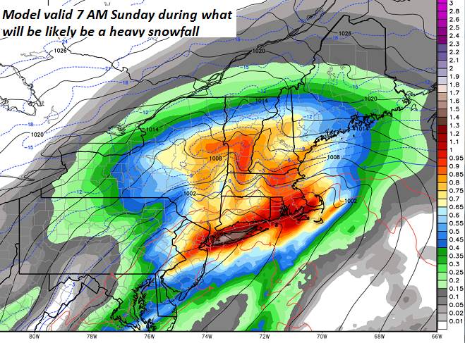
SUNDAY: Snow…moderate to heavy into the early afternoon. Significant accumulation likely 12 to 24”…otherwise cloudy and gray. A high in the mid-single digits northern areas to low teens toward Rutland.
Full Wolf Moon 12:16 AM Monday
MONDAY: Lots of clouds. Light snow with some minor additional accumulation with hints of sun and blustery and bitterly cold and dangerous wind chills possible. A low zero to 15 below. A high near zero degrees.
TUESDAY: Mostly sunny followed by high cloudiness in the afternoon. A low zero to 10 below. A high in the low teens.
WEDNESDAY: Clouding up. Chance for accumulating snowfall. A low single digits. A high in the 20s
Average lows single digits. Average highs in the 20s.
RH/1-17-19[end]
