Updated Monday Evening Forecast — February 10th, 2020

TONIGHT: A leftover flurry or sprinkle early northern areas this evening, otherwise lots of clouds. A low 20 to 25. Little wind.

TOMORROW: Cloudy. Scattered flurries or sprinkles. Little to no accumulation. A high 32 to 35. Light south winds.

TUESDAY NIGHT: Mainly cloudy. Chance for mountain snow showers or flurries after midnight, Accumulation dusting to an inch or two. A low in the mid-20s. West winds 10 to 20 mph.

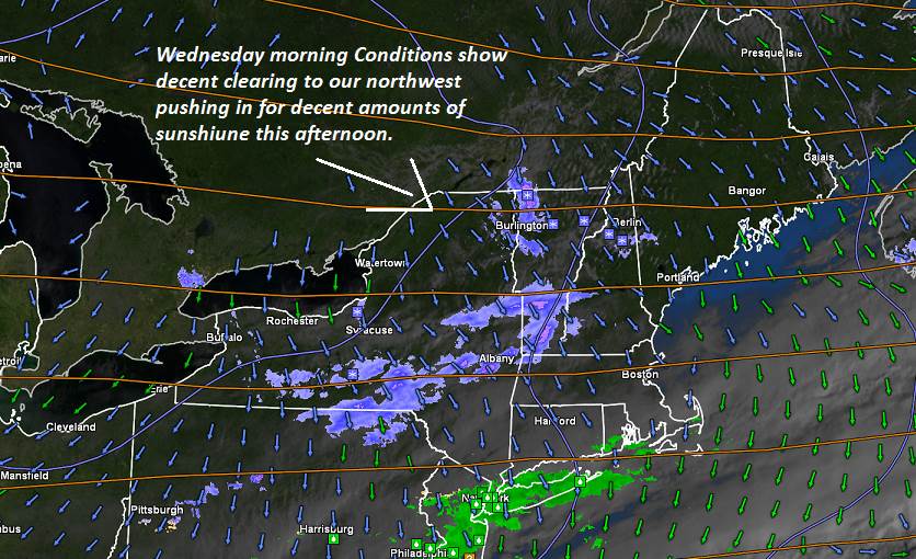
WEDNESDAY: Pick of the week. A few morning flurries exit to increasing sunshine. A high around 32 degrees. West winds 10 mph.

Looking further ahead…

WEDNESDAY NIGHT: Fair in the evening, then thickening clouds. A rising chance for light snow developing toward daybreak. A low in the mid-20s.

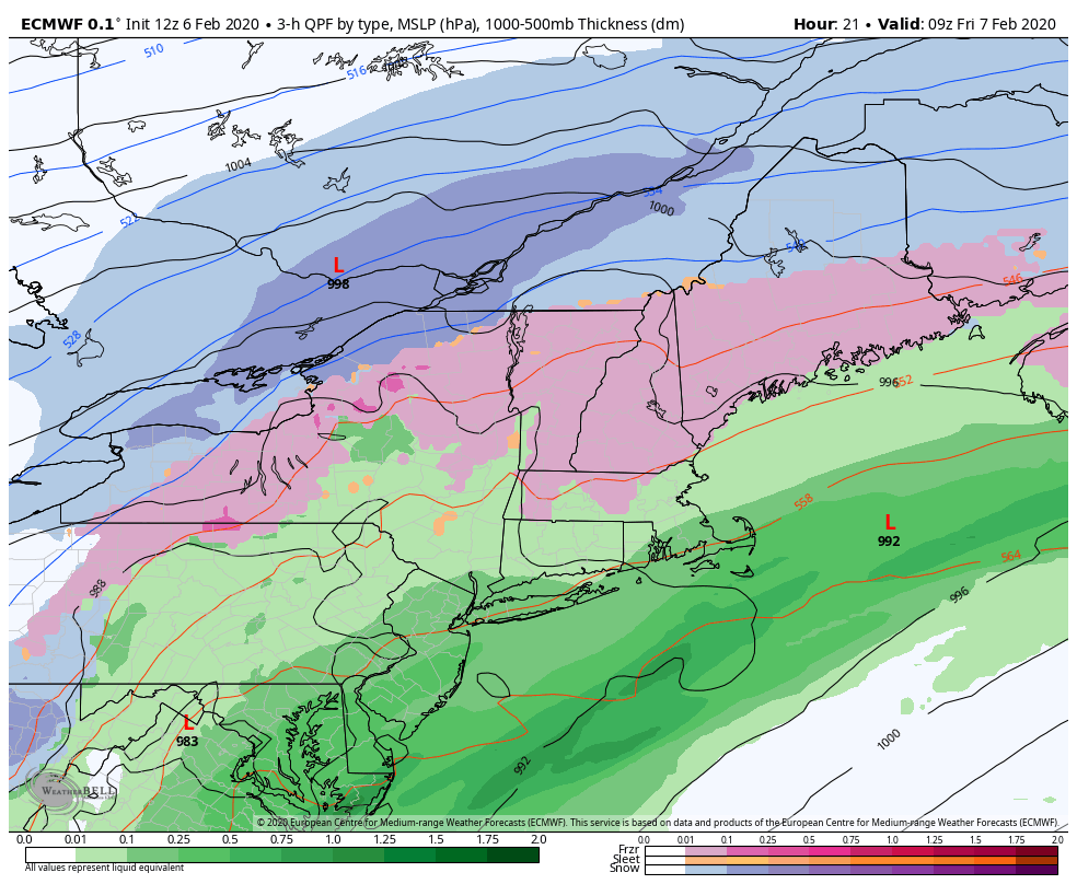
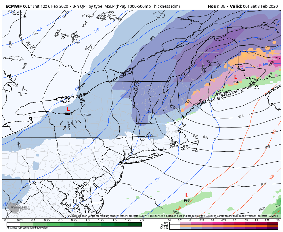
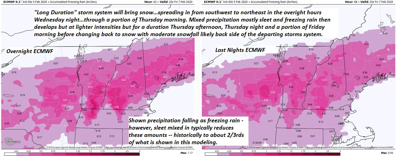
THURSDAY: Overcast. Good chance for snow…possibly moderate at times… transitioning to a wintry mix especially southern areas. A few to several inches of accumulation possible. A high 30 to 35.

FRIDAY: Scattered flurries and mountain snow showers in the morning Minor accumulation. Breaks of late day sunshine. Colder. A low zero to 10 degrees. A high in the mid-teens.

SATURDAY: Mostly sunny. Frigid. A low 10 to 20 below. A high in the low to mid teens.

Average lows upper single digits to mid-teens, average highs upper 20s to mid-30s.

RH/2-10[end]

Updated Monday Morning Forecast — February 10th, 2020

TODAY: Mainly gray, with possible break or two of sun. Occasional light snow showers gradually dry up this afternoon to few flurries or sprinkles. A high in the mid-30s. Light southwest winds.

TONIGHT: A leftover isolated flurry or sprinkle early, otherwise lots of clouds. A low in the low to mid 20s. Little wind.

TUESDAY: Cloudy. Chance for a few flurries toward southern Vermont. A high 32 to 35. Light south winds.

Looking further ahead…

TUESDAY NIGHT: Clouds gives way to partial clearing toward daybreak. Scattered flurries, but little accumulation. A low 20 to 25.

WEDNESDAY: Pick of the week. Filtered sunshine through high clouds. A high around 32 degrees.

THURSDAY: Overcast. Chance for snow…possibly moderate at times transitioning to a wintry mix late especially southern areas. A few to several inches of accumulation possible. A low 25 to 30. A high 30 to 35.

FRIDAY: Isolated flurries early, then increasing afternoon sunshine but colder. A low around 10. A high around 20.

Average lows upper single digits to mid teens, average highs upper 20s to mid-30s.

RH/2-10[end]

Updated Friday Evening Forecast — February 7th, 2020

Winter Storm Warning thru 10 PM this evening…

TONIGHT: Snow…winding down to flurries by mid evening. Additional accumulation of an inch or two. Otherwise, partially moonlit skies developing after midnight. Temperature falling into the single digits. Northwest wind 10 to 20 mph, with higher gusts causing blowing and drifting and lowering wind chills.

TOMORROW: Some clouds near the mountains with a few flurries, otherwise partly to mostly sunny. Cold. A high 10 to 15. Northwest winds 10 to 15 mph lowering wind chills.

Full snow Moon12:34 AM Sunday.

SATURDAY NIGHT: Clear and fully moonlit. Frigid. A low 10 to 20 below. Little wind.

SUNDAY: Sunshine gives way to increasing clouds in the afternoon. A high near 25. Light south winds.

Looking further ahead…

SUNDAY NIGHT: Considerable clouds. Chance for light flurries or mountains snow showers. Early low upper teens to around 20.

MONDAY: Mainly cloudy. Chance for light snow into the afternoon then drying up. An inch or two of accumulation. A high in the mid-30s.

TUESDAY: Mixed clouds and sun. Scattered flurries. A low 10 to 15. A high mid to upper 30s.

WEDNESDAY: Morning clouds then periods of afternoon sun. A low around 25. A high near 32.

Average lows 5 to 15 above, average highs mid-20s to mid-30s.

RH/2-7[end]

Updated Friday morning Forecast — February 7th, 2020

Winter Storm Warning thru 10 PM this evening…

TODAY: Gray. Wintry mix changing to snow…moderate to possibly heavy at times. Glazing up to two tenth of an inch central and southern Vermont. Snow accumulation 6 to 12”. A high near 32. Light north winds, becoming northwesterly 10 to 25 mph causing considerable blowing and drifting late this afternoon.

TONIGHT: Snow…briefly moderate…before winding down as flurries. Additional accumulation about 1 to 2”. Otherwise, mostly cloudy and sharply colder. A low in the single digits. Northwest wind 10 to 25 mph, with higher gusts causing blowing and drifting and lowering wind chills.

SATURDAY: Arctic-like sunshine. Diamond dust flurries in the morning. Cold. A high 10 to 15. Northwest winds 10 to 15 mph lowering wind chills.

Looking further ahead…

SATURDAY NIGHT: Frigid with a low 5 to 15 below with isolated spots near 20 below.

SUNDAY: Sunshine gives way to increasing clouds in the afternoon. A high 20 to 25.

MONDAY: Mainly cloudy. Chance for light snow into the afternoon then drying up. Early low upper teens to around 20. A high in the mid-30s.

TUESDAY: Mixed clouds and sun. Maybe a flurry. A low 15 to 20. A high around 35.

Average lows 5 to 15 above, average highs mid-20s to mid-30s.

RH/2-7[end]

Updated Thursday Evening Forecast – February 6th, 2020

Winter Storm Warning thru late Friday Evening…

TONIGHT: Overcast. Periods of sleet and freezing rain. Poor travel with sleet accumulation up to an inch…glazing up two tenths of an inch. A low 25 to 32. Wind becoming northeast 10 mph.

TOMORROW: Gray. Wintry mix continues thru early afternoon. Mixed precip changing to all snow…moderate at times. Snow accumulation about 4 to 8”. Temperatures in the upper 20s to near 32. Northeast winds 10 mph shifting to northwest 10 to 25 mph late causing considerable blowing and drifting.

FRIDAY NIGHT: Snow…moderate at times early in the evening…becoming lighter and winding down as snow showers and flurries. Additional accumulation about 1 to 3”. Otherwise, mostly cloudy. Sharply colder. A low zero to 5 above.

Northwest wind 10 to 20 mph with higher gusts causing blowing and drifting and lowering wind chills.

SATURDAY: Arctic-like sunshine. Diamond dust flurries in the morning. Bitterly cold with a high just 5 to 10 above. Northwest winds 10 to 15 mph lowering wind chills.

Looking further ahead…

SATURDAY NIGHT: Frigid with a low 5 to 15 below with isolated spots near 20 below.

SUNDAY: Sunshine gives way to increasing clouds in the afternoon. A high upper teens to mid-20s.

MONDAY: Mainly cloudy. Chance for light snow into the afternoon then drying up. Early lows in the teens then rising into the 20s. A high reaching mid to upper 30s late.

TUESDAY: Mixed clouds and sun. Maybe a flurry. A low 15 to 20. A high mid to upper 30s.

Average lows 5 to 15 above, average highs mid-20s to mid-30s.

RH/2-6[end]

Updated Thursday Morning Forecast — February 6th, 2020

Winter Storm Warning thru late Friday Evening…

TODAY: Gray, with accumulating snow…becoming lighter and occasional late morning into the afternoon…while mixing with sleet. A wintry mix across southern Vermont with glazing developing spreading northward late today reaching the Canadian border toward dark. About 3 to locally 6”accumulation by dark. Increasingly slick travel due snow coated roads and glazing southern areas this afternoon. A late day high near 30. Light southeast winds.

TONIGHT: Overcast. Wintry mix of freezing rain, sleet gradually changing back to snow northern areas. Treacherous travel due to ice accumulation up quarter inch. A low upper 20s. Wind becoming northeast 10 mph.

FRIDAY: Overcast. Wintry mix early…changing to all snow moderate to heavy at times. Significant snow accumulation likely. Temperatures 25 to 30. North winds 10 mph shifting to northwest 10 to 20 mph later on.

Looking further ahead…

FRIDAY NIGHT: Mostly cloudy. Periods of light snow or flurries winding down. Minor additional accumulation. Sharply colder with a low 5 to 10 above.

SATURDAY: Mostly sunny but cold. A high mid-teens to around 20.

SUNDAY: Sunshine gives way to increasing clouds in the afternoon with a chance for a flurries. A low zero to 10 below. A high upper teens to mid-20s.

Average lows 5 to 15 above, average highs mid-20s to mid-30s.

RH/2-6[end]

Updated Wednesday Evening Forecast — February 5th, 2020

Winter Storm Warning Early Thursday morning thru late Friday Evening…

TONIGHT: Fair this evening then clouding up. Accumulating snow developing in the pre-dawn hours affecting travel. A low 5 to 15 above. Light southeast winds.

TOMORROW: Cloudy. Periods of accumulating snow moderate at times…changing to a wintry mix of sleet and freezing rain late central and southern areas. About 2 to locally 5”accumulation Snow coated roads and some glazing with slick travel. A late day high about 30. Light southeast winds.

THURSDAY NIGHT: Overcast. Wintry mix of freezing rain and sleet gradually changing back to snow northern areas. Poor travel likely glazing. A low upper 20s. Wind becoming northeast 10 mph.

FRIDAY: Overcast. Wintry mix early…changing to all snow moderate to heavy at times. Significant snow accumulation likely. Temperatures 25 to 30. North winds 10 mph shifting to northwest 10 to 20 mph later on.

Looking further ahead…

FRIDAY NIGHT: Mostly cloudy. Periods of light snow or flurries winding down. Minor additional accumulation. Sharply colder with a low 5 to 10 above.

SATURDAY: Mostly sunny but cold. A high mid-teens to around 20.

SUNDAY: Sunshine gives way to increasing clouds in the afternoon with a chance for a flurries. A low zero to 10 below. A high upper teens to mid-20s.

Average lows 5 to 15 above, average highs mid-20s to mid-30s.

RH/2-5[end]

Updated Wednesday morning Forecast — February 5th, 2020

TODAY: Morning clouds with a few flurries, giving way to periods of afternoon sunshine, but colder. Temperatures holding or falling through the 20s. Northwest winds 10 to 15 mph.

Winter Storm Watch – Late Tonight thru Friday Evening…

TONIGHT: Thickening clouds. Accumulating snow developing toward morning affecting travel. A low 5 to 15 above, then temperatures rising. Light winds.

THURSDAY: Cloudy. Periods of accumulating snow moderate at times…changing to a wintry mix of sleet and freezing rain late central and southern areas. About 2 to locally 5”accumulation Snow coated roads and some glazing with slick travel. A late day high in the upper 20s. Light east winds.

Looking further ahead…

THURSDAY NIGHT: Overcast. Wintry mix of minor wet snow, sleet and freezing rain with poor travel. A low in the mid-20s.

FRIDAY: Overcast. Mixed precipitation…changing to snow moderate at times. Additional accumulation of about 3 to locally 6”possible. A high 25 to 30, but sharply colder Friday night.

SATURDAY: Leftover morning flurries dry up to partly to mostly sunny skies. A low in the single digits. A high mid-teens to around 20.

SUNDAY: Sunshine gives way to increasing clouds in the afternoon with a chance for a flurries. A low zero to 10 below. A high upper teens to mid-20s.

Average lows 5 to 15 above, average highs mid-20s to mid-30s.

RH/2-5[end]

Updated Tuesday Evening Forecast — February 4th, 2020

TONIGHT: Partly to mostly cloudy. A low 10 to 15. Northwest winds 10 mph

TOMORROW: Morning clouds with a spotty mountain flurry, giving way to periods of afternoon sunshine, but colder. A high 20 to 25. Northwest winds 10 to 15 mph.

WEDNESDAY NIGHT: Thickening clouds. Accumulating snow developing toward morning affecting travel. An early low in the single digits. Light winds.

THURSDAY: Cloudy. Periods of accumulating snow…changing to a wintry mix Barre-Montpelier area south…in the afternoon with slick travel and snow coated roads. About 3 to locally 6”possible. A late day high 25 to 30. Light east winds.

Looking further ahead…

THURSDAY NIGHT: Overcast. Periods of light accumulating snow north and mixed precipitation south. A low in the mid-20s.

FRIDAY: Overcast. Periods of accumulating snow north and mixed precipitation changing to snow…central and southern areas moderate at times with several inches possible. A high 25 to 30, but sharply colder Friday night.

SATURDAY: Leftover morning flurries dry up to increasing amounts of sunshine. A low in the single digits. A high mid-teens to around 20.

SUNDAY: Sunshine gives way to increasing high cloudiness. A low zero to 10 below. A high upper teens to mid 20s.

Average lows 5 to 15 above, average highs mid-20s to mid-30s.

RH/2-4[end]

Updated Tuesday morning Forecast — February 5th, 2020

TODAY: Clouds with a break or two of sun. Chance for a few flurries this afternoon. A high in the mid to upper 30s. Light southeast winds.

TONIGHT: Partly to mostly cloudy. A low in the teens. Northwest winds 10 mph

WEDNESDAY: Morning clouds giving way to periods of afternoon sunshine, but colder. A high 20 to 25. Northwest winds 10 to 15 mph.

Looking further ahead…

WEDNESDAY NIGHT: Thickening clouds. Accumulating snow likely toward morning affecting travel. A low in the single digits.

THURSDAY: Cloudy. Periods of accumulating snow likely…changing to a wintry mix in the afternoon with slippery travel. About 2 to locally 5”possible. A late day high near 30.

FRIDAY: Overcast. Good chance for periods of snow or mixed precip changing to snow moderate at times. Sharply colder. Temperatures falling from low to mid 30s…into the teens during the afternoon.

SATURDAY: Leftover morning flurries dry up to increasing amounts of sunshine. A low in the single digits. A high mid-teens to around 20.

SUNDAY: Sunshine gives way to increasing high cloudiness. A low zero to 10 below. A high upper teens to mid 20s.

Average lows 5 to 15 above, average highs mid-20s to mid-30s.

RH/2-3[end]