Updated Thursday Morning Forecast — April 23rd, 2020

TODAY: Bright sunshine and blue skies with some late day high clouds southern areas. A little warmer. A high mid-40s. Westerly breeze 10 to 15 mph.

TONIGHT: Thickening clouds. Chance for mixed rain and snow showers far southern areas late. A low upper 20s or around 30. Little wind.

FRIDAY: Mainly cloudy in the morning. Chance for leftover snow or rain showers southern areas exiting. Otherwise dry northern areas with hints of sunshine. A little warmer. A high 50 to 55 warmest central and northern areas. Light northeast winds.

Looking further ahead…

FRIDAY NIGHT: Clear. A low mid to upper 20s.

SATURDAY: Mostly sunny. High clouds southern areas late. Otherwise milder and pleasant. A high in the mid-50s.

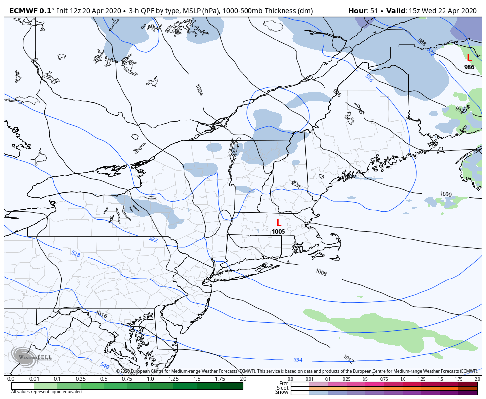
SUNDAY: Gray. Chance for rain valleys…and wet accumulating snow elevated terrain in the afternoon…continuing into Sunday night. A few inches snow accumulation high terrain. A low around 35. A high 40 to 45.

MONDAY: Mainly cloudy, with scattered rain and mountain snow showers exiting in the afternoon. A low near 35. A high in the 40s.

TUESDAY: Partly to mostly sunny. A low 25 to 30. A high 50 to 55.

Average lows ranging low to mid 30s, average highs in the mid-50s to near 60.

RH/4-23[end]

Updated Wednesday Evening Forecast — April 22nd, 2020

TONIGHT: Leftover flurries exit the Northeast Kingdom this evening. Otherwise clearing and cold. A low in the low to mid 20s. Northwest winds 10 to 25 mph for a time this evening gradually diminishes.

TOMORROW: Bright sunshine gives way to late day high cloudiness southern areas. A little warmer. A high mid-40s. Westerly breeze 10 to 15 mph.

THURSDAY NIGHT: Variable high cloudiness. A low 25 to 30. Little wind.

FRIDAY: High clouds with hints of sunshine. A little warmer. A high 50 to 55. Light northeast winds.

Looking further ahead…

FRIDAY NIGHT: Clear. A low around 25.

SATURDAY: Some high clouds but a decent amount of sunshine. A high 50 to 55.

SUNDAY: Lots of clouds. Chance for rain showers…mixed with wet snow high terrain central and southern Vermont. A low around 30. A high low 50s but cooler southern areas.

MONDAY: Morning sprinkles exit to more clouds then sun. A low near 35. A high 45 to 50.

Average lows ranging low to mid 30s, average highs in the mid-50s to near 60.

RH/4-22[end]

Updated Wednesday Morning Forecast — April 22nd, 2020

TODAY: Clouds with a break of sun now and then. Scattered flurries and few heavier mountain snow showers especially northern areas. Some additional minor accumulation at times especially this morning. Raw, Blustery to windy & raw. A high around 35…about 20 to 25 degrees below normal. West to northwest winds pick up 10 to 25 mph, localized gusts over 40 mph high terrain.

TONIGHT: Isolated evening flurries exit the Northeast Kingdom. Otherwise clearing and cold. A low in the low to mid 20s. Northwest winds 10 to 15 mph gradually diminishes.

THURSDAY: Bright sunshine gives way to late day high cloudiness. A little warmer. A high mid to upper 40s. Westerly breeze 10 to 15 mph.

Looking further ahead…

THURSDAY NIGHT: Variable cloudiness. A low 25 to 30.

FRIDAY: High cloudiness gives way to increasing sunshine and a little warmer. A high 50 to 55.

SATURDAY: Sunshine becoming filtered by high clouds. A low mid to upper 20s. A high in the lower 50s.

SUNDAY: Clouding up. Chance for rain showers…mixed with wet snow high terrain. A low near 32. A high in the mid-40s.

MONDAY: A period of morning sun, then partly cloudy. A low 32 to 35. A high 45 to 50.

Average lows ranging low to mid 30s, average highs in the mid-50s to near 60.

RH/4-22[end]

Updated Tuesday Evening Forecast — April 21st, 2020

TONIGHT: Becoming partly cloudy this evening, then more clouds overnight. Scattered mountain snow showers and valley flurries. A light coating of snow…the most Northeast Kingdom higher terrain. A low mid to upper 20s. Westerly winds 10 to 20 mph.

TOMORROW: Considerable cloudiness. Scattered mountain snow showers and valley flurries. Up to an inch accumulation high terrain. Blustery to windy and raw. A high around 35. West to northwest winds pick up 10 to 25 mph, gusts over 40 mph high terrain.

WEDNESDAY NIGHT: Isolated evening flurries exiting Northeast Kingdom. Otherwise clearing and cold. A low in the low to mid 20s. Northwest winds 10 to 15 mph gradually diminishes.

THURSDAY: Bright sunshine gives way to late day high cloudiness. A little warmer. A high mid to upper 40s. Westerly breeze 10 to 15 mph.

Looking further ahead…

THURSDAY NIGHT: Variable cloudiness. A low 25 to 30.

FRIDAY: High cloudiness gives way to increasing sunshine and a little warmer. A high upper 40s to around 50.

SATURDAY: Lots of sun filtered by high clouds. A low mid to upper 20s. A high in the low 50s.

SUNDAY: Clouding up. Chance for rain showers…mixed with wet snow higher terrain. A low near 32. A high in the mid-40s.

MONDAY: A period of morning sun, then partly cloudy. A low 32 to 35. A high 45 to 50.

Average lows ranging low to mid 30s, average highs in the mid-50s to near 60.

RH/4-21[end]

Updated Tuesday morning Forecast — April 21st, 2020

TODAY: Cloudy. Rain showers developing mid-day, briefly moderate at times eventually transitioning to wet snow especially the higher terrain late. Accumulation of an inch or so grassy surfaces Northeast Kingdom late. A high 45 to 50. South to southeast winds 10 to 25 mph with higher gusts, shifting to westerly late with a cold frontal passage.

TONIGHT: Partly to mostly cloudy. Widely scattered mountain snow showers and valley flurries. A dusting to an inch of accumulation with the most Northeast Kingdom higher terrain. A low mid to upper 20s. West to northwest winds 10 to 15 mph.

WEDNESDAY: Considerable cloudiness. Scattered mountain snow showers and valley flurries. Up to an inch accumulation higher terrain. Blustery to windy. A high mid to upper 30s. West to northwest winds pick up 10 to 25 mph, gusts over 40 mph high terrain.

Looking further ahead…

WEDNESDAY NIGHT: Isolated mountain flurries then clearing and colder. A low ranging thru the 20s.

THURSDAY: Bright sun and blue skies but still chilly. A high mid to upper 40s.

FRIDAY: High cloudiness gives way to increasing sunshine and a little warmer. A low 25 to 32. A high 50 to 55.

SATURDAY: Lots of sun filtered by high clouds. A low 25 to 30. A high 50 to 55.

Average lows ranging low to mid 30s, average highs in the mid-50s to near 60.

RH/4-21[end]

Updated Monday Evening forecast — April 20th, 2020

TONIGHT: Fair early then mostly cloudy. A low mid-20s to near 30. Light winds.

TOMORROW: Gray. A period of rain showers arrives toward mid-day mixing with or changing to a period of wet snow especially the higher terrain late. A high 45 to 50. South to southeast winds 10 to 25 mph with higher gusts, shifting to westerly late with a cold frontal passage.

TUESDAY NIGHT: Partly to mostly cloudy. Widely scattered mountain snow showers and valley flurries. A dusting to an inch of accumulation with the most Northeast Kingdom higher terrain. A low ranging thru the 20s. West to northwest winds 10 to 15 mph.

WEDNESDAY: More clouds than sun. Scattered mountain snow showers and valley flurries. Up to an inch accumulation northern higher terrain. Blustery to windy. A high mid to upper 30s. West to northwest winds pick up 10 to 25 mph, gusts over 40 mph high terrain.

Looking further ahead…

WEDNESDAY NIGHT: Mostly clear and very chilly. A low 20 to 25.

THURSDAY: Bright sun and blue skies but still chilly. A high mid to upper 40s.

FRIDAY: High cloudiness gives way to increasing sunshine and a little warmer. A low 25 to 32. A high 50 to 55.

SATURDAY: Lots of sun filtered by high clouds. A low 25 to 30. A high in the mid 50s.

Average lows ranging low to mid 30s, average highs in the mid-50s to near 60.

RH/4-20[end]

Updated Monday Morning Forecast — April 20th, 2020

TODAY: Partly to mostly sunny. A high in the mid to upper 40s. Light northwest winds.

TONIGHT: Fair early then mostly cloudy. A low around 30. Light winds.

TUESDAY: Gray. A round or rain showers becoming likely late morning on with wet snow flakes across the higher terrain later in the day before exiting. A high 45 to 50. South to southeast winds 10 to 25 mph with higher gusts across the hills.

Looking further ahead…

TUESDAY NIGHT: Partly to mostly cloudy. Chance for a few mountain snow flurries. A skiff of snow in some spots possible. A low in the mid-20s to near 30.

WEDNESDAY: More clouds than sun. Blustery to windy. A high mid to upper 30s.

THURSDAY: Pick of the week. Bright sunshine and blue skies. A low 25 to 30. A high upper 40s to around 50.

FRIDAY: Considerable high cloudiness in the morning, then mostly sunny in the afternoon. A low 25 to 32. A high 50 to 55.

Average lows ranging low to mid 30s, average highs in the mid-50s to near 60.

RH/4-20[end]

Updated Friday Evening forecast — April 17th, 2020

TONIGHT: Clouding up. Periods of light snow or flurries roughly Barre-Montpelier area south. A dusting to an inch in spots, up 2” far southern areas. A low in the upper 20s to low 30s. Light winds.

TOMORROW: Periods of light snow or flurries Barre-Montpelier area south… exiting in the morning. Accumulations dusting locally 4 inches near the Massachusetts border. Otherwise, intervals of afternoon sun develops northern areas. A high 40 to 45. Light east to northeast winds.

SATURDAY NIGHT: Becoming mostly clear. A low upper 20s to low 30s. Light south winds.

SUNDAY: Sunshine gives way to increasing clouds. Milder. Light rain showers Champlain Valley and northern areas arriving later in the afternoon. A high pushing 60. Southwest winds 10 to 20 mph.

Looking further ahead…

SUNDAY NIGHT: Fair with high cloudiness. A low 32 to 35.

MONDAY: High overcast with a few hints of sun. A high around 40.

TUESDAY: Gray. Rising chance for showers of rain mixed with wet snow in the higher terrain. A low mid to upper 20s. A high 40 to 45.

WEDNESDAY: Morning clouds, then partly to mostly sunny. Blustery to windy. A low mid to upper 20s. A high mid-30s to near 40.

Average lows ranging upper 20s to mid-30s, average highs in the mid to upper 50s.

RH/4-17[end]

Updated Friday morning Forecast — April 17th, 2020

TODAY: Brief periods of sunshine alternating with clouds before it clouds up late. Chance for more flurries across northern areas mid-day on.Becoming blustery. Continued chilly. A high around 40.Westerly winds 10 to occasionally 25 mph.

TONIGHT: Cloudy. Periods of light snow roughly Barre-Montpelier area south. A dusting to locally up to an inch central areas and an inch far southern higher terrain. A low in the upper 20s to low 30s. Light winds.

SATURDAY: Periods of light snow or snow showers southern areas exiting in the morning. Accumulations dusting to locally 3 inches near the Massachusetts border. Otherwise, clouds with intervals of afternoon sun develops central and northern areas. A high 40 to 45. Light east to northeast winds.

Looking further ahead…

SATURDAY NIGHT: Evening clouds then mostly clear. A low upper 20s to low 30s.

SUNDAY: Sunshine gives way to increasing clouds. Milder. A rising chance for light rain showers northern and western areas later in the afternoon. A high pushing 60.

MONDAY: High overcast with a few hints of sun. A low 32 to 35. A high around 40.

TUESDAY: Clouds with breaks of sun. Rising chance for showers of rain mixed with wet snow in the higher terrain. A low mid to upper 20s. A high 40 to 45.

WEDNESDAY: Morning clouds, then partly to mostly sunny. A low mid to upper 20s. A high mid-30s to near 40.

(Italics mean precip)

Average lows ranging upper 20s to mid-30s, average highs in the mid to upper 50s.

RH/4-17[end]

Updated Thursday Evening Forecast — April 16th, 2020

TONIGHT: Scattered clouds or mostly clear. A low mid to upper 20s. Light southwest winds.

TOMORROW: Brief morning sun, then considerable cloudiness. Chance of flurries across northern areas.Becoming blustery. Continued chilly. A high upper 30s to near 40.Westerly winds 10 to occasionally 25 mph.

FRIDAY NIGHT: Cloudy. Periods of light snow likely…southern areas. A dusting to an inch far southern higher terrain. A low in the upper 20s. Light winds.

SATURDAY: Periods of light snow or snow showers far south exiting. Accumulations up to locally 3” southern Greens. Otherwise, clouds with intervals of afternoon sun northern areas. A high in the low 40s. Light east to northeast winds.

Looking further ahead…

SATURDAY NIGHT: Mostly clear early then high clouds. A low upper 20s to low 30s.

SUNDAY: Morning sun, then more clouds. Milder. A rising chance for light rain showers northern and western areas later in the afternoon. A high around 55 to 60.

MONDAY: Partly sunny and cooler again. A low in the upper 20s. A high 45 to 50.

TUESDAY: Gray. Rising chance for periods of wet snow mixed with rain valley floors. A low around 25. A high 50 to 55.

(Italics mean precip)

Average lows ranging upper 20s to mid-30s, average highs in the mid to upper 50s.

RH/4-15[end]