Updated Monday Morning Forecast — August 3rd, 2020

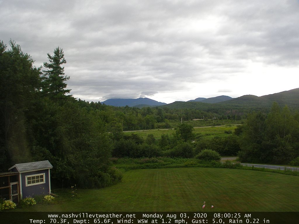
TODAY: Partly to mostly cloudy this morning & turning rather breezy. Slight chance for a shower far northern areas. Muggy this morning less humid this afternoon as clouds give way to more sunshine. A high near 80. Southwest breeze 10 to 20 mph shifting to westerly this afternoon.

TONIGHT: High cloudiness thickening up overnight leading to a chance for a few light showers overnight southern Vermont. A low in the lower 60s. Light winds.

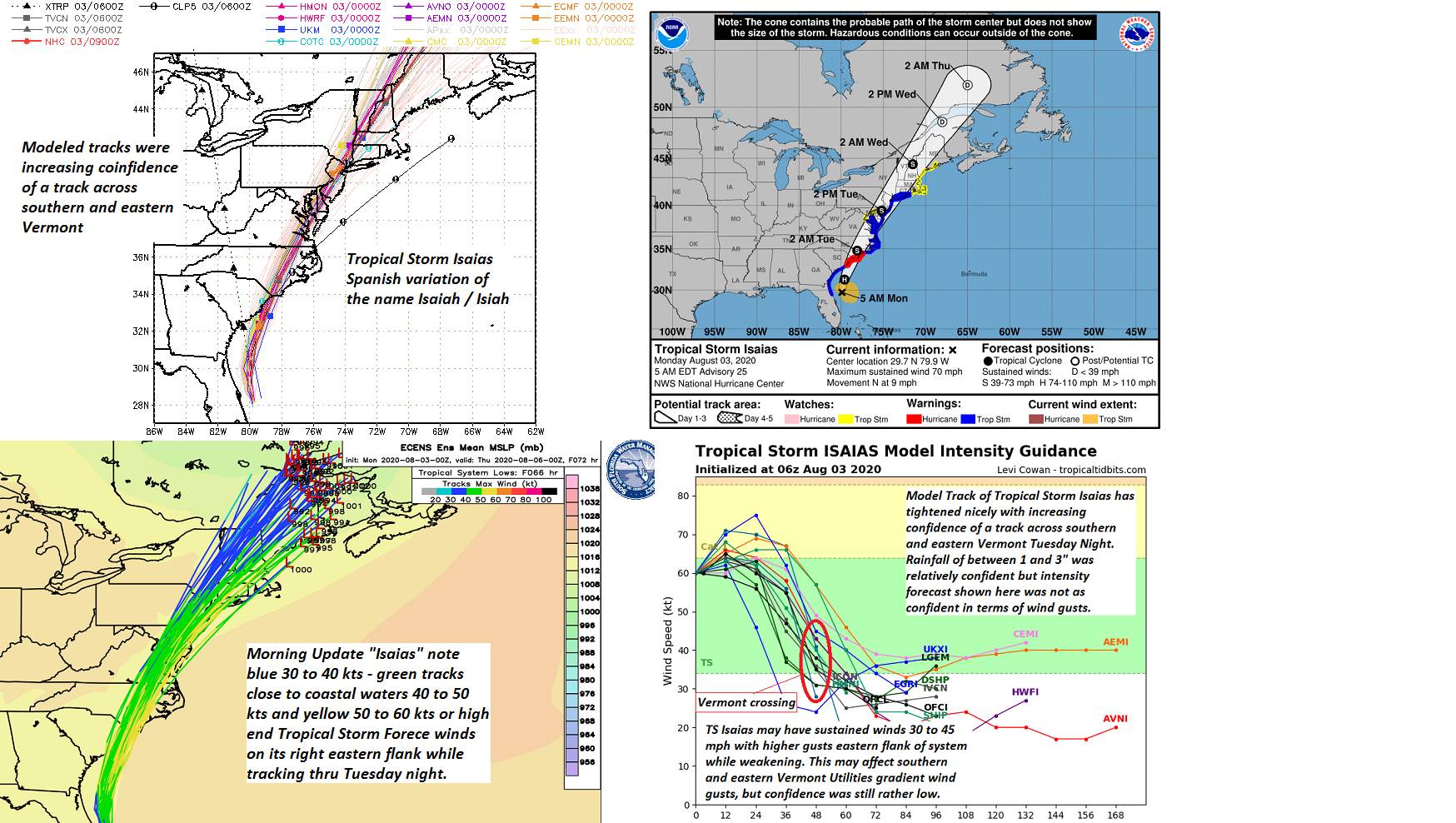
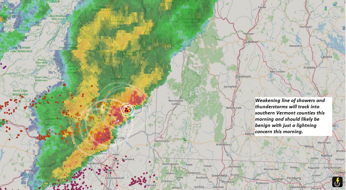
Flash Flood Watch in effect Tuesday afternoon into Wednesday morning…

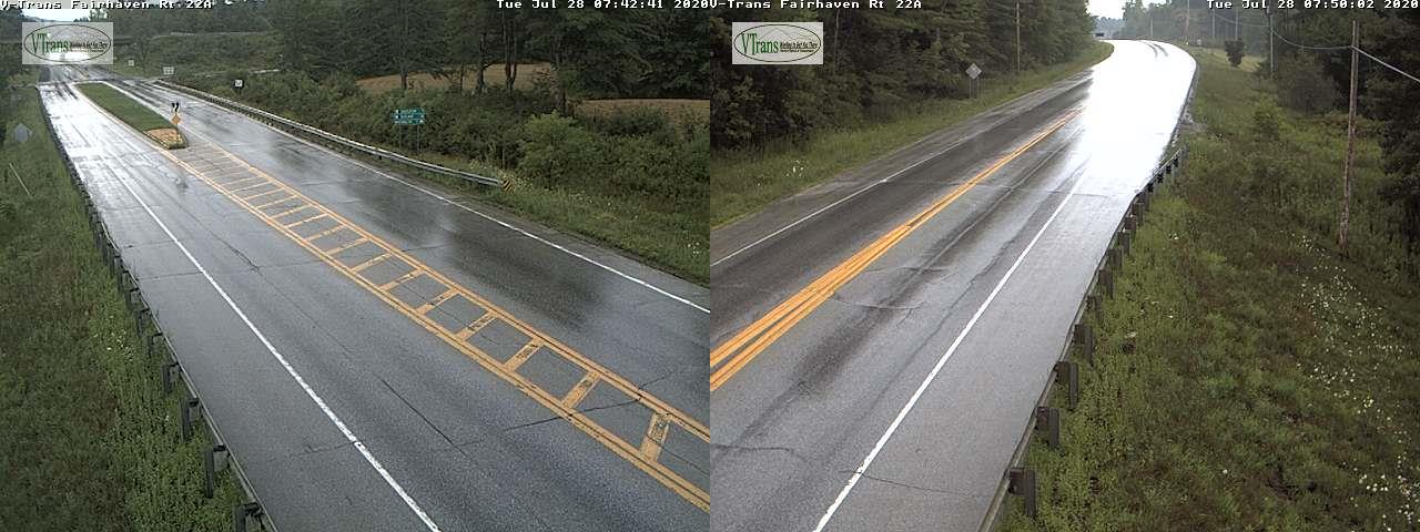
TUESDAY: Overcast and gray & rather muggy. Periods of soaking rain developing…moderate to heavy at times especially in the afternoon. A high around 75. Winds become southeasterly 10 mph.

Looking further ahead…

TUESDAY NIGHT: Overcast. Periods of rain…moderate to heavy at times with a chance for embedded thunderstorms. A low in the mid-60s.

WEDNESDAY: Early morning showers with a chance for thunder…moderate to heavy at times early, tapering to scattered showers, before drying up in the afternoon. A high in the mid-70s.

THURSDAY: Morning fog, then lots of sunshine with afternoon cloudiness. A low in the mid-50s. Cooler and less humid. A high in the 70 to 75.

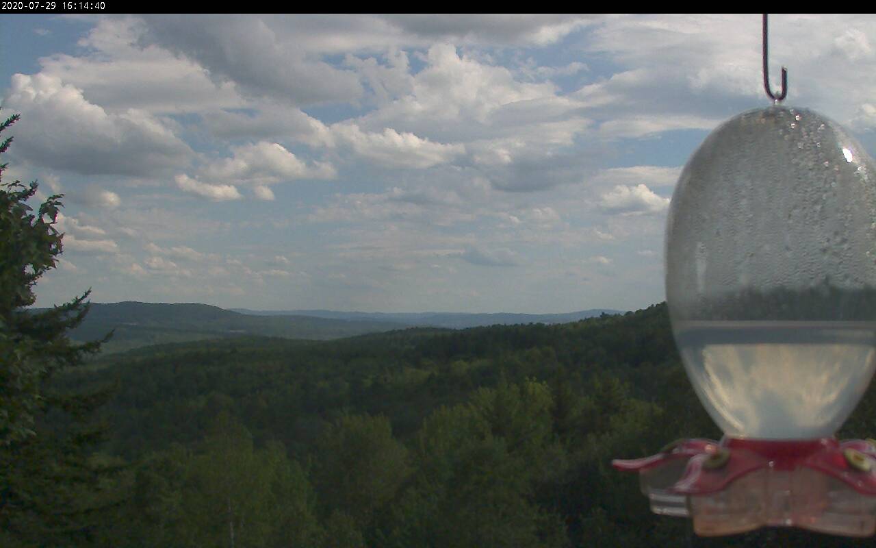
FRIDAY: Pick of the week. Mostly sunny with some high cloudiness. Pleasant. A low 50 to 55. A high in the mid-70s.

Average lows upper 50s to low 60s, average mid 70s to around 80.

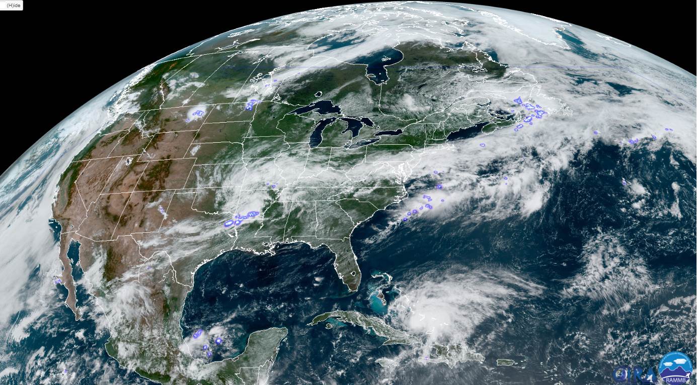
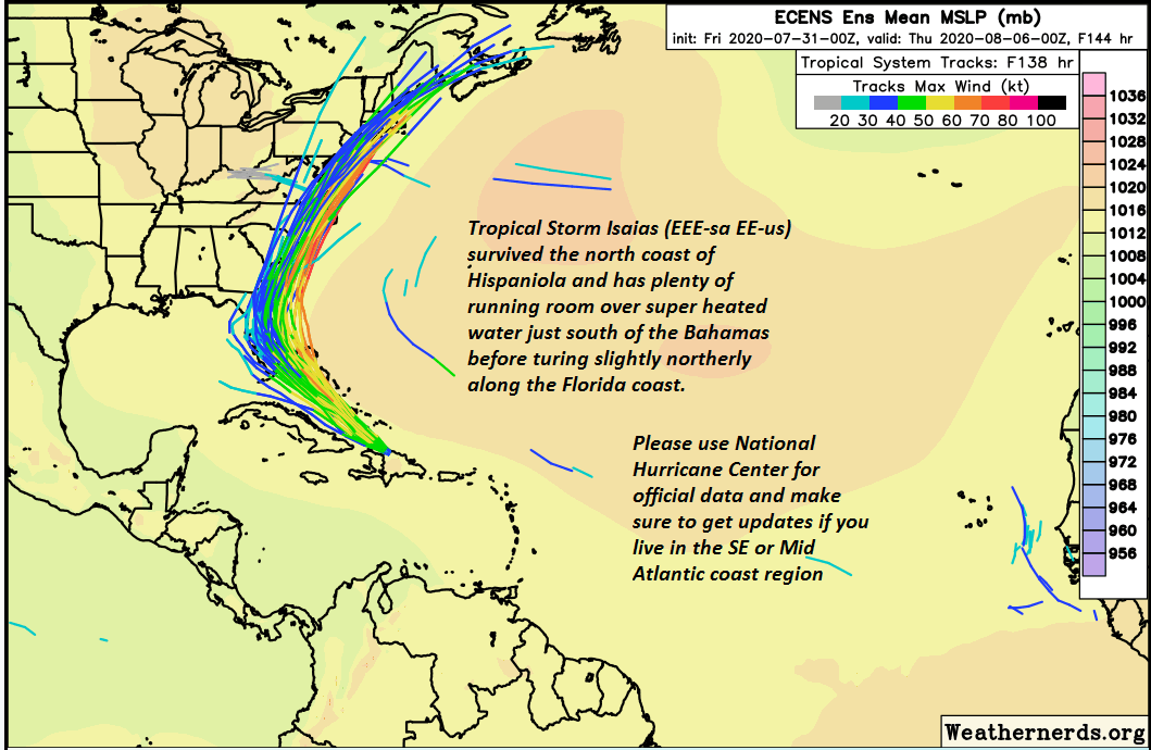
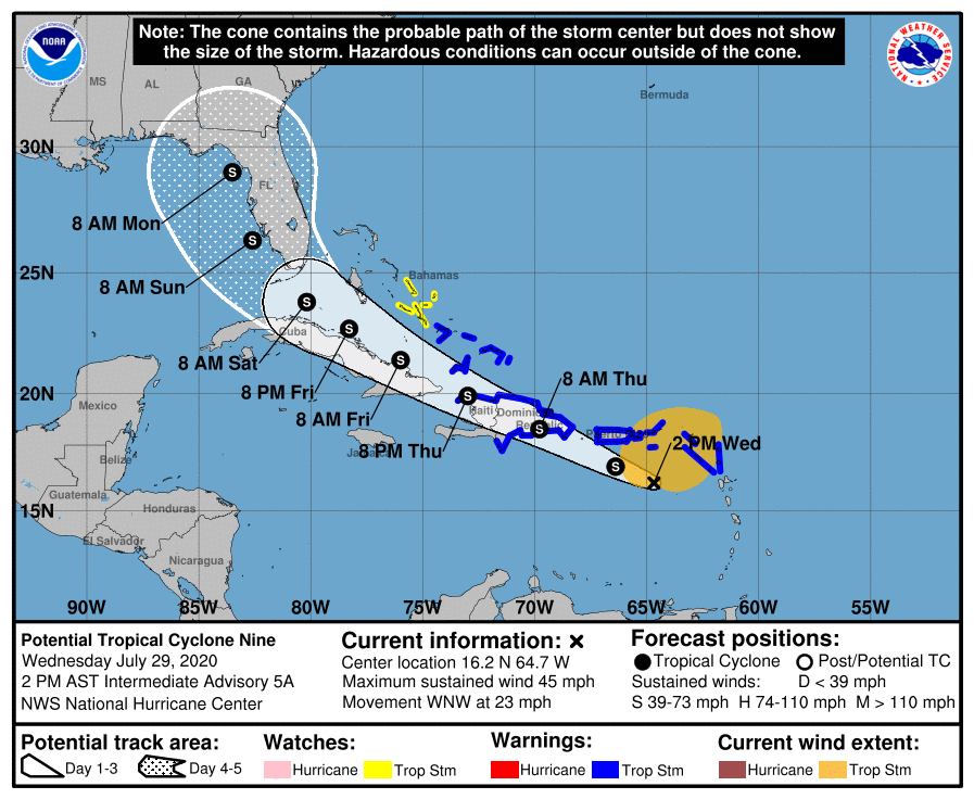
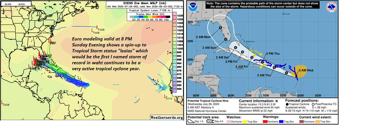
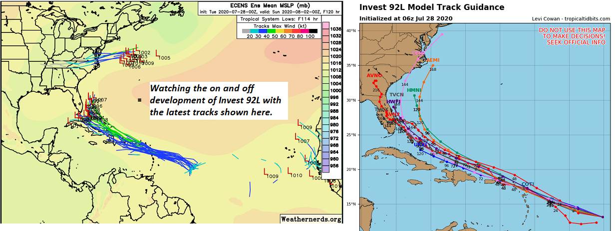
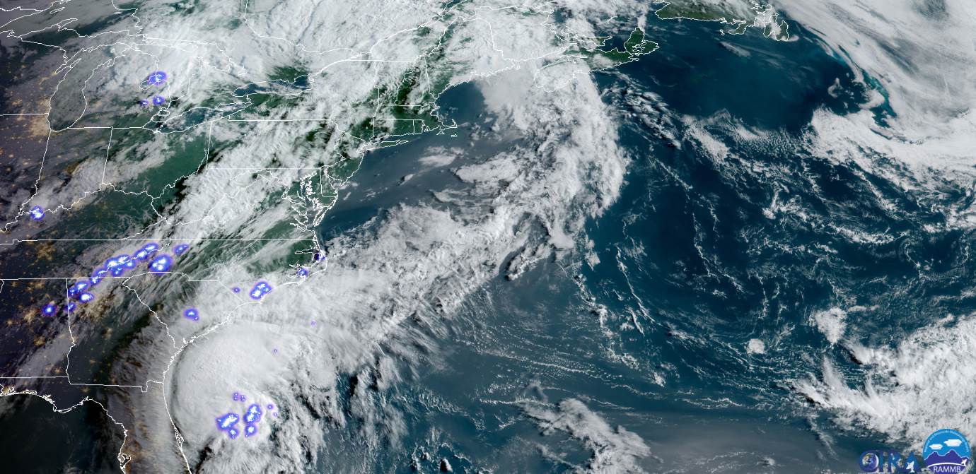
Tropical Storm Isaias (pronounced “EEE-sah-EE-us”)

RH/8-3[end]

Updated Friday Evening Forecast — July 31st 2020

TONIGHT: Mostly clear. Isolated valley fog. A low upper 50s to around 60. Light north wind.

TOMORROW: Sunshine filtered through high clouds. A high 80 to 85. Light northwest winds.

SATURDAY NIGHT: Mostly clear with high cloudiness. Isolated valley fog. A low around 60. Winds become east to southeast 10 mph.

SUNDAY: Filtered sunshine thru high clouds, thickening up in the afternoon. Widely scattered afternoon showers becoming more numerous late with a chance for thunder. A high near 85. Increasingly more humid late. South to southeast breeze 10 mph.

Looking further ahead…

SUNDAY NIGHT: Lots of clouds. Chance for showers and possible thunderstorms in the evening, then partial clearing overnight. Very muggy a low 65 to 70.

MONDAY: Isolated morning showers, then variable high cloudiness. Oppressively uncomfortable. A high in the mid-80s.

TUESDAY: Clouding up and sultry. Chance for showers or periods of rain…moderate to heavy at times with a risk of thunder. A low 60 to 65. A high in the mid-70s.

WEDNESDAY: Considerable cloudiness. Chance for showers or periods of rain…moderate to heavy at times with a risk of thunder. A low in the 60s. A high in the mid-70s.

Average lows upper 50s to low 60s, average upper 70s to around 80.

Hurricane Isaias (pronounced “EEE-sah-EE-us”)

RH/7-31[end]

Updated Friday Morning Forecast — July 31st, 2020

TODAY: Sunshine then afternoon clouds. Isolated afternoon shower threat Northeast Kingdom. A high upper 70s to around 80. Light northwest wind.

TONIGHT: Mostly clear. Isolated valley fog. A low upper 50s to around 60. Light north wind.

SATURDAY: Sunshine filtered through high clouds. A high 80 to 85. Light north to northwest winds.

Looking further ahead…

SATURDAY NIGHT: Mostly clear. Isolated valley fog. A low upper 50s to around 60.

SUNDAY: Filtered sunshine through high clouds, thickening up in the afternoon. Widely scattered afternoon showers becoming more numerous late with a chance for thunder. A high near 85. Increasingly more humid late.

MONDAY: Isolated morning showers, then partly to mostly sunny, later giving way to more clouds. Oppressively uncomfortable. Morning low mid-60s to near 70. A high in the mid-80s.

TUESDAY: Clouding up and sultry. *Chance for showers or periods of rain…moderate to heavy at times with a risk of thunder. A low 60 to 65. A high in the mid-70s.

WEDNESDAY: Considerable cloudiness. Chance for rain or showers with a risk of thunder. A low in the 60s. A high in the mid-70s.

Average lows upper 50s to low 60s, average upper 70s to around 80.

* TS. Isaias (pronounced “EEE-sah-EE-us”)

RH/7-31[end]

Updated Thursday Evening Forecast — July 30th, 2020

TONIGHT: Widely scattered showers with isolated rumbles of thunder northern areas dry up early this evening. Otherwise partly cloudy to mostly clear. Isolated valley fog. A low 55 to 60. Light northwest wind.

TOMORROW: Sunshine then afternoon clouds. Isolated afternoon shower threat Northeast Kingdom. A high upper 70s to around 80. Light northwest wind.

FRIDAY NIGHT: Mostly clear. Isolated valley fog. A low upper 50s to around 60. Light north wind.

SATURDAY: Sunshine filtered through high clouds. A high 80 to 85. Light north to northwest winds.

Looking further ahead…

SATURDAY NIGHT: Mostly clear. Isolated valley fog. A low upper 50s to around 60.

SUNDAY: Filtered sunshine through high clouds, thickening up in the afternoon. Widely scattered afternoon showers. A high near 85. Increasingly more humid late.

MONDAY: Sunshine, then afternoon clouds. Oppressively uncomfortable. Morning low mid-60s to near 70. A high in the mid-80s.

TUESDAY: Increasing clouds and sultry. *Chance for showers or periods of rain…moderate to heavy at times. A low 60 to 65. A high in the mid-70s.

Average lows upper 50s to low 60s, average upper 70s to around 80.

*Potential TS. Isaias (pronunciation “EEEsah-EEus”)

RH/7-30[end]

Updated Thursday Morning Forecast — July 30th, 2020

TODAY: Sunshine then afternoon clouds. Widely scattered afternoon pop-up showers with isolated rumbles of thunder especially Quebec border. A high upper 70s to around 80. West breeze 10 mph.

TONIGHT: Partly cloudy to mostly clear. A low 55 to 60. Little wind.

FRIDAY: Sunshine then afternoon clouds. A high upper 70s to around 80. Light northwest wind.

Looking further ahead…

FRIDAY NIGHT: Mostly clear. Isolated valley fog. A low upper 50s to around 60.

SATURDAY: Sunshine then more afternoon clouds. A high in the low 80s.

SUNDAY: Filtered sunshine through high clouds. A low 55 to 60. A high 80 to 85. Increasingly more humid late.

MONDAY: Sunshine, then afternoon clouds. Maybe a pop-up shower or storm. Oppressively uncomfortable. Morning low around 70. A high in the mid-80s to near 90.

Average lows upper 50s to low 60s, average upper 70s to around 80.

Potential TS. Isaias (pronunciation “ees-ah-EE-us”)

RH/7-30[end]

Updated Wednesday Evening Forecast — July 29th, 2020

TONIGHT: Widely scattered showers maybe a rumble of thunder toward the Champlain Valley flares up later this evening. Otherwise partly cloudy to mostly clear. A low in the low 60s. Light south winds.

TOMORROW: Sunshine then afternoon clouds. Widely scattered afternoon pop-up showers. A high upper 70s. West breeze 10 mph.

THURSDAY NIGHT: Partly cloudy to mostly clear. A low 55 to 60. Little wind.

FRIDAY: Sunshine then afternoon clouds. Isolated pop-up shower possible. A high upper 70s to around 80. Light northwest wind.

Looking further ahead…

FRIDAY NIGHT: Mostly clear. Isolated valley fog. A low upper 50s to around 60.

SATURDAY: Sunshine then more afternoon clouds. Widely scattered afternoon pop-up showers. A high in the low 80s.

SUNDAY: Filtered sun through high clouds early, then cloudy. A rising chance for showers in the afternoon with a risk of thunder. A low upper 50s to near 60. Increasingly more humid. A high in the low 80s.

MONDAY: Morning fog burns off to partial sunshine. Slight chance for a pop-up shower or storm. Oppressively uncomfortable. Morning low around 70. A high in the low to mid 80s.

Average lows low 60s, average highs around 80.

RH/7-29[end]

Updated Wednesday Morning forecast — July 29th, 2020

TODAY: Pick of the week. Lots of sunshine this morning then a few cloudy periods northern areas this afternoon. Maybe a brief shower or two northwestern Vermont. Comfortable and pleasant. A high 80 to 85. Southwest breeze 10 mph.

TONIGHT: Slight chance for a brief evening shower, maybe a rumble of thunder. Partly cloudy to mostly clear. A low in the low 60s. Light south winds.

THURSDAY: Sunshine then more afternoon clouds. Widely scattered afternoon pop-up showers. A high upper 70s.Light southwest winds.

Looking further ahead…

THURSDAY NIGHT: Partly cloudy to mostly clear. A low 55 to 60.

FRIDAY: Sunshine then more afternoon clouds. Isolated pop-up shower possible. A high upper 70s to around 80.

SATURDAY: Sunshine then more afternoon clouds. Widely scattered afternoon pop-up showers. A low around 60. A high around 80.

SUNDAY: Filtered sun through high clouds early, then cloudy. A rising chance for showers or a period of rain southern areas spreading northeast in the afternoon with a risk of thunder. A low 55 to 60. Increasingly more humid. A high near 80.

MONDAY: Morning fog burns off to partial sunshine. Slight chance for a pop-up shower or storm. Muggy to oppressive. Morning low mid-60s to near 70. A high upper 70s to around 80.

Average lows low 60s, average highs around 80.

RH/7-29[end]

Updated Tuesday Morning Forecast — July 28th, 2020

TONIGHT: Mostly clear. Much less humid with patchy valley fog. A low near 60. Light southwest winds.

TOMORROW: Pick of the week. Partly to mostly sunny with more clouds arriving late. Much more comfortable and pleasant. A high in the low 80s. Southwest breeze 10 mph.

WEDNESDAY NIGHT: Slight chance for a brief evening shower, maybe a rumble of thunder. Partly cloudy to mostly clear. A low in the low 60s. Light south winds.

THURSDAY: Sunshine then more afternoon clouds. Widely scattered afternoon pop-up showers. A high upper 70s.Light southwest winds.

Looking further ahead…

THURSDAY NIGHT: Partly cloudy to mostly clear. A low 55 to 60.

FRIDAY: Sunshine then more afternoon clouds. Isolated pop-up shower possible. A high mid to upper 70s.

SATURDAY: Sunshine then more afternoon clouds. Widely scattered afternoon pop-up showers. A low around 60. A high around 80.

SUNDAY: Filtered sun through high clouds thickening up late. A rising chance for showers or a period of rain southern areas spreading northeast late with a risk of thunder. A low 55 to 60. A high in the mid-80s.

Average lows low 60s, average highs around 80.

RH/7-28[end]

Updated Tuesday Morning Forecast — July 28th, 2020

TODAY: Warm and oppressive with increasing clouds this morning. Isolated to widely scattered brief showers thru mid-day. Maybe a rumble of thunder. Becoming partly to mostly sunny & turning less humid this afternoon. A high near 85. Light southwest breeze.

TONIGHT: Mostly clear. Much less humid with patchy valley fog. A low near 60. Light southwest winds.

WEDNESDAY: Pick of the week. Partly to mostly sunny with more clouds arriving late. Much more comfortable and pleasant. A high 80 to 85. Southwest breeze 10 mph.

Looking further ahead…

WEDNESDAY NIGHT: Slight chance for a brief shower northern areas in the evening. Partly cloudy to mostly clear. A low in the low 60s.

THURSDAY: Sunshine then more afternoon clouds. Slight chance for an afternoon pop-up shower. A high upper 70s to near 80.

FRIDAY: Sunshine then more afternoon clouds. Slight chance for an afternoon pop-up shower. A low 55 to 60. A high 75 to 80.

SATURDAY: Sunshine then more afternoon clouds. Slight chance for an afternoon pop-up shower. A low around 60. A high around 80.

SUNDAY: Filtered sun through high clouds thickening up late, with a chance for showers late. A low around 60. A high in the mid-80s.

Average lows low 60s, average highs around 80.

RH/7-28[end]

Updated Monday Evening Forecast — July 27th, 2020

Heat Index shown for temperature at 4:15 PM

Heat Advisories S. Champlain Valley and lower valleys Windsor County early this evening…

TONIGHT: A few showers and isolated thunderstorms…possibly strong across northern areas winding down, otherwise becoming mostly clear. Remaining warm and oppressive. A low upper 60s to near 70. Light southwest winds.

TOMORROW: A round showers and thunderstorms, some briefly strong with locally heavy downpours mid-morning thru early afternoon then exiting. Becoming partly to mostly sunny turning less humid. A high around 85. Light southwest breeze.

TUESDAY NIGHT: Becoming mostly clear with a few high clouds. Considerable valley fog. Much less humid. A low 55 to 60. Light southwest winds.

WEDNESDAY: Pick of the week. Partly to mostly sunny with more clouds arriving late. Much more comfortable and pleasant. A high 80 to 85. Southwest breeze 10 mph.

Looking further ahead…

WEDNESDAY NIGHT: Slight chance for a brief shower northern areas in the evening. Partly cloudy to mostly clear. A low in the low 60s.

THURSDAY: Partly sunny. Chance for an afternoon pop-up shower or thunderstorm. A high upper 70s to near 80.

FRIDAY: Partly sunny. Chance for an afternoon pop-up shower or thunderstorm. A low 55 to 60. A high 75 to 80.

SATURDAY: Mixed clouds and sun. A low around 60. A high around 80.

Average lows low 60s, average highs around 80.