Updated Friday Evening Forecast — August 28th, 2020

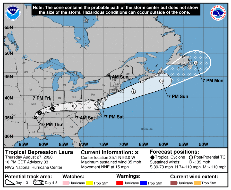
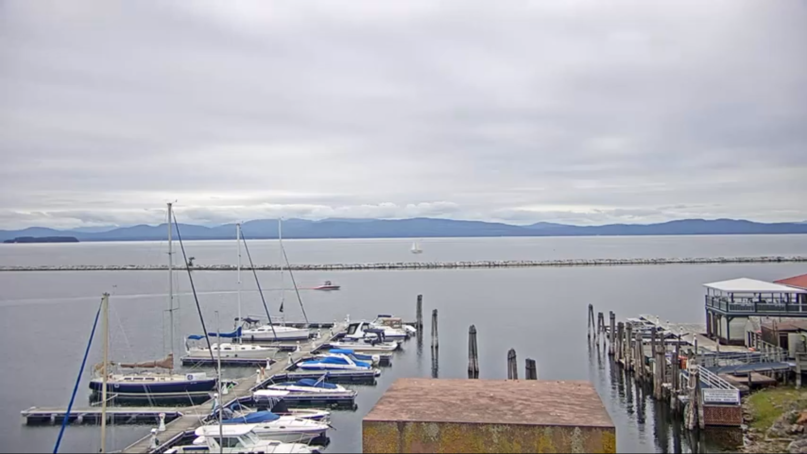
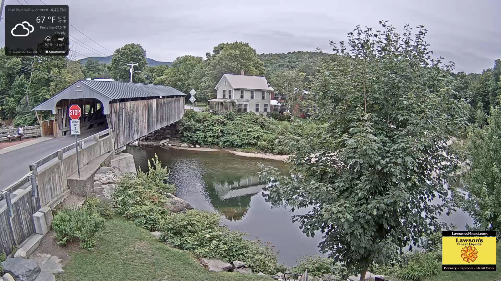
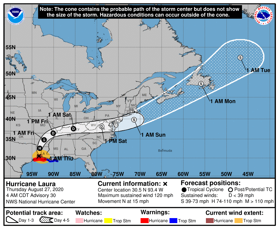
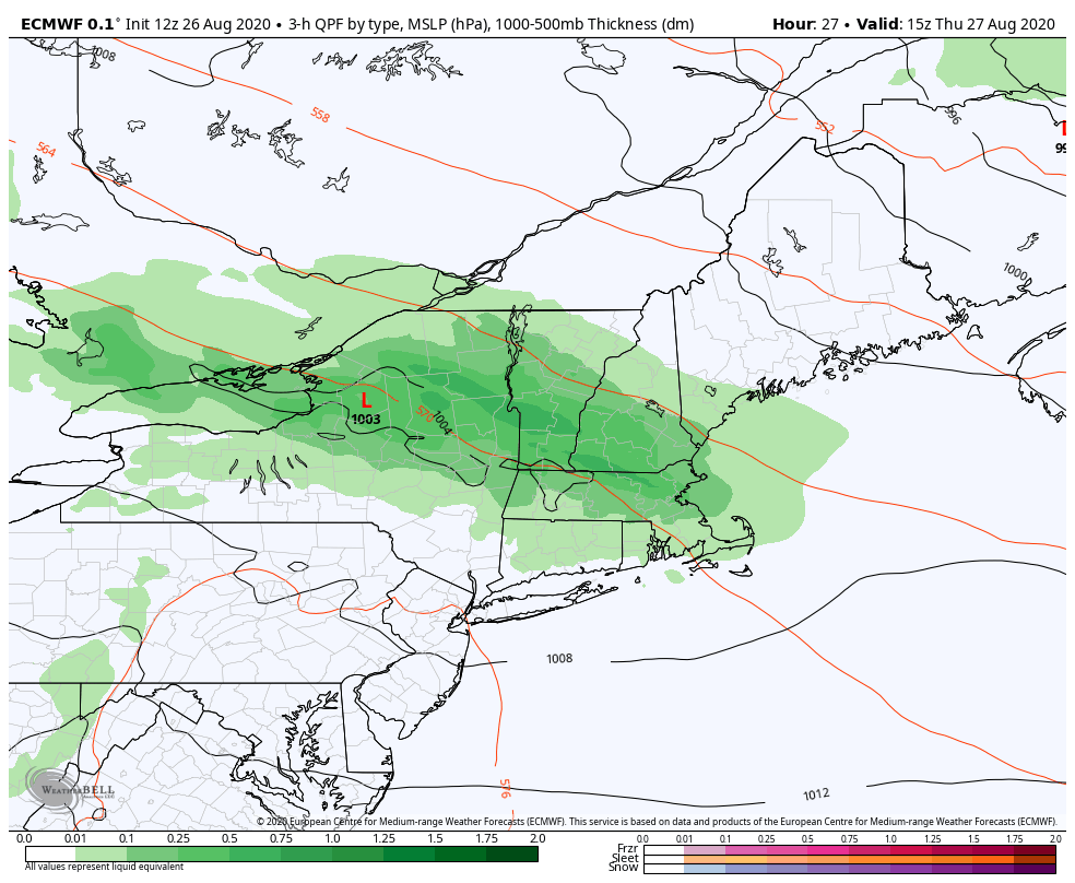
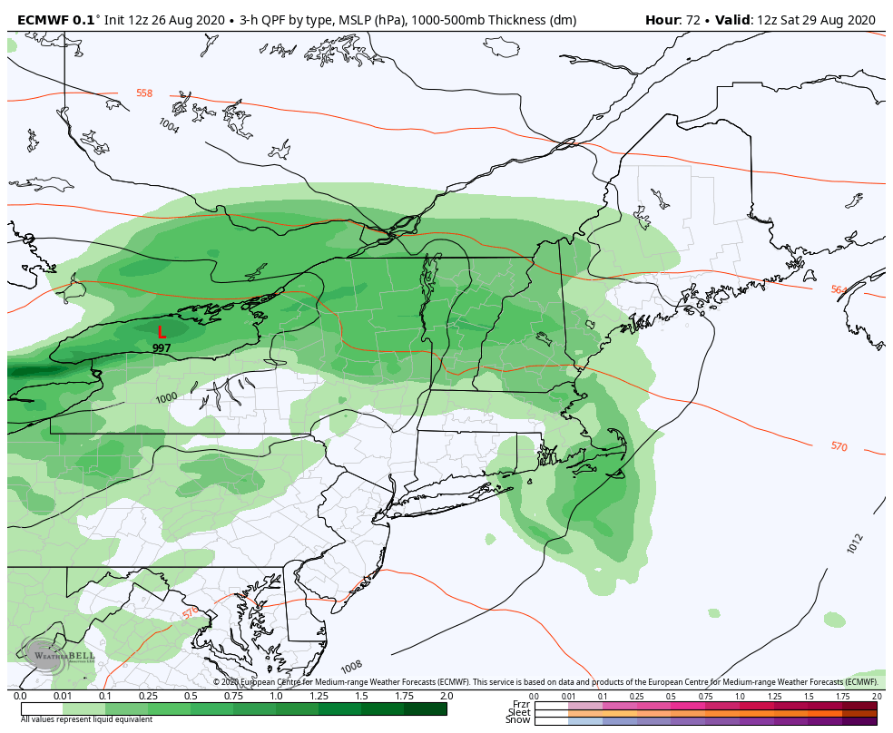
TONIGHT: Clouding up. Showers likely toward day break. A low near 55. Light winds.

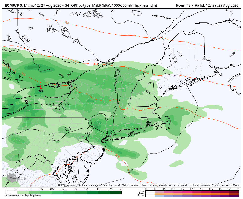
TOMORROW: Gray. Showers likely with embedded thunderstorms…especially mid to late afternoon. One or storms may become strong western and southern areas. A high in the low 70s. South to southeast breeze 10 mph.

SATURDAY NIGHT: Lots of clouds. A chance for lingering showers. A low in the mid-50s. Southwest winds 10 to 20 mph becoming northwesterly overnight.

SUNDAY: Slight chance for a shower, otherwise lots of clouds giving way to intervals of afternoon sun. Cool. A high in the mid-60s. Northwest winds 10 to 20 mph.

Looking further ahead…

SUNDAY NIGHT: Evening clouds then mostly clear. Patchy valley fog. Chilly. A low around 45

MONDAY: Morning fog burns off to lots of sunshine. A high near 65.

TUESDAY: Morning fog, then thickening clouds. A low 45 to 50. A high around 70.

WEDNESDAY: Variably cloudy. Chance for showers and possible thunderstorms. A low in the mid-50s. A high near 75.

Average lows 50 to 55, average highs ranging in the mid-70s.

RH/8-28[end]

Updated Friday Morning forecast — August 28th, 2020

TODAY: Morning clouds giving way to partial afternoon sunshine. A high around 70. Northwest breeze 10 mph.

TONIGHT: Clouding up. Showers likely toward day break. A low 50 to 55. Light winds.

SATURDAY: Gray. Showers likely with embedded thunderstorms…especially mid to late afternoon. Cool. A high 65 to 70. Southeast breeze 10 mph.

Looking further ahead…

SATURDAY NIGHT: Lots of clouds. A chance for lingering showers. A low in the mid-50s.

SUNDAY: Slight chance for a shower, otherwise lots of clouds giving way to intervals of afternoon sun. Cool. A high in the mid-60s.

MONDAY: Morning fog burns off to lots of sunshine. A low around 45. A high near 65.

TUESDAY: Morning fog, then thickening high cloudiness. A low around 45. A high around 70.

WEDNESDAY: Mostly cloudy. Chance for showers and possible thunderstorms. A low in the mid-50s. A high 70 to 75.

Average lows 50 to 55, average highs ranging in the mid-70s.

RH/8-28[end]

Updated Thursday Evening Forecast — August 27th, 2020

TONIGHT: Mostly cloudy patchy valley fog. A low around 50. Light winds.

TOMORROW: Morning clouds giving way to partial afternoon sunshine. A high around 70. Northwest breeze 10 mph.

FRIDAY NIGHT: Clouding up. Showers likely after midnight. A low 50 to 55. Light winds.

SATURDAY: Gray skies. Showers likely with embedded thunderstorms…especially southern areas in the afternoon. Cool. A high near 65. Southeast breeze 10 mph.

Looking further ahead…

SATURDAY NIGHT: A chance for lingering showers then mostly clear overnight. A low in the mid-50s.

SUNDAY: Fog gives way partly sunny skies. A high in the mid to upper 60s.

MONDAY: Morning fog then mostly sunny. A low around 45. A high 60 to 65.

TUESDAY: Morning fog, then filtered sunshine through high clouds. A low around 45. A high around 70.

WEDNESDAY: Mostly cloudy. Chance for showers and possible thunderstorms. A low in the mid-50s. A high mid-70s.

Average lows 50 to 55, average highs ranging in the mid-70s.

RH/8-27[end]

Updated Thursday Morning forecast — August 27th, 2020

TODAY: Becoming mostly cloudy. Showers…developing this morning Addison to Windsor county and points south. Intervals of sun developing northern areas this afternoon. Cool with a high around 65. Light variable winds.

TONIGHT: Partly cloudy. Considerable valley fog. A low around 50. Light winds.

FRIDAY: Clouds mixed with periods of sun. A high in the low 70s. Light west winds.

Looking further ahead…

FRIDAY NIGHT: Becoming mainly cloudy. Chance for showers developing late. A low 50 to 55.

SATURDAY: Overcast. Chance of showers & maybe rumble of thunder. A high around 70.

SUNDAY: Fog gives way partly to mostly sunny skies. A low in the mid-50s. A high in the upper 60s.

MONDAY: Morning fog then partly sunny. A low upper 40s. A high 60 to 65.

TUESDAY: Morning fog, then sunshine becoming filtered by high cloudiness. A low around 45. A high 70 to 75.

WEDNESDAY: Mostly cloudy. Scattered showers developing. A low in the mid-50s. A high near 75.

Average lows 50 to 55, average highs ranging in the mid-70s.

RH/8-27[end]

Updated Wednesday Evening Forecast — August 26th, 2020

TONIGHT: Mostly clear this evening, then increasing & thickening cloudiness. A low mid to upper 40s. Light west winds.

TOMORROW: Cloudy. Showers…moderate at times…central and southern areas especially outside NE. Kingdom through early afternoon. Intervals of sun developing in the afternoon. Cool with a high around 65. Light variable winds.

THURSDAY NIGHT: Partly cloudy. Considerable valley fog. A low in the low 50s. Light winds.

FRIDAY: Clouds mixed with periods of sun. Maybe an early mountain sprinkle. A high in the low 70s. Light west winds.

Looking further ahead…

FRIDAY NIGHT: Becoming mainly cloudy. Chance for showers developing late. A low around 55.

SATURDAY: Overcast. Chance of showers & maybe rumble of thunder. A high near 70.

SUNDAY: Fog gives way to mixed sun and & clouds. A low in the mid-50s. A high in the upper 60s.

MONDAY: Morning fog then mostly sunny. A low upper 40s to around 50. A high around 65.

TUESDAY: Morning fog, then sunshine becoming filtered by high cloudiness. A low around 45. A high 70 to 75.

Average lows 50 to 55, average highs ranging in the mid-70s.

RH/8-26[end]

Updated Wednesday morning Forecast — August 26th, 2020

TODAY: A few morning clouds, gives way to mostly sunny skies. Rather cool – a touch of autumn. A high 60 to 65. Northwest breeze 10 to 15 mph.

TONIGHT: Clear for a time then increasing and thickening clouds. A low mid to upper 40s. Light west winds.

THURSDAY: Overcast and gray. Showers…moderate at times especially southern and western areas with a risk of few isolated thunderstorms. Remaining chilly. A high 60 to 65. Light south to southeast winds.

Looking further ahead…

THURSDAY NIGHT: A few leftover showers, otherwise partly to mostly cloudy. Isolated valley fog. A low around 55.

FRIDAY: Clouds mixed with intervals of sun. Maybe an early mountain sprinkle. A high in the low 70s

SATURDAY: Overcast. Chance of showers & possible afternoon thunderstorms. A low in the mid-50s. A high low 70s.

SUNDAY: Morning fog & low cloudiness then partial afternoon sunshine. A low in the mid-50s. A high in the in the upper 60s to near 70.

MONDAY: Morning fog then mostly sunny. A low upper 40s to around 50. A high in the mid-60s.

TUESDAY: Morning fog, then sunshine becoming filtered by high cloudiness. A low in the 40s. A high in the low to mid 70s.

Average lows 50 to 55, average highs ranging in the mid-70s.

RH/8-26[end]

Updated Tuesday Evening Forecast — August 25th, 2020

TONIGHT: A few evening clouds otherwise mostly clear. Isolated valley fog. Much cooler and less humid. A low around 50. Northwest winds 10 mph.

TOMORROW: Morning fog, gives way to mostly sunny skies. Rather cool – a touch of autumn. A high 60 to 65. Northwest breeze 10 to 15 mph.

WEDNESDAY NIGHT: Clear for a time then increasing and thickening clouds. A low mid to upper 40s. Light west winds.

THURSDAY: Overcast and gray. Good chance for showers…moderate at times with a thunderstorm or two western and southern areas. On the cool side. A high 60 to 65. Light south to southeast winds.

Looking further ahead…

THURSDAY NIGHT: A few leftover showers, otherwise partly to mostly cloudy. A low around 55.

FRIDAY: Clouds mixed with intervals of sun. A high in the low 70s

SATURDAY: Mainly cloudy. Chance of showers and few afternoon thunderstorms. A low in the mid-50s. A high low 70s.

SUNDAY: Morning fog and then lots of sunshine. A low in the mid-50s. A high in the in the upper 60s to near 70.

Average lows 50 to 55, average highs ranging in the mid-70s.

RH/8-25[end]

Updated Tuesday Morning Weather — August 25th, 2020

TODAY: Clouds mixed with intervals of sun and humid. Hit and miss showers & thunderstorms, one or two possibly strong especially eastern and southern areas late morning to mid-afternoon. A high near75. Winds becoming northwesterly 10 to 20 mph this afternoon.

TONIGHT: A few evening clouds otherwise mostly clear. Isolated valley fog. Much cooler and less humid. A low around 50. Northwest winds 10 mph.

WEDNESDAY: Morning fog, gives way to mostly sunny skies. Below normal in temperature with a touch of autumn. A high 60 to 65. Northwest breeze 10 to 15 mph.

Looking further ahead…

WEDNESDAY NIGHT: Clear for a time then increasing and thickening clouds. A low mid-40s to around 50.

THURSDAY: Cloudy. Chance for intermittent rain or showers, moderate at times. Maybe a thunderstorm far southern areas. A high 60 to 65.

FRIDAY: More clouds than sun. A low around 50. A high 70 to 75.

SATURDAY: Considerable cloudiness. Chance of showers and possible thunderstorms. A low in the mid-50s. A high around 70.

SUNDAY: Morning fog and then partly sunny skies. A low in the mid-50s. A high in the in the upper 60s to near 70.

Average lows 50 to 55, average highs ranging in the mid-70s.

RH/8-25[end]

Updated Monday Evening Forecast — August 24th, 2020

TONIGHT: Variable cloudiness. An isolated shower or storm this early, then again overnight. Warm and uncomfortably humid. A low mid-60s to near 70. Light south winds.

TOMORROW: Clouds mixed with sun. Rather humid. Hit and miss showers & thunderstorms one or two possibly strong. A high around 75. Winds becoming northwesterly 10 to 15 mph.

TUESDAY NIGHT: Evening clouds then clearing. Patchy valley fog. Much cooler and less humid. A low around 50. Northwest winds 10 mph.

WEDNESDAY: Morning fog, gives way to bright sunshine and blue skies. Below normal in temperature with a touch of autumn. A high in the low to mid 60s. Northwest breeze 10 to 15 mph.

Looking further ahead…

WEDNESDAY NIGHT: Mostly clear in the evening, then thickening high clouds. A low mid-40s to around 50.

THURSDAY: Variable high cloudiness north, with clouds & the chance for showers southern areas. Still cool. A high in the mid-60s.

FRIDAY: More clouds than sun. A low around 50. A high near 70.

SATURDAY: Considerable cloudiness with chance for showers & possible thunderstorms. A low in the mid-50s. A high in the mid-70s.

Average lows 50 to 55, average highs ranging in the mid-70s.

RH/8-24[end]

Updated Monday Morning Forecast — August 24th, 2020

TODAY: Clouds northern areas this morning, otherwise becoming partly to mostly sunny. Isolated to widely scattered hit and miss showers and thunderstorms mid to late afternoon…possibly with gusty winds and heavy downpours. Warm & muggy with a high in the low to mid 80s. Southwest breeze 10 mph.

TONIGHT: Variable cloudiness. An isolated shower or storm this early, then again overnight. Warm and uncomfortably humid. A low mid-60s to near 70. Light southwest winds.

TUESDAY: Clouds mixed with sun. Rather humid. Hit and miss showers & thunderstorms one or two possibly strong. A high around 75. Southwest winds shift to northwesterly 10 to 15 mph.

Looking further ahead…

TUESDAY NIGHT: Evening clouds then clearing. Patchy valley fog. Much cooler and less humid. A low upper 40s to around 50.

WEDNESDAY: Morning fog, gives way to bright sunshine and blue skies. Below normal in temperature with a touch of autumn. A high around 65.

THURSDAY: Sunshine, becoming filtered through high cloudiness. Still rather cool. A low around 45. A high 65 to 70.

FRIDAY: Becoming partly to mostly cloudy. A low around 50. A high mid-70s to near 80.

Average lows 50 to 55, average highs ranging in the mid-70s.

RH/8-24[end]