Updated Friday Morning forecast — March 26th, 2021

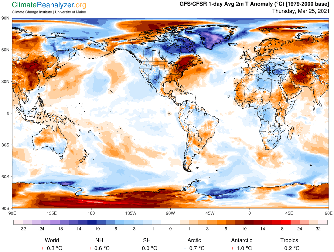
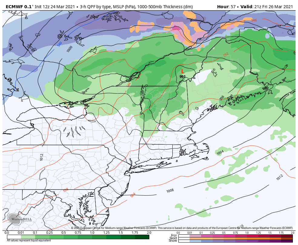
Flood Watch in effect into Saturday Evening…

TODAY: Lots of clouds. Rain showers…moderate to heavy at times with a few embedded thunderstorms…one or two strong. Breezy to windy late today. Still mild. A high 60 to 65. South to southeast winds shifting to southwesterly late at 10 to 20 mph and gusty.

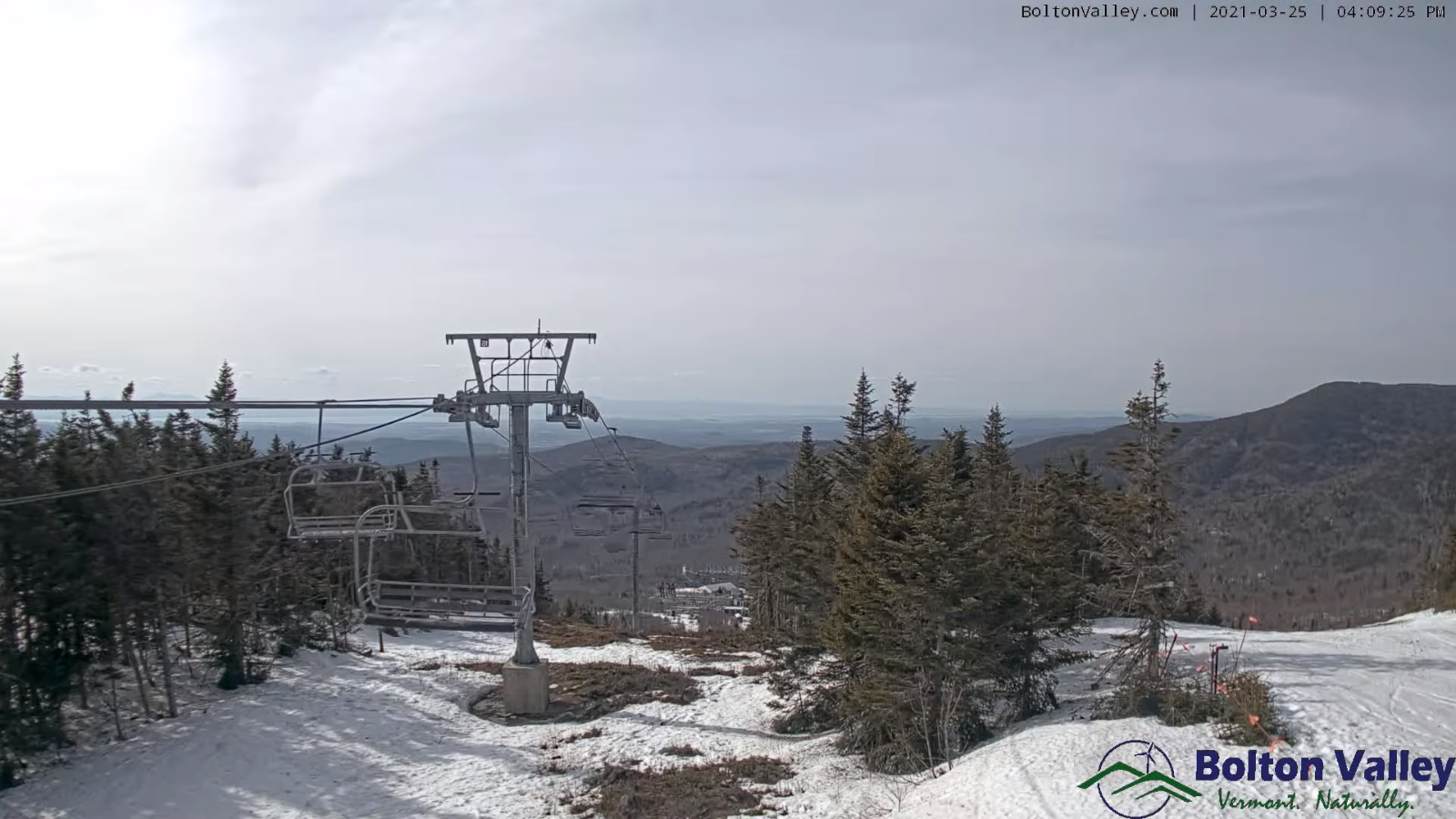
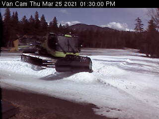
TONIGHT: Cloudy. Showers mixing with wet snow higher northern terrain with a light coating in some elevated areas. A low

32 to 35. West wind shifting to northwest 10 to 25 mph with higher gusts in the mountains.

SATURDAY: Any leftover wet snow flakes far northern areas exit, then intervals of sunshine. A little colder. A high in the mid to upper 40s. Northwest winds 10 mph becoming light.

Looking further ahead…

SATURDAY NIGHT: Overcast. Rain showers likely toward daybreak possibly mixed with wet snow flakes. A low 32 to 35.

SUNDAY: Gray. Periods of rain…moderate to possibly heavy at times in the afternoon. A high 45 to 50.

MONDAY: Clouds and a few leftover snow showers give way to breaks of afternoon sunshine, blustery to windy and colder. A low 20 to 25. A high in the mid-30s

TUESDAY: Clouds mixing with lots of sunshine. An evening low in the mid-20s. A high 50 to 55.

Average low mid-teens to upper-20s Average highs low to mid 40s.

Start of Meteorological Summer June 6th… Summer peaks approx.. July 22nd based off local climatology.

RH/3-26-21 category forecast][end]

Updated Thursday Evening Forecast — March 25th, 2021

TONIGHT: Fair & very mild this evening with a few high clouds, thickening overnight. Rain showers developing before daybreak. A low 45 to 50. Light southeast winds.

Flood Watch Friday morning into Saturday Evening…

TOMORROW: Lots of clouds. Rain showers…moderate to heavy at times in the morning with a few embedded thunderstorms. A round of moderate to heavy rain showers with embedded thunderstorms late afternoon…some strong. Breezy to windy at times and still mild with a high upper 50s to about 60. South to southeast winds shifting to southwesterly late at 10 to 20 mph and gusty.

FRIDAY NIGHT: Cloudy. Scattered rain showers mixing with wet snow north of the Barre-Montpelier. A minor coating in the higher terrain. A low around 35. West wind shifting to northwest 10 to 25 mph with higher gusts in the mountains.

SATURDAY: A few wet snow showers higher terrain northern areas…exiting in the morning. Otherwise clouds with a few breaks of afternoon sunshine. Colder. A high around 45. Northwest winds 10 mph becoming light.

Looking further ahead…

SATURDAY NIGHT: Rising chance for a few rain showers toward daybreak. A low 32 to 35.

SUNDAY: Gray. Good chance for periods of rain moderate to possibly heavy at times. A high 45 to 50.

MONDAY: Clouds and a few leftover snow showers give way to breaks of afternoon sunshine, blustery to windy and colder. A low in the low to mid 20s. A high around 35.

TUESDAY: Clouds mixing with lots of sunshine. A low 20 to 25. A high near 50.

Average low mid-teens to upper-20s Average highs low to mid 40s.

Start of Meteorological Summer June 6th… Summer peaks approx.. July 22nd based off local climatology.

RH/3-25-21 category forecast][end]

Updated Thursday Morning Forecast — March 25th, 2021

TODAY: Morning clouds then periods of sunshine with more clouds again arriving this afternoon. Warmer, with a record high pushing toward 70. Winds becoming southwest 10 to 15 mph.

TONIGHT: Thickening clouds. Rain showers developing before daybreak. A low 45 to 50. Light south winds.

Flood Watch Friday morning into Saturday Evening…

FRIDAY: Gray. Rain showers…moderate to heavy at times in the morning with a few embedded thunderstorms. A round of moderate to heavy rain showers with embedded thunderstorms late afternoon…some strong. Breezy to windy at times and still mild with a high around 60. South to southeast winds shifting to southwesterly at 10 to 20 mph and gusty.

Looking further ahead…

FRIDAY NIGHT: Cloudy. Scattered rain showers changing to wet snow north of the Barre-Montpelier. A dusting to an inch of slush. A low 32 to 35 degrees.

SATURDAY: A few wet snow showers higher terrain northern areas…exiting in the morning. Otherwise clouds with a few breaks of afternoon sunshine. Colder. A high 40 to 45.

SUNDAY: Gray. Chance for rain…mixing with wet snow higher terrain Northeast Kingdom. A low 30 to 35. A high around 40.

MONDAY: Clouds and a few leftover snow showers give way to breaks of afternoon sunshine, blustery to windy and colder. A low 25 to 30. A high around 35.

TUESDAY: Scattered snow showers give way to partial afternoon sunshine and blustery. A low 20 to 25. A high 45 to 50.

Average low mid-teens to upper-20s Average highs low to mid 40s.

Start of Meteorological Summer June 6th… Summer peaks approx.. July 22nd based off local climatology.

RH/3-25-21 category forecast][end]

Updated Wednesday Evening Forecast — March 24th, 2021

TONIGHT:Mostly cloudy. Scattered light rain showers or sprinkles. A low in the mid-40s. Southeast winds 10 mph.

TOMORROW: Partly to mostly sunny. Warmer with a record high 65 to 70. Winds becoming southwest 10 to 15 mph.

THURSDAY NIGHT: Thickening clouds. Rain showers developing toward daybreak. A low 45 to 50. Light south winds.

FRIDAY: Gray. Rain showers…moderate to heavy at times in the morning with a few rumbles of thunder. A round of moderate to briefly heavy rain showers with isolated thunderstorms in the afternoon. Breezy to windy at times with a high 60 to 65. South to southeast winds shifting to southwesterly at 10 to 20 mph and gusty.

Looking further ahead…

FRIDAY NIGHT: Cloudy. Scattered rain showers changing to wet snow north of the Barre-Montpelier. A dusting to an inch of slush. A low near 32 degrees.

SATURDAY: A few wet snow showers higher terrain northern areas…exiting in the morning. Otherwise clouds with a few breaks of afternoon sunshine. Colder. A high in the low 40s.

SUNDAY: Gray. Chance for rain and wet snow. A few inches accumulation especially toward the Northeast Kingdom. A low near 32. A high 35 to 40.

MONDAY: Clouds and a few leftover snow showers give way to breaks of afternoon sunshine, blustery and colder. A low around 30. A high in the mid to upper 30s.

TUESDAY: A low around 20. A high 40 to 45.

Average low mid-teens to upper-20s Average highs low to mid 40s.

Start of Meteorological Summer June 6th… Summer peaks approx.. July 22nd based off local climatology.

RH/3-24-21 category forecast][end]

Updated Wednesday Morning Forecast — March 24th, 2021

TODAY: Clouds mixing with breaks of sunshine. A few late day rain showers developing. A high in the upper 50s or near 60. South winds 10 mph.

TONIGHT:Mostly cloudy. Scattered light rain showers or sprinkles. A low in the mid-40s. South to southeast winds 10 mph.

THURSDAY: Mixed clouds and sun, with more clouds in the afternoon. Warmer with a record high temperature 65 to near 70. Winds becoming southwest 10 to 15 mph.

Looking further ahead…

THURSDAY NIGHT: Thickening clouds. Chance for rain showers after midnight. A low 45 to 50.

FRIDAY: Mainly gray. Occasional rain showers likely…maybe a few rumbles of thunder with possible gusty winds late. A high in the low 60s.

FRIDAY NIGHT: Cloudy. Rain showers, tailing off with wet snow especially northern higher terrain. A light slushy coating of snow higher northern terrain. A low around 35.

SATURDAY: Considerable cloudiness maybe some breaks of sun. Leftover wet snow or rain showers northern elevated terrain. Colder. A high mid-30s far northern areas to low 40s elsewhere.

SUNDAY: Gray. Chance for wet “sugar snow” A few inches accumulation especially elevated terrain. A low 30 to 35. A high mid to upper 30s.

MONDAY: Clouds give way to breaks of afternoon sunshine, blustery and colder. A low around 30. A high in the mid to upper 30s.

Average low mid-teens to upper-20s Average highs low to mid 40s.

Start of Meteorological Summer June 6th… Summer peaks approx.. July 22nd based off local climatology.

RH/3-24-21 category forecast][end]

Updated Tuesday Evening Forecast — March 23rd, 2021

TONIGHT: Fair with periods of high cloudiness. A low 32 to 35.Light south winds.

TOMORROW: Clouds mixing with breaks of sunshine. Maybe a late day rain shower. A high in the upper 50s or near 60. South winds 10 mph.

WEDNESDAY NIGHT:Mostly cloudy. Scattered light rain showers. A low in the mid-40s. South to southeast winds 10 mph.

THURSDAY: Mixed clouds and sun, with more clouds in the afternoon. Warmer. A high 65 to near 70. Winds becoming southwest 10 to 15 mph.

Looking further ahead…

THURSDAY NIGHT: Thickening clouds. Chance for rain showers after midnight. A low 45 to 50.

FRIDAY: Mainly gray. Good chance for occasional rain showers…mixing with wet snow Friday night. A high 55 to 60.

SATURDAY: Considerable cloudiness. Chance for rain showers mixing with wet snow. Possible wet snow accumulation elevated terrain. Colder. Temperatures 35 to 40.

SUNDAY: Gray. Chance for wet “sugar snow” A few inches accumulation especially elevated terrain. A low 30 to 32. A high 35 to 40.

Average low mid-teens to upper-20s Average highs low to mid 40s.

Start of Meteorological Summer June 6th… Summer peaks approx.. July 22nd based off local climatology.

RH/3-23-21 category forecast][end]

Updated Tuesday morning forecast — March 23rd, 2021

TODAY: Sun filtered by high cloudiness. A high in the mid-60s. Light south breeze.

TONIGHT: Fair with high cloudiness. A low 32 to 35.Light south winds.

WEDNESDAY: Mainly cloudy. A rising chance for late day rain showers. A high 55 to 60. Light south breeze.

Looking further ahead…

WEDNESDAY NIGHT:Mainly cloudy. Scattered light rain showers. A low mid to upper 40s.

THURSDAY: Mixed clouds and sun. Warmer. A high mid-60s to around 70.

FRIDAY: Cloudy and turning unsettled. Good chance for rain showers. A low 45 to 50. A high 55 to 60.

SATURDAY: Considerable cloudiness. Chance for rain showers mixing with snow. Possible wet snow accumulation elevated terrain. Colder. Temperatures 35 to 40.

SUNDAY: Gray. Chance for wet “sugar snow” mixed with rain valley floors A few inches accumulation across the elevated terrain. A low 30 to 32. A high 35 to 40.

Average low mid-teens to upper-20s Average highs low to mid 40s.

Start of Meteorological Summer June 6th… Summer peaks approx.. July 22nd based off local climatology.

RH/3-23-21 category forecast][end]

Updated Monday Evening forecast — March 22nd, 2021

TONIGHT: Clear and starlit with a few high clouds toward daybreak. A low 25 to 30. Light south winds.

TOMORROW: Sun filtered by high cloudiness. A high in the mid-60s. Light south breeze.

TUESDAY NIGHT: Fair with high cloudiness. A low in the low to mid 30s.Light south winds.

WEDNESDAY: Mainly cloudy. A high 55 to 60. Light south breeze.

Looking further ahead…

WEDNESDAY NIGHT:Mainly cloudy. Slight chance for a few sprinkles. A low mid to upper 40s.

THURSDAY: Mixed clouds and sun. Warmer. A high mid to upper 60s.

FRIDAY: Cloudy and turning unsettled. Chance for rain showers. A low 45 to 50. A high around 60.

SATURDAY: Considerable cloudiness. Chance for rain or snow showers. Some possible wet snow accumulations in the high terrain. Colder. Temperatures 35 to 40.

SUNDAY: Gray. Chance for light snow showers mixed with rain drops valleys. Possible accumulation in the hills. A low 30 to 32. A high 35 to 40.

Average low mid-teens to upper-20s Average highs low to mid 40s.

Start of Meteorological Summer June 6th… Summer peaks approx.. July 22nd based off local climatology.

RH/3-22-21 category forecast][end]

Updated Monday morning forecast — March 22nd, 2021

TODAY: Sunny & gorgeous. A high in the low 60s. Light south breeze.

TONIGHT: Clear and starlit. A low 25 to 30. Light south winds.

TUESDAY: Sun filtered by a high clouds at times. A high near 65. Light south breeze.

Looking further ahead…

TUESDAY NIGHT: Fair skies with some variable high clouds. A low near 32.

WEDNESDAY: Partial sunshine gives way to thickening clouds later on. Chance for a few sprinkles overnight Wednesday night. A high 55 to 60.

THURSDAY: Mixed clouds and sun. A low in the low to mid 40s. A high 65 to 70.

FRIDAY: Cloudy. Chance for mainly light rain showers. A low in the mid-40s. A high around 55.

SATURDAY: Cloudy. Chance for rain showers…tapering off with a little wet snow…possibly light coating in the high terrain. A low around 35. An early day high in the mid-50s.

Average low mid-teens to upper-20s Average highs low to mid 40s.

Start of Meteorological Summer June 6th… Summer peaks approx.. July 22nd based off local climatology.

RH/3-21-21 category forecast][end]

Updated Friday Evening forecast — March 19th, 2021

TONIGHT: Clear & starlit skies. A low 10 to 15. Light southwest winds.

Vernal Equinox 5:37 AM Saturday…

TOMORROW: Mostly sunny, with a period of high cloudiness in the afternoon. A high in the upper 40s. (Sap run) West breeze 10 mph.

SATURDAY NIGHT: Clear and starlit. A low 20 to 25. Little wind.

SUNDAY: Sunny and milder. A high in the mid to upper 50s. (Sap run). Light northwest winds.

Looking further ahead…

SUNDAY NIGHT: Clear and starlit. A low around 25.

MONDAY: Lots of sunshine. A high near 60.

TUESDAY: Lots of sunshine. A low around 25. A high 60 to 65.

WEDNESDAY: Sunshine mixing with variable high cloudiness. A low 25 to 30. A high 60 to 65.

Average low upper-teens to upper-20s Average highs 40 to 45.

Start of Meteorological Summer June 6th… Summer peaks approx.. July 22nd based off local climatology.

RH/3-19 category forecast][end]