Updated Tuesday Morning Forecast — July 13th, 2021

TODAY: Showers this morning, otherwise mainly cloudy with isolated showers this afternoon. A high in the low 70s. Southeast breeze 10 to 15 mph.

TONIGHT: Mainly cloudy. Chance for a shower or thunderstorm toward daybreak southern western areas. A low 60 to 65. Southeast winds 10 mph.

WEDNESDAY: Mostly cloudy. Scattered afternoon showers and thunderstorms…one or two strong and locally heavy. A high 75 to 80. South breeze 10 to 15 mph.

Looking further ahead…

WEDNESDAY NIGHT: Isolated early evening showers & thunderstorms one or two strong & locally heavy. Otherwise becoming partly cloudy to mostly clear. Patchy valley fog. A low 60 to 65.

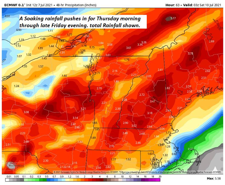
THURSDAY: Morning fog then partly to mostly sunny. Warm and humid. A high 80 to 85.

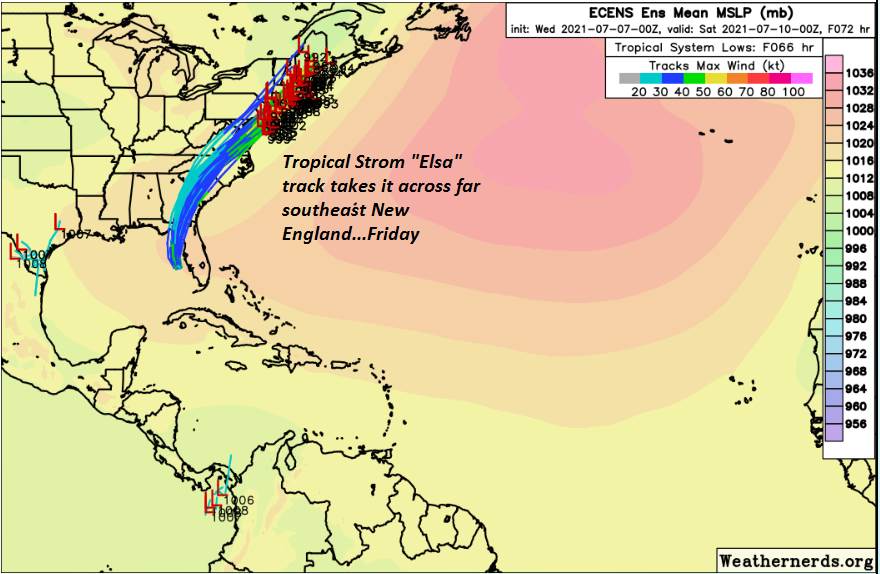
FRIDAY: Sunshine mixed with clouds. Chance for late afternoon showers and storms…possibly strong. Muggy. A low near 65. A high around 85

SATURDAY: Variable cloudiness. Chance for showers & thunderstorms in the morning, some locally heavy. A low 65 to 70. A high in the mid 70s.

Average low mid-50s to low 60s. Average highs in the upper-70s to low 80s.

Meteorological summer peaks approx. July 22nd based off local climatology.

RH/7-13forecast][end]

Updated Monday Evening Forecast — July 12th, 2021

TONIGHT: Partly cloudy north and cloudy southern areas this evening. Becoming overcast overnight. A rising chance for showers after midnight. A low 60 to 65. Light southeast wind.

TOMORROW: Showers likely in the morning, otherwise mainly cloudy. A high in the low 70s. Southeast breeze 10 to 15 mph.

TUESDAY NIGHT: Mainly cloudy. Chance for a shower or thunderstorm late southern areas. A low near 65. Light southeast winds.

WEDNESDAY: Mostly cloudy. Scattered showers with a risk for a few thunderstorms in the afternoon. A high upper 70s to 80. South to southeast winds 10 to 15 mph.

Looking further ahead…

WEDNESDAY NIGHT: Scattered early evening showers with a risk for a few thunderstorms. A low of about 65.

THURSDAY: Clouds mixed with periods of sunshine. A high 80 to 85.

FRIDAY: Lots of sunshine. Chance for a shower or thunderstorm. A low near 60. A high around 85

SATURDAY: Mostly cloudy. Chance for showers & thunderstorms in the morning exiting in the afternoon. A low 65 to 70. A high

upper 70s to around 80.

Average low mid-50s to low 60s. Average highs in the upper-70s to low 80s. .

Meteorological summer peaks approx. July 22nd based off local climatology.

RH/7-12forecast][end]

Updated Monday Morning forecast — July 12th, 2021

TODAY: Gray skies with a period of light rain toward Rutland exiting early. Breaks of sun later this afternoon. A high in the mid-70s. A light east to southeast wind.

TONIGHT: Partly cloudy for a time early…then overcast overnight. A rising chance for a few showers developing overnight. A low 60 to 65. Light southeast wind.

TUESDAY: Lots of clouds. Good chance for a showers. A high 70 to 75. Southeast breeze 10 to 15 mph.

Looking further ahead…

TUESDAY NIGHT: Mainly cloudy. Chance for a shower late southern areas. A low in the low to mid 60s.

WEDNESDAY: Mostly cloudy. Scattered showers with a risk for a few thunderstorms in the afternoon. A high mid to upper 70s.

THURSDAY: Partly sunny. Widely scattered showers isolated thunderstorms. A low 60 to 65. A high around 80.

FRIDAY: Lots of sunshine. An isolated afternoon shower. A low near 60. A high 80 to 85.

SATURDAY: Mostly cloudy. Chance for showers with risk for a thunderstorms in the afternoon. A low near 70. A high 75 to 80.

Average low mid-50s to low 60s. Average highs in the upper-70s to low 80s. .

Meteorological summer peaks approx. July 22nd based off local climatology.

RH/7-12forecast][end]

Updated Friday Evening Forecast — July 9th, 2021

TONIGHT: Maybe an early evening mountain sprinkle. Otherwise, partly cloudy. Patchy valley fog. A low 55 to 60. Light north winds.

TOMORROW: Morning fog burns off to lots of sunshine. A high around 75. Light north breeze.

SATURDAY NIGHT: Mostly clear. Considerable valley fog. A low 50 to 55. Little wind.

SUNDAY: Fog burns off to sunshine becoming filtered by high overcast. A high 75 to 80. Light southwest winds.

Looking further ahead…

SUNDAY NIGHT: Fair with high overcast. A low in the lower 60s.

MONDAY: A few hints of sunshine, then thickening clouds. Scattered late afternoon showers and thunderstorms toward Rutland.

A high low to mid 70s.

TUESDAY: Mostly cloudy. Chance for showers maybe a thunderstorm. A low 60 to 65. A high around 75.

WEDNESDAY: Partly sunny. Scattered afternoon showers and storms. A low mid to upper 60s. A high upper 70s to around 80.

Average low 55 to 60. Average highs in the mid-70s to low 80s. .

Meteorological summer peaks approx. July 22nd based off local climatology.

RH/7-9forecast][end]

Updated Friday Morning Forecast — July 8th, 2021

TODAY: Cloudy & gray. Showers…with areas of drizzle and fog this morning. Showers becoming isolated this afternoon with a few breaks of sunshine possible. A high 70 to 75. Light southeast winds.

TONIGHT: Lots of clouds. An evening sprinkle early then partial clearing overnight. A low 55 to 60. Light northwest winds.

SATURDAY: More sunshine than clouds after morning fog. A high around 75. North breeze 10 mph.

Looking further ahead…

SATURDAY NIGHT: Mostly clear. Considerable valley fog. A low 50 to 55.

SUNDAY: Fog burns off to sunshine becoming filtered by high overcast. A high 75 to 80.

MONDAY: A few hints of sunshine but with high overcast. A low near 60. A high in the mid-70s.

TUESDAY: Mostly cloudy. Chance for showers and a few thunderstorms. A low near 65. A high in the mid-70s.

WEDNESDAY: Partly sunny. Scattered afternoon showers and thunderstorms. A low around 65. A high 80 to 85.

Average low 55 to 60. Average highs in the mid-70s to low 80s. .

Meteorological summer peaks approx. July 22nd based off local climatology.

RH/7-7forecast][end]

Updated Thursday Evening Forecast — July 8th, 2021

Flood Watch Addison to Orange County and points south… tonight and Friday

TONIGHT: Cloudy and damp. A soaking rainfall…moderate at times, maybe a rumble of thunder southern areas. Areas of fog. A low around 60. South to southeast winds 10 mph.

TOMORROW: Overcast. Periods of rain or frequent showers, moderate at times…tapering to scattered showers late.A high in the low 70s. Light southeast winds.

FRIDAY NIGHT: Lots of clouds. An evening sprinkle early then partial clearing overnight. A low in the mid-50s. Light northwest winds.

SATURDAY: Mixed clouds and sun. A high 70 to 75. North breeze 10 mph.

Looking further ahead…

SATURDAY NIGHT: Mostly clear. Considerable valley fog. A low 50 to 55.

SUNDAY: Fog burns off to sunshine becoming filtered through high clouds. A high near 75.

MONDAY: A few hints of sunshine with considerable high cloudiness. A low 55 to 60. A high in the mid to upper 70s.

TUESDAY: Mostly cloudy. Chance for showers and a few thunderstorms. A low near 65. A high mid to upper 70s.

WEDNESDAY: Partly sunny. Scattered afternoon showers and thunderstorms. A low mid to upper 60s. A high 80 to 85.

Average low 55 to 60. Average highs in the mid-70s to low 80s. .

Meteorological summer peaks approx. July 22nd based off local climatology.

RH/7-7forecast][end]

Updated Thursday Morning Forecast — July 8th, 2021

Flood Watch Addison to Orange County and points south… tonight and Friday

TODAY: Gray, cool and damp. Frequent showers moderate at times. Ahigh mid to upper 60s. Southeast breeze 10 to 15 mph.

TONIGHT: Cloudy and damp. A soaking rainfall…moderate at times, maybe a rumble of thunder southern areas. Areas of fog. A low around 60. South breeze 10 mph.

FRIDAY: Overcast. Periods of rain or frequent showers, moderate at times, maybe a rumble of thunder…tapering to scattered showers late.A high in the low 70s Light southeast winds.

Looking further ahead…

FRIDAY NIGHT: An evening sprinkle early then partial clearing. A low 55 to 60.

SATURDAY: Partial morning sun, then lots of afternoon clouds. A high near 75.

SUNDAY: Lots sunshine with a few high clouds. A low 50 to 55. A high near 75.

MONDAY: A few hints of sunshine with considerable high cloudiness. A low around 60. A high in the mid-70s to near 80.

TUESDAY: Mostly cloudy. Chance for showers and a few thunderstorms. A low near 65. A high upper 70s to near 80.

Average low 55 to 60. Average highs in the mid-70s to low 80s. .

Meteorological summer peaks approx. July 22nd based off local climatology.

RH/7-7forecast][end]

Updated Wednesday Evening Forecast — July 7th, 2021

TONIGHT: Lots of clouds. Isolated sprinkles southern areas ending. Rising chance for showers toward sunrise western areas. A low near 55.Light north winds.

TOMORROW: Gray, cool and damp. Frequent showers or periods of rain with a few rumbles of afternoon thunder possible. Ahigh 65 to 70. Southeast breeze 10 to 15 mph.

THURSDAY NIGHT: Cloudy and damp. A soaking rainfall…moderate at times, maybe a rumble of thunder. Areas of fog. A low around 60. South breeze 10 mph.

FRIDAY: Overcast. Periods of rain or frequent showers, moderate at times tapering to scattered showers late.A high around 70. Light southeast winds.

Looking further ahead…

FRIDAY NIGHT: An evening sprinkle early then partial clearing. A low around 55.

SATURDAY: Partial morning sun, then lots of afternoon clouds. A high in the lower 70s.

SUNDAY: Lots sunshine with a few high clouds. A low in the low 50s. A high around 75.

MONDAY: Partly sunny with variable high cloudiness. A low 55 to 60. A high 75 to 80.

Average low 55 to 60. Average highs in the mid-70s to low 80s. .

Meteorological summer peaks approx. July 22nd based off local climatology.

RH/7-7forecast][end]

Updated Wednesday Morning Forecast — July 7th, 2021

TODAY: Mixed clouds and hazy sunshine this morning. Considerable cloudiness this afternoon. Good chance for showers overspreading the region later this afternoon. A high 70 to 75. Light northwest winds.

TONIGHT: Mostly cloudy. Scattered evening showers. A low in the mid-50s.Light north winds.

THURSDAY: Gray skies cool and damp. Showers or periods of rain likely by mid-day. Maybe a rumble or two of thunder late. Ahigh mid-60s to near 70. Southeast breeze 10 to 15 mph.

Looking further ahead…

THURSDAY NIGHT: Cloudy and damp. A soaking rainfall…moderate at times, maybe a rumble of thunder. A low around 60.

FRIDAY: Mainly cloudy. Chance for rain or showers, moderate at times with rumbles of thunder…tapering to widely scattered late afternoon showers. A high in the mid-70s

SATURDAY: Partly to mostly cloudy. A low near 60. A high near 75.

SUNDAY: Lots sunshine with a few high clouds. A low around 55. A high upper 70s to near 80.

MONDAY: Partly sunny with variable high cloudiness. A low around 60. A high around 80.

Average low 55 to 60. Average highs in the mid-70s to low 80s. .

Meteorological summer peaks approx. July 22nd based off local climatology.

RH/7-7forecast][end]

Updated Tuesday Evening Forecast — July 6th, 2021

TONIGHT: An isolated evening shower, otherwise partly cloudy. Patchy valley fog. A low of about 60. Light west to northwest winds.

TOMORROW: Mixed clouds and sun. Widely scattered late day hit or miss showers. A high in the mid-70s. Light northwest winds.

WEDNESDAY NIGHT: Mostly cloudy. Widely scattered evening showers. A low in the mid-50s.Light northeast winds.

THURSDAY: Gray skies cool and damp. Good chance for periods of rain or showers. A high upper 60s to around 70. Southeast breeze 10 mph.

Looking further ahead…

THURSDAY NIGHT: Cloudy and damp. Chance for soaking rainfall…moderate to heavy at times, maybe a rumble of thunder. A low around 60.

FRIDAY: Mainly cloudy. Chance for rain or showers, moderate to heavy at times with rumbles of thunder. A high in the mid-70s

SATURDAY: An isolated mountain sprinkle, otherwise mixed sun and clouds. A low in the low 60s. A high 70 to 75.

SUNDAY: Lots sunshine with a few high clouds. A low 50 to 55. A high 75 to 80.

Average low 55 to 60. Average highs in the mid-70s to low 80s. .

Meteorological summer peaks approx. July 22nd based off local climatology.

RH/7-6forecast][end]