Updated Monday evening Forecast – July 24th, 2023

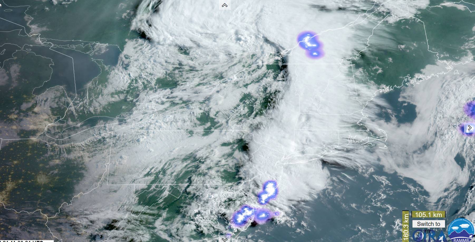
Severe Thunderstorm Watch thru 8 PM…

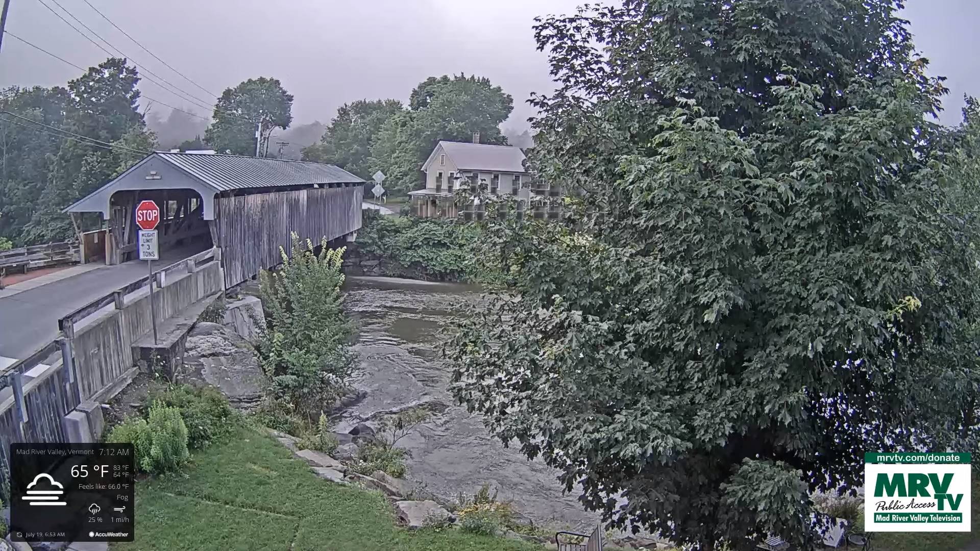
TONIGHT: Scattered showers and thunderstorms a few strong to locally severe early winding down and exiting by late evening. Otherwise clearing. Patchy valley fog. A low in the low 60s. Light south winds.

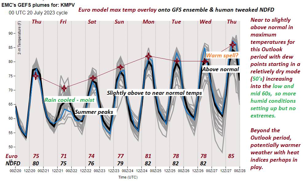
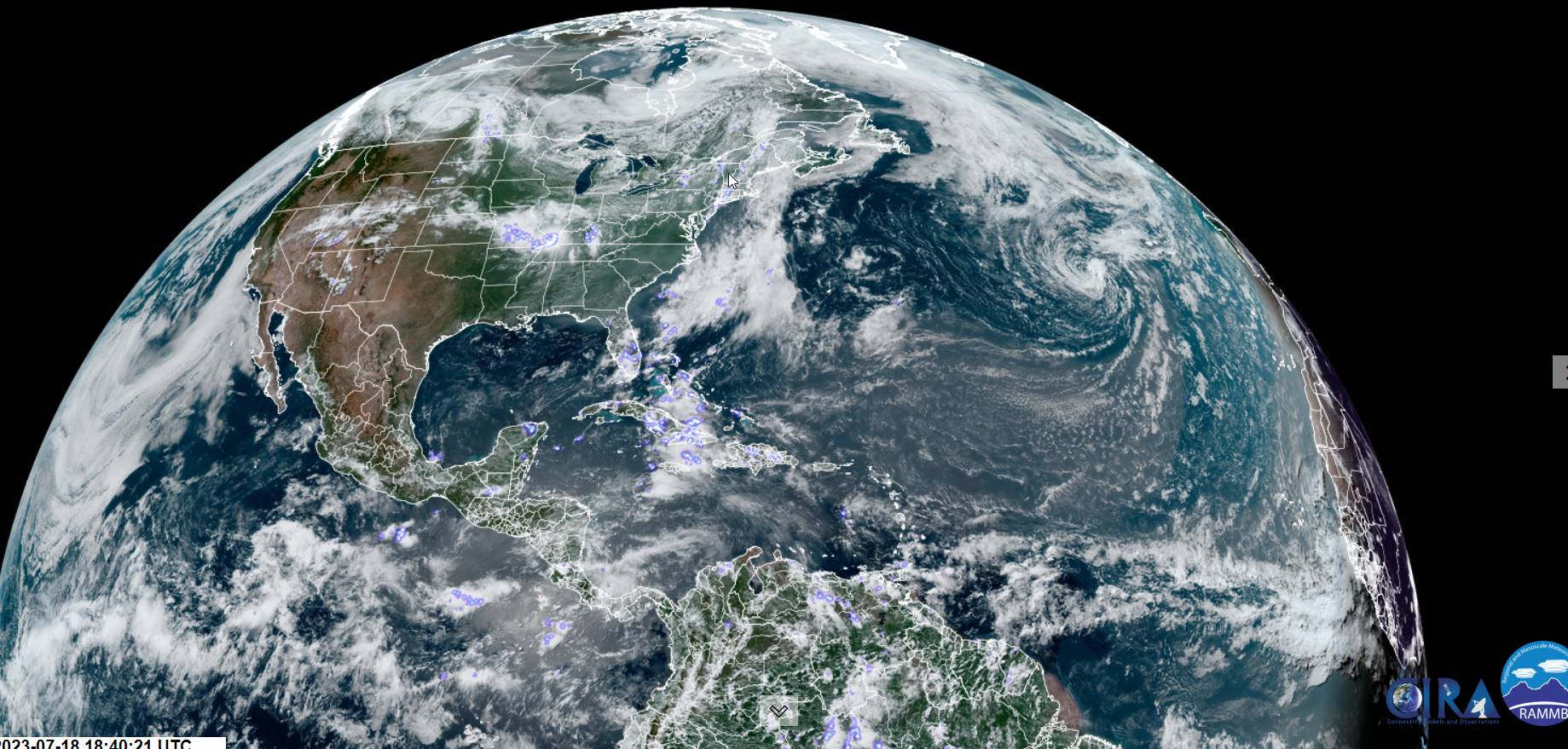
TOMORROW: Sunshine mixed with clouds. Hazy/smoky possibly poor air quality. Isolated hit and miss showers and thunderstorms. A high around 80. Light southwest winds.

TUESDAY NIGHT: Partly cloudy. Isolated hit early evening and miss showers and thunderstorms. A low around 60. Light south to southwest winds.

WEDNESDAY: Morning valley fog burns off to Lots of sunshine. Chance for an afternoon shower or thunderstorm. A high near 80. Southwest breeze 10 mph.

Looking further ahead

WEDNESDAY NIGHT: Thickening clouds, maybe a shower ort storm late. A low 65 to 70.

THURSDAY: Partly to mostly cloudy and steamy. Chance for afternoon showers and thunderstorms some locally heavy. A high mid to possibly upper 80s.

FRIDAY: Mainly morning cloudiness, with the chance for showers and heavy thunderstorms. Intervals of sunshine in the afternoon with isolated thunderstorms possible. Sticky. A low 65 to 70. A high near 85.

SATURDAY: Gray. Chance for rain or showers with embedded heavy thunderstorms. A low around 65, A high in the mid-70s.

Average lows 55 to 60. Average high upper 70s to low 80s.

RH/7-24 forecast][end]

Updated Monday Morning forecast — July 24th, 2023

TODAY: Partly to mostly sunny after morning fog. More muggy and warmer. A rising chance for showers and thunderstorms mid to late afternoon especially central and southern areas. A high in the lower 80s. Light southwest winds.

TONIGHT: Widely scattered showers and isolated thunderstorms winding down early. Otherwise partly cloudy. A low in the low 60s. Light south to southwest winds.

TUESDAY: Sunshine mixed with clouds, Isolated hit and miss showers and thunderstorms. A high around 80. Light west to southwest winds.

Looking further ahead

TUESDAY NIGHT: Partly cloudy. Isolated hit early evening and miss showers and thunderstorms. A low around 60.

WEDNESDAY: Morning valley fog burns off to filtered sun & high clouds. Chance for an afternoon shower or thunderstorm. A high near 80.

THURSDAY: Partly to mostly cloudy and steamy. Chance for afternoon showers and thunderstorms some locally heavy. A low 65 to 70. A high mid to possibly upper 80s.

FRIDAY: Mainly morning cloudiness, with the chance for showers and heavy thunderstorms. Intervals of sunshine in the afternoon with isolated thunderstorms possible. Sticky. A low around 70. A high near 85.

Average lows 55 to 60. Average high upper 70s to low 80s.

RH/7-24 forecast][end]

Updated Friday Evening Forecast — July 21st, 2023

Flood Watch into tonight…

TONIGHT: Scattered showers and isolated heavy thunderstorms for a time this evening. Otherwise becoming partly cloudy, with considerable valley fog overnight. A low in the low 60s. Light south winds.

Approximate peak of summer or half way point…

TOMORROW: Isolated showers northern areas. Otherwise clouds mixing with periods of afternoon sunshine. A high near 75. West to northwest breeze 10 mph.

SATURDAY NIGHT: Mostly clear. Patchy valley fog. A low in the mid to upper 50s. Light southwest winds.

SUNDAY: Lots of sunshine with a few high clouds. A low. A high upper 70s. Light southwest winds.

Looking further ahead

SUNDAY NIGHT: Mostly clear with a few high clouds. A low 55 to 60.

MONDAY: Filtered sunshine thru high clouds thickening up late Muggy and warmer. A rising chance for showers and thunderstorms especially western areas. A high 80 to 85.

TUESDAY: Sunshine mixed with clouds, widely scattered hit and miss showers and thunderstorms. A low 60 to 65. A high near 80.

WEDNESDAY: Morning valley fog & low clouds burn off to lots of sunshine. A low upper 50s. A high near 80.

Average lows 55 to 60. Average high upper 70s to low 80s.

Approximate peak of summer this Saturday…

RH/7-20 forecast][end]

Updated Friday morning forecast — July 21st, 2023

Flood Watch from Mid-day into tonight…

TODAY: Showers, moderate at times with a rumble of thunder this morning. A second round of showers and thunderstorms, some strong and heavy, redevelops later in the afternoon. Muggy. A high in the lower 70s. Southeast breeze 10 to 15 mph.

TONIGHT: Showers, moderate at times, and isolated heavy thunderstorms early to mid-evening, winding down. Otherwise partly to mostly cloudy, with valley fog overnight. A low in the low 60s. Light south winds.

Approximate peak of summer or half way point…

SATURDAY: Isolated showers northern areas. Otherwise clouds mixing with periods of afternoon sunshine. A high near 75. West to northwest breeze 10 mph.

Looking further ahead

SATURDAY NIGHT: Mostly clear. Patchy valley fog. A low in the mid to upper 50s

SUNDAY: Lots of sunshine with a few high clouds. A low. A high upper 70s.

MONDAY: Filtered sunshine thru high clouds thickening up late Muggy and warmer. A rising chance for showers and thunderstorms especially western areas. A low 55 to 60. A high 80 to 85.

TUESDAY: Sunshine mixed with clouds, widely scattered late afternoon showers and thunderstorms. A low 60 to 65. A high near 80.

WEDNESDAY: Morning valley fog burns off to lots of sunshine. A low upper 50s. A high near 80.

Average lows 55 to 60. Average high upper 70s to low 80s.

Approximate peak of summer this Saturday…

RH/7-20 forecast][end]

Updated Thursday Evening Forecast — July 20th, 2023

TONIGHT: Mostly clear this evening, then thickening clouds. A rising chance for showers, maybe a rumble of thunder toward the Champlain Valley late. A low in the low to mid 60s. Light southeasterly winds.

Flood Watch late Friday afternoon into Friday night…

TOMORROW: Showers, moderate at times with a rumble of thunder in the morning, A second round of showers and thunderstorms, some strong and heavy, redevelops later in the afternoon. Muggy. A high in the lower 70s. Southeast breeze 10 to 15 mph.

FRIDAY NIGHT: Showers, moderate at times, and isolated heavy thunderstorms winding down. Otherwise partly to mostly cloudy, with valley fog overnight. A low in the low 60s. Light south winds.

Approximate peak of summer or half way point…

SATURDAY: Widely scattered showers with an isolated rumble of thunder northern areas. Otherwise clouds mixing with periods of afternoon sunshine. A high near 75. West to northwest breeze 10 mph.

Looking further ahead

SATURDAY NIGHT: Mostly clear. Isolated valley fog. A low in the mid to upper 50s

SUNDAY: Lots of sunshine with a few high clouds. A low. A high upper 70s.

MONDAY: Partly to mostly sunny, muggy and warmer. A rising chance for showers and thunderstorms especially western areas. A low 55 to 60. A high 80 to 85.

TUESDAY: Partial sun, then increasing clouds. Chance for showers and thunderstorms.

Average lows 55 to 60. Average high upper 70s to low 80s.

Approximate peak of summer this Saturday…

RH/7-20 forecast][end]

Updated Thursday Morning Weather — July 20th, 2023

TODAY: Partly to mostly sunny. A high upper 70s.Light southwest winds.

TONIGHT: Mostly clear this evening, then thickening clouds. A rising chance for showers, maybe a rumble of thunder toward the Champlain Valley late. A low in the low to mid 60s. Light southeasterly winds.

Flood Watch late Friday afternoon into Friday night…

FRIDAY: Showers, moderate at times with a rumble of thunder in the morning, A second round of showers and thunderstorms, some strong and heavy, redevelops later in the afternoon. Muggy. A high in the lower 70s. South to southeast breeze 10 to 15 mph.

Looking further ahead

FRIDAY NIGHT: Showers, moderate at times, and isolated heavy thunderstorms winding down. A low in the low 60s.

Approximate peak of summer or half way point…

SATURDAY: Widely scattered showers with an isolated rumble of thunder northern areas. Otherwise clouds mixing with periods of afternoon sunshine. A high near 75.

SUNDAY: Lots of sunshine with a few high clouds. A low in the mid to upper 50s. A high upper 70s.

MONDAY: Partly sunny muggy and warmer. Isolated late day showers western areas. A low 55 to 60. A high

80 to 85.

Average lows 55 to 60. Average high upper 70s to low 80s.

Approximate peak of summer this Saturday…

RH/7-20 forecast][end]

Updated Wednesday Night Forecast — July 19th, 2023

TONIGHT: Mostly clear with patchy valley fog. Cooler and a little less humid. A low near 55. Little wind.

TOMORROW: Partly to mostly sunny. A high in the lower 80s.Light southwest winds.

THURSDAY NIGHT: Mostly clear in the evening, then thickening clouds. A rising chance for showers and few thunderstorms toward the Champlain Valley. A low 60 to 65. Light southeasterly winds.

FRIDAY: Clouds with a few intervals of sun. Showers, moderate at times with a rumble of thunder in the morning, A second round of showers and thunderstorms, some strong and heavy, later in the afternoon. Muggy. A high in the mid-70s. South to southeast breeze 10 to 15 mph.

Looking further ahead

FRIDAY NIGHT: Showers, moderate at times, and isolated heavy thunderstorms winding down. A low around 60.

Approximate peak of summer or half way point…

SATURDAY: A few showers maybe a rumble of thunder northern areas early. Otherwise patchy morning fog then partly to mostly sunny. A high 75 to 80.

SUNDAY: Lots of sunshine with a few high clouds. A low in the mid-50s. A high upper 70s.

MONDAY: Partly to mostly sunny. A low near 55. A high in the low 80s.

Average lows 55 to 60. Average high upper 70s to low 80s.

Approximate peak of summer this Saturday…

RH/7-18 forecast][end]

Updated Wednesday Morning forecast — July 19th, 2023

TODAY: Morning fog burns off to hazy sunshine with wildfire smoke clearing out this afternoon. A high around 80. West to northwest breeze 10 mph.

TONIGHT: Mostly clear with patchy valley fog. Cooler and a little less humid. A low near 55. Little wind.

THURSDAY: Partly to mostly sunny. A high in the low 80s.Light south winds.

Looking further ahead

THURSDAY NIGHT: Mostly clear for a time in the evening, then clouding up. A low 60 to 65.

FRIDAY: Cloudy. Rising likelihood for showers, moderate to heavy at times and isolated afternoon heavy thunderstorms. More muggy again. A high in the mid-70s.

Approximate peak of summer or half way point…

SATURDAY: Morning fog burns off to partly to mostly sunny skies. A few showers maybe a rumble of thunder far northern areas. A low around 60. A high 75 to 80.

SUNDAY: Lots of sunshine with a few high clouds. A low in the mid-50s. A high upper 70s.

MONDAY: Partly to mostly sunny. A low near 55. A high in the low 80s.

Average lows 55 to 60. Average high upper 70s to low 80s.

Approximate peak of summer this Saturday…

RH/7-18 forecast][end]

Updated Tuesday evening Forecast — July 18th, 2023

Flood Watch thru 2 AM Wednesday morning…Air Quality Alert thru midnight tonight.

TONIGHT: Showers and isolated heavy thunderstorms lingering into this evening. Partial clearing overnight with valley fog. A low around 60. Light southwest winds.

TOMORROW: Patchy fog burns off to partly to mostly sunny skies. A high around 80. West to northwest breeze 10 mph.

WEDNESDAY NIGHT: Mostly clear with patchy valley fog. Cooler and a little less humid. A low in the mid-50s. Little wind.

THURSDAY: Partly to mostly sunny. A high in the low 80s.Light south winds.

Looking further ahead

THURSDAY NIGHT: Mostly clear for a time in the evening, then increasingly cloudy. A low in the low 60s,

FRIDAY: Cloudy. Rising chance for showers and isolated afternoon heavy thunderstorms. Increasingly more humid. A high 75 to 80.

SATURDAY: Morning cloudiness, giving to partial afternoon sunshine. Widely scattered showers, maybe a thunderstorm. A low around 60. A high 75 to 80.

SUNDAY: Isolated to widely scattered showers. Otherwise partly cloudy. A low in the mid-50s. A high upper 70s.

Average lows 55 to 60. Average high upper 70s to low 80s.

Summer temps peak July 22nd

RH/7-18 forecast][end]

Updated Tuesday Morning forecast — July 18th, 2023

Flood Watch Noon thru 2 AM Wednesday morning…Air Quality Alert thru midnight tonight.

TODAY: Some hazy intervals of sunshine otherwise lots of clouds. Showers and isolated heavy thunderstorms developing this afternoon. A high near 80.Light southwest winds.

TONIGHT: Showers and isolated heavy thunderstorms lingering into this evening. Partial clearing overnight with valley fog. A low around 60. Light southwest winds.

WEDNESDAY: Patchy fog burns off to partly to mostly sunny skies. A high around 80. West to northwest breeze 10 mph.

Looking further ahead

WEDNESDAY NIGHT: Mostly clear with patchy valley fog. Cooler and a little less humid. A low in the mid-50s.

THURSDAY: Partly to mostly sunny. A high in the lower 80s.

FRIDAY: Cloudy. Rising chance for showers and isolated afternoon thunderstorms. Increasingly more humid. A low in the low to mid 60s. A high in the mid-70s.

Average lows 55 to 60. Average high upper 70s to low 80s.

Summer temps peak July 22nd

RH/7-18 forecast][end]