Updated Monday Evening Forecast — July 31st, 2023

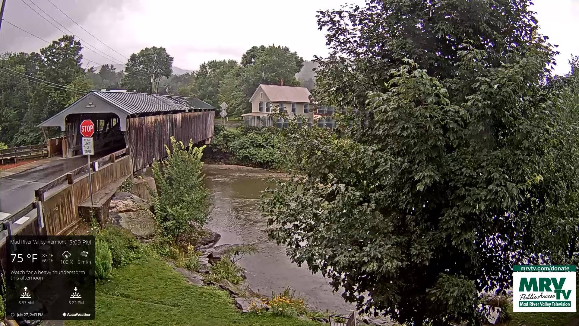
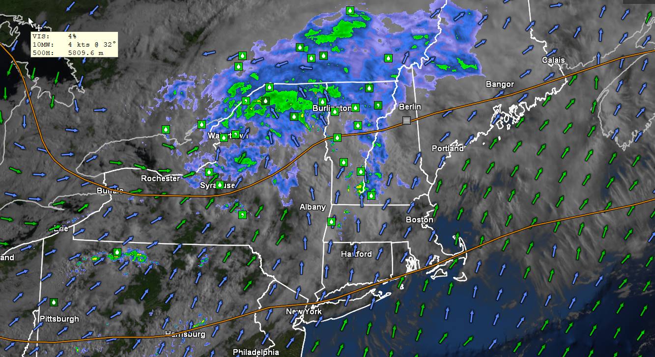
TONIGHT: Any leftover showers exit quickly to fully moonlit skies. Patchy valley fog overnight. A low in the upper 40s. Light northwest winds.

Full Sturgeon Moon 2:32 PM

TOMORROW: Patchy valley fog burns to mixed sun and clouds. Cooler than normal. A high in the mid-60s. Northwest breeze 10 mph.

TUESDAY NIGHT: Mostly clear & fully moonlit skies. Isolated patches of valley fog.A low in the upper 40s. Light west winds.

WEDNESDAY: Mostly sunny with more afternoon clouds. Continued low to moderate humidity. A high upper 60s to near 70. Light northwest winds.

Looking further ahead

WEDNESDAY NIGHT: Fair with high cloudiness and partially moonlit. A low 50 to 55.

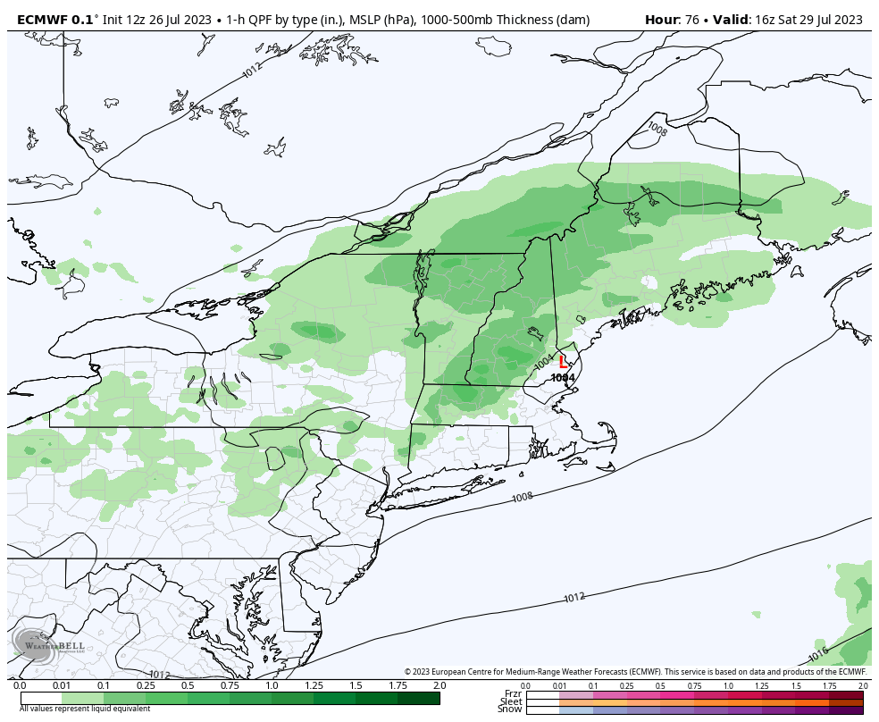
THURSDAY: Brief partial sunshine, then mainly cloudy. Maybe a brief afternoon shower or sprinkle. A bit more humid. A high mid to upper 70s.

FRIDAY: More clouds than sunshine. Scattered showers and thunderstorms in the afternoon. A low in the low 60s. More muggy. A high in the mid-70s.

SATURDAY: Considerable morning clouds, then partly sunny in the afternoon. A low 60 to 65. A high around 70.

Average lows 55 to 60. Average high mid-70s to around 80.

RH/7-31 forecast][end]

Updated Monday Morning forecast — July 31st, 2023

TODAY: Partial sunshine, with scattered showers. An isolated afternoon thunderstorm or two western and southern Vermont clearing late. A high in the upper 60s. West breeze shifting to northwest 10 mph.

TONIGHT: Any leftover showers exit early to fully moonlit skies. Patchy valley fog. A low in the upper 40s. Light northwest winds.

Full Sturgeon Moon 2:32 PM

TUESDAY: Patchy valley fog burns to mixed sun and clouds. Cooler than normal. A high mid to upper 60s. Northwest breeze 10 mph.

Looking further ahead

TUESDAY NIGHT: Mostly clear. Isolated valley fog.A low mid to upper 40s.

WEDNESDAY: Mostly sunny with more afternoon clouds. Continued low to moderate humidity. A high upper 60s to around 70.

THURSDAY: Morning sun gives way to afternoon cloudiness. Maybe a brief afternoon shower or sprinkle. A low around 50. A bit more humid. A high around 75.

FRIDAY: More clouds than sunshine. Scattered showers and thunderstorms in the afternoon. A low in the low 60s. More muggy. A high in the mid-70s.

Average lows 55 to 60. Average high mid-70s to around 80.

RH/7-31 forecast][end]

Updated Friday Evening Forecast — July 28th, 2023

TONIGHT: Fair with some cloudiness near the Quebec border, and a chance for a few thunderstorms this evening. A low mid to upper 60s. Light west winds shifting to northerly.

TOMORROW: Maybe some brief early morning sun, then mainly cloudy & muggy. Rain showers…with a rumble of thunder possible, toward Rutland. Cooler, with a high low to mid 70s. Light northwest breeze.

SATURDAY NIGHT: Becoming mostly clear, & sharply cooler and much less humid. Widespread valley fog. A low 50 to 55. Light northwest winds.

SUNDAY: Sunshine mixing with afternoon clouds. Low to moderate humidity. A high near 70. Northwest breeze 10 mph.

Looking further ahead

SUNDAY NIGHT: Few high clouds thickening up overnight. A low 50 to 55.

MONDAY: Partial morning sunshine gives way to afternoon clouds with a chance for showers. A high in the upper 60s

TUESDAY: Patchy valley fog burns to mixed sun and clouds. Cooler than normal. A low in the upper 40s. A high in the upper 60s.

WEDNESDAY: Patchy valley fog, then mostly sunny. Continued low to moderate humidity. A low 45 to 50. A high around 70,

Average lows 55 to 60. Average high upper 70s to low 80s.

RH/7-27 forecast][end]

Updated Friday morning forecast — July 28th, 2023

TODAY: Morning fog, then hazy sunshine with a few afternoon clouds. Sticky. A high reaching into the mid-80s, with a heat index around or in the low 90s. Light southwest winds.

TONIGHT: Fair most of the region, with some cloudiness near the Quebec border, and a chance for a few thunderstorms. A low around 65. Light southwest winds.

SATURDAY: Maybe some brief early morning sun, then mainly cloudy & muggy. Rain showers…with a rumble of thunder possible, central and southern Vermont. Cooler, with a high around 75. Light north breeze.

Looking further ahead

SATURDAY NIGHT: Becoming mostly clear, & sharply cooler and much less humid. Widespread valley fog. A low 50 to 55.

SUNDAY: Sunshine mixing with afternoon clouds. Low to moderate humidity. A high in the low 70s.

MONDAY: Partial morning sunshine gives way to afternoon clouds with a chance for showers. A low 50 to 55. A high upper 60s.

TUESDAY: Patchy valley fog burns to mixed sun and clouds. Cooler than normal. A low in the upper 40s. A high in the upper 60s.

WEDNESDAY: Patchy valley fog, then mostly sunny. Continued low to moderate humidity. A low 45 to 50. A high around 75.

Average lows 55 to 60. Average high upper 70s to low 80s.

RH/7-27 forecast][end]

Updated Thursday Evening Forecast — July 27th, 2023

Flood Watch thru this evening

TONIGHT: Isolated early evening showers exit. Otherwise gradual clearing to lead to widespread valley fog. A low in the lower 60s. Light west winds.

TOMORROW: Morning fog, then partly to mostly sunny. Sticky. A high pushing into the upper 80s to near 90, with heat indices in the low to mid 90s. Light southwest winds.

FRIDAY NIGHT: Fair in the evening then increasing cloudiness. Isolated thunderstorms near the Quebec border after midnight. A low around 65. Light southwest winds.

SATURDAY: Mainly cloudy & very muggy. Chance for rain or showers with embedded heavy thunderstorms. One or two possibly strong. A high mid to upper 70s. Light north breeze.

Looking further ahead

SATURDAY NIGHT: Becoming mostly clear sharply cooler and much less humid. Widespread valley fog. A low 50 to 55.

SUNDAY: Sunshine mixing with afternoon clouds. Low to moderate humidity. A high in the low 70s.

MONDAY: Partial morning sunshine gives way to afternoon clouds with a chance for showers. A low 50 to 55. A high upper 60s.

TUESDAY: Patchy valley fog burns to mixed sun and clouds. Cooler than normal. A low in the upper 40s. A high in the upper 60s.

WEDNESDAY: Patchy valley fog, then mostly sunny. Continued low to moderate humidity. A low 45 to 50. A high around 75.

Average lows 55 to 60. Average high upper 70s to low 80s.

RH/7-27 forecast][end]

Updated Thursday Morning Forecast — July 27th, 2023

Flood Watch in effect thru this evening

TODAY: Mainly cloudy. Numerous showers or a period of morning rain moderate to briefly heavy…with a few rumbles of thunder. A second round of showers and strong to locally severe thunderstorms redevelops after 2
PM with gusty localized winds and hail possible southern and eastern areas.
A high 75 to 80. South winds shifting to southwesterly 10 to 15 mph in the afternoon.

TONIGHT: Isolated early evening showers and strong thunderstorms weaken and exit. Otherwise gradual clearing leading to widespread valley fog. A low in the lower 60s. Light west winds.

FRIDAY: Morning fog, then partly to mostly sunny. Sticky. A high pushing into the upper 80s to near 90, with heat indices in the low to mid 90s. Light west winds.

Looking further ahead

FRIDAY NIGHT: Fair in the evening then increasing cloudiness. Isolated thunderstorms near the Quebec border after midnight. A low around 65.

SATURDAY: Mainly cloudy & very muggy. Chance for rain or showers with embedded heavy thunderstorms. One or two possibly strong. A high mid to upper 70s.

SUNDAY: Sunshine mixing with afternoon clouds. Much less humid and cooler. A low 50 to 55. A high in the low 70s.

MONDAY: Mixed sun and afternoon clouds. Patchy valley fog. A low 50 to 55. A high upper 60s.

Average lows 55 to 60. Average high upper 70s to low 80s.

RH/7-24 forecast][end]

Updated Wednesday evening Forecast — July 26th, 2023

TONIGHT: Mostly fair with high cloudiness…thickening up overnight and turning muggier. A few pockets valley fog. A low in the mid-60s. South winds 10 mph stronger near Lake Champlain.

TOMORROW: Mainly cloudy. Increasingly sticky. Numerous showers moderate to briefly heavy…with embedded thunderstorms in the morning. A brief break possible, then a round of showers and strong to locally severe thunderstorms late afternoon into the early evening. A high 75 to 80. South winds shifting to southwesterly 10 to 15 mph in the afternoon.

THURSDAY NIGHT: Isolated early evening showers and strong thunderstorms exiting. Otherwise gradual clearing leading to widespread valley fog. Muggy and more uncomfortable. A low in the low to mid 60s. Light west winds.

FRIDAY: Morning fog, then partly to mostly sunny. Sticky. A high around 85 with heat indices around 90. Light west winds.

Looking further ahead

FRIDAY NIGHT: Fair in the evening then increasing cloudiness. Isolated thunderstorms near the Quebec border. A low in the mid-60s.

SATURDAY: Mostly cloudy & very muggy. Chance for rain or showers with embedded heavy thunderstorms. A high mid to upper 70s.

SUNDAY: Sunny with a few high clouds, much less humid and cooler. A low 50 to 55. A high in the low 70s.

MONDAY: Mixed sun and clouds afternoon patchy morning fog. A low 50 to 55. A high upper 60s.

Average lows 55 to 60. Average high upper 70s to low 80s.

RH/7-24 forecast][end]

Updated Wednesday Morning forecast — July 26th, 2023

TODAY: Morning valley fog burns off to hazy sunshine. A high in the low 80s. Southwest breeze 10 mph.

TONIGHT: Mostly fair with thickening high clouds. More muggy. Isolated valley fog. A low in the low 60s. South winds 10 mph stronger near Lake Champlain.

THURSDAY: Lots of clouds with a few intervals of sun early afternoon. Increasingly sticky. Numerous showers moderate to briefly heavy…with embedded thunderstorms in the morning. A brief break possible, then a round of showers and strong to locally severe thunderstorms late afternoon into the early evening in the afternoon. A high upper 70s to near 80. South winds shifting to southwesterly 10 to 15 mph in the afternoon.

Looking further ahead

THURSDAY NIGHT: Isolated early evening showers and strong thunderstorms exiting. Muggy and more uncomfortable. A low 65 to 70.

FRIDAY: Morning fog, then partly to mostly sunny. A good chance for late day and evening showers and heavy thunderstorms northern areas. Sticky. A high 80 to 85 but feeling much hotter with high dew points.

SATURDAY: Mostly cloudy & very muggy. Chance for rain or showers with embedded heavy thunderstorms. A low 65 to 70. A high upper 70s to around 80.

SUNDAY: Sunny with a few high clouds, much less humid and cooler. A low in the low 50s. A high in the low 70s.

MONDAY: Mixed sun and clouds afternoon patchy morning fog. A low around 50. A high upper 60s to around 70.

Average lows 55 to 60. Average high upper 70s to low 80s.

RH/7-24 forecast][end]

Updated Tuesday Night Forecast — July 25th, 2023

TONIGHT: Mostly clear. Any early evening showers dry up. A low in the upper 50s and a touch less humid. Light south to southwest winds.

TOMORROW: Morning valley fog burns off to Lots of sunshine. An isolated shower possible. A high in the low 80s Southwest breeze 10 mph.

WEDNESDAY NIGHT: Mostly fair with thickening high clouds. More muggy. Isolated valley fog. A low 65 to 70. South winds 10 mph stronger near Lake Champlain.

THURSDAY: Considerable cloudiness. Chance for numerous showers moderate to briefly heavy…with embedded thunderstorms. A high mid to upper 70s. Southwest breeze kicks up 10 to 20 mph.

Looking further ahead

THURSDAY NIGHT: Isolated early evening showers and strong thunderstorms exiting. Muggy and more uncomfortable. A low upper 60s.

FRIDAY: Morning fog, then partly to mostly sunny. A rising chance for late day showers and heavy thunderstorms northern border areas. Sticky. A high 80 to 85 but feeling much hotter with high dew points.

SATURDAY: Mostly cloudy. Chance for rain or showers with embedded heavy thunderstorms. A low 65 to 70. A high mid to upper 70s.

SUNDAY: Sunny with a few high clouds, much less humid and cooler. A low in the low 50s. A high in the low 70s.

Average lows 55 to 60. Average high upper 70s to low 80s.

RH/7-24 forecast][end]

Updated Tuesday morning Forecast — July 25th, 2023

TODAY: Morning fog burns off to hazy smoky sunshine. Isolated late afternoon showers and thunderstorms. A high around 80. Light southwest winds.

TONIGHT: Mostly clear. Any early evening showers dry up. A low in the upper 50s. Light south to southwest winds.

WEDNESDAY: Morning valley fog burns off to Lots of sunshine. An isolated shower possible. A high near 80. Southwest breeze 10 mph.

Looking further ahead

WEDNESDAY NIGHT: Mostly fair with thickening high clouds. More muggy. Isolated valley fog. A low 65 to 70.

THURSDAY: Considerable cloudiness. Chance for numerous showers moderate to briefly heavy…with embedded thunderstorms central and southern areas. A high mid to upper 70s.

FRIDAY: Morning fog, then partly to mostly sunny. A rising chance for late day showers and heavy thunderstorms northern border areas. Sticky. A low upper 60s. A high 80 to 85 but feeling much hotter with high dew points.

SATURDAY: Mostly cloudy. Chance for rain or showers with embedded heavy thunderstorms. A low 65 to 70. A high mid to upper 70s.

Average lows 55 to 60. Average high upper 70s to low 80s.

RH/7-24 forecast][end]