Updated Tuesday Evening Forecast — August 29th, 2023

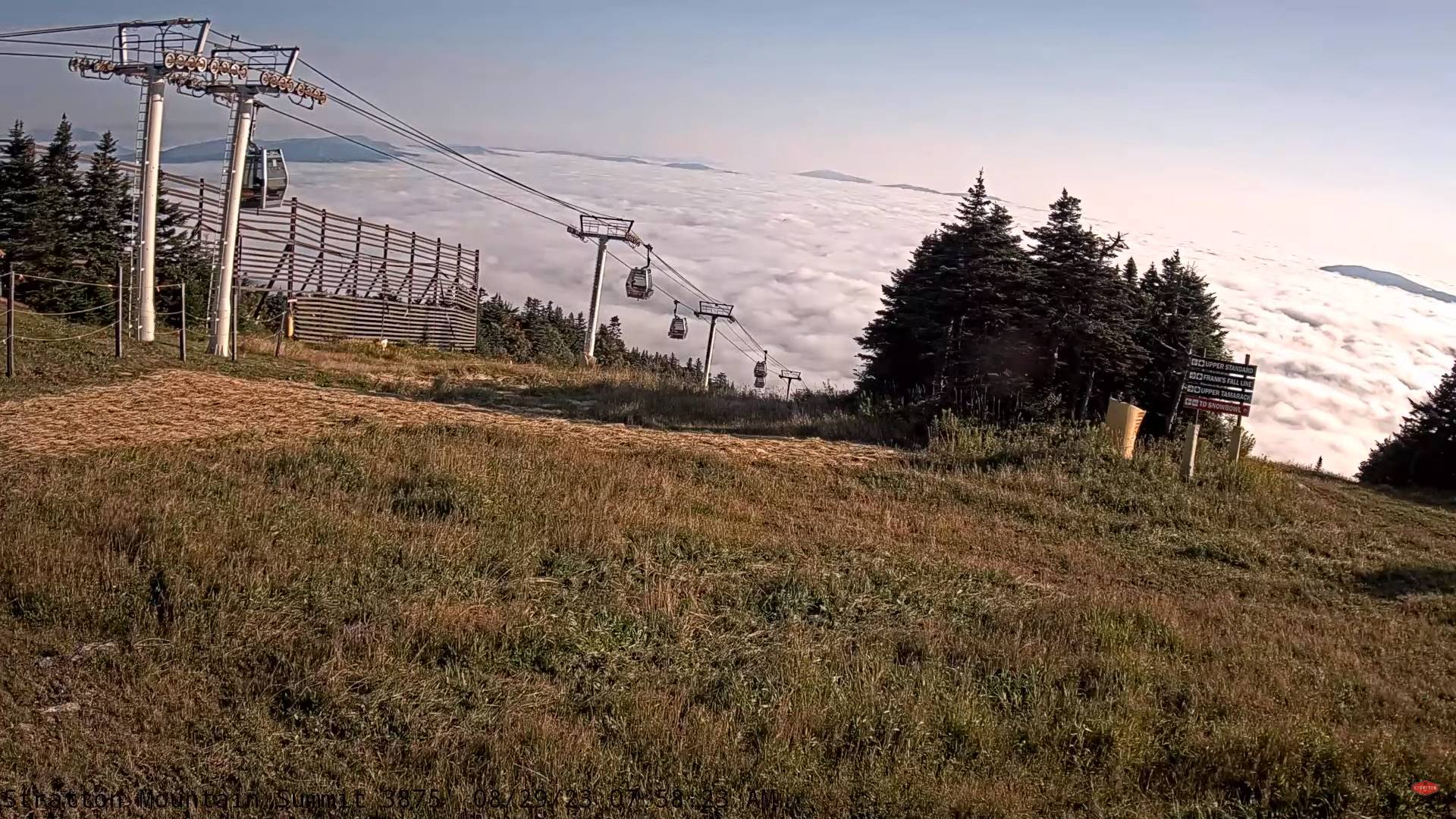
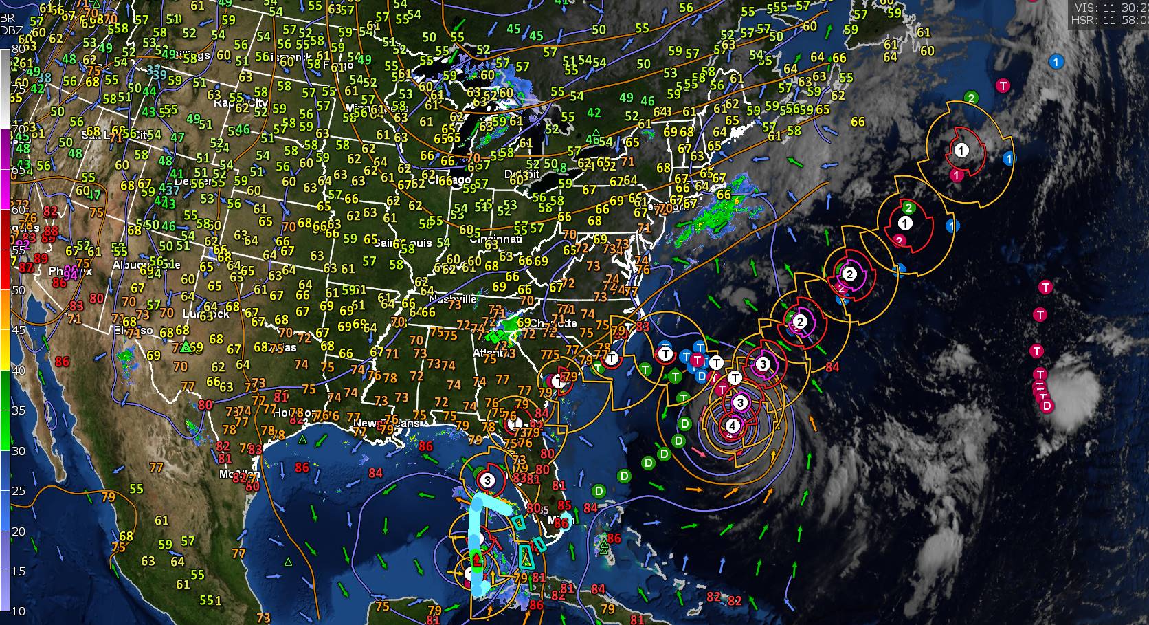
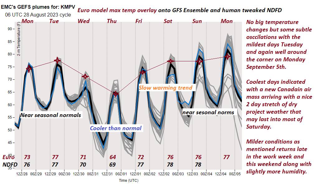
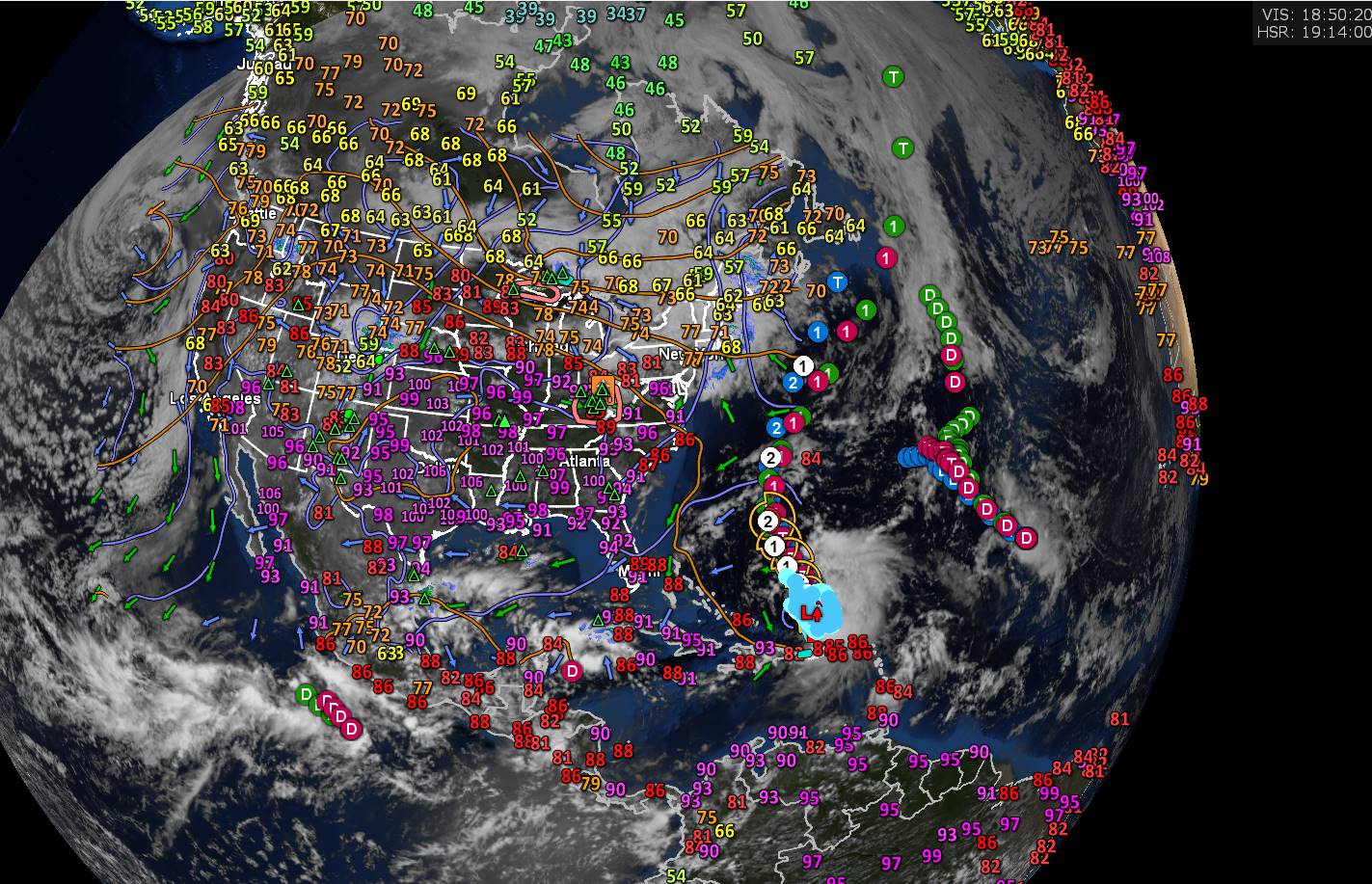
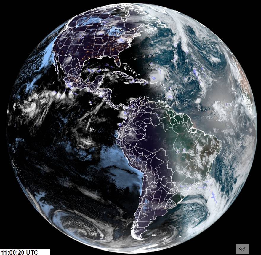
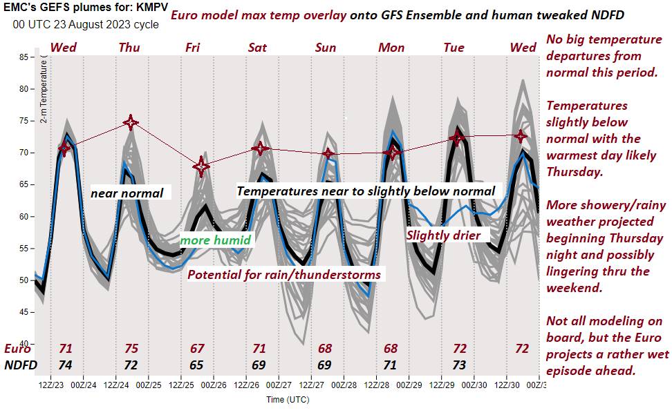
TONIGHT: Thickening clouds.Widely scattered showers becoming more widespread late. A low in the low 60s. Light southeast winds.

TOMORROW: Considerable cloudiness or gray. Morning showers moderate to heavy at times with rumbles of thunder possible northwestern areas exiting to intervals of afternoon sun. A high in the low 70s. Light winds becoming west to northwesterly 10 to 15 mph in the afternoon.

WEDNESDAY NIGHT: Evening cloudiness, eventually clearing less humid blustery and colder. Isolated valley fog. A low in the upper 40s. A gusty northwest wind developing 10 to 20 mph.

THURSDAY: Bright sunshine with a few afternoon clouds and cooler. A high in the mid-60s. Northwest winds 10 to 15 mph.

Looking further ahead

THURSDAY NIGHT: Mostly clear with patchy valley fog. A low around 45.

FRIDAY: Sunny and gorgeous after morning fog. A high 70 to 75.

SATURDAY: Sunshine filtered thru high clouds thickening up late leading to a chance for showers Saturday night. A low around 50. A high mid-70s.

SUNDAY: Morning clouds, then mostly sunny. A low in the mid-50s. A high pushing to around 80.

Average lows upper 40s to mid-50s. Average highs around 75.

RH/8-29 forecast][end]

Updated Tuesday Morning Forecast — August 29th, 2023

TODAY: Clouds with intervals of mainly afternoon sun. Scattered showers toward the northern Champlain valley with a rumble of thunder possible, isolated elsewhere. Warmer and more muggy. A high mid to upper 70s. South breeze 10 mph.

TONIGHT: Lots of clouds and muggier.Widely scattered showers becoming more widespread late. A low in the low 60s. Light southeast winds.

WEDNESDAY: Considerable cloudiness or gray. Morning showers moderate to heavy at times with rumbles of thunder possible northwestern areas. Some breaks of sun possible late. A high around 70. Light winds becoming westerly 10 mph in the afternoon.

Looking further ahead

WEDNESDAY NIGHT: Scattered showers exiting to clearing & blustery overnight. A low upper 40s.

THURSDAY: Bright sunshine and blue skies with a few afternoon clouds and cooler. A high in the mid-60s.

FRIDAY: Sunny and gorgeous after morning fog. A low around 45. A high 70 to 75.

SATURDAY: Sunshine filtered thru high clouds thickening up late leading to a chance for showers Saturday night. A low around 50. A high around 75.

SUNDAY: Morning clouds, then mostly sunny. A low in the mid-50s. A high pushing to near 80.

Average lows upper 40s to mid-50s. Average highs around 75.

RH/8-29 forecast][end]

Updated Monday Evening Forecast — August 28th, 2023

TONIGHT: Partly cloudy for a time early, then clouding up…with showers developing south to north. A low upper 50s around 60. Light south winds.

TOMORROW: Clouds with alternating with periods of afternoon sun. Scattered showers toward the Champlain valley & isolated elsewhere. Warmer and more humid. A high mid to upper 70s. South breeze 10 mph.

TUESDAY NIGHT: Lots of clouds and muggier.Widely scattered showers becoming more widespread late. A low in the low 60s. Light southeast winds.

WEDNESDAY: Considerable cloudiness or gray. Good chance for morning showers, some moderate at times with a rumble of thunder possible. Some breaks of sun possible late. A high around 70. Light winds becoming northwesterly 10 to 15 mph later in the afternoon.

Looking further ahead

WEDNESDAY NIGHT: Scattered showers exiting to clearing & blustery overnight. A low upper 40s.

THURSDAY: Bright sunshine and blue skies with a few afternoon clouds. A high in the mid-60s.

FRIDAY: Sunny and gorgeous after morning fog. A low in the upper 40s. A high in the mid to upper 70s.

SATURDAY: Sunshine filtered thru high clouds thickening up late leading to a chance for showers. A low in the upper 50s. A high pushing toward 80.

Average lows upper 40s to mid-50s. Average highs around 75.

RH/8-28 forecast][end]

Updated Monday Morning Forecast — August 28th, 2023

TODAY: Morning fog, then lots of sunshine with a few more afternoon clouds. Comfortable humidity levels. A high around 75. Winds light and southwesterly.

TONIGHT: Fair most of this evening, then partly to mostly cloudy with a chance of a few showers. A low upper 50s around 60. Light south winds.

TUESDAY: Mostly cloudy a little warmer and more humid. Scattered showers mainly central and northern areas. A high mid to upper 70s. South breeze 10 mph.

Looking further ahead

TUESDAY NIGHT: Lots of clouds and kind of muggy.Widely scattered showers becoming more widespread overnight. A low 60 to 65.

WEDNESDAY: Considerable cloudiness or gray. Chance for showers some moderate at times with a rumble of thunder possible. Some breaks of sun possible late. A high around 70.

THURSDAY: Bright sunshine and blue skies with a touch of autumn. A low upper 40s. A high in the mid-60s.

FRIDAY: Sunny and gorgeous after morning fog. A low in the low to mid 40s. A high in the mid-70s.

SATURDAY: Sunshine filtered thru high clouds thickening up late leading to a chance for showers. A low in the upper 50s. A high 75 to 80.

Average lows upper 40s to mid-50s. Average highs around 75.

RH/8-28 forecast][end]

Updated Friday Evening Forecast — August 25th, 2023

TONIGHT: Considerable evening cloudiness with a few misty showers this evening, drying up overnight with breaks in the clouds. Patchy valley fog. A low upper 50s to low 60s. Little wind.

TOMORROW: More clouds than sun, giving way to increasing sunshine late. Scattered showers with an isolated brief thunderstorm or two. A high near 75. Light northwest winds.

SATURDAY NIGHT: Low clouds and areas of valley fog with patchy drizzle.A low in the upper 50s. Light northwest winds.

SUNDAY: Mixed clouds and intervals of sun. Chance for a shower with a rumbles of thunder toward the Northeast Kingdom. A high around 70. Light north winds.

Looking further ahead

SUNDAY NIGHT: Mostly clear. Considerable valley fog. A low 50 to 55.

MONDAY: Morning fog, then partly sunny skies. Isolated mountain sprinkles. A high in the low 70s.

TUESDAY: Mostly cloudy. Scattered showers & possible thunderstorms. A low around 55. A high near 75.

WEDNESDAY: Gray. Chance for rain or showers, maybe a thunderstorm northern areas. A low upper 50s. A high around 70.

Average lows ranging thru the 50s. Average high low to mid 70s

RH/8-25 forecast][end]

Updated Friday morning Forecast — August 25th, 2023

TODAY: Gray damp and cooler. Showers most prevalent this morning. Misty light showers this afternoon especially near the mountains. Breaks of sun developing late. A high in the upper 60s. South to southeast breeze 10 to 15 mph.

TONIGHT: Considerable cloudiness. A few more misty showers likely. Patchy valley fog. A low upper 50s to low 60s. Little wind.

SATURDAY: Partly to mostly cloudy. Scattered showers with a few embedded brief afternoon thunderstorms. A high near 75. Light northwest winds.

Looking further ahead

SATURDAY NIGHT: Low clouds and areas of valley fog with patchy drizzle.A low in the upper 50s.

SUNDAY: Partly to mostly cloudy. Chance for a shower with a rumbles of thunder toward the Northeast Kingdom. A high around 70.

MONDAY: Morning fog, then partly sunny skies. Isolated mountain sprinkles. A low 50 to 55. A high in the low 70s.

TUESDAY: Mostly cloudy. Scattered showers & possible thunderstorms. A low around 55. A high near 75.

WEDNESDAY: Gray. Chance for rain or showers, maybe a thunderstorm northern areas. A low upper 50s. A high around 70.

Average lows ranging thru the 50s. Average high low to mid 70s

RH/8-25 forecast][end]

Updated Thursday Evening Forecast — August 24th, 2023

TONIGHT: Overcast.Showers arriving before midnight, some moderate at times overnight. A low 55 to 60. Southeast winds 10 mph.

TOMORROW: Gray damp and cool with showers in the morning…becoming isolated in the afternoon with breaks of sun late. A high in the upper 60s. South to southeast breeze 10 to 15 mph.

FRIDAY NIGHT: Variable clouds. Isolated showers northern areas overnight. Patchy valley fog and kind of muggy. A low in the low to mid-60s. Little wind.

SATURDAY: Variably cloudy and more humid. Good chance for showers and isolated thunderstorms especially northern areas. A high in the low to mid 70s. Light northwest winds.

Looking further ahead

SATURDAY NIGHT: Fair early then clouding up overnight. A low in the upper 50s.

SUNDAY: Partly to mostly cloudy. Scattered showers and possible afternoon thunderstorms. A high around 70.

MONDAY: Morning fog, then partly to mostly sunny skies. A low in the upper 50s. A high 70 to 75.

TUESDAY: Clouds with intervals of sun. Scattered showers & possible thunderstorms. A low upper 50s to around 60. A high in the low 70s.

Average lows ranging thru the 50s. Average high low to mid 70s

RH/8-24 forecast][end]

Updated Thursday morning Forecast — August 24th, 2023

TODAY: Valley fogs burn off to morning sunshine, gradually becoming filtered thru high clouds, thickening up late. A high in the mid-70s. South breeze 10 mph, stronger Lake Champlain.

TONIGHT: Overcast.Showers or periods of rain becoming likely by midnight, moderate to heavy at times overnight. A low 55 to 60. Southeast winds 10 mph.

FRIDAY: Gray damp and cool. Rain or showers likely in the morning…becoming isolated in the afternoon. A high 65 to 70. South to southeast breeze 10 to 15 mph.

Looking further ahead

FRIDAY NIGHT: Cloudy with a few breaks. Isolated showers northern areas overnight. Patchy valley fog. A in the low 60s.

SATURDAY: Variably cloudy and more humid. Good chance for showers and isolated thunderstorms especially northern areas. A high in the low 70s.

SUNDAY: Mostly cloudy. Scattered showers and possible afternoon thunderstorms. A low in the upper 50s. A high around 70.

MONDAY: Morning fog burns off to lots of sunshine. A low in the upper 50s. A high 70 to 75.

TUESDAY: Clouds with intervals of sun. Scattered showers & possible thunderstorms. A low upper 50s to around 60. A high in the low 70s.

Average lows ranging thru the 50s. Average high low to mid 70s

RH/8-24 forecast][end]

Updated Wednesday Evening Forecast — August 23rd, 2023

TONIGHT: Clear with patchy valley fog. A low in the low 50s. Little wind.

TOMORROW: Sunshine filtered thru high clouds, thickening up late. A high in the mid-70s. South breeze 10 mph.

THURSDAY NIGHT: Overcast.Showers or periods of rain becoming likely by midnight, moderate to heavy at times overnight. A low in the upper 50s. Southeast winds 10 mph.

**The purple/blueish spots in the clouds are lightning**

FRIDAY: Gray damp and cool. Rain or showers likely in the morning, possibly a thunderstorm far western areas. Showers becoming isolated in the afternoon. A high 65 to 70. South to southeast breeze 10 to 15 mph.

Looking further ahead

FRIDAY NIGHT: Cloudy with a few breaks. Patchy valley fog. A low 60 to 65.

SATURDAY: Partial morning sun, then lots of afternoon clouds. Muggier. Chance for a few showers and rumbles of thunder in the afternoon. A high 70 to 75.

SUNDAY: Mostly cloudy. Chance for showers and possible afternoon thunderstorms. A low 55 to 60. A high in the upper 60s.

MONDAY: Morning fog burns off to lots of sunshine. A low in the 50s. A high upper 60s to around 70.

Average lows ranging thru the 50s. Average high low to mid 70s

RH/8-23 forecast][end]

Updated Wednesday Morning Forecast — August 23rd, 2023

TODAY: Morning valley fog burns off to bright sun and blue skies. Another gorgeous day. A high 70 to 75. Light west winds.

TONIGHT: Mostly clear with patchy valley fog. A low in the low 50s. Light south winds.

THURSDAY: Sunshine becoming filtered thru high clouds, thickening up late. A high around 75. South breeze 10 mph.

Looking further ahead

THURSDAY NIGHT: Overcast.Showers or periods of rain becoming likely by midnight, moderate to heavy at times overnight. A low mid to upper 50s.

FRIDAY: Gray damp and cool. Rain or showers likely in the morning, possibly a thunderstorm far western areas. Showers becoming isolated in the afternoon. A high 65 to 70.

SATURDAY: Continued unsettled and muggier. Mixed clouds and sunshine. Chance for a few showers and rumbles of thunder in the afternoon. A low 60 to 65. A high 70 to 75.

SUNDAY: Partly to mostly cloudy. Chance for showers and possible afternoon thunderstorms. A low 55 to 60. A high in the upper 60s.

MONDAY: Partly sunny. A low in the 50s. A high upper 60s to around 70.

Average lows ranging thru the 50s. Average high low to mid 70s

RH/8-22 forecast][end]