Updated Friday morning Forecast — September 29th, 2023

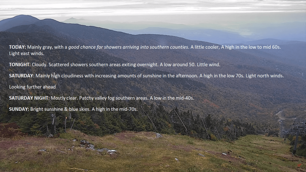
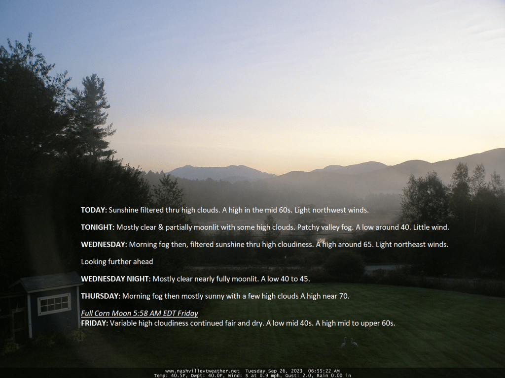
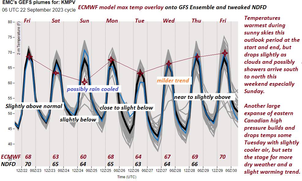
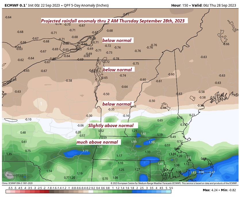
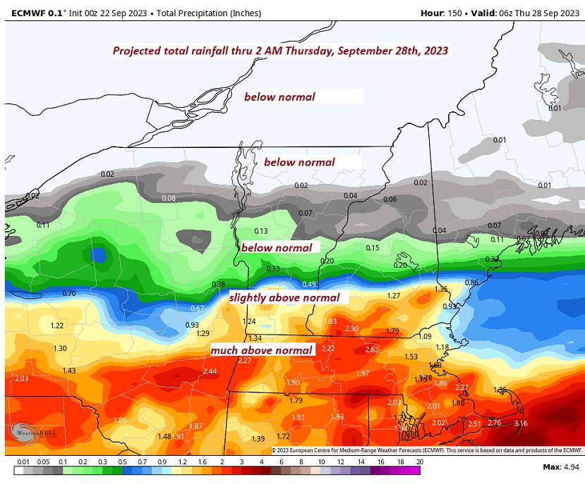
TODAY: Mainly gray, with a good chance for showers arriving in southern counties. A little cooler, a high in the low to mid-60s. Light east winds.

TONIGHT: Cloudy. Scattered showers in southern areas exiting overnight. A low around 50. Little wind.

SATURDAY: Mainly high cloudiness with increasing amounts of sunshine in the afternoon. A high in the low 70s. Light north winds.

Looking further ahead

SATURDAY NIGHT: Mostly clear. Patchy valley fog in southern areas. A low in the mid-40s.

SUNDAY: Bright sunshine & blue skies. A high in the mid-70s.

MONDAY: Sunshine with high clouds. A low in the upper 40s. A high 70 to 75.

TUESDAY: Lots of sunshine with a few clouds in northern regions. A low 50 to 55. A high around 75.

WEDNESDAY: Partly to mostly sunny and warmer than normal. A low 50 to 55. A high 75 to 80.

Average lows upper 30s to mid-40s. Average highs are 60 to 65.

Admin: off Monday and Tuesday back Wednesday

RH/9-29 forecast][end]

Moisture pushes north today – back to lots of sunshine tomorrow afternoon and beyond…

Moisture in the form of mid and high cloudiness was squirting northward into the state, where a few showers were likely in the southern counties, slight threat as far north as Addison to Orange counties. This retreats in bulk overnight and then more sun develops on Saturday setting up the next string of excellent weather days into the middle of next week.

Updated Wednesday morning Forecast — September 27th, 2023

TODAY: Morning fog then, filtered sunshine thru high cloudiness. A high around 65. Light northeast winds.

TONIGHT: Mostly clear nearly fully moonlit.Patchy valley fog.A low in the low 40s. Little wind.

THURSDAY: Morning fog then mostly sunny with more high clouds. A high around 70. Light east winds.

Looking further ahead

THURSDAY NIGHT: Mostly clear in the evening, with a few more high clouds. A low in the low to mid 40s.

Full Corn Moon 5:58 AM EDT Friday

FRIDAY: Considerable high cloudiness with hints of sun. A high mid 60s.

SATURDAY: Sunshine mixed with variable high cloudiness. A low 45 to 50. A high in the lower 70s.

SUNDAY: Bright sunshine. A low around 45. A high around 75.

MONDAY: Mostly sunny. A low 45 to 50. A high near 75.

TUESDAY: Mostly sunny. A low in the mid 50s. A high in the mid 70s.

WEDNESDAY: Partly to mostly sunny and warmer than normal. A low in the mid 50s. A high 75 to 80.

Average lows upper 30s to mid 40s. Average highs 60 to 65.

Admin: off Wednesday afternoon & Tomorrow. Back Friday.

RH/9-27 forecast][end]

Updated Tuesday Night Forecast — September 26th, 2023

TONIGHT: Mostly clear & partially moonlit with some high clouds. Patchy valley fog. A low around 40, slight threat for isolated frost. Little wind.

TOMORROW: Morning fog then, filtered sunshine through high cloudiness. A high around 65. Light northeast winds.

WEDNESDAY NIGHT: Mostly clear nearly fully moonlit.A low 40 to 45. Little wind.

THURSDAY: Morning fog then mostly sunny with a few high clouds. A high near 70. Light east winds.

Looking further ahead

THURSDAY NIGHT: Mostly clear in the evening, with a few more high clouds. A low mid 40s.

Full Corn Moon 5:58 AM EDT Friday

FRIDAY: Variable high cloudiness continued fair and dry. A high mid to upper 60s.

SATURDAY: Mostly sunny after morning fog with a few afternoon clouds. A low 45 to 50. A high around 70.

SUNDAY: Bright sunshine. A low upper 40s. A high 70 to 75.

MONDAY: Sunny. A low 50 to 55. A high near 75.

Average lows upper 30s to mid-40s. Average highs are 60 to 65.

Admin: off Wednesday afternoon & Thursday.

RH/9-26 forecast][end]

Updated Tuesday Morning Forecast — September 26th, 2023

TODAY: Sunshine filtered thru high clouds. A high in the mid 60s. Light northwest winds.   

TONIGHT: Mostly clear & partially moonlit with some high clouds. Patchy valley fog. A low around 40. Little wind.

WEDNESDAY: Morning fog then, filtered sunshine thru high cloudiness. A high around 65. Light northeast winds.

Looking further ahead

WEDNESDAY NIGHT: Mostly clear nearly fully moonlit.A low 40 to 45.

THURSDAY: Morning fog then mostly sunny with a few high clouds A high near 70.

Full Corn Moon 5:58 AM EDT Friday

FRIDAY: Variable high cloudiness continued fair and dry. A low mid 40s. A high mid to upper 60s.

SATURDAY: Mostly sunny after morning fog with a few afternoon clouds. A low 45 to 50. A high around 70.

SUNDAY: Bright sunshine. A low upper 40s. A high 70 to 75.

MONDAY: Sunny. A low 50 to 55. A high near 75.

Average lows upper 30s to mid 40s. Average highs 60 to 65.

Admin: off Wednesday afternoon & Thursday.

RH/9-26 forecast][end]

Updated Monday Night Forecast — September 25th, 2023

TONIGHT: Mostly clear & partially moonlit with some high clouds overnight. Patchy valley fog. A low 40 to 45. Light northeast winds.

TOMORROW: Sunshine filtered thru high cloudiness. A high in the mid 60s. Light northwest winds.   

TUESDAY NIGHT: Mostly clear & partially moonlit with some high cloudiness. Patchy valley fog. A low around 40. Little wind.

WEDNESDAY: Morning fog then, filtered sunshine thru high cloudiness. A high around 65. Light northeast winds.

Looking further ahead

WEDNESDAY NIGHT: Mostly clear nearly fully moonlit.A low 40 to 45.

THURSDAY: Morning fog then mostly sunny with a few high clouds A high near 70.

Full Corn Moon 5:58 AM EDT Friday

FRIDAY: Variable high cloudiness continued fair and dry. A low mid 40s. A high 65 to 70.

SATURDAY: Mostly sunny after morning fog with a few afternoon clouds. A low 45 to 50. A high 70 to 75.

SUNDAY: Bright sunshine. A low upper 40s. A high pushing near 75.

Average lows upper 30s to mid 40s. Average highs 60 to 65.

Admin: off Wednesday afternoon & Thursday.

RH/9-25 forecast][end]

Updated Monday Morning Forecast — September 25th, 2023

TODAY: Morning fog burns off to considerable high cloudiness central and southern areas, gradually giving way to increasing sunshine northwest to southeast. A high in the mid 60s. Light northeast winds.

TONIGHT: Mostly clear with some high clouds overnight. Patchy valley fog. A low 40 to 45. Light east winds.

TUESDAY: Sunshine filtered thru high cloudiness. A high low to mid 60s. Light northwest winds.

Looking further ahead

TUESDAY NIGHT: Mostly clear with some high cloudiness. Patchy valley fog. A low 40 to 45.

WEDNESDAY: Morning fog then, filtered sunshine thru high cloudiness. A high mid to upper 60s.

THURSDAY: Morning fog then mostly sunny with a few high clouds.A low 40 to 45. A high mid to upper 60s.

FRIDAY: Variable high cloudiness continued fair and dry. A low low to mid 60s. A high near 70.

SATURDAY: Mostly sunny after morning fog. A low around 45. A high 70 to 75.

SUNDAY: Bright sunshine. A low around 45. A high pushing near 75.

Average lows upper 30s to mid 40s. Average highs 60 to 65.

Admin: off Wednesday afternoon & Thursday.

RH/9-25 forecast][end]

Updated Friday Evening Forecast — September 22nd, 20123

TONIGHT: Autumnal Equinox 2:49 AM Fair with high overcast. A low 45 to 50. Light southeast winds.

TOMORROW: High cloudiness thickening up in the afternoon. Just a little cooler. A high upper 50s central and southern areas to mid-60s northern areas. Light east winds.

SATURDAY NIGHT: A few brief showers or sprinkles possible Barre-Montpelier area south. A low in the lower 50s. Little wind.

SUNDAY: Gray. Chance for showers southern areas followed by gradual clearing late. A high 60 to 65. Light northeast breeze.

Looking further ahead

SUNDAY NIGHT: Mostly clear.Considerable valley fog.A low 45 to 50.

MONDAY: Lots of clouds with intervals of sun in northern areas. A high mid to upper 60s.

TUESDAY: Sunshine with a few high clouds. A low 45 to 50. A high near 65

WEDNESDAY: Bright and sunny. A low upper 30s to mid-40s. A high 65 to 70. Potentially several more dry days follow…

Average lows in the low to mid 40s. Average highs mid to upper 60s.

RH/9-22 forecast][end]

Updated Friday Morning Forecast — September 22nd, 2023

TODAY: Morning valley fog, then hazy sunshine with high cloudiness developing late. A high near 70. Light southeast breeze.

Autumnal Equinox 2:49 AM

TONIGHT: Fair with high overcast. A low 45 to 50. Light southeast winds.

SATURDAY: High cloudiness thickening up in the afternoon. Just a little cooler. A high upper 50s central and southern areas to mid-60s northern areas. Light east winds.

Looking further ahead

SATURDAY NIGHT: Scattered showers or sprinkles southern Vermont. A low 45 to 50

SUNDAY: Gray. Chance for showers southern and central areas, remaining dry far north. A high ranging upper 50s southern areas, to mid-60s north.

MONDAY: Lots of clouds with intervals of sun in northern areas. Maybe an afternoon shower. A low 45 to 50. A high mid to upper 60s.

TUESDAY: Sunshine with a few afternoon clouds. A low 45 to 50. A high near 65

WEDNESDAY: Bright and sunny. A low upper 30s to mid-40s. A high 65 to 70.

Average lows in the low to mid 40s. Average highs mid to upper 60s.

RH/9-22 forecast][end]