
Heavier rainfall advances eastward this evening. Sunday should not be a wash-out, but a few widely scattered light showers or sprinkles, blustery cooler conditions pushes in on a gusty west to southwest wind.

Heavier rainfall advances eastward this evening. Sunday should not be a wash-out, but a few widely scattered light showers or sprinkles, blustery cooler conditions pushes in on a gusty west to southwest wind.
TONIGHT: Cloudy. A rising chance for showers across mainly southern and western Vermont. A bit humid and damp.A low near 60. Southeast breeze 10 mph.
TOMORROW: Gray, damp, and breezy at times. An occasional light shower, especially in western areas, becomes numerous and heavier later. A high near 65. Southeast breeze 10 mph shifting to northwesterly late.
SATURDAY NIGHT: Showers…or periods of rain…moderate to heavy for a time in the evening. Maybe a rumble of thunder. Partial clearing develops in late southern and central areas. A low in the mid to upper 40s. Southwest winds 10 to 20 mph & blustery.
SUNDAY: Morning clouds & lingering showers in the north early, otherwise intervals of sun, blustery and colder. Isolated leftover mountain sprinkles.A high ranging in the mid to upper 50s. South to southwest winds 10 mph.
Looking further ahead
SUNDAY NIGHT: Mostly clear or becoming so.A low upper 30s to near 40.
MONDAY: Partly to mostly cloudy northern and western areas with a chance for a shower. Mixed sun and clouds otherwise. A chilly daytime high in the low 50s.
TUESDAY: Sunshine mixed with clouds. Scattered showers developing late. A low 35 to 40 with pockets of frost is possible. A high near 55.
WEDNESDAY: Mixed sun and clouds and isolated showers. A low around 40. A high 55 to 60.
Average lows upper 30s to low 40s. Average highs upper 50s to lower 60s.
RH/10-6 forecast][end]
TODAY: Cloudy.Isolated light sprinkles or showers mainly in southern areas this afternoon.A high near 70. South breeze 10 to 15 mph.
TONIGHT: Cloudy. A rising chance for showers across mainly southern and western Vermont. A bit humid and damp.A low near 60. Southeast breeze 10 mph.
SATURDAY: Gray, damp, and breezy with an occasional shower becoming more numerous and heavier in western areas later in the afternoon. A high of about 65. Southeast breeze 10 mph shifting to northwesterly late.
Looking further ahead
SATURDAY NIGHT: Cloudy. Showers…or periods of rain…moderate to heavy for a time. Maybe a rumble of thunder. A low in the mid-40s.
SUNDAY: Morning clouds with lingering showers likely. Turning blustery with partial afternoon clearing and isolated leftover sprinkles.A high in the mid to upper 50s.
MONDAY: Lots of clouds in northern and western areas with a chance for mountain sprinkles or brief showers, otherwise mixed sun and clouds. A low near 40. A high 50 to 55.
TUESDAY: Sunshine mixed with clouds. Scattered showers developing late. A low 35 to 40. A high near 55.
WEDNESDAY: Mixed sun and clouds and isolated showers. A low around 40. A high 55 to 60.
Average lows upper 30s to low 40s. Average highs upper 50s to lower 60s.
RH/10-6 forecast][end]
TONIGHT: Gradually thickening clouds. A low around 55.South to southeast breeze 10 mph, stronger near Lake Champlain.
TOMORROW: Cloudy.A rising chance for showers mainly in southern and eastern Vermont. A high in the upper 60s. South breeze 10 to 15 mph.
FRIDAY NIGHT: Cloudy. A rising chance for showers across western areas after midnight. A low around 60. Southeast breeze 10 mph.
SATURDAY: Gray.Breezy. Scattered showers. A high in the mid-60s. Southeast breeze 10 mph.
Looking further ahead
SATURDAY NIGHT: Cloudy. Showers are likely, some moderate at times with a few rumbles of thunder possible in the evening. A low in the mid-40s.
SUNDAY: Morning clouds with lingering showers likely. Turning blustery with partial afternoon clearing and isolated leftover sprinkles.A high in the upper 50s.
MONDAY: Lots of clouds in northern and western areas with a chance for mountain sprinkles or brief showers, otherwise mixed sun and clouds. A low 40 to 45. A high in the low 50s.
TUESDAY: Sunshine mixed with clouds. A low upper 30s to around 40. A high in the low to mid-50s.
WEDNESDAY: Mixed sun and clouds. A low in the mid to upper 30s. A high near 60.
Average lows upper 30s to low 40s. Average highs upper 50s to lower 60s.
RH/10-5 forecast][end]
TODAY: Sunshine becoming filtered through high clouds, a little cooler with a high in the upper 70s. South breeze 10 mph, stronger near Lake Champlain.
TONIGHT: Thickening clouds.A low around 55. South to southeast breeze 10 mph stronger near Lake Champlain.
FRIDAY: Cloudy.A rising chance for showers mainly in southern and eastern Vermont. A high in the upper 60s. South breeze 10 to 15 mph.
Looking further ahead
FRIDAY NIGHT: Cloudy. Showers becoming likely across western areas. A low around 60.
SATURDAY: Overcast. Showers are likely, some moderate at times in western areas, with a few rumbles of thunder possible. Breezy. A high in the mid-60s.
SUNDAY: Partly cloudy, unsettled, and becoming blustery, with scattered showers.A low in the mid-40s. A high in the upper 50s.
MONDAY: More sun than clouds. Chance for mountain sprinkles or brief showers. A low 40 to 45. A high in the
low 50s.
TUESDAY: Partly to mostly cloudy. A low upper 30s to around 40. A high in the low to mid-50s.
WEDNESDAY: Mixed sun and clouds. A low in the mid to upper 30s. A high near 60.
Average lows upper 30s to low 40s. Average highs upper 50s to lower 60s.
RH/10-5 forecast][end]
TONIGHT: Mostly clear with considerable valley fog overnight. A low in the upper 50s to around 60. Light southeast breeze.
TOMORROW: Sunshine filtered thru high cloudiness with a strong cooling trend. A high 75 to 80. South breeze 10 mph, stronger near Lake Champlain.
THURSDAY NIGHT: Thickening high cloudiness.A low around 55.South to southeast breeze 10 mph stronger near Lake Champlain.
FRIDAY: Mostly cloudy.A rising chance for showers southern areas spreading north in the afternoon. A high around 70. South winds 10 to 20 mph.
Looking further ahead
FRIDAY NIGHT: Lots of clouds. Showers likely, a few moderate at times. A low in the low 60s
SATURDAY: Overcast.Good chance for frequent showers, some moderate to briefly heavy, maybe a rumble of thunder western areas. A high around 65.
SUNDAY: Variable cloudiness & unsettled with scattered showers.A low upper 40s. A high 50 to 55.
MONDAY: Mixed sun and clouds. Chance for mountain sprinkles or brief showers. A low 40 to 45. A high 50 to 55.
TUESDAY: Partly to mostly cloudy. A low 40 to 45. A high in the low to mid 50s.
Average lows upper 30s to low 40s. Average highs upper 50s to lower 60s.
RH/10-4 forecast][end]

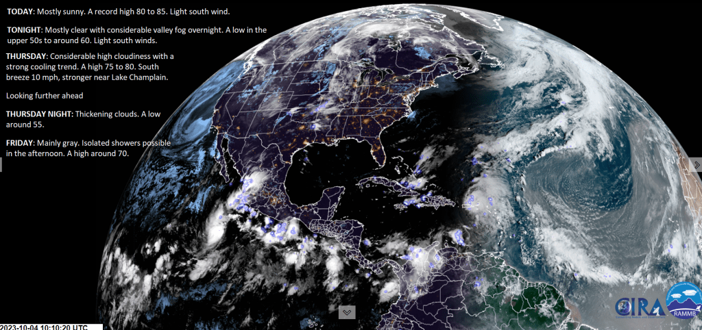
TODAY: Mostly sunny. A record high 80 to 85. Light south wind.
TONIGHT: Mostly clear with considerable valley fog overnight. A low in the upper 50s to around 60. Light south winds.
THURSDAY: Considerable high cloudiness with a strong cooling trend. A high 75 to 80. South breeze 10 mph, stronger near Lake Champlain.
Looking further ahead
THURSDAY NIGHT: Thickening clouds.A low around 55.
FRIDAY: Mainly gray.Isolated showers are possible in the afternoon. A high around 70.
SATURDAY: Overcast.Good chance for periods of rain or frequent showers, some moderate to briefly heavy with a rumble or two of thunder. A low in the low 60s. A high around 65.
SUNDAY: Morning clouds,. Chance for showers early, exiting in the afternoon give to a few breaks of afternoon sunshine. A low upper 40s to around 50. A high mid to upper 50s.
MONDAY: Clouds with intervals of sunshine.Scattered mountain sprinkles or brief showers. A low 40 to 45. A high in the mid-50s.
Average lows upper 30s to low 40s. Average highs upper 50s to lower 60s.
RH/10-4 forecast][end]
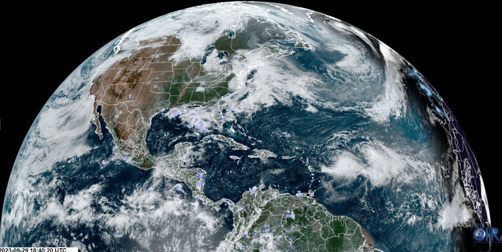
Blocking high pressure that has produced excellent dry weather days ends as a mini heatwave across the #GreenMountainState and greater #NewEngland. Excellent vacation weather is an understatement. But our reality this time of year is that colder outbreaks of weather are on the way, including clouds and generally grayer conditions than what we have been lucky to experience. Rain could come down rather hard, maybe even a little #thunder for Saturday, also some extra moisture from #Philippe.
TONIGHT: Brightly moonlit clouds with light showers south of the Barre-Montpelier area…exiting overnight with partial clearing northwestern areas. A low upper 40s to around 50. Little wind.
TOMORROW: High overcast gives way to increasing sun in the afternoon. A high in the low 70s. Light north winds.
SATURDAY NIGHT: Clear & moonlit. Patchy valley fog southern areas.A low in the mid 40s. Light north winds.
SUNDAY: Lots of sunshine with a couple afternoon clouds. A high in the mid 70s. Light north winds.
Looking further ahead
SUNDAY NIGHT: Mostly clear & partially moonlit with some high clouds.A low in the upper 40s.
MONDAY: Sunshine with few high clouds. A high 70 to 75.
TUESDAY: Lots of sunshine with a few clouds northern regions. A low 50 to 55. A high around 75.
WEDNESDAY: Mostly sunny and warm late summer-like highs. A low 50 to 55. A high 75 to 80.
Average lows upper 30s to mid 40s. Average highs 60 to 65.
Admin: off Monday and Tuesday back Wednesday
RH/9-29 forecast][end]
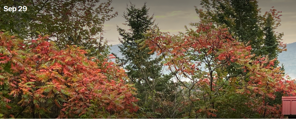
The transition to brilliant Fall-foliage was underway. Red Sumac living up to expectations in Worcester, Vermont. Fully expect a vibrant fall-color season in the Green Mountain State in the next two weeks.
