Updated Monday Evening forecast — October 2nd, 2017

TONIGHT: Mostly clear with a few high clouds. Patchy valley fog. A low in the low 40s. Light southeast winds.

TOMORROW: Partly to mostly sunny after morning fog. Warmer. A high around 70. South to southwest winds 10 to 15 mph.

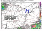
TUESDAY NIGHT: Mostly clear with a few high clouds. Patchy valley fog. A low in the mid 40s to near 50. South breeze 10 mph across the hills.

WEDNESDAY: Partly to mostly sunny after morning fog. More clouds late with a rising chance for showers far northern areas. Mild. A high in the mid 70s. South winds 10 to 15 mph.

Looking further ahead…

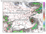
WEDNESDAY NIGHT: Mostly cloudy with a chance for showers, maybe a rumble of thunder in the evening. A low in the mid 50s.

THURSDAY: Partly to mostly cloudy. Turning cooler. A couple mountain sprinkles or brief showers possible early. A high in the mid to upper 60s.

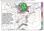
FRIDAY: Cloudy. Chance for showers mainly in the afternoon. A low around 45 to 50. A high in the mid 60s.

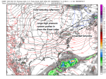
SATURDAY: Considerable morning fog burns off to partly sunny skies. A low in the mid to upper 40s A high in the low to mid 60s.

Average low in the low to mid 40s. Normal highs 60 to 65.

RH/10-2 [end]

Virus-free. www.avast.com

Updated Monday morning forecast — October 2nd, 2017

TODAY: Morning fog burns off to lots of sunshine, with a few high clouds. A high mid to upper 60s. Light south winds.

TONIGHT: Mostly clear with a few high clouds. Patchy valley fog. A low in the low 40s. Light southeast winds.

TUESDAY: Partly to mostly sunny after morning fog. Warmer. A high around 70. South to southwest winds 10 to 15 mph.

Looking further ahead…

TUESDAY NIGHT: Mostly clear with a few high clouds. Patchy valley fog. A low in the mid to upper 40s.

WEDNESDAY: Partly to mostly sunny after morning fog. More clouds late. Very mild. A high in the mid 70s.

THURSDAY: Mixed clouds and intervals of sun. Turning cooler. Scattered showers with a chance for an afternoon thunderstorm. A low 50 to 55. A high in the mid to upper 60s.

FRIDAY: Cloudy. Chance for showers mainly in the afternoon. A low around 45 to 50. A high in the low to mid 60s.

SATURDAY: Considerable morning fog burns off to partly sunny skies. A low around 40. A high in the upper 50s to low 60s.

Average low in the low to mid 40s. Normal highs 60 to 65.

RH/10-2 [end]

Virus-free. www.avast.com

Updated Friday evening forecast — September 29th, 2017

TONIGHT: Fair early then cloudy. A good chance for light showers late evening onward. A low 40 to 45. Light northeast winds.

TOMORROW: Considerable clouds with any leftover showers exiting early in the morning. Intervals of sun in the afternoon. Rather cool. A high in the mid 50s. North to northeast breeze 10 mph.

SATURDAY NIGHT: Mostly clear with considerable valley fog overnight. Widely scattered frost colder hollows A low in the mid 30s. Little wind.

SUNDAY: Bright autumn sun after morning fog. A high in the low 60s. Light west winds.

Looking further ahead…

SUNDAY NIGHT: Variable high cloudiness. A low in the upper 30s to around 40.

MONDAY: Mostly sunny. A high mid to upper 60s.

TUESDAY: Partly to mostly sunny after morning fog. Warmer. A low in the mid 40s. A high around 70.

WEDNESDAY: Partly to mostly sunny after morning fog. A low in the mid 40s. A high 70 to 75.

THURSDAY: Morning sunshine giving way to clouds. A little more muggy. Chance for afternoon showers, maybe a thunderstorm. A low 50 to 55. A high in the low to mid 70s.

Average low mid to upper 40s. Normal highs in the 60s

RH/9-29 [end]

Virus-free. www.avast.com

Updated Friday morning Forecast — September 29th, 2017

TODAY: Partly cloudy this morning northern areas. Mostly sunny this afternoon with more clouds arriving late western areas. Cool and a little breezy with a high in the upper 50s to low 60s. Northwest winds 10 to 15 mph.

TONIGHT: Mainly cloudy. A good chance for light shower activity arriving mid to late evening onward. A low ranging thru the 40s. Light northeast winds.

SATURDAY: Considerable morning clouds with leftover showers exiting out of the region. Mixe4d clouds and sun in the afternoon. Rather cool. A high 55 to 60. North to northeast breeze 10 mph.

Looking further ahead…

SATURDAY NIGHT: Mostly clear with considerable valley fog overnight. A low in the mid to upper 30s. Widely scattered frost colder hollows.

SUNDAY: Bright autumn sun after morning fog. A high in the low 60s.

MONDAY: Mostly sunny. A low in the upper 30s to low 40s. A high mid to upper 60s.

TUESDAY: Partly to mostly sunny after morning fog. Warmer. A low in the mid 40s. A high around 70.

WEDNESDAY: Partly to mostly sunny after morning fog. A low in the mid 40s. A high 70 to 75.

THURSDAY: Morning sunshine giving way to clouds. A little more muggy. Chance for afternoon showers, maybe a thunderstorm. A low 50 to 55. A high in the 70s.

Average low mid to upper 40s. Normal highs in the 60s

RH/9-29 [end]

Virus-free. www.avast.com

Updated Thursday Evening forecast — September 28th, 2017

TONIGHT: Scattered clouds. A low in the 40s. Northwest breeze 10 mph.

TOMORROW: More clouds northern areas in the morning, otherwise clouds giving way to increasing afternoon sunshine. Chilly and breezy with a high in the upper 50s to around 60. Northwest winds 10 to 15 mph.

FRIDAY NIGHT: Mainly cloudy. A good chance for showers mid to late evening on. A low in the 40s. Light northeast winds.

SATURDAY: Considerable morning clouds with leftover showers exiting. Partly cloudy in the afternoon. A high 55 to 60. North to northeast breeze 10 mph.

Looking further ahead…

SATURDAY NIGHT: Mostly clear with considerable valley fog overnight. A low in the mid to upper 30s. Widely scattered frost colder hollows.

SUNDAY: Bright autumn sun after morning fog. A high 60 to 65.

MONDAY: Mostly sunny. A low in the mid 30s to low 40s. A high 65 to 70.

TUESDAY: Partly to mostly sunny after morning fog. Warmer. A low in the mid 40s. A high around 70.

WEDNESDAY: Partly to mostly sunny after morning fog. A low in the mid 40s. A high in the mid 70s.

Average low mid to upper 40s. Normal highs in the 60s

RH/9-28 [end]

Virus-free. www.avast.com

Updated Thursday morning Forecast — September 28th, 2017

TODAY: Partly to mostly cloudy for a time northern areas, partly sunny Barre-Montpelier area south. Breezy, much cooler and less humid.A high in the low 60s. Northwest winds 10 to 20 mph.

TONIGHT: Partly cloudy. A low in the mid to upper 40s.Northwest breeze 10 mph.

FRIDAY: More clouds northern areas, Otherwise clouds giving way to periods of afternoon sunshine . Seasonally cool and breezy. A high 55 to 60. Northwest breeze 10 to 15 mph.

Looking further ahead…

FRIDAY NIGHT: Mainly cloudy with a rising chance for showers especially western and southern areas. A low 40 to 45.

SATURDAY: Considerable morning clouds with a few brief showers, giving way to intervals of sun in the afternoon. A high 55 to 60.

SUNDAY: Bright autumn sun after morning fog. A low in the mid to upper 30s. Isolated frost possible Northeast Kingdom. A high 60 to 65.

MONDAY: Mostly sunny. A low in the mid 30s to low 40s. A high in the mid 60s to near 70.

TUESDAY: Partly to mostly sunny skies. And warmer. A low 40 to 45. A high around 70.

Average low mid to upper 40s. Normal highs mid to upper 60s

RH/9-28 [end]

Virus-free. www.avast.com

Updated Wednesday morning Forecast — September 27th, 2017

TODAY: Mostly sunny much of today with more clouds northern areas late this afternoon where there could be an isolated late afternoon shower or thunderstorm N. Green Mountains. Muggy, but not as hot with a high in the mid 80s. Southwest winds 10 to 20 mph.

TONIGHT: Partly to mostly cloudy. Widely scattered showers and thunderstorms across northern areas. A low in the mid to upper 50s. Southwest breeze shifting to northwesterly overnight 10 mph.

THURSDAY: Partly to mostly cloudy for a time northern areas, partly sunny Barre-Montpelier area south. Breezy, much cooler and less humid.A high in the low 60s. Northwest winds 10 to 20 mph.

Looking further ahead…

THURSDAY NIGHT: Partly cloudy. A low in the 40s.

FRIDAY: Periods of morning sun giving way to more clouds at times. Seasonally cool and breezy. A high in the upper 50s to low 60s.

SATURDAY: Considerable morning clouds with a few brief showers, giving way to intervals of sun in the afternoon. A low 40 to 45. A high in the upper 50s to low 60s.

SUNDAY: Bright autumn sun after morning fog. A low 35 to 40. Isolated frost possible Northeast Kingdom. A high in the mid 60s.

MONDAY: Mostly sunny. A low in the mid 30s to low 40s. A high in the mid 60s to near 70.

TUESDAY: Partly to mostly sunny skies. And warmer. A low 40 to 45. A high around 70.

Average low mid to upper 40s. Normal highs mid to upper 60s

RH/9-27 [end]

Virus-free. www.avast.com

Updated Tuesday morning forecast — September 26th, 2017

TODAY: Filtered sunshine with some high clouds after morning fog burns off. Hot and sticky. A record high in the upper 80s to low 90s. Little wind.

TONIGHT: Mostly clear and muggy. A low 60 to 65. Little wind.

WEDNESDAY: Mostly sunny with more clouds late in the day. Maybe an isolated late afternoon shower or thundershower. Muggy and continued very warm becoming breezy. A high in the mid 80s. Southwest winds 10 to 20 mph.

Looking further ahead…

WEDNESDAY NIGHT: Variably cloudy. Widely scattered showers and thunderstorms. A low in the 50s.

THURSDAY: Isolated leftover mountain showers in the morning, Otherwise Partly to mostly cloudy for a time northern areas, partly sunny Barre-Montpelier area south. Breezy, much cooler and less humid.A high in the low 60s.

FRIDAY: Morning clouds, then partly sunny to mostly sunny in the afternoon . A low 40 to 45. A high 55 to 60.

SATURDAY: Sunshine mixed with cloudy periods. Slight chance for a few showers. A low around 40. A high near 60.

SUNDAY: Mostly sunny after morning fog. A low 35 to 40. Isolated frost possible Northeast Kingdom. A high in the mid 60s.

Average low mid to upper 40s. Normal highs mid to upper 60s

RH/9-26 [end]

Virus-free. www.avast.com

Updated Monday Evening forecast — September 25th, 2017

TONIGHT: Mostly clear with a few high clouds. Patchy valley fog. Muggy with a low 60 to 65. Light south winds.

TOMORROW: Filtered sunshine after morning fog burns off. Hot and sticky. A record high in the upper 80s to low 90s. Little wind.

TUESDAY NIGHT: Mostly clear and muggy. A low 60 to 65. Little wind.

WEDNESDAY: Mostly sunny with more clouds late in the day. Maybe an isolated late afternoon shower or thundershower. Muggy and continued very warm becoming breezy. A high in the mid 80s. Southwest winds 10 to 20 mph.

Looking further ahead…

WEDNESDAY NIGHT: Widely scattered showers and thunderstorms. A low in the 50s.

THURSDAY: Isolated leftover mountain showers in the morning, Otherwise mixed clouds and sun. Breezy, much cooler and less humid.A high in the low 60s.

FRIDAY: Mostly sunny. A low 40 to 45. A high 55 to 60.

SATURDAY: Sunshine mixed with cloudy periods. Slight chance for a few showers. A low around 40. A high near 60.

SUNDAY: Mostly sunny after morning fog. A low 35 to 40. Isolated frost possible Northeast Kingdom. A high in the mid 60s.

Average low mid to upper 40s. Normal highs mid to upper 60s

RH/9-25 [end]

Virus-free. www.avast.com

Updated Monday morning Forecast — September 25th, 2017

TODAY: Morning fog burns off to hazy sunshine. Sticky and hot. A record high in the upper 80s to low 90s. Light winds

TONIGHT: Mostly clear with a few high clouds. Patchy valley fog. Muggy with a low 60 to 65. Light south winds.

TUESDAY: Filtered sunshine after morning fog burns off. Hot and sticky. A record high in the upper 80s to low 90s. Little wind.

Looking further ahead…

TUESDAY NIGHT: Mostly clear and muggy. A low 60 to 65.

WEDNESDAY: Partly to mostly sunny with more clouds late. Muggy and continued very warm. A high in the mid to upper 80s.

THURSDAY: Isolated leftover mountain showers in the morning, Otherwise partly to mostly cloudy. Breezy , much cooler and less humid.A low 55 to 60. A high 60 to 65.

FRIDAY: Mixed clouds and sun. A low in the 40s. A high in the 50s.

Average low mid to upper 40s. Normal highs mid to upper 60s

RH/9-25 [end]

Virus-free. www.avast.com