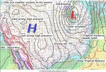
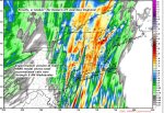
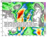
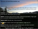
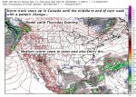
TONIGHT: Cloudy. Showers… moderate to heavy at times this evening, maybe a rumble of thunder, exiting overnight. Breezy at times this evening. A low in the mid to upper 50s. Southeast breeze 10 to 25 mph this evening gradually diminishing shifting southerly overnight.
TOMORROW: Clouds with a few breaks of sun. Scattered showers east of the Greens especially in the afternoon. A high 60 to 65. South winds 10 mph.
WEDNESDAY NIGHT: Mainly cloudy and damp with more showers likely.A low 40 to 45. Light winds.
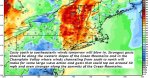
THURSDAY: Clouds, Scattered showers especially near the mountains. Much cooler. A high in the low 50s. Northwest winds 10 mph.
Looking further ahead…
THURSDAY NIGHT: Mostly cloudy and cool. Chance for leftover showers. A low 35 to 40.
FRIDAY: Morning clouds with a shower possible Northeast Kingdom, exiting to increasing amounts of sunshine into the afternoon. A high in the mid 50s.
SATURDAY: Mostly sunny with a few high clouds. A low 35 to 40. A high in the low 60s.
SUNDAY: Clouding up and turning breezy. Chance for showers.A low in the low to mid 40s. A high in the 50s.
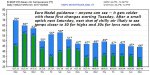
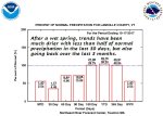
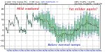
Average lows 30 to 35. Normal highs 50 to 55.
RH/10-24[end]
| Virus-free. www.avast.com |