Updated Thursday Evening Forecast — May 3rd, 2018

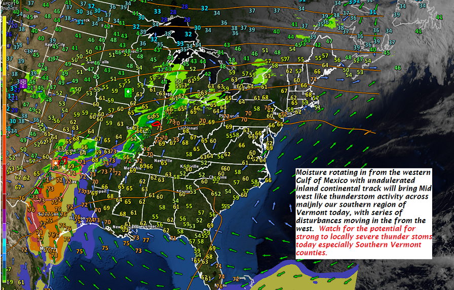
TONIGHT: Mainly cloudy. A round of showers this evening…some briefly heavy, maybe a rumble of thunder. A low 55 to 60. Light southwest winds.

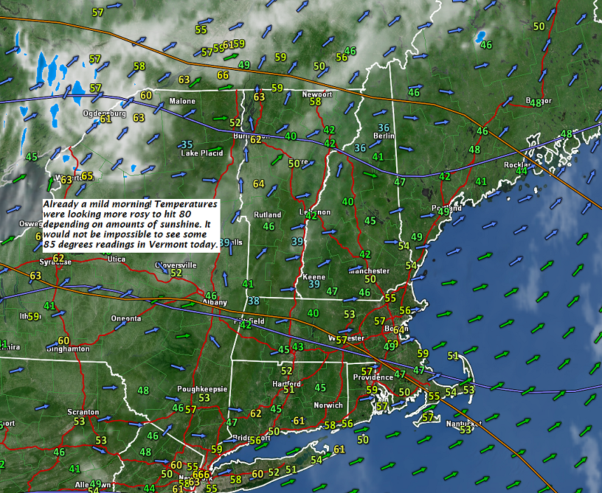
TOMORROW: Considerable morning cloudiness giving way to intervals of afternoon sun. Scattered showers and thunderstorms…some strong with locally gusty winds and hail. Becoming breezy. A high 70 to 75. Southwest winds 10 to 25 mph stronger late in the day.

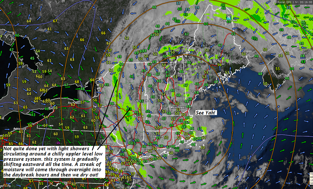
FRIDAY NIGHT: Partly to mostly cloudy. Showers and isolated thunderstorms winding down in the evening. Breezy to windy. A low in the mid to upper 40s. West winds 10 to 25 with higher gusts across the hills.

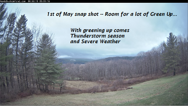
SATURDAY Green Up Day: Morning cloudiness and still breezy giving way to increasing sunshine. A high in the mid 60s. West northwest winds 10 to 25 mph.

Looking further ahead…

SATURDAY NIGHT: Mostly clear. Cooler. A low 40 to 45.

SUNDAY: Partly sunny. Slight chance for passing showers Sunday evening. A high 65 to 70.

MONDAY: Lots of sunshine but cooler. A low upper 30s to low 40s. A high 55 to 60.

TUESDAY: Sunny and gorgeous. A low 35 to 40. A high 65 to 70.

WEDNESDAY: Blue skies and bright sunshine. A low around 40. A high in the mid to upper 60s.

Average lows upper 30s to low 40s. Normal highs in the low to mid 60s.

RH/5-3-18[end]

Virus-free. www.avast.com

Updated Thursday Morning Forecast — May 3rd, 2018

TODAY: Maybe few hints of sun this morning. Otherwise clouding up. Showers becoming likely by late morning some briefly moderate to heavy with few rumbles of thunder Northern areas. Scattered showers and strong thunderstorms this afternoon across southern areas. Breezy. A high in the low 70s. Southwest winds 10 to 20 mph.

TONIGHT: Mainly cloudy. Showers likely with a chance for thunderstorms, some could be locally heavy. A low 55 to 60. Light southwest winds.

FRIDAY: Showers and thunderstorms…some strong with locally gusty winds and hail. Otherwise mostly cloudy & becoming breezy. A high 70 to 75. Southwest winds 10 to 25 mph stronger late in the day.

Looking further ahead…

FRIDAY NIGHT: Gradual clearing, but breezy to windy especially in the evening. A low in the 40s.

SATURDAY Green Up Day: Morning cloudiness giving way to filter sunshine. A high 65 to 70.

SUNDAY: Partly sunny. Slight chance for passing showers Sunday evening. A low 40 to 45. A high mid 60s to near 70.

MONDAY: Lots of sunshine. A low upper 30s to mid 40s. A high in the low 60s.

TUESDAY: Sunny and gorgeous. A low 35 to 40. A high 65 to 70.

WEDNESDAY: Blue skies and bright sunshine. A low around 40. A high in the mid to upper 60s.

Average lows upper 30s to low 40s. Normal highs in the low to mid 60s.

RH/5-3-18[end]

Virus-free. www.avast.com

Updated Wednesday Evening Forecast — May 2nd, 2018

TONIGHT: Rain showers for a time early to mid evening becoming isolated toward midnight. Otherwise cloudy periods. A low mid 50s to around 60. Southwest winds 10 to 15 mph.

TOMORROW: Partial morning sun, then more clouds. Showers likely. Chance for a few embedded thunderstorms in the afternoon…some locally heavy. Breezy. A high in the low 70s. Southwest winds 10 to 20 mph.

THURSDAY NIGHT: Mainly cloudy. Showers likely with a chance for thunderstorms. A low 55 to 60. Light southwest winds.

FRIDAY: Showers and a chance for thunderstorms…some potentially strong with locally gusty winds. Otherwise mostly cloudy & becoming breezy. A high 70 to 75. Southwest winds 10 to 25 mph

Looking further ahead…

FRIDAY NIGHT: Gradual clearing and breezy to windy in the evening. A low in the 40s.

SATURDAY Green Up Day: More sunshine than clouds. A high in the 60s.

SUNDAY: Partly to mostly sunny. A low upper 30s to low 40s. A high in the low to mid 60s.

MONDAY: Sunshine mixing with afternoon clouds. A low in the 30s with areas of frost possible. A high around 65.

TUESDAY: Sunshine mixed with afternoon clouds. A low 35 to 40. A high 65 to 70.

Average lows upper 30s to low 40s. Normal highs in the low to mid 60s.

RH/5-2-18[end]

Virus-free. www.avast.com

Updated Wednesday morning forecast — May 2nd, 2018

TODAY: Morning sun then more clouds this afternoon. Breezy and a touch humid. A high 75 to around 80. West to southwest winds 10 to 25 mph.

TONIGHT: Lots of clouds. Widely scattered showers. A low in the mid 50s. Southwest winds 10 to 20 mph.

THURSDAY: Partial morning sun, then more clouds. Showers likely with a few embedded thunderstorms possible, mainly in the afternoon…some locally heavy. Breezy. A high in the low 70s. West southwest winds 10 to 20 mph.

Looking further ahead…

THURSDAY NIGHT: Mainly cloudy. Showers likely with a chance for thunderstorms. A low in the mid 50s.

FRIDAY: Showers and a chance for thunderstorms…some potentially strong with gusty winds. Otherwise mostly cloudy & becoming breezy to windy late. A high near 70.

SATURDAY Green Up Day: Partly sunny. A low 40 to 45. A high in the mid to upper 60s.

SUNDAY: Partly to mostly sunny. A low upper 30s to low 40s. A high in the low to mid 60s.

MONDAY: Mostly sunny. A low in the 30s with areas of frost possible. A high low to mid 60s.

Average lows upper 30s to low 40s. Normal highs in the low to mid 60s.

RH/5-2-18[end]

Virus-free. www.avast.com

Updated Tuesday Morning forecast — May 1st, 2018

TODAY: Chance for a few rain showers passing through this morning . Otherwise, clouds mixing with lots of sunshine this afternoon. Warmer. A high in the low to mid 60s. Light northwest winds.

TONIGHT: Mostly clear. Patchy valley fog. A low in the 40s. Light southwest winds.

WEDNESDAY: Partly sunny. Chance for a late day shower. A touch of humidity and breezy in the afternoon. A high mid 70s to near 80. West to southwest winds 10 to 20 mph.

Looking further ahead…

WEDNESDAY NIGHT: Lots of clouds. Isolated showers or thunderstorms. A low in the mid 50s.

THURSDAY: Partial morning sun, then more clouds. A good chance for showers with possible afternoon thunderstorms. Breezy in the afternoon. A high mid 60s to around 70.

FRIDAY: Showers and a chance for thunderstorms…some heavy. Otherwise mostly cloudy. A low in the mid 50s. A high in the 60s.

SATURDAY: Partly sunny. A low near 45. A high 60 to 65.

SUNDAY: Partly to mostly sunny. A low mid 30s possible frost. A high low to mid 60s.

Average lows upper 30s to low 40s. Normal highs in the low to mid 60s.

RH/5-1-18[end]

Updated Monday Evening forecast — April 30th, 2018

TONIGHT: Lots of clouds. Widely scattered light showers early this evening. More rain showers likely again overnight. Areas of fog. A low around 40. Light west winds.

TOMORROW: Maybe a leftover rain shower early. Otherwise, clouds with periods of sunshine with chance for sprinkle late. Warmer. A high 60 to 65. Light northwest winds.

TUESDAY NIGHT: Scattered clouds. Patchy valley fog. A low 40 to 45. Light southwest winds.

WEDNESDAY: Partly sunny. Chance for a late day shower. A touch of humidity and breezy in the afternoon. A high around 75. West to southwest winds 10 to 25 mph.

Looking further ahead…

WEDNESDAY NIGHT: Lots of clouds. A low in the mid 50s.

THURSDAY: Partial morning sun, then more clouds. A good chance for showers and possible thunderstorms late afternoon. A bit on the muggy side. Breezy in the afternoon. A high 70 to 75.

FRIDAY: Showers and a chance for thunderstorms…some heavy. Otherwise mostly cloudy. A low in the mid 50s. A high in the 60s.

SATURDAY: Partly sunny. A low near 45. A high 60 to 65.

SUNDAY: Partly to mostly sunny. A low around 40. A high in the 60s.

Average lows upper 30s to low 40s. Normal highs in the low to mid 60s.

RH/4-30[end]

Updated Monday morning Forecast — April 30th, 2018

TODAY: Mainly cloudy. A few breaks of sun this afternoon. Scattered wet snow showers winding down this morning . Rain showers likely again this afternoon. A high mid 40s to around 50. Northwest winds 10 mph this afternoon.

TONIGHT: Lots of clouds. A few rain showers likely again especially overnight. Areas of fog. A low around 40. Light west winds.

TUESDAY: Maybe a leftover rain shower this morning. Increasing sunshine in the afternoon and much warmer. A high in the low to mid 60s. Light northwest winds.

Looking further ahead…

TUESDAY NIGHT: Mostly clear. Patchy valley fog. A low around 45.

WEDNESDAY: Morning sunshine then thickening clouds. A rising chance for a late day shower, maybe rumbles of thunder far northern areas late. Becoming a bit humid. A high mid 70s to around 80.

THURSDAY: Mixed clouds and sun in the morning. A good chance for showers and possible thunderstorms in the afternoon. Somewhat muggy. A low in the mid to upper 50s. A high in the low to mid 70s.

FRIDAY: Showers and a chance for thunderstorms…some heavy. Otherwise mostly cloudy. A low 55 to 60. A high around 70.

Average lows upper 30s to low 40s. Normal highs in the low to mid 60s.

RH/4-30[end]

Updated Friday Evening Forecast — April 27th, 2018

TONIGHT: Mainly cloudy. Continued showery tapering off overnight. A low about 45. Light southeast winds.

TOMORROW: Clouds mixing with intervals of sun. Scattered rain showers developing in the afternoon. A high in the low 60s. Southwest winds 10 to 20 mph.

SATURDAY NIGHT: Cloudy. Periods of light rain likely. Areas of fog. A low near 40. Light southeast winds.

SUNDAY: Gray skies. Rain showers…mixed with a few wet snow flakes high terrain in the morning. Raw with a high around 45. Light west winds.

Looking further ahead…

SUNDAY NIGHT: Mainly cloudy, maybe a leftover evening shower. A low 32 to 35.

MONDAY: Considerable cloudiness. Widely scattered sprinkles. A high 45 to 50.

TUESDAY: Partly to mostly cloudy and turning warmer.. A low around 40. A high upper 50s to low 60s.

WEDNESDAY: Sunshine gives way to afternoon cloudiness. Chance for late day showers. A low around 40. A high around 75.

THURSDAY: More clouds than sun. Widely scattered showers. Maybe a rumble of thunder. A low in the 50s. A high 65 to 75.

Average lows upper 30s to around 40. Normal highs in the in the low 60s.

RH/4-27[end]

Virus-free. www.avast.com

Updated Friday morning forecast — April 27th, 2018

TODAY: Filtered sun early then thickening clouds. Light rain arriving early to mid afternoon. A high in the mid 50s. South breeze 10 to 15 mph.

TONIGHT: Mainly cloudy. Continued showery tapering off overnight. A low 40 to 45. Light southeast winds.

SATURDAY: Clouds mixing with intervals of sun. Scattered rain showers developing in the afternoon. A high in the low to mid 60s. Southwest winds 10 to 15 mph.

Looking further ahead…

SATURDAY NIGHT: Mostly cloudy. Chance for a shower. A low 40 to 45.

SUNDAY: Mainly gray with scattered rain showers mixed with a few mountain top snowflakes. Colder with a high around 45.

MONDAY: Considerable cloudiness. Chance for more showers. A low mid 30s. A high 45 to 50.

TUESDAY: Lots of clouds. Scattered rain showers. A low 35 to 40. A high mid 40s to low 50s.

WEDNESDAY: Partly to mostly sunny. A low 35 to 40. A high reaching into the mid 70s.

Average lows upper 30s to around 40. Normal highs in the in the low 60s.

RH/4-27[end]

Virus-free. www.avast.com

Updated Thursday Evening forecast — April 26th, 2018

TONIGHT: A few leftover showers exiting northern areas this evening. Otherwise becoming partly cloudy. Patchy river valley fog. A low 35 to 40. Light southwest winds.

TOMORROW: Considerable cloudiness. Occasional light showers especially in the afternoon. A high in the mid 50s. South breeze 10 to 15 mph.

FRIDAY NIGHT: Mainly cloudy. Continued showery. A low 40 to 45. Light southeast winds.

SATURDAY: Clouds mixing with intervals of sun. Scattered rain showers developing in the afternoon. A high in the low to mid 60s. Southwest winds 10 to 15 mph.

Looking further ahead…

SATURDAY NIGHT: Mostly cloudy. Chance for a shower. A low 35 to 45.

SUNDAY: Mainly gray with scattered rain showers. A high in the 50s.

MONDAY: Considerable cloudiness. Chance for more showers. A low mid 30s. A high 45 to 50.

TUESDAY: Lot5s of clouds with scattered rain showers. A low 35 to 40. A high mid 40s to low 50s.

Average lows upper 30s to around 40. Normal highs in the in the low 60s.

RH/4-26[end]

Virus-free. www.avast.com