Updated Thursday morning Forecast — May 31st, 2018

TODAY: Sunshine gives way to cloudy periods this afternoon.Warm and becoming rather muggy late today. A high 80 to 85. South breeze 10 to 20 mph.

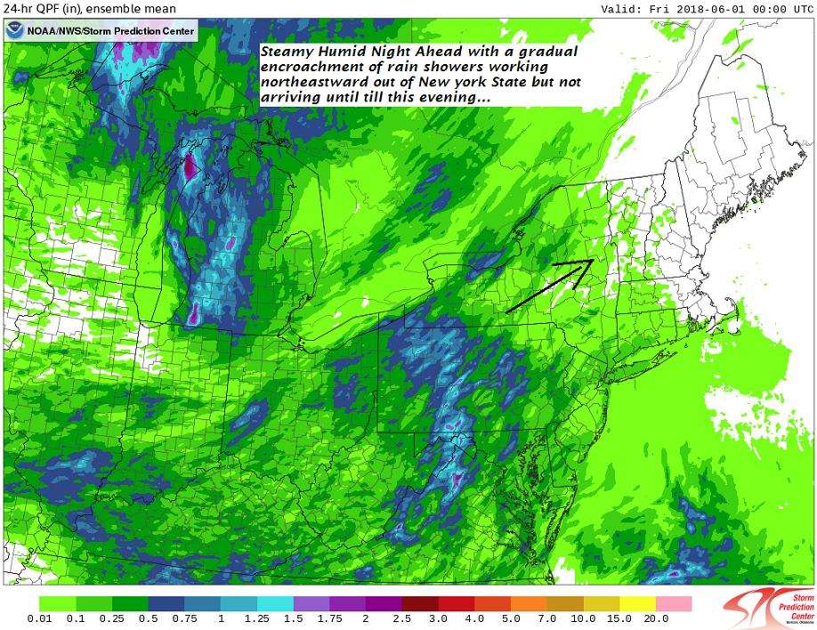
TONIGHT: Cloudy. An occasional shower or two developing this evening . Sultry and uncomfortable. A low in the mid to upper 60s. South winds 10 mph.

FRIDAY: Morning cloudiness then intervals of sun. Scattered showers and afternoon thunderstorms… some locally heavy. Sticky. A high 75 to 80. Light southwest winds.

Looking further ahead…

FRIDAY NIGHT: Considerable cloudiness. Chance for a few leftover showers or thunderstorms winding down. A low 55 to 60.

SATURDAY: Morning cloudiness, followed by mostly sunny afternoon. A high low 70s.

SUNDAY: Mostly sunny. A low mid 40s to upper 40s. A high 70 to 75.

MONDAY: Morning fog burns off with intervals of sun. Increasing afternoon clouds leading to a slight chance for late day showers.. A low 40 to 45. A high low to mid 60s.

TUESDAY: Mostly gray with a chance for showers. Rather cool and early spring-like A low in the low to mid 40s. A high 55 to 60.

Average lows upper 40s to mid 50s, normal highs upper 60s to mid 70s

RH/5-31[end]

Virus-free. www.avast.com

Updated Wednesday Evening Forecast — May 30th, 2018

TONIGHT: Clear and moonlit. A low in the low to mid 50s. Light south winds.

TOMORROW: Sunshine gives way to cloudy periods in the afternoon.Warm and becoming humid. A high 80 to 85. South breeze 10 to 20 mph.

THURSDAY NIGHT: Cloudy. A good chance for showers especially later in the evening and overnight. Muggy. A low 60 to 65. South winds 10 mph.

FRIDAY: Morning cloudiness then partly sunny. Scattered afternoon showers and thunderstorms some locally heavy. Sticky. A high around 80. Light southwest winds.

Looking further ahead…

FRIDAY NIGHT: Chance for a few leftover showers or thunderstorms exiting to partial clearing. A low 55 to 60.

SATURDAY: Considerable morning cloudiness, then partial clearing. A high in the 70s.

SUNDAY: Mixed clouds and sunshine, but dry. A low mid 40s to near 50. A high around 75.

MONDAY: Morning fog burns off with intervals of sun. Increasing afternoon clouds leading to a chance for showers. A low 40 to 45. A high in the mid 60s to around 70.

Average lows upper 40s to low 50s, normal highs upper 60s to low 70s

RH/5-30[end]

Virus-free. www.avast.com

Updated Wednesday morning Forecast — May 30th, 2018

TODAY: Mostly sunny and very pleasant. A high upper 70s to low 80s. South breeze 10 to 15 mph in the afternoon.

TONIGHT: Clear and moonlit. A low upper 40s to mid 50s. Light south winds.

THURSDAY: Sunshine gives way to few more afternoon cloud.Increasingly more humid in the afternoon and summer-like. A high 80 to 85. South breeze 10 to 20 mph.

Looking further ahead…

THURSDAY NIGHT: Increasing clouds. Rising chance for showers overnight. Muggy. A low 60 to 65.

FRIDAY: Morning cloudiness then partly sunny. Scattered afternoon and evening showers and thunderstorms. Sticky. A high in the upper 70s to lower 80s.

SATURDAY: Considerable morning cloudiness, with slight chance for showers toward southern areas, then partial clearing. A low mid 50s to around 60. A high in the 70s.

SUNDAY: Mixed clouds and sunshine, but dry. A low in the 50s. A high in the 70s.

MONDAY: Morning fog burns off to partial sunshine. A low in the 40s. A high 70 to 75.

Average lows upper 40s to low 50s, normal highs upper 60s to low 70s

RH/5-30[end]

Virus-free. www.avast.com

Updated Tuesday Evening forecast — May 29th, 2018

TONIGHT: Mostly clear and fully moonlit with patchy valley fog. A low mid 40s to low 50s. Light east winds.

TOMORROW: Sunny, but with a few high clouds. Pleasant. A high upper 70s to around 80. South breeze 10 to 15 mph in the afternoon.

WEDNESDAY NIGHT: Mostly clear. Isolated valley fog. A low 50 to 55. South breeze 10 mph.

THURSDAY: Sunshine gives way to late afternoon cloudiness. Increasingly more humid. A high around 80. South breeze 10 to 20 mph.

Looking further ahead…

THURSDAY NIGHT: Cloudy. Rising chance for showers mid evening on. Muggy A low in the low 60s.

FRIDAY: Morning cloudiness then partly sunny. Scattered afternoon and evening showers and thunderstorms. Sticky. A high in the upper 70s to lower 80s.

SATURDAY: Considerable morning clouds then intervals of sunshine. Scattered showers and afternoon thunderstorms. A low around 60. A high 75 to 80.

SUNDAY: Mostly cloudy. Chance for showers. A low in the 50s. A high in the 70s.

Average lows upper 40s to low 50s, normal highs upper 60s to low 70s

RH/5-29[end]

Virus-free. www.avast.com

Updated Tuesday morning Forecast — May 29th, 2018

Full Flower Moon 10:20 AM

TODAY A few lingering morning clouds, then sunny and gorgeous. A high mid to upper 70s. North breeze 10 to 15 mph in the afternoon.

TONIGHT: Mostly clear with patchy valley fog. A low mid 40s to low 50s. Light east winds.

WEDNESDAY: Sunny a few high clouds. Pleasant. A high near 80. South breeze 10 to 15 mph.

Looking further ahead…

WEDNESDAY NIGHT: Mostly clear. Isolated valley fog. A low around 55.

THURSDAY: Partly to mostly sunny Sunshine gives way to afternoon cloudiness. Warmer and more summer-like. A high 80 to 85.

FRIDAY: Morning cloudiness then partly sunny. Scattered afternoon and evening showers and thunderstorms. Sticky. A low 60 to 65. A high in the low to mid 80s.

SATURDAY: Considerable morning clouds then intervals of sunshine. Scattered showers and afternoon thunderstorms. A low 60 to 65. A high around 80.

SUNDAY: Mostly cloudy. Chance for showers. A low in the 50s. A high in the 70s.

Average lows upper 40s to low 50s, normal highs upper 60s to low 70s

RH/5-29[end]

Virus-free. www.avast.com

Updated Memorial Day Morning forecast — May 28th, 2018

TODAY: Cloudy with a few intervals of sun. Widely scattered showers. A high around 75. Southwest winds 10 to 15 mph.

TONIGHT: Chance for a few showers northern areas otherwise partially moonlit skies. Patchy valley fog. Humid with a low in the mid 50s to low 60s. Light southwest winds.

Full Flower Moon occurs at 10:20 AM Tuesday

TUESDAY: A few lingering clouds then sunny and gorgeous. A high 70 to 75. North to northwest winds 10 to 15 mph in the afternoon.

Looking further ahead…

TUESDAY NIGHT: Mostly clear with patchy valley fog. A low 45 to 50.

WEDNESDAY: Sunny a few high clouds. Pleasant. A high pushing near 80.

THURSDAY: Sunshine gives way to afternoon cloudiness with a rising chance for showers and possible thunderstorms. Warmer eventually more muggy. A low around 55. A high 80 to 85.

FRIDAY: Morning clouds then partly sunny and sticky. Scattered afternoon and evening showers and thunderstorms. A low in the low to mid 60s. A high ranging through the 80s.

Average lows upper 40s to low 50s, normal highs upper 60s to low 70s

RH/5-28[end]

Virus-free. www.avast.com

Updated Friday Evening Forecast — May 25th, 2018

TONIGHT: Showers likely overnight northern areas. Maybe a rumble or two of thunder. Otherwise cloudy and kind of humid. A low upper 50s to mid 60s. Light southwest winds.

TOMORROW: Sun mixed with cloudy periods. Showers northern areas in the morning, tracking southward into the afternoon with a chance for a few thunderstorms. A high in the mid 70s. North to northwest breeze 10 mph.

SATURDAY NIGHT: Chance for shower or storm south of the Barre-Montpelier area. Otherwise mostly cloudy. Patchy valley fog. A low ranging through the 50s. Light east winds.

SUNDAY: More clouds than sunshine. Maybe an isolated shower. A high in the 60s. Southeast breeze 10 to 15 mph.

Looking further ahead…

SUNDAY NIGHT: Considerable low cloudiness, damp and cool. A low 45 to 50.

MONDAY Memorial Day: Mostly cloudy. Chance for showers & thunderstorms arriving toward evening especially northern areas. A high near 70

TUESDAY: Sunny and gorgeous after morning fog. A low in the 50s. A high in the low 70s.

WEDNESDAY: Mostly sunny. Pleasant. Lows in the 40s. A high pushing near 80.

THURSDAY: Sunshine gives way to high cloudiness. Warmer. A low 55 to 60. A high 80 to 85.

Average lows upper 40s to low 50s, normal highs upper 60s to low 70s

RH/5-25[end]

Virus-free. www.avast.com

Updated Friday morning forecast — May 25th, 2018

TODAY: Partly to mostly sunny and warmer much of today. More clouds this afternoon with a slight chance for shower Champlain valley late. A high upper 70s to low 80s. West breeze 10 to 25 mph this afternoon.

TONIGHT: Showers becoming likely late evening on especially northern areas. Otherwise lots of clouds. Not as cool. A low upper 50s to mid 60s. Light southwest winds.

SATURDAY: Sun mixed with cloudy periods. Showers northern areas in the morning. Muggy with a chance for an afternoon shower or thunderstorm especially southern areas. A high in the mid to upper 70s. North to northwest breeze 10 mph.

Looking further ahead…

SATURDAY NIGHT: Slight chance for shower or storm far southern areas. otherwise partly to mostly cloudy. Patchy valley fog. A low in the 50s.

SUNDAY: More clouds than sunshine. Maybe an isolated shower. A high in the low 70s.

MONDAY Memorial Day: Mostly cloudy. Chance for showers & thunderstorms arriving toward evening. A low around 50. A high 70 to 75.

TUESDAY: Sunny and gorgeous after morning fog. A low in the 50s. A high in the low 70s..

WEDNESDAY: Partly to mostly sunny. Pleasant. Lows in the 40s. A high in the low 80s.

Average lows upper 40s to low 50s, normal highs upper 60s to low 70s

RH/5-25[end]

Virus-free. www.avast.com

Updated Thursday Evening Forecast — May 24th, 2018

TONIGHT: Clear & starlit skies. A low upper 40s to mid 50s. Light southwest winds.

TOMORROW: Partly sunny giving way to more clouds late. Rising chance for late day showers northern Champlain Valley. A high upper 70s to near 80. West winds 10 to 20 mph.

FRIDAY NIGHT: Chance for showers Barre-Montpelier area north. Otherwise mostly cloudy. Patchy valley fog. Not as cool. A low upper 50s to around 60. Light southwest winds.

SATURDAY: Mixed sun and clouds and more humid. Scattered showers…with a chance for late day and evening thunderstorms. A high around 75. Light north to northwest winds.

Looking further ahead…

SATURDAY NIGHT: An evening shower or thunderstorm, otherwise partly to mostly cloudy. A low in the 50s.

SUNDAY: More clouds than sun. An isolated shower or two.. A high 70 to 75.

MONDAY Memorial Day: Rather gray. A lingering chance for a few showers. Chance for thunderstorms toward evening. A low 45 to 50. A high upper 60s to near 70.

TUESDAY: Sunny and gorgeous after morning fog. A low in the 50s. A high in the low 70s..

WEDNESDAY: Partly to mostly sunny. Pleasant. Lows in the 40s. A high in the low 80s.

Average lows upper 40s to low 50s, normal highs upper 60s to low 70s

RH/5-24[end]

Virus-free. www.avast.com

Updated Thursday morning Forecast — May 24th, 2018

TODAY: A few clouds at times but otherwise mostly sunny and pleasant. A high upper 60s to low 70s. West to northwest breeze 10 to 15 mph.

TONIGHT: Clear & starlit skies giving way to few high clouds. A low 50 to 55. Light winds.

FRIDAY: Sunshine gives way to afternoon cloudiness. Rising chance for late day showers northern Champlain Valley. A high of about 80. West winds 10 to 15 mph.

Looking further ahead…

FRIDAY NIGHT: Mostly cloudy. Chance for showers Barre-Montpelier area north. Patchy valley fog. Not as cool. A low 55 to 60.

SATURDAY: Mixed sun and clouds and more humid. Scattered showers…with a chance for late day and evening thunderstorms. A high 75 to 80.

SUNDAY: Mostly cloudy. Widely scattered showers. A slight risk for a thunderstorm toward western Vermont. A low around 60. A high mid to upper 70s.

MONDAY Memorial Day: Rather gray. A lingering chance for a few showers. Chance for thunderstorms toward evening. A low 50 to 55. A high 65 to 70.

TUESDAY: Sunny and gorgeous after morning fog. A low in the 50s. A high pushing to near 70.

WEDNESDAY: Partly to mostly sunny. Pleasant. Lows in the 40s. A high in the 70s.

Average lows mid 40s to low 50s, normal highs mid 60s to low 70s

RH/5-24[end]

Virus-free. www.avast.com