Updated Tuesday Evening Forecast — June 5th, 2018

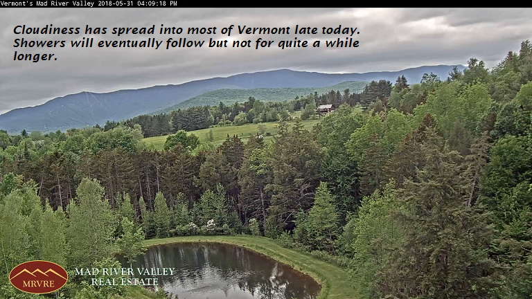
TONIGHT: Considerable cloudiness. Scattered showers early this evening winding down.A low in the mid to upper 40s. Light northwest winds.

TOMORROW: Clouds with break or two of sun. Scattered showers. A high 60 to 65. Northwest winds 10 mph.

WEDNESDAY NIGHT: Partly cloudy, then increasing clouds leading to a chance for showers toward daybreak. Patchy valley fog. A low 45 to 50. Light northwest winds.

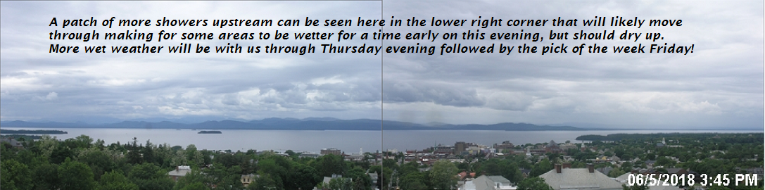
THURSDAY: Considerable cloudiness.Chance for showers. A high near 70. Northeast winds 10 mph.

Looking further ahead…

THURSDAY NIGHT: Cloudy periods. Chance for a round of showers. A low 50 to 55.

FRIDAY: Pick of the week. Morning clouds then mostly sunny. A high 65 to 70.

SATURDAY: Partly to mostly sunny. A low 45 to 50. A high around 70.

SUNDAY: Sunshine with a few more afternoon clouds. A low in the 40s. A high in the low 70s.

MONDAY: Partly sunny. Slight risk for an afternoon shower. A low in the 40s. A high in the mid to upper 60s.

Average lows 50 to 55, normal highs 70 to 75.

RH/6-5[end]

Updated Tuesday morning Forecast — June 5th, 2018

TODAY: Clouds with a couple sunny breaks now and then. Continued chilly and damp. Occasional showers. A high 55 to 60. Light northwest winds.

TONIGHT: Cloudy. Chance for showers.A low in the mid to upper 40s. Light northwest winds.

WEDNESDAY: Clouds with break or two of sun. Isolated to widely scattered showers. A high 60 to 65. North winds 10 mph.

Looking further ahead…

WEDNESDAY NIGHT: Partly cloudy. Patchy valley fog. A low 45 to 50.

THURSDAY: Considerable cloudiness.Slight chance for a shower. A high mid 60s to near 70.

FRIDAY: Pick of the week. Partly to mostly sunny. A low around 55. A high 65 to 70..

SATURDAY: Sunshine gives way to high cloudiness. A low 45 to 50. A high around 70.

SUNDAY: More clouds than sun. Chance for showers especially southern areas. A low in the 50s. A high in the low to mid 70s.

Average lows upper 40s to mid 50s, normal highs 70 to 75.

RH/6-5[end]

Updated Monday Evening Forecast — June 4th, 2018

TONIGHT: Mostly cloudy. Showers this evening exiting overnight. Areas of fog and drizzle. A low in the mid to upper 40s. Light south winds..

TOMORROW: Continued gray and damp. Occasional showers. A high 55 to 60. Light northwest winds.

TUESDAY NIGHT: Cloudy. Chance for showers.A low in the upper 40s to low 50s. Light northwest winds.

WEDNESDAY: Clouds with break or two of sun. Isolated to widely scattered showers. A high in the mid 60s. North winds 10 mph.

Looking further ahead…

WEDNESDAY NIGHT: Partly cloudy. Patchy valley fog. A low in the mid 40s.

THURSDAY: Considerable cloudiness.Slight chance for a shower. A high around 65.

FRIDAY: Pick of the week. Partly to mostly sunny. A low in the mid 50s. A high 70 to 75.

SATURDAY: Sunshine gives way to high cloudiness. A low 45 to 50. A high in the mid 70s.

SUNDAY: More clouds than sun. Chance for showers especially southern areas. A low in the 50s. A high in the low 70s.

Average lows upper 40s to mid 50s, normal highs 70 to 75.

RH/6-4[end]

test 4 Updated Monday morning Forecast — June 4th, 2018

TODAY: Gray skies with showers this morning becoming widely scattered this afternoon. Areas of fog. A high in the low 50s. Southeast winds 10 to 15 mph.

TONIGHT: Mostly cloudy. Showers this evening exiting overnight. Areas of fog. A low in the mid to upper 40s. South winds 10 mph.

TUESDAY: Mainly cloudy. An occasional light shower. A high in the upper 50s to low 60s. Light west winds.

Looking further ahead…

TUESDAY NIGHT: Cloudy. Chance for showers.A low in the upper 40s.

WEDNESDAY: Mostly cloudy. Widely scattered showers. A high 60 to 65.

THURSDAY: Mostly cloudy.Slight chance for a shower. A low upper 30s to mid 40s. A high 65 to 70.

FRIDAY: Partly sunny. A low in the mid 50s. A high around 70.

Average lows upper 40s to mid 50s, normal highs 70 to 75.

RH/6-4[end]

test2 Updated Monday morning Forecast — June 4th, 2018

TODAY: Gray skies with showers this morning becoming widely scattered this afternoon. Areas of fog. A high in the low 50s. Southeast winds 10 to 15 mph.

TONIGHT: Mostly cloudy. Showers this evening exiting overnight. Areas of fog. A low in the mid to upper 40s. South winds 10 mph.

TUESDAY: Mainly cloudy. An occasional light shower. A high in the upper 50s to low 60s. Light west winds.

Looking further ahead…

TUESDAY NIGHT: Cloudy. Chance for showers.A low in the upper 40s.

WEDNESDAY: Mostly cloudy. Widely scattered showers. A high 60 to 65.

THURSDAY: Mostly cloudy.Slight chance for a shower. A low upper 30s to mid 40s. A high 65 to 70.

FRIDAY: Partly sunny. A low in the mid 50s. A high around 70.

Average lows upper 40s to mid 50s, normal highs 70 to 75.

RH/6-4[end]

Updated Friday Evening forecast — June 1st, 2018

TONIGHT: Widely scattered showers and thunderstorms… one or two locally heavy to wind down this evening. Otherwise cloudy periods. A low in the upper 50s to low 60s. Light north winds.

TOMORROW: Morning clouds then mostly sunny and pleasant. A high around 75. North winds picking up 10 to 20 mph.

SATURDAY NIGHT: Mostly clear and partially moonlit. A low around 45. Light northeast winds.

SUNDAY: Mostly sunny with some high cloudiness. A high in the mid 70s. Light winds.

Looking further ahead…

SUNDAY NIGHT: Clear early, then clouding up. A rising chance for a shower overnight. A low around 40.

MONDAY: Mainly cloudy. Scattered showers eventually exiting in the afternoon. A high in the 50s.

TUESDAY: Gray. Chance for periods of rain or showers. A low 40 to 45. A high in the 50s.

WEDNESDAY: Mostly cloudy. Chance for showers. A low 45 to 50. A high 60 to 65.

THURSDAY: Mostly sunny. A low upper 30s to mid 40s. A high 70 to 75.

Average lows upper 40s to mid 50s, normal highs upper 60s to mid 70s

RH/6-1[end]

Virus-free. www.avast.com

Updated Friday morning Forecast — June 1st, 2018

TODAY: Morning cloudiness then intervals of sun. Scattered showers and afternoon thunderstorms… some locally heavy. Sticky. A high around 80. Light southwest winds.

TONIGHT: Considerable cloudiness. Chance for a few leftover showers or thunderstorms winding down. A low around 60. Light northwest winds.

SATURDAY: Morning cloudiness, followed by a mostly sunny afternoon. A high low to mid 70s. North winds picking up 10 to 20 mph.

Looking further ahead…

SATURDAY NIGHT: Mostly clear and partially moonlit. A low around 45.

SUNDAY: Mostly sunny with some high cloudiness. A high in the mid 70s.

MONDAY: Mainly cloudy. Widely scattered showers. A low 45 to 50. A high 60 to 65.

TUESDAY: Gray. Chance for periods of rain or showers. A low 40 to 45. A high mid 50s to low 60s

WEDNESDAY: Mostly cloudy. Chance for showers. A low 45 to 50. A high mid to upper 50s.

THURSDAY: Mostly sunny. A low upper 30s to mid 40s. A high mid 60s to low 70s.

Average lows upper 40s to mid 50s, normal highs upper 60s to mid 70s

RH/6-1[end]

Virus-free. www.avast.com

Updated Thursday Evening Forecast — May 30th, 2018

TONIGHT: Cloudy. An occasional shower or two developing this evening . Sultry and uncomfortable. A low ranging through the 60s. South winds 10 mph.

TOMORROW: Morning cloudiness then intervals of sun. Scattered showers and afternoon thunderstorms… some locally heavy. Sticky. A high 75 to 80. Light southwest winds.

FRIDAY NIGHT: Considerable cloudiness. Chance for a few leftover showers or thunderstorms winding down. A low around 60. Light northwest winds.

SATURDAY: Morning cloudiness, followed by a mostly sunny afternoon. A high low to mid 70s. North winds picking up 10 to 20 mph.

Looking further ahead…

SATURDAY NIGHT: Mostly clear and partially moonlit. A low 45 to 50.

SUNDAY: Mostly sunny with some high cloudiness. A high in the low 70s.

MONDAY: Mainly cloudy. Chance for showers. A low around 40. Rather cool and early spring-like A high around 50

TUESDAY: Mostly gray with a chance for lingering showers. A low around 40. A high 50 to 55.

Average lows upper 40s to mid 50s, normal highs upper 60s to mid 70s

RH/5-31[end]

Virus-free. www.avast.com