Updated Monday evening Forecast — July 9th, 2018

TONIGHT: Mostly clear with a few more clouds overnight. A low in the lower 60s. Light southwest winds.

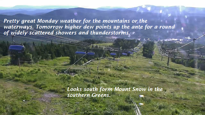
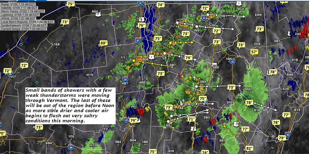
TOMORROW: Partly sunny. Widely scattered afternoon showers and thunderstorms. A high upper 70s to low 80s. Northwest breeze 10 to 15 mph.

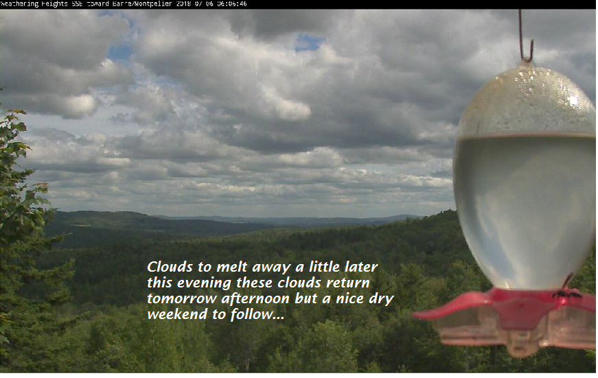
TUESDAY NIGHT: Partly cloudy. A low upper 50s to around 60. Light north wind.

WEDNESDAY: Lots of sunshine, more clouds across southern areas. A high mid 70s. North to northwest breeze 10 to 15 mph.

Looking further ahead…

WEDNESDAY NIGHT: Clear and starlit skies. Comfortable with a low around 50.

THURSDAY: Morning sunshine mixing with clouds. A high mid 70s to near 80.

FRIDAY: Morning sunshine followed by afternoon clouds. A low around 55. A high mid 80s

SATURDAY: Partly to mostly sunny. Slight chance for a afternoon shower or thunderstorm. A low 60 to 65. A high 85 to 90.

Average lows in the mid 50s to around 60, Normal highs in the upper70s to low 80s.

RH/7-9[end]

Virus-free. www.avast.com

Updated Monday morning Forecast — July 9th, 2018

TODAY: Sunny and warm. A high in the mid to upper 80s. Southwest breeze 10 to 20 mph in the afternoon.

TONIGHT: Becoming partly cloudy. A low 60 to 65. Light southwest winds.

TUESDAY: Clouds mixed with sun. Widely scattered afternoon showers and thunderstorms. A high in the lower 80s. Northwest breeze 10 to 20 mph.

Looking further ahead…

TUESDAY NIGHT: Partly cloudy. A low 55 to 60.

WEDNESDAY: Lots of sunshine, more clouds across southern areas. A high 75 to 80.

THURSDAY: Mixed clouds and sunshine. A low 50 to 55. A high around 80.

FRIDAY: Morning sunshine followed by afternoon clouds. A low 50 to 55. A high mid to upper 80s.

SATURDAY: Partly to mostly sunny. Slight chance for a afternoon shower or thunderstorm. A low 60 to 65. A high mid 80s.

Average lows in the mid 50s to around 60, Normal highs in the upper70s to low 80s.

RH/7-9[end]

Virus-free. www.avast.com

Updated Friday Evening forecast — July 6th, 2018

TONIGHT: Clear & starlit and comfortable. A low upper 40s to around 50. Light northwest winds.

TOMORROW: Morning sunshine then afternoon cloudiness. Refreshingly cooler. A high around 75. Northwest winds 10 to 20 mph in the afternoon.

SATURDAY NIGHT: Clear and starlit. A low 50 to 55. Light south winds.

SUNDAY: Mostly sunny. A high near 85. Southwest breeze picking 10 to 20 mph.

Looking further ahead…

SUNDAY NIGHT: Mostly clear and starlit. A low 55 to 60.

MONDAY: Morning sunshine giving way to some afternoon clouds. A high in the upper 80s to low 90s.

TUESDAY: Clouds mixed with periods of sunshine. Widely scattered afternoon showers and thunderstorms. A low 60 to 65. A high in the low 80s.

WEDNESDAY: Mostly sunny. A low in the mid 50s. A high near 80.

THURSDAY: Partly sunny. A low in the 50s. A high in the 80s

Average lows in the mid 50s to around 60, Normal highs in the mid 70s to low 80s.

RH/7-6[end]

Virus-free. www.avast.com

Updated Friday morning Forecast — July 6th, 2018

TODAY: Morning showers and thunderstorms exiting to partial sunshine. Mostly sunny, breezy cooler & less humid this afternoon. Temperatures holding in the mid to upper 70s. Northwesterly breeze picking up 10 to 25 mph.

TONIGHT: Clear & starlit and comfortable. A low upper 40s to around 50. Light northwest winds.

SATURDAY: Morning sunshine then afternoon cloudiness. Refreshingly cooler. A high around 75. Northwest winds 10 to 20 mph in the afternoon.

Looking further ahead…

SATURDAY NIGHT: Clear and starlit. A low 50 to 55.

SUNDAY: Mostly sunny. A high near 85.

MONDAY: Morning sunshine giving way to some afternoon clouds. A low 55 to 60. A high around 90.

TUESDAY: Partly to mostly sunny. An isolated late afternoon shower or thunderstorm. A low 60s. A high mid to upper 80s.

WEDNESDAY: Partly sunny. Chance for a shower or thunderstorm. A low in the mid 50s. A high around 85.

Average lows in the mid 50s to around 60, Normal highs in the mid 70s to low 80s.

RH/7-6[end]

Virus-free. www.avast.com

Updated Thursday Evening forecast — July 5th, 2018

Heat Advisory into the evening

TONIGHT: A few clouds this evening clouding up overnight. Continued sultry. Isolated evening showers & thunderstorms mostly southern areas, becoming more numerous toward daybreak. A low 70 to 75. Southwest winds 10 to 15 mph.

TOMORROW: Considerable cloudiness. Showers & widely scattered thunderstorms likely in the morning….exiting to partial afternoon sunshine. Much cooler breezy & less humid. A high around 75. Northwesterly breeze 10 to 25 mph.

FRIDAY NIGHT: Mostly clear & cooler. A low upper 40s to around 50. Light west winds.

SATURDAY: Morning sunshine then afternoon cloudiness. Refreshingly cooler. A high around 75. Northwest winds 10 to 20 mph.

Looking further ahead…

SATURDAY NIGHT: Clear and starlit. A low 50 to 55.

SUNDAY: Mostly sunny. A high in the low to mid 80s.

MONDAY: Morning sunshine giving way to some afternoon clouds. A low 55 to 60. A high 85 to 90.

TUESDAY: Partly to mostly sunny. An isolated late afternoon shower or thunderstorm. A low 60s. A high in the mid 80s.

WEDNESDAY: Partly sunny. Chance for a shower or thunderstorm. A low around 60. A high 85 to 90.

Average lows in the mid 50s to around 60, Normal highs in the mid 70s to low 80s.

RH/7-5[end]

Virus-free. www.avast.com

Updated Thursday morning Forecast — July 5th, 2018

Heat Advisory this afternoon into the evening

TODAY: Sunny hot and humid, with few afternoon clouds. An Isolated late day/evening shower or thunderstorm western & southern Vermont. A high 90 to 95 Southwest breeze 10 mph.

TONIGHT: Becoming mostly cloudy, continued muggy. Isolated evening showers & thunderstorms, becoming more numerous toward daybreak. A low around 70. Southwest winds 10 mph.

FRIDAY: Considerable cloudiness and much cooler. Showers & widely scattered thunderstorms likely in the morning….exiting to partial afternoon sunshine. Much cooler breezy & less humid. A high around 75. Northwesterly breeze 10 to 25 mph.

Looking further ahead…

FRIDAY NIGHT: Mostly clear & cooler. A low upper 40s to mid 50s.

SATURDAY: Clouds mixed with periods of sunshine. Refreshingly cooler. A high around 75.

SUNDAY: Mostly sunny. A low 50 to 55. A high in the low 80s.

MONDAY: Morning sunshine giving way to some afternoon clouds. A low around 55. A high 85 to 90.

TUESDAY: Partly to mostly sunny. An isolated late afternoon shower or thunderstorm. A low upper 50s to low 60s. A high in the 80s.

WEDNESDAY: Partly to mostly sunny. A low around 65. A high upper 80s to near 90.

Average lows in the mid 50s to around 60, Normal highs in the mid 70s to low 80s.

RH/7-5[end]

Virus-free. www.avast.com

Updated Independence Day morning Forecast — July 4th, 2018

TODAY: Partly to mostly sunny. Hot and bit humid. A high in the mid 90s. Light south winds.

TONIGHT: Mostly clear. A low 65 to 70. Light south winds.

THURSDAY: Mostly sunny with few more afternoon clouds. Isolated late day/evening showers western and southern Vermont. A high in the mid 90s. Southwest breeze 10 mph.

Looking further ahead…

THURSDAY NIGHT: Partly cloudy and very muggy. Isolated evening showers, becoming more numerous toward daybreak with a chance for thunderstorms.A low around 70.

FRIDAY: Considerable cloudiness and much cooler. Scattered showers & thunderstorms some possibly strong in the morning….exiting in the mid to late afternoon with partial late day sun. A high in the mid to upper 70s.

SATURDAY: Clouds mixed with periods of sunshine. Refreshingly cooler. A low in the low 50s. A high 70 to 75.

SUNDAY: Mostly sunny. A low around 50. A high near 80.

MONDAY: High clouds filtering sunshine. A low 55 to 60. A high 85 to 90.

TUESDAY: Mixed sun and clouds with widely scattered showers and thunderstorms. A low around 55. A high in the 70s.

Average lows in the mid to upper 50s, Normal highs in the mid 70s to around 80.

RH/7-4[end]

Virus-free. www.avast.com

Updated Tuesday Evening Forecast — July 3rd, 2018

Heat Advisory into mid evening central Champlain Valley south, Orange county south…

TONIGHT: Mostly clear, not quite so uncomfortable for sleeping. A low in the mid 60s. Little wind.

TOMORROW 4th of July: Partly to mostly sunny. hot and bit humid. A high in the mid 90s. Light south winds.

WEDNESDAY NIGHT: Mostly clear. A low in the mid 60s. Light south winds.

THURSDAY: Mostly sunny with few more afternoon clouds. Isolated late day/evening showers western and southern Vermont. A high in the mid 90s. Southwest breeze 10 mph.

Looking further ahead…

THURSDAY NIGHT: Partly to mostly cloudy. Widely scattered showers with a chance for a thunderstorm. A low 65 to 70.

FRIDAY: Partly to mostly cloudy and much cooler. Scattered showers & thunderstorms some possibly strong exiting late with partial clearing. A high in the mid to upper 70s.

SATURDAY: Clouds mixed with periods of sunshine. Refreshingly cooler. A low in the low 50s. A high in the low 70s.

SUNDAY: Mostly sunny. A low around 50. A high near 80.

MONDAY: High clouds filtering sunshine. A low 55 to 60. A high around 85.

Average lows in the mid to upper 50s, Normal highs in the mid 70s to around 80.

RH/7-3[end]

Virus-free. www.avast.com

Updated Tuesday morning Forecast — July 3rd, 2018

Heat Advisory into mid evening central Champlain Valley south, Orange county south…

TODAY: Morning clouds then mostly sunny. Not quite so humid. A high upper 80s to low 90s. Light northwest winds.

TONIGHT: Mostly clear, not quite so uncomfortable for sleeping. A low in the mid 60s. Little wind.

WEDNESDAY 4th of July: Partly to mostly sunny hot and bit humid. A high in the mid 90s. Light winds.

Looking further ahead…

WEDNESDAY NIGHT: Mostly clear. A low in the mid 60s.

THURSDAY: Mostly sunny with few more afternoon clouds. Isolated late day/evening showers western Vermont. A high in the mid 90s.

FRIDAY: Partly to mostly cloudy and much cooler. Scattered showers & thunderstorms some possibly strong. A low 65 to 70. A high in the mid to upper 70s.

SATURDAY: Sunshine with few afternoon clouds. Refreshingly cooler. A low 50 to 55. A high in the mid 70s.

SUNDAY: Mostly sunny. A low around 50. A high upper 70s to near 80.

Average lows in the mid to upper 50s, Normal highs in the mid 70s to around 80.

RH/7-3[end]

Virus-free. www.avast.com

Updated Monday Evening forecast — July 2nd, 2018

Excessive Heat Warnings and Heat Advisories into the evening…Air Quality Unhealthy for sensitive groups…

TONIGHT: Variably cloudy northern & western areas with widely scattered evening thunderstorms, one or two briefly strong northern and western areas. Sultry. A low 70 to 75. Light southwest winds.

TOMORROW: Mixed sun and clouds, hot and muggy. Isolated showers and thunderstorms mainly in the morning. A high around 90. Light northwest winds.

TUESDAY NIGHT: Mostly clear, not quite so uncomfortable for sleeping. A low in the mid 60s. Little wind.

WEDNESDAY 4th of July: Partly to mostly sunny hot and sticky. A high in the mid 90s. Light winds.

Looking further ahead…

WEDNESDAY NIGHT: Mostly clear. A low in the mid 60s.

THURSDAY: Mixed clouds and sunshine. Isolated late day evening showers and thunderstorms. A high in the mid 90s.

FRIDAY: Mixed clouds and sun. Scattered showers with a chance for strong to locally severe thunderstorms. A low in the upper 60s. A high 75 to 80.

SATURDAY: Sunshine with few afternoon clouds. A low 50 to 55. A high in the mid 70s.

Average lows in the mid to upper 50s, Normal highs in the mid 70s to around 80.

RH/7-2[end]

Virus-free. www.avast.com