Updated Tuesday morning forecast — September 4th, 2018

TODAY: Morning fog burns off to partly to mostly sunny skies. Cooler and not so humid. A high around 80. Light north winds.

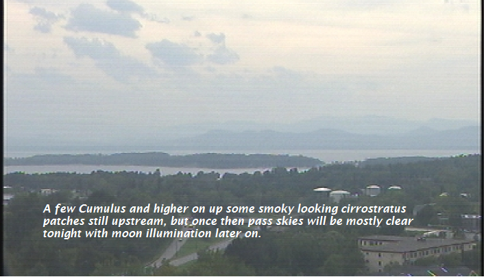
TONIGHT: Mostly clear with some high cloudiness. A low in the upper 50s or around 60. Little wind.

WEDNESDAY: Mixed sun and afternoon clouds after morning fog. Warm and sticky. A high in the mid 80s to around 90. Southwest winds 10 to 15 mph.

Looking further ahead…

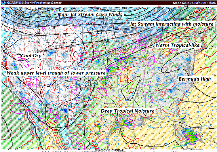
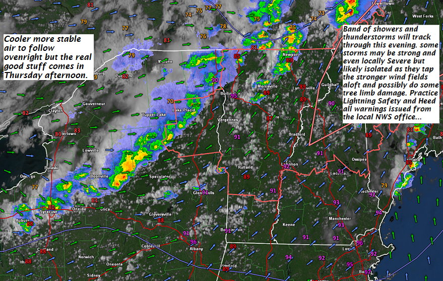
WEDNESDAY NIGHT: Partly cloudy. A rising chance for showers and isolated thunderstorms . A low 65 to 70.

THURSDAY: Morning showers with a chance for a thunderstorm, then increasing afternoon sunshine not as humid in the afternoon. A high in the low 80s.

FRIDAY: Morning fog then sunshine filtered by high clouds. Cooler with low humidity. A low in the mid 50s. A high in the low to mid 70s.

SATURDAY: Morning fog then sunny. A low mid 40s to low 50s. A high mid 60s to low 70s.

SUNDAY: Filtered sunshine through high cloudiness. A low in the upper 30s to mid 40s. A high in the upper 60s to low 70s.

Average lows in the upper 40s to mid 50s. Normal highs in the upper 60s to upper 70s.

RH/9-4-18[end]

Virus-free. www.avast.com

Updated Labor Day Monday Morning Forecast — September 3rd, 2018

TODAY: Partly sunny warmer and more sticky. Isolated to widely scattered later afternoon showers and thunderstorms Barre-Montpelier area north. A high around 85. Southwest breeze 10 mph.

TONIGHT: Partly to mostly cloudy & muggy. Widely scattered showers , maybe a thunderstorm this evening northern areas. A low around 65. Light west to northwest winds.

TUESDAY: Morning clouds then partly to mostly sunny cooler and not so humid. A high around 80. Light northwest winds.

Looking further ahead…

TUESDAY NIGHT: Mostly clear with some high cloudiness. A low in the mid to upper 50s.

WEDNESDAY: Mixed sun and afternoon clouds after morning fog. A high in the mid 80s.

THURSDAY: Variably cloudy. Chance for showers and perhaps strong thunderstorms. A low 65 to 70. A high 80 to 85.

FRIDAY: Morning fog then bright sunshine. Cooler with low humidity. A low in the mid 50s. A high in the low to mid 70s.

SATURDAY: Morning fog then sunny. A tough cooler with morning lows mid 40s to low 50s. A high mid 60s to low 70s.

Average lows in the upper 40s to mid 50s. Normal highs in the 70s.

RH/9-3-18[end]

Virus-free. www.avast.com

Updated Friday Evening Forecast — August 31st, 2018

TONIGHT: Partly cloudy. Patchy valley fog. A low around 55. Slight chance for a few sprinkles Champlain Valley late. Southeast breeze 10 mph.

TOMORROW: A few morning sprinkles or light showers northwestern areas, otherwise partly sunny after morning fog. A high around 75. South breeze 10 to 15 mph.

SATURDAY NIGHT: Mostly clear. Patchy valley fog. A low around 60. South breeze 10 mph.

SUNDAY: Mostly sunny turning a muggy in the afternoon. A high 80 to 85. South to southwest breeze 10 mph.

Looking further ahead…

SUNDAY NIGHT: Partly cloudy. Chance for a few showers overnight far northern areas. A low in the mid 60s

MONDAY Labor Day: Partly sunny warm and sticky. Isolated to widely scattered afternoon showers, maybe a rumble of thunder. A high mid 80s.

TUESDAY: Partly to mostly cloudy. Muggy. Scattered showers and isolated thunderstorms. A low around 65. A high in the low 80s.

WEDNESDAY: Mixed clouds and sun after morning fog. A low in the mid 60s. A high in around 80

THURSDAY: Partly to mostly sunny. “Slight” chance for a shower or thunderstorm. A low in the mid 60s. A high in the low 80s.

Average lows in the low to mid 50s. Normal highs in the 70s.

RH/8-31-18[end]

Updated Friday Morning forecast — August 31st, 2018

TODAY: Morning fog burns off to partly to mostly sunny skies. A high around 75. Light east to southeast winds.

TONIGHT: Partly cloudy. Patchy valley fog. A low around 55. Southeast breeze 10 mph.

SATURDAY: Maybe a sprinkle early Champlain Valley, Otherwise partly sunny after morning fog. A high mid 70s. South breeze 10 to 15 mph.

Looking further ahead…

SATURDAY NIGHT: Mostly clear. Patchy valley fog. A low around 60.

SUNDAY: Mixed sun and clouds and turning a little muggy. An Isolated late day showers near the Champlain valley. A high near 85.

MONDAY Labor Day: Partly sunny, a bit sticky and warmer. Chance for mid to late afternoon showers & thunderstorms north of the Barre-Montpelier area . A low in the mid 60s. A high mid 80s.

TUESDAY: Partly to mostly cloudy. Muggy. Scattered showers and a few thunderstorms. A low 65 to 70. A high in the low 80s.

WEDNESDAY: Mixed clouds and sun after morning fog. . A low in the low 60s. A high in the upper 70s to around 80

THURSDAY: Partly to mostly sunny. “Slight” chance for a shower or thunderstorm. A low in the mid 60s. A high around 85.

Average lows in the low to mid 50s. Normal highs in the 70s.

RH/8-31-18[end]

Updated Thursday Evening Forecast — August 30th, 2018

TONIGHT: Mostly clear and much cooler. Patchy dense valley fog. A low mid 40s to low 50s. Light north winds.

TOMORROW: Morning fog burns off to partial sunshine. A high 70 to 75. Light east to southeast winds.

FRIDAY NIGHT: Partly cloudy. Patchy valley fog. A low upper 50s to around 60. Southeast breeze 10 mph.

SATURDAY: More clouds than sunshine. A high mid to upper 70s. South breeze 10 to 15 mph.

Looking further ahead…

SATURDAY NIGHT: Mostly clear. Patchy valley fog. A bit humid. A low 60 to 65.

SUNDAY: Mixed sun and clouds and turning more muggy. A high near 85.

MONDAY Labor Day: Partly sunny, sticky and much warmer. “Slight” chance for showers, maybe a thunderstorm near the Quebec border. A low in the mid 60s. A high mid to upper 80s.

TUESDAY: Partly to mostly cloudy. Muggy. Chance for showers and thunderstorms. A low 65 to 70. A high in the low 80s.

WEDNESDAY: Mixed clouds and sun. “Slight” chance for a shower or thunderstorm. A low 65 to 70. A high in the upper 70s to around 80

THURSDAY: Partly to mostly sunny. A low in the mid 60s. A high around 85.

Average lows in the low to mid 50s. Normal highs in the 70s.

RH/8-30-18[end]

Updated Thursday morning forecast — August 30th, 2018

TODAY: Scattered showers early, then partial afternoon sunshine. Becoming cooler and less humid by this afternoon. A high in the low 70s. Northwest breeze 10 to 20 mph.

TONIGHT: Mostly clear and much cooler. A low mid 40s to low 50s. Light north winds.

FRIDAY: Partial sunshine gives way to cloudy periods with a chance for a showers southern areas. A high 70 to 75. Light east to southeast winds.

Looking further ahead…

FRIDAY NIGHT: Partly cloudy. A low around 60.

SATURDAY: More clouds than sunshine. A high in the mid 70s.

SUNDAY: Mixed sun and clouds. Slight chance for a few showers. A low near 65. A high 80 to 85.

MONDAY Labor Day: Partly sunny. Chance for a few spotty showers, maybe a rumble of thunder. A low in the mid 60s. A high around 85.

TUESDAY: Partly to mostly cloudy. Widely scattered showers and thunderstorms. A low in the mid 60s. A high upper 70s to around 80.

WEDNESDAY: Mixed clouds and sun. A low 65 to 70. A high in the mid 80s.

Average lows in the low to mid 50s. Normal highs in the 70s.

RH/8-30-18[end]

Updated Wednesday Evening Forecast — August 29th, 2018

Heat Advisories lowest valleys this evening. Severe Thunderstorm Watch in effect through 11 PM this evening.

TONIGHT: Partly cloudy. Scattered showers and few strong to locally severe thunderstorms possible especially this evening. Some storms with gusty wind, hail and lots of lightning. Still muggy. A low mid to upper 60s. Southwest winds 10 to 15 mph shifting to northwesterly overnight.

TOMORROW: Scattered showers early, then partial afternoon sunshine. Becoming cooler and less humid in the afternoon. A high in the low 70s. Northwest breeze 10 to 20 mph.

THURSDAY NIGHT: Mostly clear and much cooler. A low mid 40s to low 50s. Light north winds.

FRIDAY: Partial sunshine gives way to cloudy periods with a chance for a showers southern areas. A high in the low 70s. Light east to southeast winds.

Looking further ahead…

FRIDAY NIGHT: Partly cloudy. A low around 60.

SATURDAY: More clouds than sunshine. A high in the mid 70s.

SUNDAY: Mixed sun and clouds. Slight chance for a few showers. A low near 65. A high 80 to 85.

MONDAY Labor Day: Partly sunny. Scattered showers and perhaps a thunderstorm. A low in the upper 60s. A high around 85.

Average lows in the low to mid 50s. Normal highs in the 70s.

RH/8-29-18[end]

Updated Wednesday morning Forecast — August 29th, 2018

Heat Advisories lowest valleys this afternoon/evening.

TODAY: High cloudiness this morning, then partly to mostly sunny hot and sultry this afternoon. Chance for late day shower or thunderstorm…some strong near the Quebec border. A high 85 to around 90. Southwest breeze 10 to 15 mph.

TONIGHT: Lot of clouds with showers and chance for embedded short-lived thunderstorms. Still muggy. A low around 65. Southwest winds 10 to 15 mph shifting to northwesterly overnight.

THURSDAY: Scattered showers early, then partial afternoon sunshine. Becoming cooler and less humid in the afternoon. A high in the low 70s. Northwest breeze 10 to 20 mph.

Looking further ahead…

THURSDAY NIGHT: Mostly clear and much cooler. A low in the mid 40s to low 50s.

FRIDAY: Partial sunshine gives way to cloudy periods. Pleasant. A high near 75.

SATURDAY: More clouds than sunshine. A low 60 to 65. A high in the low 70s.

SUNDAY: Mixed sun and clouds. Widely scattered showers northern border areas. A low in the low 60s. A high in the low 80s.

MONDAY Labor Day: Partly sunny northern areas with a threat for a shower. Partly to mostly sunny otherwise. A low in the mid 60s. A high 80 to 85.

Average lows in the low to mid 50s. Normal highs in the 70s.

Updated Tuesday Evening Forecast — August 28th, 2018

Heat Advisories lowest valleys thru 8 PM and again Wednesday afternoon/evening.

TONIGHT: Clear in the evening then partially moonlit overnight. Sultry. A low 65 to 70. Light southwest winds.

TOMORROW: Variable clouds with morning showers possible, then partly to mostly sunny in the afternoon. A high 85 to around 90. Southwest breeze 10 to 15 mph.

WEDNESDAY NIGHT: Lot of clouds with showers and chance for thunderstorms. A low around 65. Southwest winds 10 to 15 mph shifting to northwesterly overnight.

THURSDAY: Scattered showers, maybe a rumble of thunder early, then partial afternoon sunshine. Becoming cooler and less humid in the afternoon. A high in the low 70s. Northwest breeze 10 to 20 mph.

Looking further ahead…

THURSDAY NIGHT: Mostly clear and much cooler. A low in the mid 40s to low 50s.

FRIDAY: Partial sunshine gives way to cloudy periods. Pleasant. A high near 75.

SATURDAY: More clouds than sunshine. A low 60 to 65. A high in the low 70s.

SUNDAY: Mixed sun and clouds. A low in the low 60s. A high in the low 80s.

MONDAY Labor Day: Morning clouds give way to increasing sunshine. A low in the mid 60s. A high 80 to 85.

Average lows in the low to mid 50s. Normal highs in the 70s.

RH/8-28-18[end]